The night was peaceful, yet carried an eerie feel with it. Waters under the old bridge were unusually calm, a mist was gathering in the trees. The sudden silence didn’t last for very long, a rumble from below made its way across the land. “An earthquake?!” someone shouted.
The bridge, once the center of the town’s joy, began to crumble. Bricks fell into the waters below, a deafening sound. Then it was gone. No bridge to cross. The town folk, startled from sleep, were stuck on the other side, with no way out.
The next mystery bridge takes us further towards the Czech Republic, right into the town of Olbernhau. With a population of 11,000 inhabitants, the community is known as the City of Seven Valleys, because of the valley of the River Flöha and ist six other tributaries that meet there. Because of that, the community has many historic bridges that one needs plenty of time to visit, even though the length of the crossings are short enough to equal either one 50 foot pony truss span or one arch span of between 15 and 20 meters.
Nevertheless, our focus of this mystery bridge is the longest of the spans, a railroad bridge spanning the River Flöha on the far eastern edge of town, right at the Czech Border. Its exact location can be found in the map below. The bridge is easy to find for when heading east, you cross both the railroad tracks and the bridge before turning right. The railroad bridge is on the right-hand side.
The railroad bridge is one of the most unusual of truss bridges in Europe and beyond. The 68-meter long crossing features a skewed span, where the truss panels are placed parallel of each other along the tracks but in a slanted position at around 60°. That means the truss panel on the left side starts first and after 20 meters, the right one. While there are no portal bracings that support the two truss panelings, the horizontal strut bracings- five panels of them- hold the trusses together. The struts consist of the system of Pratt-heel bracings angled at 15° with the center portion being M-framed. The truss bridge itself is a camelback Lattice truss design with riveted connections, yet they are not the typical truss designs used for the bridges. These have stiffened connections similar to the designs patented by Claus Köpke, an engineer responsible for the construction of the Blaue Wunder Brücke, Marienbrücke and the Alberthafenbrücken all in Dresden as well as a railroad bridge in Riesa. Köpke started his career as a bridge engineer, building bridges from 1872 until his death in 1911. And while he left his mark in the greater Dresden area and parts of Thuringia, it is unknown whether he built many crossings in the Ore Mountains, let alone at this location.
The bridge was built in 1895, according to historic records and is the longest of the bridges, not only in Olbernhau but also along the rail line and the River Flöha. The construction of the bridge was part of the extension of the rail line from Olbernhau to Neuhausen, running along the Czech border. The crossing is part of the rail line that connected Pockau-Lengenfeld and Neuhausen, where the line was completed at Olbernhau in 1873, and 12 years later, extended to Nauhausen. The line was shut down in 2001 due to structural issues along the tracks and other infrastructure, yet was reactivated in 2011 after years of campaigning on the part of the mayor of Olbernhau combined with renovating the line, its train stations, and the crossings along the River Flöha. Today, the Deutsche Bahn Regional Services operates the line as it terminates in Flöha.
The bridge is listed as a German heritage site and has been since 1998, yet still its historical significance is unknown. Did Köpke oversee the construction of the bridge as part of the rail project? If not, was he responsible for the design and another bridge builder took to the task? If neither that nor that, who was the genius behind this design? This question remains open for both the readers and bridge fans, as well as the locals in and around Olbernhau. If you have any information on the bridge builder behind this bridge, please contact the Chronicles. Whatever information is useful will be added here and the Office of German Heritage (Büro für Denkmalschutz) will be able to add this to the file that exists to this day. Whatever you can find will be much useful for the region and its enriched historic heritage.
In other words, your contribution will be of utmost use. Thank you for your support.
Call for help to save a historic bridge in Missouri; A city in Saxony to receive three new bridges; Man pees off of bridge onto ship; A historic bridge gets a new home at a park in Indiana and at a church in Massachusetts; Changes to take place for the Chronicles.
Calls to Halt MoDOT’s plan to demolish Gasconade Bridge
Hazlegreen, MO:The future of the Gasconade Bridge near Hazlegreen is in the balance. Between now and July 5th, the Missouri Department of Transportation (MoDOT) is collecting information from residents concerning the multiple-span through truss bridge that was built 95 years ago but has been closed to traffic since 2015. A replacement span is being constructed on a new alignment to carry a frontage road which used to be Route 66. Should the majority favor keeping the bridge, then it will be up to MoDOT, who had built the structure, to find a way to keep it out of the hands of the wrecker. Information on how you can help can be found by clicking here.
Flöha to Receive Three New Bridges
Flöha (Saxony), Germany-Eight months after a fire destroyed the Apfelsinebrücke (Orange Bridge) near the city center, the city council approved a deal to construct a new bridge that spans the River Zschopau near the City Park Baumwolle. Unlike the previous structure, which was built in the early 1980s, this one will be lower and without steps thus allowing for cyclists to cross. The cost will be 800,000 Euros. It is one of three bridges that the city is looking to replace. The others include replacing the Kirschenbrücke (Cherry Bridge) at Augustusstrasse, which spans the same river. The 120-year old two span arch bridge will be replaced with a beam structure with no center pier in the river. Originally, the arch bridge was supposed to be rehabilitated, yet floodwaters in 2013 caused extensive damage that made even rebuilding the bridge to its original form impossible due to costs deemed exorbitant. The 2.3 million Euro project includes rebuilding the street approaching the bridge. The third bridge to be replaced is a wooden through arch bridge located near Niederwiesa. Built in 2006, the bridge is deemed unsafe due to deterioration in the wood. Its replacement structure will be a steel through arch bridge with truss features. It will still carry the Zschopau Bike trail connecting Flöha and Frankenberg. All three projects are scheduled to start this fall and is expected to last a year.
Man Pees off Historic Bridge onto Tour Ship in Berlin- 4 injured
And lastly, some changes are coming to the Chronicles. After two years in Schneeberg, its main office is being moved to Glauchau, located 10 kilometers north of Zwickau in western Saxony. The city of 24,000 is the center point between the cities of Jena and Erfurt to the west and Chemnitz and Dresden to the east. The move is ongoing and is expected to last through August. The Chronicles will have some pauses in between due to the move. Furthermore, the Chronicles no longer is available on Skrive, for the platform was shut down on June 15th. However, it is pursuing other social media platforms to provide coverage, which will include the use of Spotify and other podcast apps, as well as some local platforms for better coverage in the US and Europe. The project is expected to last until the end of August. To give you an idea of the move, check out the Chronicles’ on Instagram, which has a series on Moving Art.
The next pair of pics will take us to the Oblernhau/Marienberg Region, deep in the heart of the Ore Mountains (Erzgebirge) in south central Saxony. As a general rule, if you can master the tough terrain of steep hills, going up and down like a roller coaster, very sharp curves- mostly combined with bumps and cracks, cobblestone roads that have the potential of being slick when wet and lastly, wild boar running in front of you like a school of raccoons, then you can manage anything. And even more so, some surprises may await you.
In this case, I found one by accident. It’s a multiple-span stone arch bridge that spans a bumpy and curvy cobblestone Highway B 171, a hilly and bumpy road, a deep gorge which also has a river running through. All of it is located in the town of Zölbitz in the district of Rittersberg. The bridge is very difficult to photograph, and because of many cars racing underneath- breaking the 50 km/h speed limit in the process- it is rather dangerous to photograph, no matter at which angle. This was my experience when I photographed this structure. Even with the tree obstructing the view, the bridge presents a nice green and hilly backdrop that is typical for the Ore Mountains. The locals call the bridge Kniebreche not only because of the name of the road, but also because of the way the road is shaped like a bending knee. If one adds the driving portion to the mix, then the trip is definitely a knee-breaker if one is too careless driving in the mountains.
While the bridge looks rather abandoned because of many cracks and plus its dark brown color and vegetable overgrowth on the decking, the Kniebreche Bridge is indeed still in use. The 145-year old structure, measured at a length of 63.4 meters, is still part of the rail line that connects Marienberg with Flöha. In the past it had stretched to Reitzenhain at the Czech border. Yet as of today, the line ends in Marienberg, and the rest has been abandoned with the rails removed and plans of converting the former rail route into a biking and hiking trail with the goal of connecting the latter with the Kammweg Trail, an international route that connects Germany with points in the Czech Republic, Poland and elsewhere. That route runs through Blankenhain, where the Selbitz Bridge is located and the two suspension bridges are scheduled to be built.
Back to the railroad’s history, the line was built between 1872 and 1875. The Chemnitz- Chomotau Railroad Company was in charge of the project but contracted out to a company in Berlin. Given the narrow valleys along the Black and Red Pockau Rivers, bridges, viaducts and dams were built to accommodate two tracks but only one of them was used. The Kniebreche Viaduct was one of them. The line was the most difficult to build, not only because of the steep narrow valleys but also because of the financing. The financial crisis of 1873 forced the contractor in Berlin to liquidate, and the railroad company itself, which did the planning and layout of the railline, to finish the job.
The Kniebreche Viaduct is located in that area where two-track bridges were built even though the purpose was for having a one-track line. It’s location against the steep cliffs of the valley represent a classic example of the struggles the railroad company had in constructing the line. Given as many curves as the highway has, it is not a surprise that the Deutsche Bahn (German Railways) have been using the “red worms” for regional service and leaving the long-distance trains, such as the ICE-trains off the tracks. These types of trains are better off for the long-distance routes, especially between Dresden and the cities of Chemnitz, Erfurt, Leipzig and Prague, for the landscape is flatter and the two-track lines more manageable.
Lennox bridge is the oldest stone bridge on the Australian mainland. It is located in the Blue Mountains and we were lucky enough to stumble across it when we were in Sydney recently.
In 1831 Major Mitchell employed David Lennox, a recently arrived stonemason, to build a permanent road over the eastern escarpment of the Blue Mountains.
It was the first stone bridge built on the mainland and formed the major route over the mountains for the next 100 years and is still used today as a rather hairier way of traversing the mountains.
HAZELGREEN, MISSOURI- The days of the Gasconade River Bridge, which used to carry US Hwy. 66 near Hezelgreen may be numbered as it faces demolition scheduled for Spring of 2020 unless a new owner can be found.
The Missouri Department of Transportation (MODOT) has placed the 95-year old bridge under a 30-day public review and comment period which is halfway through its time and is scheduled to be completed by July 5th. The historic bridge was built in 1924 by MODOT and consists of (from west to east) one 8-panel Warren pony truss with alternating verticals, two 8-panel Parker through trusses and one 6-panel Pratt through truss, all totaling a length of 526 feet. The structure is elgible for the National Register of Historic Places because of its design that was in connection with the standardized bridge movement that started in 1910. It is also in connection with Route 66 and its history, as the Highway, connecting Chicago with Los Angeles via Tulsa and Santa Fe was in operation from 1926 until the last segment of the highway was decommissioned in 1979. Interstate 40 had suplanted the stretch of highway where the bridge is located a years earlier.
Currently, the bridge is closed to traffic and a replacement bridge is being built alongside the historic structure, which will carry a frontage road running alongside the interstate once it’s completed next year. The Gasconade Bridge used to carry that road before its closure in 2015.
Attempts to find an owner for the new bridge and restore the structure to its original glory have not been successful due to differences in planning and realization combined with lack of funding for purchase and restoration. Yet the Gasconade Bridge Facebook (click here) has garnered support from over 1200 Followers and many more who are not on the social media scene. There have been rallies and fundraisers lately and a page where you can donate to save the bridge (click here).
Still the clock is ticking and with the resources and options running out, “only a public outcry expressing significant concern and a desire to save the bridge from demolition might help,” according to a statement on the Gasconade Facebook Page. If you would like to help in convincing government officials to save the bridge, here are the contact details you Need to know before you address your support for the bridge:
E-Mail:STIPcomments@modot.mo.gov
Phone:1-888-275-6636
Mail:Transportation Planning, Program Comments, P.O. Box 270, Jefferson City, MO. 65102.
Identify the Gasconade River Bridge in Laclede County, MO. Give them your name and where you live and most importantly, why this bridge is important and is worth saving. It must be personal; all letters copied and pasted will not be acceptable.
To provide you with an incentive to convince MODOT, here’s an interview I did with Rich Dinkela about the bridge a few years ago. Click here to view. A pair of YouTube videos of the bridge can be found below:
If you have any suggestions to help save the bridge or are interested in buying it, please contact the Group on their Facebook page. A link to their website you will find here.
ELDORADO, IOWA- Approximately 300 feet west of the Eldorado Truss Bridge, one will find a unique diamond in the rough. Located along the north bank of the Turkey River, the first impression that I had during my visit to the bridge in 2011 (see my previous post) was that there may have been a previous crossing- like most of the bridges in Iowa- whether it was a bowstring arch bridge, a truss bridge built of iron or even a covered bridge. One of these three would have clearly fit the description given the need to cross the river from one bluff to another. However, looking at it more closely, especially at the wingwalls and abutments, it is clearly a concrete beam bridge. Unique is the art deco design on the beam span, which is almost a giveaway as to determining what bridge it is. The beam span has two rectangular shapes with a diamond shape in the middle. Most beam bridges and culverts used geometric shapes on their concrete railings when they were introduced for use beginning in 1910, which puts this structure’s build date right into the area of the first two decades of the 20th century. Spanning a creek that empties right into the river, the span is between 15 and 30 feet, which is typical for a box culvert or short-span beam bridge.
The road that the bridge used to carry seems to have gone along the Turkey River and its north shore, having crossed the river twice- one near the site of Orange Ave. Bridge and one at the crossing at Great River Road. Both of them are two miles apart. While the stretch west of the Eldorado Truss Bridge remains in use as 292nd Street it dead ends at a farmstead before the Turkey River crossing. Only a small stretch east of the bridge exists and while much of it has been removed for farmland, one can trace it to the cylinder piers (or lally columns) of the former crossing that is next to Great River Road. A map on the Eldorado Truss Bridge page can help you trace ist origins (click here).
This leads to the following question to be cleared up:
When exactly was the bridge built and by whom?
When was the street, now known as 292nd Street, built and where did it lead to?
What do we know about the former crossings at Great River Road and Orange Avenue, where the former road crossed before joining other streets? We do know with the lally columns at the Great River crossing it was a through truss bridge but what type is unknown…
When was the street and the bridge abandoned?
Any photos, stories and history behind this unique bridge and road would be much appreciated. There are three ways to do it: by e-mail, using the contact info here. By posting in the comment section. And by posting in one of the facebook pages:
NOTE: For the third page, the platform has changed after a successful campaign to save the truss bridge spanning the Raccoon River. The page now focuses on historic bridges in Iowa, which includes truss and bowstring arch bridges as well as others. Click onto the link and like to follow. Despite facebook’s insistence on keeping the old name, it will eventually change to reflect on the focus on historic bridges in the state.
While we are still in Iowa, here’s another Pic of the Week. Yet this time, we travel to Fayette County in eastern Iowa and the town of Eldorado. Located between Calmar and West Union along the Turkey River, the village is tucked away in the hills of the Bluffs Region, which extends from southeastern Minnesota into the eastern part of Iowa, where all creeks and rivers empty into the Mississippi River. Eldorado has about 200 people and a few historic buildings, but one unique truss bridge. The Eldorado Truss Bridge is a Camelback through truss bridge with M-Frame portal bracings. It was built in 1899 by J.C. Ratcliff, a local bridge builder based in Waukon in Allamakee County and is the only known bridge built by the engineer to date. The 130-foot long bridge has been closed to traffic for a couple decades, yet still remains its historic integrity to date. It can still be accessed from the State Street side and if one is lucky, one can find some shells along the Turkey River, which was my case upon my visit in August 2011. Despite record rainfall in the spring, which caused massive flooding along the Missouri River, water levels receded to a point where one could walk along the river and get a few shots from the river bed, something that was done on a perfect afternoon, while traveling through Iowa.
As a bonus though, there is one bridge nearby, whose mystery has yet to be solved. More on that in the next article here. 🙂
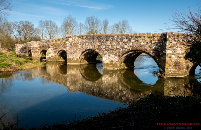
Crawford Bridge, Spetisbury – the upstream side with cut-waters
Sometimes it pays to be cheeky 🙂 !
The picture above is one I have wanted to get for a long time and I managed to capture it yesterday, although I would have preferred some late afternoon sunlight on the bridge – this was taken too early for the ‘golden hour’. It is a picture that is not normally possible because the land I’m stood on to take it is someone’s private garden. Every time I walk across the bridge, I hope to see someone mowing the lawn so that I could get chatting and hopefully be invited into the garden but it has never happened. So yesterday I decided to just ring the doorbell and ask!
The cut-waters from one of the pedestrian refuges
When the man answered the door, I said, ‘Sorry, I know I am being really cheeky…
It was 1944 in Benouville, a little village in France. German soldiers had occupied it for four years. Every day, they infiltrated the humble little town for food, drinks, and supplies. They didn’t always ask nicely either. They invaded private homes for billets, and they constantly paced back and forth over the gray-painted road bridge […]
This is a blog about my project of visiting every bridge over the Genesee River and what I learned about the history, structure, and natural surroundings of each bridge.


 © irene waters 2019
  © irene waters 2019
  © irene waters 2019
  © irene waters 2019
  © irene waters 2019


 Crawford Bridge, Spetisbury – the upstream side with cut-waters
  The cut-waters from one of the pedestrian refuges

