The Fight to Save Fehmarn Island from Progress

Fehmarn Bridge side view new

Co-produced with sister column The Flensburg Files

FEHMARN, GERMANY-   Last fall, the Bridgehunter’s Chronicles did a segment on the preservation of the Fehmarn Bridge, the first bridge in the world that carries the now popular basket-handle tied arch bridge span. The battle is part of the series where residents of Fehmarn Island are fighting with both the German and Danish governments to stop a project where the Migratory Bird Route, connecting Hamburg and Copenhagen, would be widened- both the highway and the railway. This includes new bridges to replace the Fehmarn Bridge and a tunnel on the opposite end connecting Puttgarden (D) and Rodby (DK). And lastly an industrial areal was planned for the island.  Unfortunately, despite the Areal being blocked earlier this year, the European Union, according to reports from the BBC, has given Denmark the green light to start the construction of the tunnel, by providing 589 million Euros in the next four years for the project.

Yet while the Danes are prepared to start work beginning this fall, residents of the island and the surrounding area along the Baltic Sea coast are up in arms against the project and have started their own initiative to stop the project.

IMG_9607

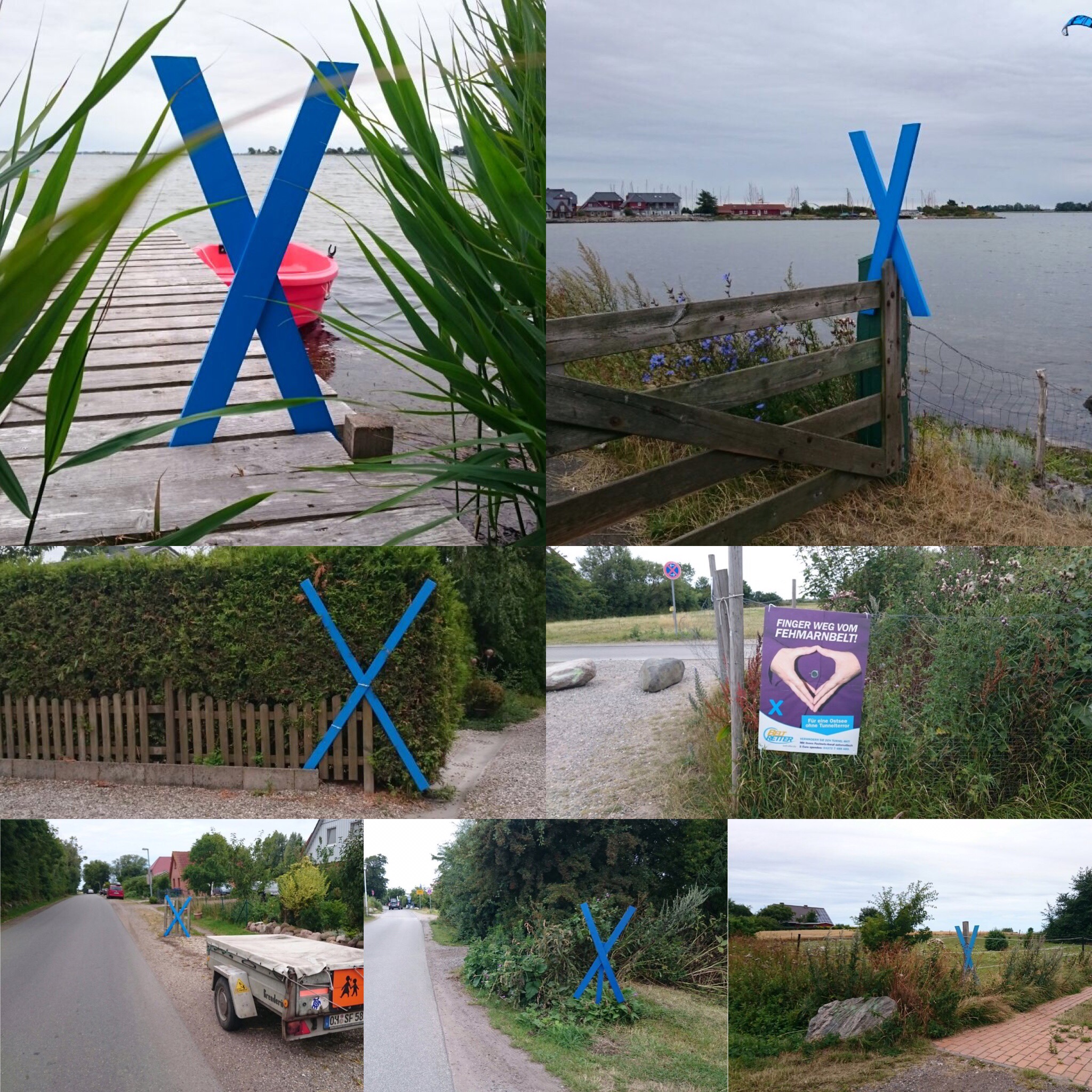
Tourists and locals have seen the blue X’es popping up in neighborhoods, along highways and beaches and even in the skies between Hamburg and Lübeck and the island itself. The Blue-X Initiative was adopted by the group Beltretter, with the purpose of showing support for preserving the island and stopping the project from taking place. Almost one in every three households have this on their lawns as a way of demonstrating solidarity against the project. And there are many reasons for this initiative:

1. The construction of the tunnel would coincide with the expansion of the highway and rail line going through the island as well as the construction of the new Fehmarn Bridge, resulting in the island becoming a construction site. As small as the island is, and with the economy being dependent almost solely on tourism, analysts predict a loss of up to 800 million Euros (or close to $1 billion) in revenue during the time of the construction because of loss of tourism and commerce, plus additional money to improve the island’s imagery once the project was completed, which could take years to complete.

2. The project would involve a loss of sensitive vegetation and marine life that would be immense and possible irreplaceable. This includes the plan to scrap the underground tunnel similar to the Euro-Tunnel connecting France and Great Britain in favor of one above the sea floor, similar to the Oresund Bridge and Tunnel between Copenhagen and Malmö (Sweden), which could be devastating to marine life alone. The width of the construction area between Puttgarden and Fehmarn Bridge would average approximately five kilometers. The maximum width of the island is only 21.8 kilometers- and this given the size of the land to be 185 squared kilometers!

3. Some discreptancies in the environmental and economic impact surveys conducted by Denmark have resulted in rechecking the figures. Alone with the economic impact survey released in January 2015 led to a debate on the credibility of both the Danish government, the conglomerate spearheading the tunnel initiative Fehmarn A/S, and even the European Union. While both Denmark and the EU claim that the new crossings would produce a revenue of 4-5% of the gross domestic product in the region or approximately 3.48 billion Euros ($5.5 billion), other surveys indicate that the loss of revenue through construction combined with years of recovery, the new crossing would net an annual loss of 6.7 billion Euros ($8.2 billion). For the residents on the island, the risk would be too high to take.

4. While there is a one-track rail line that is suitable for transport between Hamburg and Copenhagen including the time needed to cross via ferry, there is another border crossing at Flensburg and Padborg, where they feature a freeway and a two-track rail line connecting Hamburg with Aarhus with a arm going to Copenhagen via Odense. At the present time, improvements are being made in the Flensburg area to make the crossing more attractive. While the logic behind expanding the line through Fehmarn is there, little do government authorities realize that Fehmarn is a vacation and natural area whose need for a freeway/ two-track crossing on both ends of the island would devastate the natural habitat and impact tourism negatively. In other words, better to go through Flensburg if you wish to stay on the freeway going to Denmark and not stop to go swimming.

IMG_9638

While officials in Denmark are preparing to start building the tunnel from the Rodby end, officials in Germany are in the process of discussing the project with many parties involved. This after the application for the construction of the new Fehmarn Bridge, new freeway and tunnel was submitted to the state ministry of transport. The communities affected will have a meeting in September, followed by the environmental groups, including BeltRetter in November and residents affected by the construction afterwards. The ministry will then review the opinions and information provided by those affected before making their decision- a process that could take up to a year.  Proponents of the project have already received a backing from The German Railways (The Bahn) and German Minister of Transport Alexander Dobrindt, the former wanting to expand and electrify its rail line to run more ICE-Trains on there.

But with the opposition towards the project crystalizing and spreading beyond the region, problems will most likely excaberbate over the course of two years, especially when the blue X’es sprout up everywhere making the area as blue as possible. Since blue is the sign of clear water, the water people deserve to swim in and marine life to inhabit, it also is a sign of preserving things as they are. With more initiatives coming up and more support pouring in, there is a chance that the project could be stalled further or even scrapped. If this is the case, then there will still be some work to be done with its current infrastructure to keep it up to date, but residents will breathe a sign of relief, for having a mega-highway for the sake of expanding commerce is not necessarily what they want. In fact with all of information on the negative impacts, combined with questions involving the credibility of the sources, this project in the end will do more harm to the region than good. This is something no one is willing to gamble on.

The Flensburg Files and the Bridgehunter’s Chronicles are proud to support the initiative to preserve Fehmarn Island and its places of interest. Both columns will provide you with further updates on the latest involving the project. If you wish to take part in the initiative and want to donate for the right cause, please click on the following links. There you have information on how you can help.

Beltretter

Bewahrt Fehmarn (Preserve Fehmarn)

Comp2Kreuze CompKreuze Unknown-12 Unknown

FF new logo1  &  bhc new logo jpeg

Special thanks to Mirko Kaminski for the use of the photos, as well as Karin Neumann and Hendrick Kerlen for their help in contributing some valuable information for this story.   

Rome Bridge Gone!

Photos taken by James Baughn

ROME/SPRINGFIELD, MO-  While flooding has taken its toll on many bridges in the region, another bridge located in Douglas County, Missouri met its end yesterday. Yet the removal was planned. The Rome Bridge was a two-span Pratt through truss bridge featuring a four-rhombus Howe Lattice portal bracings with curved ankle braces. The 102-year old bridge was the product of the Kansas City Bridge Company but was built under the direction of J.H. Murray and Company. Upon completion in 1913, the bridge was 201 feet long (two 100-foot truss spans) and 15 feet wide.

Yet despite its historic significance and its proximity to a nearby park, talks had been underway to replace the bridge for three years because of structural concerns and its age. Attempts were undertaken to convince county officials and a preservation group to take a stand to stop the plans for replacement, part of that was in connection with the successes with the Riverside Bridge, which had been fixed and reopened prior to the unveiling of the plans to tear this bridge down. Unfortunately, to the dismay to many preservationists and locals, the ideas fell on deaf ears as county officials went ahead with the replacement project. With the truss bridge now reduced to a pile of scrap metal, a replacement bridge will take its place, most likely being scheduled for opening to traffic by the end of the year at the earliest. But memories of the bridge will remain and a facebook site (which you can click here) features a gallery of photos and videos of the bridge when it was still in service. There are a pair of videos below, which takes you across the bridge- that is before it was taken down yesterday.


https://video-fra3-1.xx.fbcdn.net/hvideo-xfp1/v/t42.1790-2/11735154_10153515964179187_1697948927_n.mp4?efg=eyJybHIiOjU0MCwicmxhIjo1MTJ9&rl=540&vabr=300&oh=d3f50c13cc18f9d1dcb44995b326d912&oe=55AF5F76


bhc new logo newsflyer

Riverside Bridge in Ozark Closed Again

Photo taken in August 2011

Flood Damage Prompts Immediate Closure; Replacement being Considered

OZARK/ SPRINGFIELD, MISSOURI-  At about this time four years ago, attempts were made to raise funds, sign petitions and collaborate with government authorites to save and repair the Riverside Bridge in Ozark, a 1909 Canton Bridge Company product that has been spanning the Finley River for 106 years, serving as a key crossing to the northwestern part of the city. All these efforts bore fruit as the local road authority allowed for repairs to be made and the bridge to be reopened, all in 2013. These successful attempts garnered state, national and international recognition.

Sadly though, the bridge’s days may be numbered. For the second time in five years, the bridge was closed to all traffic today.  Record setting flooding in the region resulted in much of Ozark and Springfield becoming inundated and bridges being five feet under water. The Riverside Bridge was one of them, as floodwaters washed over the bridge and only the top half of the bridge could be seen. When floodwaters receded, officials from Missouri Department of Transportation inspected the bridge to reveal structural damage to the railings and the lower chords. The bridge will be closed indefinitely until plans are revealed regarding the structure’s future. According to news channels covering the story, it appears that replacement is likely, although both MoDOT and the City of Ozark agree that the historic bridge should be saved, repaired and used again.  The bridge’s closure means it is back to the drawing board for many people who were part of the Save the Riverside Bridge group, led by Kris Dyer, for efforts to save the bridge took 2 years before the city gave the go ahead to rehabilitate and reopen the bridge. With the bridge closed again, the question now has become: “What’s next?”

A video with the interview with the local engineer explains that the repairs are possible but in the long term, replacement may be unavoidable:

Judging by the photos and videos, the damage to the bridge was mainly due to debris slamming into and getting entangled into the bridge. The rest of the structure appears to be in shape. Yet officials would like to see the bridge replaced and the truss bridge relocated. This is in part due to property rights issues around the structure. But suppose instead of replacing the bridge, one can supplant the truss bridge into a concrete bridge, where the trusses lose their function but serve as a decoration, but the concrete bridge would act as the crossing? With several examples existing in places like Indiana and Minnesota, it is an option worth considering. While a new bridge will cost up to $3 million, the cost for such a project will be just as much. Yet one thing is clear, no matter what happens to the bridge, rehabilitating it, replacing it and relocating it, or even placing it onto a concrete bridge, action will be needed to ensure that the next flood will not take out the crossing altogether. That means, a little bit more money will be needed to save the Riverside Bridge.

The Bridgehunter’s Chronicles will keep you informed on the latest developments regarding the Riverside Bridge. Click onto the highlighted links to take you to the bridge, its history and the attempts to save it the first time around.

bhc new logo jpeg

Firth of Forth Bridge now a World Heritage Site

Forth Railroad Bridge in Scotland. Photo taken by Mark Watson

EDINBURGH/ BONN: One cannot miss this beauty in red when travelling along the Firth of Forth in Scotland. Built in 1890, the three-span steel cantilever bridge still carries rail traffic after 125 years. The work of Sir William Arrol and Company, the bridge was the first of its kind built of steel, and massive enough to withstand the highest winds, even today. The bridge is still considered a work of human ingenuity that has yet to be surpassed, with over 4,500 people responsible for contributing to this ambitious project, according to UNESCO. While the 1.5 mile long structure had received many accolades, including the Chronicles’ Ammann Awards for Best Photo International this past year, the induction into the World Heritage List, provided by UNESCO, serves as the cherry on top of a large red cake that toom 82 years of planning and construction before opening to traffic in 1890 and is still standing ever since. Officials at UNESCO in Bonn today declared this bridge a World Heritage Site, thus making it the ninth bridge (and the third in the United Kingdom) to receive such a prestigious award. The bridge now joins the likes of the Statue of Liberty in New York, The Pyramids of Egypt, The Great Wall of China and even the newly listed Speicherstadt district of Hamburg (Germany) as the places of international importance, which will most likely increase revenue from tourism and the like.

More information on the Forth’s induction can be found here. The Chronicles would like to say congratulations on receiving such an honor.

And for those wondering what other bridges are on the World Heritage List, here is a list where you can click onto the link to obtain information on them:

Stari Most Bridge and the Old Town of Most (Bosnia-Herzegovina)

Mehmed Paša Sokolovi? Bridge in Višegrad (Bosnia-Herzegovina)

Pont du Gard (Roman Aqueduct) (France)

Avingnon Bridge (France)

Aqueduct of Padre Tembleque Hydraulic System (Mexico)

Vizcaya Bridge (Spain)

Iron Bridge Gorge (UK)

Pontcysyllte Aqueduct and Canal (UK)


bhc new logo newsflyer

Donora-Webster Bridge Gone

107-year old historic bridge brought down by explosives at 9:00 am CDT today. Fate of Webster uncertain

DONORA; WEBSTER; PITTSBURGH- The bridge once stood out over the Mongahela River as the symbol of unity between two villages located southeast of Pittsburgh. Many vehicles had crossed the 107-year old structure, at least 150 per day prior to its closing in 2009 due to structural concerns.  Six years after its closing, the bridge is now a memory, with the river now dividing the two villages. The Donora-Webster Bridge was brought down by explosives this morning at 10:00am EDT (9:00am CDT/ 4:00pm Berlin Time). Prior to the historic event, two of the four Parker through truss approach spans on the Donora side plus the steel trestle approach spans on the Webster side had been removed, leaving the Pennsylvania petit main span and the remaining Parker truss spans on each end to be set up for implosion. Here’s a video of the implosion that happened this morning:

Hundreds of people from both villages paid their last respects to the bridge, yet the removal of the bridge, without any plans for a replacement span has left both villages reeling. Especially for the village of Webster, the fate is uncertain, as the community used to feed off its commerce from its sister village Donora, thanks to the bridge. It was built in 1908 by the Toledo-Massilon Bridge Company of Toledo, Ohio, with A.N. Nelson presiding over the construction of the bridge totalling 1547 feet (471.7 meters), with its main span being 517.5 feet- one of the longest in the country. A drone film of what the bridge looked like can be seen below:

When the bridge was closed in 2009, hundreds of locals still used the bridge to cross from point A to point B, while hundreds more from all over the US and Europe paid homage to the crossing in hopes that PennDOT will repair and reopen the bridge. The author was at the bridge as part of the tour itinerary of the 2010 Historic Bridge Weekend in western Pennsylvania. The bridge was quite massive and appeared to be in pristine condition with only a few rust spots that could have been repaired easily, as well as replacing the decking. Still, to the confusion of many locals and preservationists who do not understand the logic behind PennDOT’s decisions (especially as they had a tight budget), the fate of the bridge was sealed when bids were given out at the end of last year and the contractor agreed to remove the bridge by July of this year.  No replacement has been planned yet, which is causing many businesses in Webster to either close up or relocate to the Donora side. Many residents are also moving away, which will eventually result in Webster becoming a ghost town by the end of this decade. Speaking from the experience of residents in Meadville, whose businesses were adversely affected by the closure of the Meade Avenue Bridge for seven years, this rippling effect of not having a bridge as its main link is understandable. And while the project to replace that bridge is underway, there are no plans for the Donora-Webster Bridge as of right now. And given the current situation, it appears the decision will be an indefinite one, which will be fatal for Webster and for residents being forced to drive seven miles to the nearest bridge on each end, especially for emergency crews, a true inconvenience that people will have to get used to, no matter what the cost.

Some more information about the bridge can be found via historicbridges.org here. The author took many photos of the bridge during his trip in 2010, all of which can be found via bridgehunter.com here.

bhc new logo newsflyer