Wartime Bridge Story: Lange Brücke in Forst (Lausitz)

Source: A. Savin vis wikiCommons. Photo taken in 2016

Wartime Bridge Series

Film clip

Our next Wartime Bridge takes us a bit further south in the German state of Brandenburg but this time, we continue along the Neisse River until we reach the city of Forst. With a population of 18,000 inhabitants, the city is located east of Cottbus. Prior to the Fall of the Wall, Forst was well known for its textile industry, for a large factory was located there. Yet since its closure, the city has been on the decline, falling from 31,000 inhabitants in 1945 to under 20,000 by 2011. Despite its steady decline, the city is dependent on tourism as there are several historic artefacts one can see either by bike or by car, including the historic water tower, the factory, the church and historic city center…..

…..and its bridges that span the River Neisse.

There are four bridges that connect Forst with its neighbor to the east, Zaseki on the Polish side. The village of 250 inhabitants used to be a suburb of Forst when Germany had its state of Schlesia. In fact the town was modernized beginning in 1897 to accommodate more people as many of them found jobs in the textile factory and other industrial sites nearby. Three bridges connected Forst with its former neighbor prior to 1945. Today only one of them, a six-span truss span is still in use, providing rail service to Lodz from Cottbus.

And this is where we look at the other two bridge ruins- one that used to serve vehicular traffic and one that used to serve pedestrian traffic. The pedestrian crossing had been in use from the 1920s until the end of World War II and  featured multiple spans of concrete, using Luten arches.  The other one is known as the Lange Brücke.

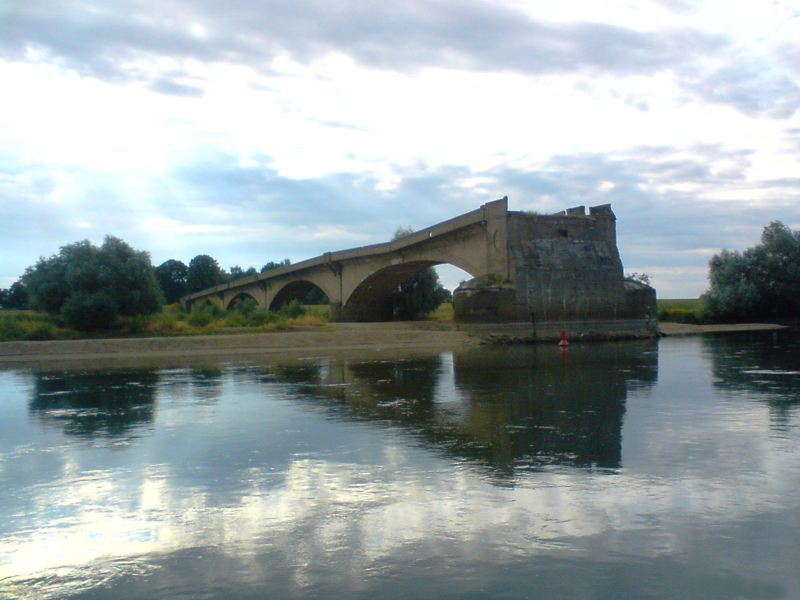
The Lange Brücke was a six-span concrete arch bridge with closed spandrels. The structure was built in 1921 and had a total length of 170 meters. The width was about 14 meters. It was an ornamental structure where it was decorated with fancy light posts and rail posts at the entrance to as well as on the bridge. The bridge was a predecessor to a wooden crossing, which featured multiple spans of kingpost pony trusses. It had been built in 1863, had a total length of 101 meters and was only 5.75 meters wide. In 1889, it was widened by another 3 meters. Still, because of the increase in traffic due to the expansion of Forst, the city council agreed to build a new span, which took two years to complete.

Neither of the bridges survived as well as much of the city of Forst in 1945. In the middle of February of that year, the Soviet troops had lined up on the Polish side of the River Neisse at the entry to the Lange Brücke. While it is unknown whether the Nazis had blown the structure up prior to that, it was known that Forst became under seige with bombs and bullets devastating much of the city. Half the population had perished by the time the town surrendered on 18 April, 1945; 85% of the city was in ruins.

A video showing the ruins of the Lange Brücke can be seen here. The river span was the only one imploded, while the outer spans have remained in tact. Interestingly enough, many of the ornamental relicts belonging to the bridge are still standing today.


At the present time, talks are underway to rebuild the Lange Brücke and its pedestrian counterpart in an attempt to reconnect Forst with Zasieki. The city council had originally planned to add at least two bridges to the Neisse before 2020. At present the Northern Bypass Bridge, which carries Highway 157 is the only vehicular crossing that connects Forst with Poland. The concrete structure was built only a few years ago. The railroad bridge to the south of Forst is the other crossing. It’s a contrast to the situation in Eisenhüttenstadt (see article), but there’s a ways to go. Because of the interest in a central connection via Lange Brücke, it is very likely that a new span will be built sometime in the near future, whether it is reconstructing the Lange Brücke to its original glory or building on on a new alignment and leaving the old one as a monument. The question is with not only the planning but also the finances, especially during these difficult times with the Corona Virus. But nevertheless, a new bridge will happen because of the will of the people to make it happen.


bhc tour guide

As a treat, I have this video showing the ariel view of three of the four crossings connecting Forst and Zasieki. Check out the gorgeous views of the bridges from up above and up close.


Sources:

History of Forst: https://edoc.hu-berlin.de/bitstream/handle/18452/7622/knpv.PDF

History of the Bridge: https://www.lr-online.de/lausitz/forst/die-alte-_lange-bruecke_-36431060.html


BHC 10 years

Can Italian infrastructure reboot post-virus economy?

Pressok

Rome (AFP)

A sleek new bridge in Genoa built in record time is being acclaimed in Italy as a model for rebuilding the economy by investing in major infrastructure projects.

Such stimulus is sorely needed as the country slides towards its worst recession since World War II because of the coronavirus pandemic.

The completion of the Genoa bridge was hailed as a sign of renewal for Italy
The completion of the Genoa bridge was hailed as a sign of renewal for Italy Marco BERTORELLO AFP/File

The government admits it badly needs to renovate crumbling roads, bridges and railways, and doing so could also save lives. Yet the possible impediments are many — from funding to political will, bureaucracy and a recent safety reports scandal.

The completion of the Genoa bridge was hailed as a sign of renewal for Italy, where over 28,000 people have died in the coronavirus pandemic and millions risk losing their jobs due to an economically-crippling nationwide lockdown.

The hi-tech flyover “is…

View original post 1,387 more words

Oderbrücke at Fürstenberg at the German-Polish Border

Remains of the Bridge. Source: Lechita / CC BY-SA (https://creativecommons.org/licenses/by-sa/4.0)

Wartime Bridge Series

Our next bridge in the series keeps us in Poland but we go towards the Oder-Neisse border to Germany. Specifically, to this bridge at Fürstenberg- or what’s left of it.  This bridge spannned the River Oder at the Polish-German border near the village of Fürstenberg in the German state of Brandenburg.  The River Oder is one of the widest and most navigatable rivers in Poland for 80% of its 742 kilometers can be travelled by boat as it flows through the western part of the country. Its width of over 300 meters in areas is largely due to it confluencing with rivers, mostly from the German side as well as it flowing through a large lagoon in the northwestern part of the country before it empties into the Bay of Pommerania at Swinemünde.  Its width made it difficult to build many bridges along the river.  And this leads us to the bridge remains.

The bridge was built by August Klönne in 1914 and was the only crossing over the River Oder in Fürstenberg prior to 1945. The 600 meter bridge featured four concrete closed spandrel arch approach spans on the Polish side and a steel through arch span with Pratt truss upper chords as its main span over the river- half the length of the entire structure. The through arch span is signature of the bridges that were built by Klönne and many of these spans still exist today in Germany, including the famous Hollernzollern Bridge in Cologne.  A diagram depicting the bridge at Fürstenberg can be seen below:

fürstenberg br
Source: structurae.net

This takes us to the event where the crossing was brought down.  After a failed attempt to bring down the Jastrowie Bridge (see the article here), German soldiers fled towards the river and used it as its stopping point for advancing Soviet armies that were closing in on Berlin at an alarming rate. To buy them some time and regroup for their possibly last stand against the Soviets, Hitler ordered all the bridges along the Oder and Neisse Rivers to be blown up. One day after the Jastrowie Bridge partially collapsed, the Fürstenberg Bridge was detonated. While the steel arch span was brought down, the arch spans remained in place. Unfortunately, one person was killed in the explosion, a Justus Jürgensen, who was later given the Ritterkreuz post humously on 5 March. Still the honor would not stop the Soviets and Polish troops from occupying the town.  The bridge remains on the Polish side can be seen through a video below:

What became of Fürstenberg at the end of World War II was a totally different story.  The bridge was never rebuilt and all that remains are the arch spans on the Polish side.  Poland was freed and the border along the Oder and Neisse was reestablished. As many as 8 million Germans living east of the border were subsequentially expelled to the German Democratic Republic (East Germany), which was under Soviet control until a government was established in East Berlin in 1949. The community of Fürstenberg that had existed since the 13th century folded into a newly created Communist city that became known as Stalinstadt, named after the Soviet dictator and one of the victors of the war, Josef Stalin.  The city had 15,000 inhabitants when it was established in 1951 but thanks to the industries and Communist-style apartments that were built there, the population had reached an all-time high of 53,500 people by 1988, including many displaced Germans from the Polish side.  It was renamed Eisenhüttenstadt in 1990 and at present, only 23,000 people live there. It remains the only city in Germany that has no bridge along a major river. Those wishing to cross into Poland have to through Frankfurt (Oder) or Guben; in each direction at least 30 kilometers.

While Fürstenberg became Eisenhüttenstadt and still has a predominantly Communist cityscape but without a bridge over the River Oder, much of the historic old town still remains in tact, including a large church and a former city hall. It is still considered by many to be a border town because of the Oder-Neisse boundary and its location on the river. Still there is hope that after 75 years, planners will come through with a crossing over the Oder that will eventually bring the two countries together and with that, the villages on the Poland side and Fürstenberg on the western side. Whether this will happen depends not just on the finances but also the will of the people to make it happen.

BHC 10th anniversary logo1

Sometimes I go looking for a specific building or building type in research and serendipitously come across a structure that I had not heard of and wish I’d seen sooner. An example is the small truss bridge above, which spans a railroad line and carries a small local road in rural Pennsylvania. It was moved […]

via Construction History: An Ancestor — Old Structures Engineering

Jastrowie Rail Bridge in Poland

99431247_293274785034283_4521043191814266532_n
Source: https://gramho.com/media/2315186164545818312

Film clip

Wartime Bridge Series

Our next Wartime Bridge story takes us to northeastern Poland and to the town of Jastrowie. With a population of 8900 inhabitants, the community is located on the edge of the Gwda River valley. Germans have translated the river’s name into Küddow. During World Was II, Jastrowie was a stronghold for Nazi soldiers especially as a railroad line had existed and it was needed to ship war supplies and other materials to the areas needed, especially as soldiers on the eastern front tried to invade the Soviet Union and were only 60 kilometers away from Moscow by the end of 1941.

By the beginning of 1945, with the Nazis fighting a losing battle with the Allies encroaching Germany and its capital Berlin from all sides, Soviet troops were making strides as the soliders, tired and worn out from the fighting, were fleeing towards Germany, marching through Poland along the way. Despite Adolf Hitler’s orders to fight to the very end, there were only three options for the Nazi soldiers:

1. Fight until death,

2. Slow the advancement of Soviets to buy time to retreat and eventually regroup or

3. Desert the army and if caught, accept the terms of surrender with the hope of returning home to their families.

In the case of this bridge at Jastrowie, it was the attempt of carrying out option 2  that went as awry as it could be.  The railroad bridge was built in 1914 and spans the River Gwda east of Jastrowie. It can be seen from the State 189 Bridge as it is approximately 300 meters away to the south. While it is unknown who built the bridge, the inscriptions on the truss beams indicated that a Union Steel Company may have fabricated the steel parts to put together the polygonal Warren deck truss design.  Because Poland was part of the German Empire until the end of World War I, it is most likely that the company came from the German side.

Attempts to blow up the bridge to slow the advancement of Soviet troops happened on 2 February, 1945 as Nazi soldiers tried to bring the bridge to the ground using explosives. Unfortunately, due to a lack of explosives and other materials needed to destroy the bridge, combined with the quick advancement of the encroaching soldiers and opposition from locals in the area, only one side of the bridge came down, the other was still attached leaving the truss span hanging on one side. It has been in this partially collapsed position ever since. A video shows the partially collapsed span in full detail:

While the Soviets captured the city on the same day, they would remain in the region for another 44 years. Although Poland was reestablished as a country, it became part of Soviet control through the Potsdam Agreement of 1945, when Germany, and eventually the rest of Europe was divided into East and West.  While under Soviet control, residents of Jastrowie were forced to resettle further westward as much of the population were of German descent. It was part of the practice by the Soviet Union and the eastern European countries that had been under control of Nazi Germany but were later reestablished as individual states. People of German descent were rounded up and deported to what later became the German Democratic Republic (East Germany), their assets seized and redistributed among the native populations, including the Polish in Poland and the Slavics in what later becamse Czechoslovakia.

Because the town was emptied, the bridge and the rail line were both abandoned and have remained ever since, thus making it an important and popular tourist stop for bridge enthusiasts and photographers. Even some Polish bloggers have written about the bridge, one of which can be found here and is loaded with detailed photos of the bridge. More information about the bridge is found there but in Polish.

The Jastrowie Bridge is one of many historic structures that survived the Nazi attempts of being blown up for the sake of stopping the advancement of troops and delaying the inevitable. It is however one of the community’s prized historical treasures that serves as a reminder of how the residents survived two different occupations- one of which included the forced deportation to East Germany following the end of the war. It is also fortunate that the bridge has remained in tact for the purpose of future research on its history. While the chances of it being restored and reused as a bike trail crossing along the River Gwda is slim, historians can take the opportunity to learn about the structure’s history, not only tracing the history of Union Steel but also find out who was behind the construction of its unique design.  A relict as a memorial makes a community stand out as one that has gone through a lot over the years. And that in itself makes it an attraction for historians, bridge fans, photographers and tourists alike.


fast fact logo

Poland was occupied three times since its establishment in 1595: The Polish Partition happened from 1795 to 1918 in which the country was divided into three parts: the eastern part belonged to the Russian Empire, the southern part to the Habsburg Empire (Austro-Hungarian) and the western part to Prussia, which later became the German Empire through its creation in 1871. After being reestablished via Versailles Treaty in 1918, Poland was an autonomy until September 1, 1939, when Nazi Germany invaded and eventually captured the country. It remained under control until the Soviets drove them away in warfare successfully in 1945. After being part of the administration, Poland became a puppet of Communism until free elections of 1989, which led to it becoming an independent country. For more information on Polish history, click here.


BHC 10 years

BHC Pic of the Week Nr. 99

BHvH1

Our next Pic of the Week takes us to the city of Bad Homburg vor der Höhe, a city located north of Frankfurt in the German state of Hesse. While visiting the city, one can be impressed with its modern character, even though some of the historic elements that had existed prior to World War II still exists. But as you walk along the Hessen Ring, you will happen to run across this unique, modern treasure. The bridge is a cable-stayed span built in 2002 and has a total length of 76 meters. The width is 46 meters.  The object that stands out with this bridge is its pylon in the center median of The Ring. It’s 15 meters high and has a 3D-style, Y-letter shape. The arms from the Y-pylon support the cable suspenders which keep the decking up and in place.  When I was there in 2008, which is where this pic came from, it was one of the first cable-stayed bridges with such an unique shape, something I had never seen before.

BHvH2

I chose this bridge for it was recently renamed after a prominent local.  Alfred Herrnhausen, a local from the city, was a banker and the chairman of the Deutsche Bank, when he was assasinated on 30 November, 1989. Although he was in an armored convoy, one of the bullets penetrated it, mortally wounding him. While the Royal Army Faction (RAF) claimed responsibility for the attacks, the murder has remained unsolved for the police was unable to find who actually killed him.  The bridge was renamed Herrnhausenbrücke in his memory. The ceremony took place on 30 January of this year with many of his close relatives and associates on hand.  While the group has ceased to exist for over two decades now, the RAF was a left-wing terrorist organization that had existed for almost three decades (1970-1998) and killed 34 people. 27 of its members however were either killed by police or commited suicide.

This is the second bridge in the city that was named after a local behind the Ernst Ritter von Marx Bridge, yet there are some interesting structures worth seeing while in Bad Homburg. One of them is a pedestrian bridge with a loop-shaped approach, which mimicks the Rendsburg High Bridge and the Hastings Spiral Bridge. That can be found at Dorotheenstrasse.

loop

Nevertheless, the structure presented in this article fulfills the rule of thumb pontists should always follow when touring a city: Start with the bridges first- you will be amazed at what a community has to offer. Bad Homburg definitely fits into that category like a glove. But there will be more communities that will follow in this website that have some unique diamonds in the rough, aside from what is listed in the BHC’s Tour Guide section.

So stay tuned for more. And don’t forget about the bridges when visiting a community next time, OK? 🙂


BHC 10 years


A longtime resident of Chicago, Illinois, James McDonough is a diversely experienced executive who most recently led McDonough Associates as CEO and chairman. Earlier in his career, James McDonough served the City of Chicago as a supervisor and later manager of the Chicago Skyway Toll Bridge. Construction for the Chicago Skyway commenced in 1956. At […]

via A Look at the Historic Chicago Skyway — James McDonough

I went looking for another bridge after yesterday’s arch, and I found this little guy. I’m sure there’s information out there, but in the time I was willing to spend, all I got was the rather spare description in HAER: it’s over Maggie Creek, eleven miles west of Elko, Nevada. I also learned that Maggie […]

via Far and Away — Old Structures Engineering

Westfield Boulevard Bridge Over White River

Indiana Transportation History

Indianapolis News photo, 2 October 1974

1891. A steel bridge was built to cross the White River north of Broad Ripple on what was then called the Indianapolis & Westfield Free Gravel Road. As was typical of the time, the bridge crossed the White River at a 90 degree angle, making for the approaches, especially the southern approach, were a little tight. The bridge would be used until the city of Indianapolis would have to tear it down in 1977.

The bridge built in 1891 was a replacement for a bridge that had served for many years at the location. The road had been originally built as the Westfield State Road in the 1830’s. Later, in the late 1840’s, the road would be sold to a toll road company for maintenance and to become a turnpike. This would last until the late 1880’s, when it was purchased back by Marion…

View original post 909 more words