Abandoned Bridges make for artwork because of the relationship with nature and how it takes over the structure, thus creating artwork that is considered interesting. In some cases however, the overgrowth of trees, bushes and vines are so immense that one cannot see the bridge in the end. But in this Pic of the Week dedicated to James Baughn, this bridge is the exception. During one of his many bridgehunting tours, James Baughn found this bridge sitting over a ravine with nothing more but grass and bushes covering just the bottom chords. The “up-close-and-personal-portal shot” reveals the decking removed but the bridge sitting in fairly good shape. Yet the photo was taken in an urban setting with at least 3-4 businesses in the background, which means the replacement bridge was built on a new alignment and this through truss bridge is sitting in the field waiting for either the developers for bike trails or nature to take ownership, where chances are likely the latter is winning.
This leads to the question: Where was this bridge located? Feel free to place your answers in the Comment section. 🙂
THE CONSERVATIVE CLUB in Cornwall’s Wadebridge has opened its doors to the general public. Visitors to the club of any political persuasion can enjoy superbly cooked food in its bar and dining room, which bears the name ‘Winstons’. The club, which is located at the higher end of Molesworth Street, is housed in a building […]
Driving along East Harford Street in Milford, a compact borough in Pike County nestled between National Historic Landmark Grey Towers and National Park Service’s… 1,051 more words
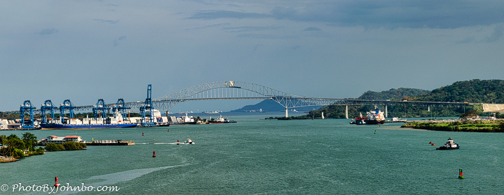
Panama Canal. Upon the completion of the Panama Canal, the world realized that the northern and southern Americas would be permanently split. More importantly, the cities of Colón and Panama City would be separated from the rest of the country. Ferries were used at first, then a couple of other swing bridges provided limited traffic […]
By: Owen Hewitt, TN On May 11, a crack was found in the foundation of the Hernando De Soto bridge during a routine inspection. The crack led to the complete closure of the bridge to traffic, and caused a backlog of ships, as passing under the bridge was also deemed unsafe. The bridge spans the […]
(All information courtesy of Bridgehunter.com and bridgereports.com) Crooked Creek Bridge – built circa 1890. Pony truss bridge over Crooked Creek. West 70th Drive, 0.3 miles east of Alton, Sumner Township. [closed to traffic]. Photo taken by Nick Schmiedeler in December 2017. * * * * * Eagle Creek Bridge – built circa 1910. Pony truss […]
Barby Railroad Bridge in Germany: To be reactivated as a rail line by 2025. Photo: Foto: Störfix, Lizenz: Creative Commons by-sa 3.0 de, CC BY-SA 3.0 DE https://creativecommons.org/licenses/by-sa/3.0/de/deed.en, via Wikimedia Commons
This is not a trestle bridge. In the early 1970s it replaced a 1912 high trestle bridge for the Union Pacific Railroad (which had replaced an even earlier bridge). Abandoned as a railroad bridge in 2003, it is now part of the 25 mile High Trestle Trail in central Iowa. The entrances on either end […]
Crack in the Pier is the reason behind the closure with its future in doubt.
EAU CLAIRE, WISCONSIN- A beloved railroad viaduct spanning the Chippewa River has been closed due to advanced structural deterioration. Its future is in doubt as crews are looking into a pier that has deteriorated beyond repair. The Northwestern Viaduct spans the Chippewa River near the Big Pond site and city dam. It was built in 1880 by the Lassig Bridge and Iron Works Company of Chicago and the Leighton Bridge and Iron Works Company of Rochester, New York- the latter of which was responsible for the bridge’s signature Lattice deck truss design. The bridge has a total length of 890 feet, the largest span is 180 feet. The bridge is considered the highest in the state of Wisconsin, at 82 feet tall above river levels. The bridge used to be operated by Chicago and Northwestern Railroad until it was abandoned in 1991. Excel Energy purchased the bridge from Union Pacific in 2007 to save it from being demolished. In 2015 the bridge opened to pedestrians and cyclists.
Crews on Monday closed down the bridge as they discovered a major crack in one of the limestone piers that was also spalling, thus causing the bridge span to sag. In a statement provided by the City’s media relations:
The High Bridge was initially closed to the public on Monday, June 21, in order to repair a section of railing that was damaged by fallen tree limbs. Meanwhile, a heave had been observed in the bridge deck caused by a crack in one of the piers that supports the bridge. This week an outside Engineer examined the structure and recommended further investigation and repair before re-opening to the public. Since that examination, additional changes in the condition of the bridge have occurred, making this a more urgent situation. Additional fencing and water barriers are being installed to keep boaters, pedestrians, and bicyclists away from the structure for their safety.
The bridge was last inspected in November of last year. City officials and engineers are looking into ways to either repair or replace limestone pier, while at the same time, work to preserve the bridge’s structural integrity. This includes a range of options from making minor repairs, adding additional bracing, encasing the pier or simply removing the affected spans and rebuilding the entire pier from scratch before putting the spans back on. The last option was practiced with the Red Jacket Trail Bridge south of Mankato, Minnesota in 2011 for the exact same reason as the situation being seen with this bridge. When and how the repairs will be made, how long and the costs involved remain open at the time of this press release. The structure is considered a nationally significant monument not only because of its history but because it is the only bridge of its kind left in the country- a quintangular Lattice truss bridge.
Eau Claire is considered the city of bridges but ist main attraction is the one currently receiving (inter)national attention but for the wrong reasons. It is hoped that there is solution to this problem that will not alter the bridge’s integrity, but at the same time, make the crossing safer for people wishing to enjoy the view oft he city, ist bridges and the areas along the Chippewa.
The Chronicles will keep you posted on the latest. Check out the tour guide in the Bridges of Eau Claire, which was created in 2012. Photos and places of recommendation courtesy of fellow pontist, John Marvig. Click here and enjoy the tour.
This is a blog about my project of visiting every bridge over the Genesee River and what I learned about the history, structure, and natural surroundings of each bridge.