Mystery Bridge Nr. 72: A Concrete Camelback Bridge Near Altenburg, Germany

IMGP1432 - Kopie

bhc forum new

Concrete camelback bridges- one of the rarest but most valuable landmarks in bridge engineering. Developed by C.V. Dewart in the state of Michigan in the 1910s, this bridge type is technically a pony or through girder bridge made of concrete, but instead of straight, rectangular railings, these bridges are characterized by their top curved railing with art deco design. Many of them feature an open spandrel design, similar to a concrete deck arch bridge, but as a through girder design. Technically known as the concrete curved chord through girder bridge, these bridges are most commonly found in the state of Michigan, where Dewart designed and built hundreds of them between 1922 and 1928. 34 are known to exist today, Four of which have been re-comissioned for trail use. Most of them had a measure of between 40 and 90 feet. Only one through girder with an overhead chord is known to exist, which is the Pine Island Drive Bridge in Kent County as well as a multiple-span one at Mottville in St. Joseph County, which has been repurposed for recreational use. A small number of these camelback bridges have been found in Ohio, Pennsylvania, California, Indiana and Texas, but in locations that are scattered and are difficult to find and photograph.
Even rarer are the camelback bridges that are built in Europe, for apart from a wider variety of arch, truss and cantilever bridges that were built (and rebuilt) over the course of three centuries, there are only a handful that are left that have been sitting in service, unknown and unappreciated in its beauty. The Mockern Bridge, spanning the Pleisse River near Altenburg in the German state of Thruringia is one of those bridges that belongs to the category of the rare and unknown.
This bridge is easy to find, as it carries a local road connecting the village of Mockern and nearby Padiz, approximately seven kilometers (3.5 miles) south of Altenburg. When travelling north on Highway B 93, it is the last street on the right when leaving Mockern. One can even see it clearly from the S-Bahn line connecting Zwickau and Leipzig via Altenburg and Gößnitz, which was the reason for my visiting the bridge. I had seen the bridge during a trip to Altenburg for a bridgehunting tour back in July and decided to stop there while completing an 80 kilometer tour along the Pleisse from Gößnitz to Leipzig Central Station most recently.

IMGP1425 - Kopie

The bridge is easily reached after going through two curves accompanied by street lamps. When crossing the bridge, the width is typical of American camelbacks- approximately 5 meters (or 15 feet wide) with a weight limit of 10 tons. The features of the bridge is typical of the camelbacks built in Pennsylvania: curved upper chord with vertical, silo-shaped endposts on each end. The railings have a molded spandrel shape paneling on the outside with the center panel featuring a circular shaped medallion with a cross-shape. With the center-most panel, the bridge has a total of seven panels with the total length of no more than 20-25 meters (60-75 feet). The inner portion of the paneling has nothing, but cracks that have appeared and are spalling. Judging by the appearance of the bridge, it appears that the structure has been built between 1915 and 1920 and has not been rehabilitated since its construction. Surprisingly, given the low number of traffic on the road leading to Mockern from the bridge, the bridge appears to be in good shape, keeping its original form and only having wear and tear and the weather extremities as the causes of age. While engineers in America would consider this bridge functionally obsolete and at the end of its useful life, a trend that is considered absurd by engineers in Europe as well as preservationists and historians on both sides of the Atlantic, this bridge is due for some rehabilitation work to strengthen the structure to ensure that it continues its service for another century.

IMGP1419 - Kopie

The bridge is unique because it follows the camelback features, albeit not based on the Michigan model but those built in Ohio and Pennsylvania. Yet it is unknown who was behind the construction of the structure. Was it one who was related to Dewart? Was it one who developed and patent a design similar to Dewart’s and brought it over to the States for use in the Rust Belt? Or perhaps it was the opposite way around: an engineer learned from Dewart or another engineer and decided to use it in this small village in the extreme eastern part of Thuringia? In either case, no known records of the bridge have been found as of yet, which leads to your help in solving this case. What do you know about this bridge regarding its history? Who was behind the construction? If you have any clues, feel free to comment or use this form to send it to the author at the Chronicles.

Altenburg and the surrounding area was one treasure that the author found by accident recently. This goes well beyond this jewel found along the way. More on that soon when a tour guide on the bridges in and around Altenburg will be presented. Stay tuned!

IMGP1426 - Kopie

Author’s Note: Nathan Holth produced an article about the camelback girder bridges for his website. More on that is available by clicking here. Many thanks to him for all his work on this topic. He may have some more bridge examples to come but from an unknown place across the Ocean. 🙂

bhc logo short new

Showdown at Fehmarn

IMGP0759
The Beltretter Petition Drive at the Burg Market Square. Photo taken in August 2016

bhc newsflyer new   Co-produced with sister column, The Flensburg Files

Petition Drive to Stop the Construction of the Tunnel at Puttgarden in Full Gear; Discussion about the Fehmarn Bridge’s Future is on.

BURG/ FEHMARN- For the second time in three years, I had a chance to take a trip to the German Island of Fehmarn, located between Denmark and the state of Schleswig-Holstein, connected by the Migratory Route Highway connecting Copenhagen and Hamburg. Astonished by its beauty and the hospitality the people there gave us our last time, for my family and me, which also includes a friend of ours and her daughter, Fehmarn appears to be the place to go to relax, swim, run along the coast with the wind in our faces and bike to our favorite places for fish with fried potatoes Holstein style.

Yet on this trip it was totally different. Different in a way that the inhabitants of the island are divided over a mega-project that is coming to cross the island- the noise that is comparable to the noise one see along the Migratory Route, which seemed to have increased since our last visit. When visiting the state of Schleswig-Holstein, especially in the eastern part, one will see a blue X every second house along with its slogan, a Christmas light set depicting the Fehmarn Bridge at every fourth house, and this van with the Belt Retter slogan on there, lined up with hundreds of people talking to representatives of the group fighting to stop the project from happening, and signing petitions in the process.  The scene is getting brighter and bluer as the weeks come along….

…..and for a good reason!

Since my visit in 2014, I’ve been covering the events on Fehmarn, which involved not only the island’s future, but also that of the Fehmarn Bridge. To recap on the situation, the Danish Government have been cooperating with the German authorities regarding the construction of the multi-track/lane tunnel connecting Puttgarden (GER) and Rodby (DK), thus eliminating the need for ferry service. The tunnel would feature two tracks accomodating long-distance trains as well as six lanes of motorway traffic, creating a total width of one kilometer including the property acquisitions. At 20 km, it would be touted as the longest tunnel in the world that would serve automobile traffic. At the same time, German government authorities in Berlin and Kiel as well as the German Railways are working together for a new bridge on the south end, spanning the Fehmarn Sound- replacing the island’s iconic span which is the first of its kind ever built.  At the moment, transportation authorities have deemed the 1963 bridge to be functionally obsolete and at the end of its useful life. According to the latest reports from LN-News in Luebeck, planning is in the works to have a new iconic span resembling the Golden Gate Bridge to be discussed and possibly voted on. If approved, construction could start in 2018 and be finished in 10 years.

The current situation during the visit:

The Belt Retter movement has been gaining steam in the past weeks, with organizers and supporters collecting signatures and letters of petitions in much of Schleswig-Holstein- in particular, the eastern half and of course, Fehmarn Island itself. Tens of thousands of signatures have been collected online, as well as in person at the markets and other events. I was lucky to stop at the Belt Retter site at the market square in Burg during our visit to talk to the representatives there, and get some information on the latest with the Puttgarden-Rodby Tunnel (aka Belt Tunnel). The Danish government, which has been keen on moving forward with the project, had previously rejected an earlier proposal for the tunnel last year because of approximately 249 errors in the design and concept, according to officials of the organisation I talked to at the market. After reworking the project, a new proposal was submitted back in June by the coordinators of the project, LBV Luebeck and Femmern A/S, and now the clock is ticking on the part of the locals, the Belt Retter organisation and all other parties opposed to the plan, who had previously petitioned to stop the first draft and succeeded last year. Between now and August 26th, you have an opportunity to submit your petition online or through contact with the representatives of Belt Retter, who will then forward that onto a committee that will feature representatives of the tunnel project, environmental and legal experts, local, regional and state representatives and others involved with the project, who will review it and take further measures. Possible legal measures, such as lawsuits and court order injunctions are on the table should it become a necessity.

Attempts are also being made regarding ways to preserve the Fehmarn Bridge. Rehabilitating the bridge for continual use has been ruled out because of the cost intensitity, but also because it is predicted that the bridge’s lifespan would be prolonged by only 30 years. However, such rehabilitation techniques have been tried on several bridges made of steel, including the steel wiring that is also found on the Fehmarn Bridge. The findings: such rehabilitation can prolong the life of a bridge by up to a century, counting maintenance and other essentials. Already done was the Bay Bridge and (also) the Golden Gate Bridge in San Francisco, this is also being conducted on the George Washington Bridge in New York City, built in 1938 under Swiss Engineer Othmar H. Ammann. Crying wolf over the potential failure of the bridge, as was stated by authorities of the government in Berlin and the German railways, the issues of rust, especially seen by the author while revisiting the bridge this year is only minor. Bridge rehabilitation experts would also agree that rehabilitation would be cost effective, saving taxpayer money by up to half the cost for a new bridge. In other words, and as I signed my petition against the project, I even noted, the movement to stop this mega-project with the tunnel should also include rehabilitating the Fehmarn Bridge.

Opinions are split down the middle among those who are vehemently against the project because of the negative environmental and economic impact as well as those involving tourism and culture and those who are in favor because of the need to modernize the infrastructure and bring in more tourism. It can even be found with the two different stickers at a souvenir shop at Suedstrand in Burgtiefe with the blue X and green check marks, the latter being for the project. Protests from different factors, including the Scandlines (which operates the ferry between Puttgarden and Rodby) have increased loudly in numbers, opposing the entire project. While those supporting the project say that it is a necessity and will come anyway, the Danes are becoming more and more sceptical of the tunnel concept because of the exploding costs for surveys, legal issues and the redesigning of the system. Many have joined the movement on the German side, which has increased tremendously since my last visit.  While it is expected that the construction of the tunnel is to begin in 2020 and last 10 years, should the petition become a success for the second time, it might derail the entire project, putting it on ice indefinitely.

And with that, hopefully in the eyes of locals and people attached to Fehmarn, a return to normalcy which includes accessing the island by two-lane traffic or ferry, coaxing passers-by into stopping on the island for a visit and vacation. This is something you cannot do with a mega-project that would cut the island into two if proponents have their way.

Do you want to stop the project, click here to read the information and sign the petition. Contact details are available if you need further information. The information is in German, but you can talk to someone with English or Danish knowledge if you have any questions. It takes 2-4 minutes to do and consists of multiple choice questions that are user friendly.  If you’re still not convinced that the project cannot be stopped, go to the wordpress version of the Flensburg Files. There, you can click on the gallery with pics of the places visited this year with some comments on my part.

Checkout the articles written about the Fehmarn Bridge Situation including the bridge, by clicking here, here and here.

Beltretter_Logo_FINAL-URL_JPG_square  bhc logo short new FF new logo1

Experience and Common Sense Are Key

13923348_1154422041267767_5276371517232791157_o

bhc interview new The Bridgehunter’s Chronicles interviews an experienced truck driver and talks about bridges, GPS, and self-responsibility on the highway. 

This article starts off with a quote by former Temple men’s basketball coach John Chaney, who lectured a rowdy crowd during a basketball game in 2005, in response to someone throwing an object onto the court, by saying these words: “Stupid is forever. You can’t change stupidity.”  Yet stupidity can be changed; it depends on whether the person does it himself or if it is done for him- in almost every case, with consequences.

Truck drivers ignoring weight limits and height restrictions on bridges and underpasses have been a major problem in the past 10+ years, as incidents like the one in the video below have been in the news once every two days…..

And since the incident that involved the Gospel Street Bridge in Paoli, Indiana in December 2015, discussions as to how competent the truck driver was, let alone what the bridge’s future holds have flared up among networks of pontists, engineers, historians and even truckers alike.

But how would a driver react to the situation where, regardless of the dependency on the GPS, he/she ends up in the situation as Mary Lambright was in, when she disregarded the signs as seen by a pic below and made that fateful crossing?

41618-001
Photo taken by James Baughn

In response to a question posed to one trucker, his response was simple: “If you ever get in a situation where you need to turn around and can’t, you stop, call the local police and put your emergency blinkers on, and wait for assistance to come and help you out of the situation.” In reaction to the incident, Jeremy Johnson’s diagnosis of Ms. Lambright’s will to cross the bridge was simple, “This is a classic example of lack of common sense. First her truck was way too tall to go on this bridge and second, it was far too heavy.” The bridge had a weight limit of six tons and a vertical clearance of 10 feet and six inches at the time of the incident, the former Ms. Lambright later claimed that she didn’t know what six tons meant in pounds. The latter should have served as an alarm signal when approaching the bridge, according to Johnson. “Most trucks have a height of 13’6″. It’s pretty self explanatory that when you see a sign that says 11’6 bridge ahead, you’re not going to make it.”

14012141_1146172122119857_900441096_n
Jeremy Johnson’s semi-truck, idle in the parking lot while its owner is having lunch.

Jeremy Johnson has been in the trucking business for many years, having first driven for a local brewery after obtaining his CDL trucking license in 1998. After a short hiatus, he went into the trucking business full time in 2003, having worked for the farm industry, hauling livestock for 10 years, before starting his own business in his hometown of Marshall, Minnesota, three years ago. Today, he hauls dried and refrigerated goods all over the country, having seen some of the most unusual places along the way, like the largest stockyard in the country located in Oklahoma, or an underground warehouse in Missouri.

He has also seen some of the incidents on the road which makes him and other truckers both cringe and shake their heads, whether it is a trucker trying to turn around while being stuck in the mud or one cutting off a car driver on an Interstate highway.  “I have seen many things in my 10 years on the road that I guess you could say I’ve been desensitized to a point,” Johnson commented in an interview with the Bridgehunter’s Chronicles.  “I’ve seen a lot of accidents and a lot more near misses.” In terms of a good road relationship between the trucker and the car driver, Johnson adds,  “People in cars do not respect the power of a semi. They will cut you off just to save a split second and risk everyone’s lives in doing so.”

The statistics involving truckers and accidents are alarming and sober. According to a 2014 report released by the Federal Motor Carrier Safety Administration, 52,360 of the accidents on the road in the US involve trucks of all kinds; of which, 48.2% involve a truck with a semi-trailer, the kind Johnson uses for transporting goods. 3,744 of the accidents resulted in a fatality, 62.5% of which come from the rig.  The causes of these accidents have been narrowed down to the top five factors, identified by another report: driver fatigue, improper maintenance of the vehicles involved, improper loading of goods, distracted driving and lastly, inexperience. While the US government is working on a plan of regulating the amount of hours of driving on the road and governing the speed limit of semi-trucks on the highway, following examples set in Europe, much of the accidents can be avoided by experience and common sense, something Johnson says is the bread and butter of truck driving:  “There is no such thing as a great truck driver, but there is experience. Experience prepares you for the unexpected situations.”  But experience requires a driver to be fully equipped with knowledge of your truck and having the basic necessities needed to ensure that accidents like what happened at the Paoli Bridge can be avoided.

Most semi-trucks have trailers with a height of 13.5 feet, according to Johnson.  Therefore it is important to know the truck’s height and weight before departing to deliver the next goods somewhere. Even more important is to have a proper GPS device, suitable for trucks,  to ensure that the truck stays on the highway. “The GPS will sometimes route you on a non-truck route if you don’t have a truck-routed GPS system,” says Johnson. And what would be the best GPS system to use while trucking on the highway?

“I personally have a Rand-McNally truck GPS which gives me truck route only maps.” But that’s not all that he uses: “I also use my i-pad with Google Maps to have a general idea where I’m going,” Johnson adds.  It is unknown whether Lambright had a functioning GPS device in her possession at the time of the accident, but reports indicated that she had missed her turnoff as she was entering Paoli and continued travelling on the least travelled Gospel Street with her cousin, driving past the warning signs of the bridge and crossing the structure before it gave way.

The Gospel Bridge was located one block west of another crossing that was suitable for truck traffic, thus leading to the question of why the bridge was even open to traffic, in addition to the issues of fatigue and lack of essential equipment that Lambright might have had while travelling. Many engineers and transportation officials have tried to accomodate truckers by eliminating crossings like this, as well as  the Niland Corner junction at Colo, Iowa. Yet despite the attempt to give truckers the most efficient route, such projects come at a price where places not meant for truck crossings are converted into unnecessary freeway interchanges, losing not just a piece of history but also a piece of life, if a fatal accident occurs.

Speaking from a trucker’s point of view, Johnson believes that the most travelled highways suitable for trucks should be made trucker friendly whereas less-travelled highways and bridges should be left as is. “There are bridges that were built that just weren’t made for trucks, but there are truck routes in every single city and originally they were built for trucks.” He adds, “In my opinion, if a new bridge is going up then you need to make it suitable for present and future traffic and try to think ahead, but for existing bridges not made for trucks, I think they should just leave them alone.” Looking at the Niland Corner Bridge, opposition to the proposal has gone up sporatically but for a good reason: The Jefferson Highway (US Hwy. 65) runs parallel to Interstate 35, which is 10 miles to the west!

Inspite of all the accomodation attempts, the bottom line when trucking on the highway and crossing bridges are two things: common sense and experience. The more experience on the highway, the more the person will learn. Sometimes it takes some shadow training to see if the job fits like a glove, as Johnson pointed out. “In my opinion if you want to become a truck driver, then ride along with one for a month. The only way you get better is through experience.”  And in the end, if one is dedicated, experience will reap rewards as a trucker. “I learn something new out here every week. When you think you know it all its time to retire,” Johnson adds.

While Lambright lost her job, and the trucking company she worked for, based in Louisville, Kentucky, closed its doors right after the collapse of the bridge in Paoli, she still intends on returning to her career as a trucker as soon as she climbs out of her legal holes she is facing at present, which includes fines, suspension of her trucking license and possible jail time. Still, at the age of 23 years, she will need more lessons for the road, on top of what she learned from her experience at the bridge. One of the things that is important, as Johnson mentioned in the interview, is that “….people have very short memories, they forget that trucks bring them everything and I mean everything that a person uses and makes people’s lives more convenient on an everyday basis.” In other words, a trucker’s job is a privilege to be handled by those who are well-equipped with experience and common sense to deliver from point A to point B without the cost of life and property!

13975305_1154426544600650_4642515288250256550_o

Author’s Note:

  1. Thanks to Jeremy Johnson for his help in answering my questions for the article. He and I knew each other from our days at Marshall High School, playing football and basketball together before I moved to another town to finish high school. He graduated in 1996, the same year I did. 
  2. There is still no word on whether and how the Gospel Street Bridge will be rebuilt. Orange County estimates that the cost for the project will be over $1 million. The community is still set on seeing the bridge rebuilt to its original form because of its popularity in the community. More on the bridge’s future will follow.
  3. The photos of the collapsed Gospel Street Bridge are all courtesy of Greg McDuffee, who visited the bridge recently. A big thanks to him for allowing use for this article.

bhc logo short new


Mystery Bridge Nr. 71: The Two Rivers Golf Course Bridge in Sioux City, Iowa

Photos courtesy of IaDOT Archives and HistoricBridges.org

After a brief history of the Bonnie Doon Railroad and its main crossing over the Rock River in Lyon County, the next mystery bridge takes us down the Big Sioux River to its last original crossing, before the coming of the Interstate Highway era, until its confluence with the Missouri River. The Three Corner’s Bridge is located at the site of the Two Rivers Golf Course in Sioux River, spanning the river at the Iowa/ South Dakota border, approximately two miles west of the point where the two rivers merge, as well as the two states and Nebraska meet. The crossing used to be located north of the last physical crossing before its junction, the I-29 bridge, which has been serving traffic since the mid-1950s. It is most likely that the crossing is at the place where a pedestrian crossing, which provides access to the golf course, is located. Yet more information is needed to either support or counter these claims.

But before going into the debate on this structure’s actual location, let’s have a look at the bridge itself. The structure that used to exist appeared to have two different truss bridges built from two different time periods. What is clear is the truss span on the right appears to be much older- having been built in the 1880s and consisting of a pin-connected through truss bridge with V-laced end-posts and an X-frame portal bracings with curved heels. The diagonal beams appear to be much thinner than the vertical beams, this leading to the question of whether the former were built using thin iron beams or with steel wiring. In addition, the design of the bridge leads to the question of its stability, which leads to the question of whether the bridge collapsed under weight or by flooding and was replaced by the span on the left, a Parker through truss span, made of steel, with pinned connections, A-frame portal bracings and featuring beams that are thicker and sturdier. The span on the right, which appeared to be an all-iron structure, had at least two spans total- one of which spanned the main river channel and was replaced by the Parker span. The Parker span was one that is typical of many Parker spans along the Big Sioux River, having been built between 1900 and 1915 by the likes of Western Bridge Company of Lincoln, Nebraska, Clinton Bridge Company of Clinton, Iowa, and the bridge builders from the Minneapolis School of Bridge Builders- namely Commodore P. Jones, Alexander Bayne, as well as Seth and William S. Hewett.  However, it does not mean that the Parker span replaced the lost iron span during that time. It is possible that it was put in place between the 1930s and 1950s, which was the time when bridges were relocated and reused as replacements because of the scarcity of steel on the count of the Great Depression, followed by the onset of World War II and later, the Korea War. With flooding that occurred during the 1940s, especially in 1945-6, it it possible that the Parker was relocated to the spot because of that. Records have already indicated multiple bridge replacements in that fashion, including those in Crawford, Harrison and Monona Counties in Iowa. It is unknown when the entire bridge was removed, but chances are because of the increase in urban development combined with the creation of the golf course, the bridge was removed  between the 1960s and early 1980s.

To sum up, the bridge is very unique but has a lot of missing pieces in the puzzle, which if assembled thanks to help from people like you, can round off the story of the structure that contributed to the development of Sioux City’s infrastructure. What do you know about this bridge in terms of:

  1. The date of construction of both the iron Pratt and steel Parker structures
  2. The bridge builders for both structures
  3. When the iron bridge collapsed and how
  4. Whether the Parker span was original or if it was brought in from somehwere and
  5. If it was relocated, from where exactly and how was it transported
  6. The dimensions of the bridge and lastly,
  7. When was it taken down and why.

Use the question form below and see if you can help put the pieces together. You can also comment on the Chronicles’ facebook pages and encourage others to paricipate. Let’s see what we can put together regarding this bridge, shall we?

bhc fast facts new

The bridge is pinpointed at a location where another truss bridge, a continuous Warren through truss, is located. This one is open to pedesrians accessing the golf course. If you know about this bridge, please feel free to add that to the comment section as well.

The I-29 Bridge was originally built in the early 1950s to accomodate traffic over the Big Sioux River enroute to Sioux City. The bridge collapsed in 1962 due to structural failure and flooding and was subsequentially replaced with a steel beam structure a year later. An additional span was added to accomodate southbound traffic.

bhc logo short new

Mystery Bridge Nr. 70: Bonnie Doon’s Crossing

Photo taken by John Marvig

Our 70th mystery bridge keeps us in Iowa but takes us almost to the other corner of the land of corn and farming, namely Lyon County and in particular, this bridge. While doing some research on bridges in the county many years ago at the Lyon County Historical Society in Rock Rapids, I came across a photo of a through truss bridge, whose span collapsed on one end. My first speculation was that the bridge had spanned the Big Sioux River at the Hidden Bridge Wildlife Area, located seven miles west south west of Larchwood and five miles west of West Central Lyon Schools. The reason behind the speculation apart from the name was because of the roads that led to the river, even though the structure had been removed decades before.

Fast forward to December 2014, when fellow pontist John Marvig visited this bridge, and one can see that the previous assumption was proven wrong. The bridge still stands, but with two spans- both being riveted Pratt overheads with A-frame portals, built using Iowa highway standards- but one of them still broken down and in the Rock River. The bridge is located on what is left of Grant Avenue between the communities of Doon and Lakewood Corner, the latter of which only exists in the history books. Little do the pontists realize is that the now abandoned road and the bridge itself was once part of a legendary railroad that had once traversed through Lyon County but is still talked about today at the museum. That is the Bonnie Doon Railroad.

Owned and operated by the Chicago, Omaha and Pacific Railroad, the railroad line started at Doon, at the junction of the Great Northern Railroad (now owned by BNSF), the line would make an “S-curve” along the Rock River, and after a stop at Lakewood, would cross at this bridge before heading north past farmsteads and cemetaries before stopping at Rock Rapids. A brief description of the trip according to a written account by Galen Lawrence can be found here.  The passenger had the option of taking the line further north to Luverne, which required crossing two tracks running through town. The Bonnie Doon line was in operation for 50+ years until the last train travelled it in 1932-3. The line was never properly maintained and was subject to vandalism and derailments. By 1933, thanks to the coming of the automobile and the expansion of the highway system in the US, the Bonnie Doon line was abandoned with the tracks removed. Some remnants of the line can still be seen today along Grant Avenue as well as in and around Doon, which includes two abandoned culverts, remains of the original crossing here at this bridge and some crossings that could not be removed and had to remain.

It is unknown when this bridge at Lakewood was built in its place, let alone what the original Bonnie Doon crossing looked like. Yet given the introduction of the Iowa highway standards for truss bridges beginning in 1914, the two-span crossing was probably brought in during the 1930s as part of the plan to repurpose parts of the Bonnie Doon Railroad line. Whether it was built from scratch or relocated from another place remains unclear. What is clear is given the somewhat straightness of the road and the nostalgia involving this line and its history, the community of Doon and the township decided to repurpose the railroad as a road for travellers and farmers and provide a wider and safer crossing. It basically served as an alternative to travelling K.T. Highway to Rock Rapids, which is today known as US Hwy. 75. According to the US geographical maps, the road continued its service until the end of the 1960s when the north approached was partially washed away by floodwaters. It is unknown when the southern truss span collapsed partially, but the road and the bridge itself were closed off and abandoned by the early 1980s.

The bridge at Lakewood is a mystery in itself because of its association with the Bonnie Doon rail line and the histories that are being collected, especially with regards to this crossing. We have no idea what the original Bonnie Doon crossing looked like when the trains were in service, let alone when the road trusses were installed to replace the railroad bridge. We do know that the current crossing appears to have retained their structural integrity and could easily be repurposed as a bike trail crossing, even in its original place if one wants to revitalize the line as a bike trail. But given the lack of funding for even bridge replacement in Iowa, that project is, at the most, in the pipeline and it could take years until Bonnie Doon comes alive again for cyclists to use.

Do you know more about this bridge? Put your comments in the section below, post them on the Chronicles’ facebook page or send them to Jason Smith at the Chronicles. Information will be updated as they come in.


bhc fast facts new

Rock Rapids was the central hub for railroads between 1880 and 1930 with three railroads passing through the community of 2,300 residents. Apart from the Omaha Railroad, another north-south line passing through was the Illinois Central, which connected Orange City and Sioux Falls, stopping at George, Edna and Beaver Creek (MN). The Rock Island Railroad was the lone east-west line going through Rock Rapids, connecting Sioux Falls with Estherville, stopping at Little Rock, Larchwood, Lester and Granite. Each one had a bridge crossing the Rock River. After the ceasement of the Bonnie Doon Line, the Rock Island abandoned its line through Rock Rapids in 1972 and eventually went bankrupt in 1980. The Island Park Viaduct, located east of the Historical Society and was part of the Rock Island line was converted to a bike and pedestrian crossing in 2008. The Illinois Central line was abandoned in 1981, but its crossing is still being used by the local public works facility. Eventually it too will become a bike trail crossing because of its proximity to a nearby park.


The Chronicles would like to thank John Marvig for discovering this bridge and bringing the topic on Bonnie Doon back to life. 


bhc logo short new

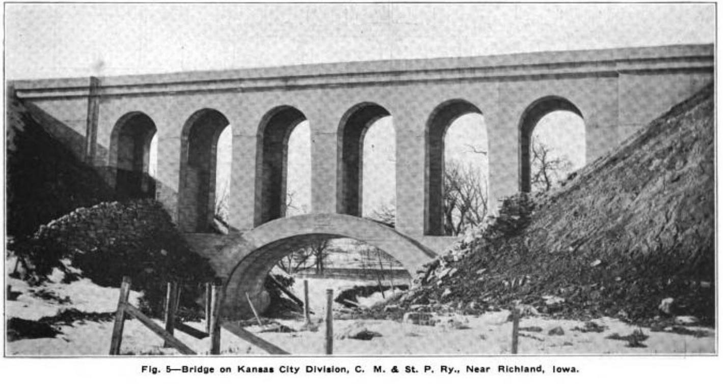
Mystery Bridge Nr. 69: H.E. Dudley and His Bridge Near Richland, Iowa

Archive Photo courtesy of Luke Harden

bhc forum new

No one has really known about a bridge builder that existed in Iowa for over a century ago by the name of H.E. Dudley. In fact when researching about his history, only a handful of his names emerged which would make sense- namely, a Dudley that existed between 1870 and 1920. But then again, we don’t know if his bridge building business originated from Iowa or from outside. We just know two variables that confirm of his presence in bridge building and they are located in Marshall County- at Hoy Bridge

Photo taken by John Marvig

Located three miles southwest of Rhodes and three miles north of Hwy. 330, this bridge was constructed by Dudley in 1912 for the Chicago, Milwaukee and St. Paul Railroad (aka The Milwaukee Road) connecting Marshalltown and Des Moines. Train traffic used this bridge for 70 years until the Milwaukee Road abandoned it in 1982 as part of the plan to cut its rail lines and save its company. The railroad eventually became part of Canadian Pacific through a series of mergers and consolidations. The 212 foot arch viaduct, whose towering height of 60 feet is covered wit vegetation became part of the Heart of America bike trail in 2003, thus revitalizing the network that had been abandoned for 20 years.

Going back to this mystery bridge at Richland, fellow pontist Luke Harden brought the photo to the attention of the Chronicles recently. The design is similar to that of the Hoy Bridge- six spans of concrete arches supported by another arch bridge, located over a small creek near the town of Richland in Washington County. This means that the work was most likely that of Dudley’s. The bridge was built to serve the Milwaukee Railroad. The question is when it was built, but even more importantly: where the bridge was located!

Richland is served with one railroad going through the community of 350 inhabitants and has a creek flowing north and west (Richland Creek). When using Bing, one can see two crossings to the south and west of Richland. Neither of which would fit the estimated length of between 200 and 270 feet the bridge would have. Sources had indicated that the bridge would be located to the southwest of Richland. Going southwest, the crossings appear to be a trestle with half the length and a multiple span plate girder bridge with a length of 150 feet. Unless the Dudley arch viaduct was removed and replaced with this span, neither crossing seemed to fit.

Tracing the rail line going northeast, there are several crossings along the creek, even going past the next community of Rubio. However all of them have a span of up to 75-100 feet total. This would refut claims made by another pontist that the bridge is/was northeast of Richland. However, recent discoveries might pinpoint this structure over a creek between Fir and Gingko Avenues northeast of Rubio, five miles east of the Skunk River Bridge. Looking at the map carefully, one can see a trough and a sizeably large creek which is crossed by a long bridge. Covered in massive vegetation, it is difficult to tell whether this crossing is indeed the Dudley bridge we are looking for. One would need to wait until the winter for a photographer to walk the railroad track and get a close-up of the bridge to confirm. The line is still operated by Iowa, Chicago and Eastern Railroad, despite being owned by seven different companies over the past three decades. Should a person happen to be at this crossing, he/she is due for a surprise, whether the bridge matches the black and white photo or not.

Little is known about this bridge, let alone H.E. Dudley and his work as a bridge builder, let alone his affiliation with the Milwaukee Road. While research is being conducted at the time of this press release, the Chronicles needs your help. What we would like to know about is when and where he lived, how long did he build bridges in his lifetime, where was his bridge building business located, and lastly, how many other bridges were credited to his name and where were they located? This is in addition to determining whether and where the Richland Viaduct is located exactly- whether it is still extant or if it has been replaced. Your thoughts on the Richland Bridge and/or H.E. Dudley? Please use the contact form and provide the author with some information that will be useful. Eventually if there is sufficient information, an article on Dudley’s life and works will be put together to provide the readers with an overview of this rather unknown bridge builder, whose two bridges (so far) have contributed a great deal to the Milwaukee Road and the history of America’s infrasturcture.

Map with the possible locations of Dudley’s Richland Bridge can be accessed here.


bhc logo short new


Wengelsdorf Bridge in Saxony-Anhalt Coming Down

Photo taken in 2011
Photo taken in 2011

bhc newsflyer new

Century-old railroad overpass spanning the rail lines between Leipzig/Halle and Naumburg (Saale) being demolished after sitting idle for almost three decades.

GROSSKORBETHA/BAD DURRENBERG/LEIPZIG-  Travellers passing through the German states of Saxony and Saxony-Anhalt by train have been seeing a lot of construction on the rail lines, lately. As part of the modernization process, overhead electrical lines that provide power to trains are being replaced because of age, tracks are being replaced or added, train stations are being rebuilt and unused bridges are being taken down. The Wengelsdorf Bridge at Grosskorbetha is one of the bridges that has fallen victim to progress. Sitting idle since 1990, the 1910 structure, which was rehabilitated and extended in 1945 and used to connect the villages of Wengelsdorf and Grosskorbetha, is coming down in pieces. Already gone is the larger half featuring the signature arch spans over the rail line going to Leipzig, work is being done to replace the line going to Halle (Saale) as this article is being posted. The city council in Weissenfels and the German Railways (Deutsche Bahn)  in 2013 agreed to provide 1.4 million Euros ($2.1 million) to remove the 150-meter long structure, which belongs to the Bahn, as the bridge had become a hindrance to train service and it no longer was deemed useful. The demolition is part of the plan by the Bahn to modernize the railroad yard and junction at Grosskorbetha, which include new tracks and overhead lines, both of which are at least 50 years old. While the project is expected to be completed by 2018, the bridge is expected to be gone by the end of August of this year.  By that time, the construction year, already touted as the worst in the history of the Deutsche Bahn with several major projects and railroad detours, will have reached its end, and passengers will be able to breathe a sigh of relief as they commute between work and home- without the delays and other complications.

As for the Wengelsdorf Bridge, a Mystery Bridge in itself, what will be left behind is history that will be discovered in books and through oral sources.

Check out the mystery bridge article on this bridge here.

ALSO: Try your luck on Saxony-Anhalt with a quiz, provided by sister column The Flensburg Files, which you can click here. Answer sheet is provided via link.

bhc logo short new