Located along the River White Elster in eastern Saxony-Anhalt, the city of Zeitz, with ist population of 29,000 inhabitants, represents one oft he dying cities in the former East Germany. High unemployment, empty buildings, abandoned industries and a crumbling infrastructure, combined with historic buildings dating back to the 1800s that are sitting empty are what a person can see when passing through the city. Most of its main traffic has been diverted away from the city, and the only rail service in Zeitz are the lines connecting the city with Weissenfels, Gera and Leipzig- all privately owned and localized.
Yet the city scape of Zeitz has, for the most part been in tact, thus making it the venue for many films produced that require an East German scene or story. Despite their emptiness, many historic buildings in the city center are worth visiting and perhaps occupying with businesses and housing. Even the Moritzburg Castle and the nearby mills and churches, built during the Baroque period, still entertain guests because of their charm. You can also try the local wine from the vineyards located along the rugged Elster Bike Trail.
And then, there are the historic bridges.
At least a dozen bridges exist along the White Elster within a 10 km radius of the city, six of which can be found directly in Zeitz. Two thirds of them are at least 70 years of age or older. Yet all but two of them have been mentioned in the history books or by the International Structure Database in Berlin (structurae.net) which is part of the Wiley and Sons Publishing Conglomerate. While much of the records have disappeared because of World War II and later the Socialist regime, the structures profiled here are unique in its design and historic value. Most of the bridges are arches, but there are a couple girders and trusses that are worth mentioning as well. Each one lacks the most basic in terms of the date of the builders, their dimensions and for the most part, the stories behind them and their affiliation with the communities and castles they serve. Henceforth, this tour will profile each of the bridges in and around the Zeitz area, starting with the bridges near Crossen to the south and ending at Elsterau to the north. All but three of the bridges profiled in this tour guide are along the Elster. One of the bridges, the Moritzburg Pavillion Bridge, has already been profiled separately in a Mystery Bridge article and will therefore be omitted from this article. A link to this bridge can be found here.
A map of the bridges can be found via Google Map, by clicking here:
The rest of the tour of the historic bridges conducted most recently by the author you can click on the Chronicles’ symbol, which will lead you to the website and the tour in its entirety:
Located along the River White Elster in eastern Saxony-Anhalt, the city of Zeitz, with ist population of 29,000 inhabitants, represents one oft he dying cities in the former East Germany. High unemployment, empty buildings, abandoned industries and a crumbling infrastructure, combined with historic buildings dating back to the 1800s that are sitting empty are what a person can see when passing through the city. Most of its main traffic has been diverted away from the city, and the only rail service in Zeitz are the lines connecting the city with Weissenfels, Gera and Leipzig- all privately owned and localized.
Yet the city scape of Zeitz has, for the most part been in tact, thus making it the venue for many films produced that require an East German scene or story. Despite their emptiness, many historic buildings in the city center are worth visiting and perhaps occupying with businesses and housing. Even the Moritzburg Castle and the nearby mills and churches, built during the Baroque period, still entertain guests because of their charm. You can also try the local wine from the vineyards located along the rugged Elster Bike Trail.
And then, there are the historic bridges.
At least a dozen bridges exist along the White Elster within a 10 km radius of the city, six of which can be found directly in Zeitz. Two thirds of them are at least 70 years of age or older. Yet all but two of them have been mentioned in the history books or by the International Structure Database in Berlin (structurae.net) which is part of the Wiley and Sons Publishing Conglomerate. While much of the records have disappeared because of World War II and later the Socialist regime, the structures profiled here are unique in its design and historic value. Most of the bridges are arches, but there are a couple girders and trusses that are worth mentioning as well. Each one lacks the most basic in terms of the date of the builders, their dimensions and for the most part, the stories behind them and their affiliation with the communities and castles they serve. Henceforth, this tour will profile each of the bridges in and around the Zeitz area, starting with the bridges near Crossen to the south and ending at Elsterau to the north. All but three of the bridges profiled in this tour guide are along the Elster. One of the bridges, the Moritzburg Pavillion Bridge, has already been profiled separately in a Mystery Bridge article and will therefore be omitted from this article. A link to this bridge can be found here.
We’ll start off with the first of two bridges in the village of Crossen, both of which can be reached by bike:
Rauda Bridge at Crossen:
This bridge spans Rauda Creek, approximately a half kilometer south of the White Elster crossing. The bridge is approximately 15 meters long and six meters wide, good enough for a bike trail. The bridge is a stone arch design that probably dates back to the 1800s, when it was used for horse and buggy, serving a trail between Crossen and Silbitz. Later it was used for farm vehicles, but as the fields nearby are located in the flood plain of the Elste were therefore rendered useless, the trail was eventually converted into the bike trail connecting Crossen and Gera to the south. The bridge still remains in great condition despite its age and is a great place to stop for a picnic or even good photo opportunity, as seen with this photo.
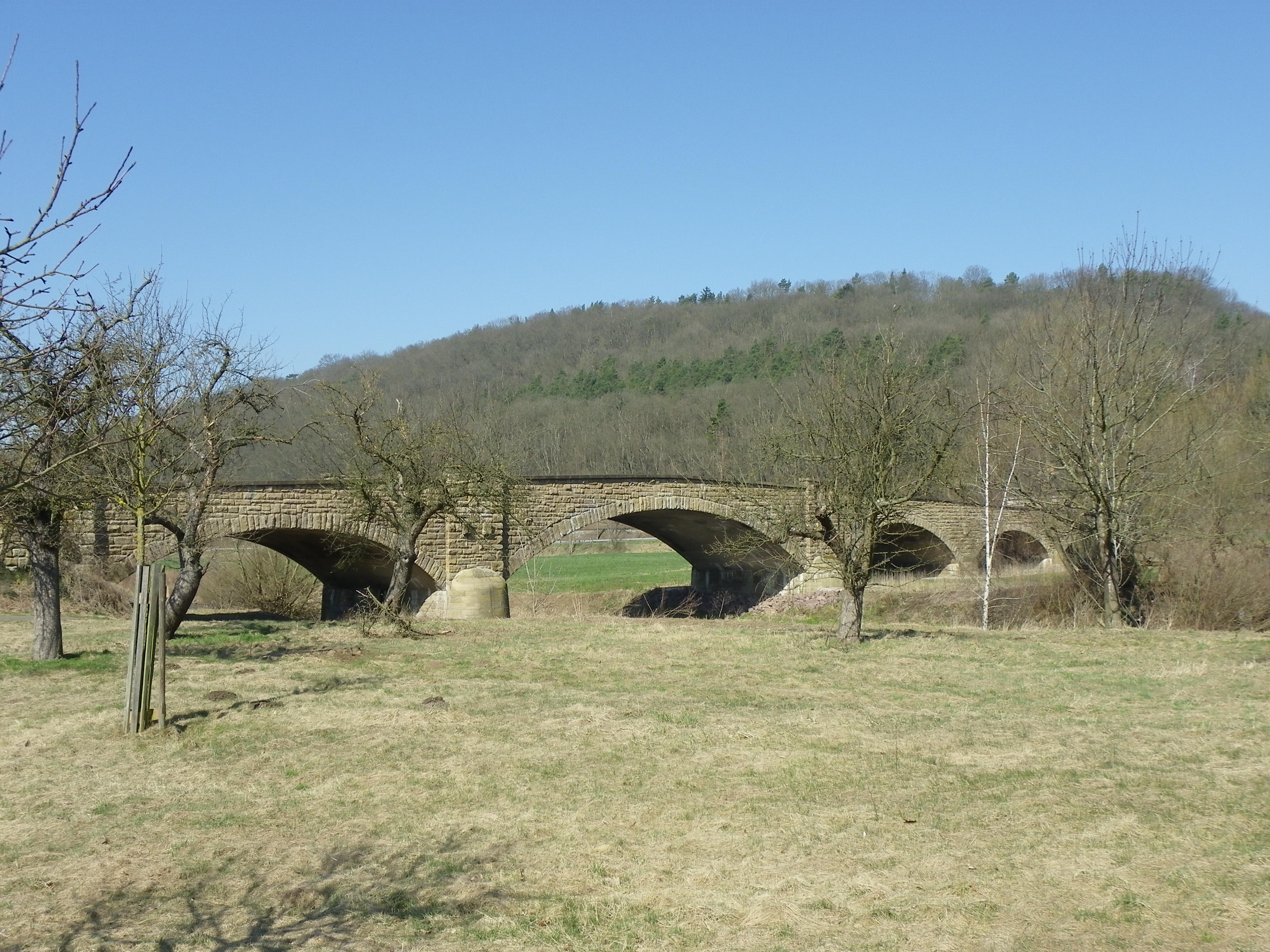
Crossen Bridge:
Spanning the Elster River, the Crossen Bridge features a deck arch bridge made of brick and concrete, and features seven arch spans totalling 130 meters long. The longest arch span (the center span) is approximately 30 meters long. The bridge’s spandrel is all made of concrete, whereby the arches were built of brick. While the bridge has been renovated as recently as 10 years ago, the date of the original construction of the bridge goes back to between 1900 and 1920. Records indicated that an attempt to implode the structure by the Nazis in 1945 in an attempt to stop the march of the Soviet troops only for the local residents to splice the wiring to the bombs in order to sabotage their attempts. The Nazis surrendered on 7 May, 1945 but not before their leader Adolf Hitler and many of his close friends committed suicide in order to avoid prosecution by the Allies. The bridge continued to be in service until recent renovations where sidewalks were added and the roadway was narrowed. Today, the bridge provides only one-way traffic controlled by traffic lights on each end. Yet it has no load limits, thus allowing for all kinds of traffic to cross, as seen in the photos below:
Haynsburg Bridge:
Spanning the White Elster on the road going to Haynsburg Castle to the east, this bridge features five arch spans totalling approximately 200 meters, the longest center arch span is around 50 meters. That span is flanked with two door-like openings on each corner, embedded into the piers, resembling an embedded pavillion on each corner. It is unknown what the original atructure looked like before World War II, but the date of construction goes back to 1911, according to local records. The bridge is one of three works of art one should see while in Haynsburg. The castle is three kilometers up the hill from the bridge. A train station along the rail line between Leipzig and Gera has a decorative lounge, even though trains no longer stop there. Haynsburg itself was a target of a witch hunt, for in 1624, one of the residents was burned at the stake for witchcraft. Since 2010, Haynsburg is part of a local conglomerate that includes two other villages. The town is only a handful that has witnessed steady population growth for it has 580 inhabitants. The bridge itself will be rehabilitated come 2018 with the purpse of improving its load capacity and its aesthetic value.
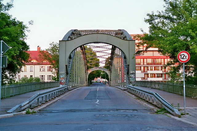
Bahnhofsbrücke:
Spanning the White Elster River, this pedestrian bridge connects the train station with the park complex along the river next to the city center in Zeitz. While travelling along the river along the Elster Bike Trail, this bridge is one of the two most visible structures near the vicinity of the train station. The bridge has a bedstead Pratt pony truss with welded connections. Judging by its aesthetic appearance, the structure appears to be at least 10 years old but no older than 20. It is unknown whether a previous structure had occurred there but because of the prescence of the pavillion across the river from the station, it may be possible that a structure had existed beforehand, but was either destroyed during World War II and was not rebuilt before 1990 or it fell into disarray during the socialist regime and was consequentially removed. But more information is needed to determine whether a previous structure existed prior to this one.
Untere Promenade Bridge:
Located over the Mühlgraben Creek at the confluence with the White Elster, this bridge is located right next to the aforementioned Moritzburg Pavillion Bridge. The bridge serves the Elster Bike Trail but it is unknown when the bridge was built. It would be unusual to have a bridge exist alongside the pavillion bridge for a long period of time, so one must assume the bridge was built after World War II, especially because of the ballustrades that were remodelled. Yet more information is needed to determine whether the bridge was built in modern times to replace the pavillion bridge or if it was built at about the same time, especially as arch bridges were very common up until 1915. The author’s prediction is that the bridge was built to mimick the pavillion bridge in the 1950s or 60s to accomodate a trail running alongside the river. In either case, both bridges retain a high degree of historic and aesthetical value that it is worth stopping to photograph.
Geschwister Scholl Brücke
This is perhaps the most ornamental of the bridges along the White Elster River between Gera and Leipzig, for the 250 meter long seven-span concrete arch bridge provides the best access from the train station to Moritzburg Castle by car. The bridge has stone keystones and seal engravings above the piers. Its ballustrades are similar to the Untere Promenade Bridge and were redone most recently (10-15 years ago). Finials can be found on both ends of the bridge, but more unique and unusual is the lighting on the bridge- only one pair of lanterns are located at the very center of the span, but built on cast iron poles with a unique ornamental design.
Judging by the age of the bridge, it appears to have been built between 1890 and 1915, yet when looking more closely at the structure ‘s center span in comparison with the outer ones, the bridge appeared to have been rebuilt after the war, as the Nazis blew up the center span in an attempt to slow the advancement of Soviet troops. The bridge and street itself were named in honor of Sophie and Frank Scholl, siblings who led the White Rose movement, a group whose purpose was to create an uprising against the Hitler regime. They were arrested and executed in 1944, along with dozens of other members of the movement. Yet the Nazi government ceased to exist with Germany’s surrender on 7 May, 1945. Hitler committed suicide a week prior to the fall.
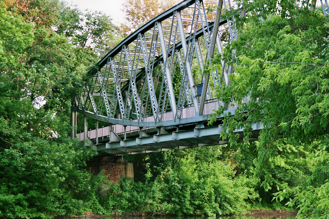
Tiergarten Pedestrian Bridge
Spanning the White Elster east of town, the Tiergarten Pedestrian Bridge is one of the most unique of spans, as the bridge features two Howe spans meeting in the middle. The center of each Howe span is supported by one steel pier but the outer ends are anchored by concrete piers. The truss itself has bedstead end posts and features welded connections. Lighting illuminates the bridge. The bridge appears to be one of the younger spans, being built in the 1990s, but it is located near a small park on the north end of the river. It also serves as the division point for two sections of the trail. The older section of the Elster Bike Trail crosses this bridge before turning left and heading to Tröglitz. A newer portion of the trail does not cross the bridge but continues north past the park towards Massnitz and Zangenberg, tunneling through the forest along the way. Both paths have historic bridges along the way to photograph.
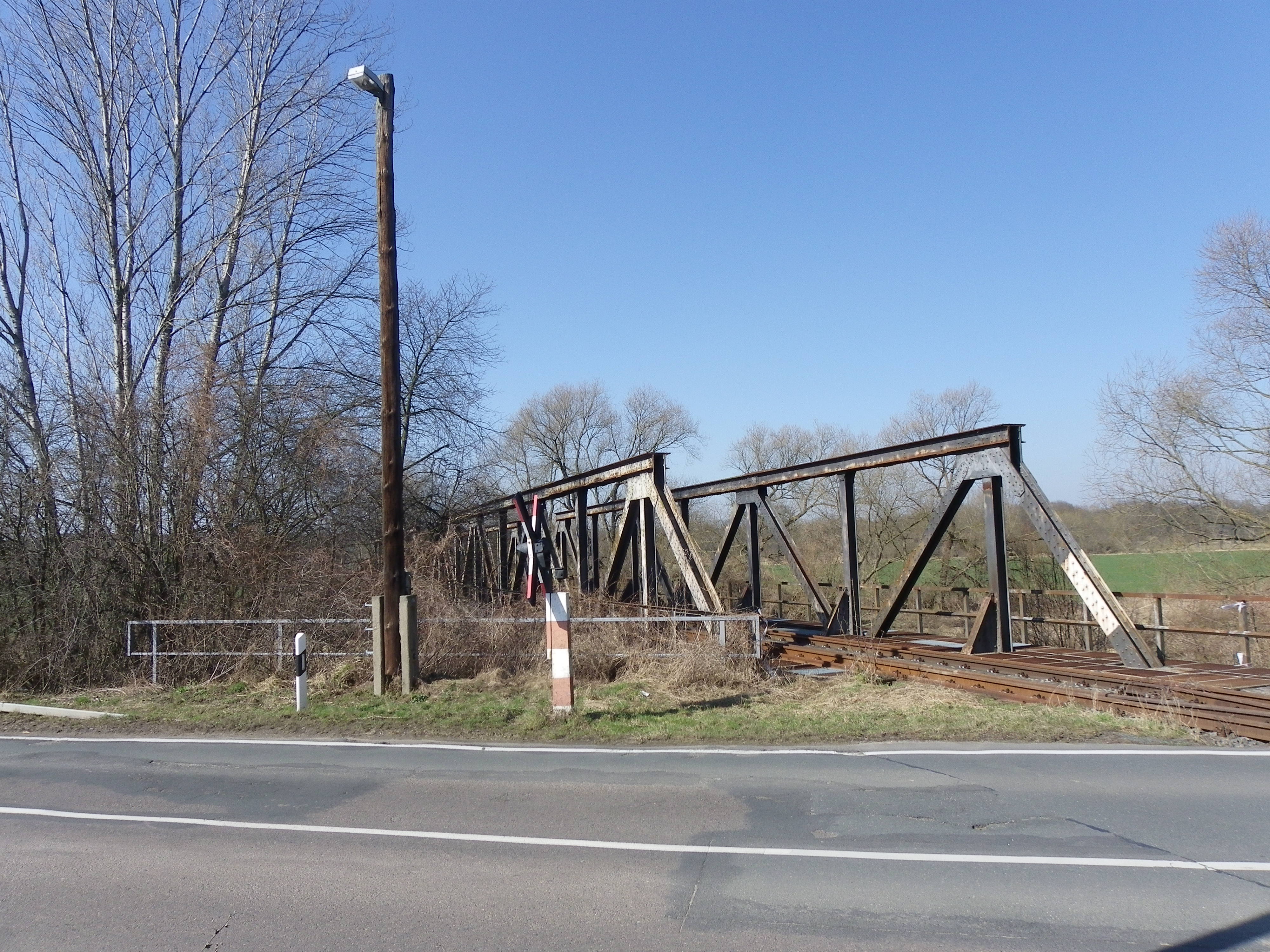
Rehmsdorf Railroad Bridges
Located over the White Elster at the railroad crossing just outside the village of Tröglitz (1 km east of Zeitz), the Rehmsdorf Railroad Bridge features two different bridges. The river crossing, which one can see at the railroad crossing, consists of two Warren pony truss spans with vertical beams and riveted connections. Just 100 meters from that bridge is a deck plate girder bridge with eight spans, spanning a stream that empties into the White Elster. Both bridges, dating back to the 1920s, can be seen from the road connecting Tröglitz to the east and Zeitz to the west, and as the older stretch of the Elster Bike Trail runs parallel to the road, bikers and photographers have the best view of the two bridges with the camera. The bridges once served a rail line connecting Zeitz with Meuselwitz via Tröglitz and Rehmsdorf. Unfortunately, flooding caused the collapse of three of the plate girder spans resulting in the closure of the bridge and the rail line. Most likely the collapse happened during the most recent flooding in 2013. It is unknown whether that bridge will be replaced and the line reopened. But given the availability of bus service in the area, chances of anything happening with the line are slim.
Deck plate girder spansClose-up of the collapsed spans.
Börnitz/ Massnitz Railroad Bridge:
Leaving the Zeitz area and heading north along the White Elster, we have this bridge, located only four kilometers from the one at Tröglitz. Even stranger is the fact that even though it is located near Massnitz and Börnitz, it also served the line that ran in a loop fashion going north from Zeitz, then looping onto this bridge before heading south to join the line that eventually terminates at Meuselwitz. This leads to the question of whether this bridge was the original crossing serving the line between Zeitz and Meuselwitz before it was eventually realigned to go past Tröglitz and replaced by the aforementioned bridge. If that is the case, then when did the replacement take place? The author’s hunch: as this bridge features two concrete arch spans over the river, supported by 10 (approach) spans of steel deck plate girders (summing up the length to about 1 kilometer), and the piers of the approach spans look much newer than the arch spans (which most likely dates back to a time up to 1890), the structure was originally an arch span (probably 10-12 spans counting the two spans over the river). All but the two river spans were blown up (most likely by the Nazis in 1945), and while Soviet troops tried to rebuild this bridge, a temporary bridge at Tröglitz (the one mentioned earlier) was built, which later because its permanent replacement. While more evidence is needed to support this argument, Adolf Hitler’s plan of destroying everything in the path of the Allied troops, known as operation Nero, is known throughout the circle of German historians. Nero was enacted at the dismay of even his closest allies, shortly before his suicide in 1945, but failed when even the locals realized that the war was all lost and sabotaged the attempts of the Nazi soldiers to blow up the bridges. 80% of Germany’s remaining bridges were destroyed as part of the plan, only 10% of them could ever be restored. It is uncertain whether this bridge was one of the 80%, but it would not have been surprising if evidence points to that. In either case, the bridge is accessible via street and bike route connecting Tröglitz and Massnitz on the east side of the river as well as the new Elster Trail between Börnitz and Zeitz.
Close-up of the arch spans. How old do you think they are?The arch spans behind the trees. Photo taken from the newer stretch of the Elster Bike Trail
Göbitz Mühlgraben Bridge:
Located over Mühlgraben Creek just 500 meters from its confluence with the White Elster, this bridge appears to be one of the oldest remaining structures in the Zeitz region. The 25 meter long structure features a trapezoidal style concrete arch bridge, which is typical of bridges built in the 1800s. The bridge may have been built to serve horse and buggy traffic between Börnitz and Göbitz until newer highways diverted it away from this crossing. Although it still serves pedestrian, cyclar and farming traffic today, spalling cracks in the spandrels and the wingwalls show that some structural rehabilitation is needed in order for it to accomodate traffic in the future. Whether or not it will happen remains to be seen.
Elsterau Pedestrian Bridge:
The last bridge profiled on the tour is this crossing. Spanning the White Elster River, this wooden pony arch span serves not only the Elster Bike Trail but also the trails connecting Börnitz and Göbnitz. The bridge was most likely built between 2008 and 2012 for it appears new to the eyes of the tourists. In either case, the bridge serves as a new addition to the village of Börnitz, which is a quiet community with just a handful of shops.
A map of the bridges can be found via Google Map, by clicking here:
To summarize this tour, the bridges in and around Zeitz, most of which are located along the White Elster, represent the charm and historic value that best fits the landscape of the area. These structures have a history of their own, many of which are worth researching, for the information on them are scarce. But as you bike along the Elster Bike Trail, you will find that these structures are worth biking for, even if the trail can be rugged at times. Yet these bridges are only a handful of the structures one should see in neighboring Leipzig (to the north) as well as Gera (to the south). Henceforth, never skip a stop for each one is full of surprises that are worth spending a few minutes of your time for. Zeitz is one of those forgotten examples that should not be forgotten.
The next Mystery Bridge takes us to New Hampshire. We have read and heard of many stories of the Granite State losing dozens of historic bridges because of their being neglected by the local and state governments, including the Boscawen Bridge and this year the Sewall Falls Crossing. We’ve also read about the state priding themselves of their covered bridges, which are both loved and hated at the same time by many pontists.
Yet this mystery bridge brings metal and wood together, not to mention the covered bridge and metal truss bridge lovers. Located over a railroad bridge along Lakeside Avenue between Tower Street and Foster Avenue in Weirs Beach in Belknap County, this bridge presents an unusual truss design that is almost never seen nowadays. The bridge features a metal deck truss design in a shape of a Kingpost built on an incline. The outer portion has a 40° angle, whereas the inner portion has an obtruse triangular shape that is subdivided. Furthermore, the longest diagonal beam between the center span and the pier has a slight bent where the support beam meets. Looking at the trusses more closely, one can see that the connections are riveted, this putting the construction date up to the time after 1900, the time when riveted truss bridges were being introduced and proliferated with the standardization programs introduced by the states’ highway departments.
The covered portion of the bridge in the center span features a pavillion with a half cylindrical roof colored in blue. The roof is supported by four iron piers, one in each corner and that are ornamental at the railing and where the columns meet the roof. The steps appear to be made of wood.
The bridge serves as the entrance to the Winnipesaukee Marketplace, yet it is unknown whether the bridge was built at the same time as the historic building, or if the bridge existed well before that. It is known that this bridge presents some similarities to another bridge in Germany, the Bridge of Friendship at the German-Danish border north of Flensburg, although the trusses for that bridge is not as advanced in appearance as this bridge at Weirs Beach. Plus the roadway of the bridge in Flensburg is straight, unlike the roadway of the New Hampshire bridge and its half-octagonal look. The Bridge of Friendship was built in 1920 and was renovated in 2004.
The Bridge of Friendship at the German-Danish border north of Flensburg. Photo taken in 2011
This leads to the questions of when the bridge at Weirs Beach was constructed- whether it was at the same time as the market place or earlier- and who was the mastermind behind this unique bridge design. Why build it over the railroad tracks when trains passed through on a regular basis 60 years ago and why not build a tunnel underneath? These questions have yet to be solved. Can you help?
Post your thoughts in the comment section here, as well as those in the Chronicle’s facebook pages and the Bridges page, where you can see more photos of the bridge taken by Scott Wagner (who is to be thanked for allowing use of the pics). Your thoughts and stories/history behind the bridge will be much useful in solving this mystery.
Over the holiday season, as I was celebrating with family and getting some photo opportunities of some bridges in Iowa and Minnesota, one of my fellow pontists brought this painting up to the attention of the historic bridge community. It was a sketch of low quality showing a tall suspension bridge, trying to go along the lines of the Golden Gate Bridge but it is unknown whether it is the Golden Girl or the Big Mac Bridge (aka Mackinac Bridge) in Michigan because it was too blurry to tell. To an art teacher, the “artist” portraying this bridge would have received a failing grade for its lack of quality. However, both the teacher as well as a historian would have gotten grey hair and wrinkly had they seen that the title of this “pseudo-drawing” been touted as The Brooklyn Bridge!
I think I feel the tremble of the ground as a result of the Roebling family coming out of their graves for that!
While this person had good intentions of making money, and Wal-mart (where the drawing was spotted) was the place to sell the artwork, little did he realize that with the help of the internet and some photos from books and other sources, he would have found out that there is a stark contrast between the Brooklyn, Mackinac and the Golden Gate Bridges. How stark? The photos below speak for themselves…..
Golden Gate Brifdge. Photo taken by Nathan HolthMackinac Bridge in Michigan. Photo taken by Nathan HolthTransversal view of the Brooklyn Bridge. Photo by Nathan Holth
The problem with this misperception of this drawing is that many people do not know what the bridges look like and will take drawings like this one to mislead them into knowing that it is this bridge, when in all reality the actual appearance is anything but that. Furthermore, both the aforementioned bridges have been seen in books and movies, so the differences between them should be obvious. Yet with our total embrace with electronic games and technology as if we are swimming in a pool of water is causing us to lose sight on our surroundings, let along our basic knowledge of history and other core subjects that they all seem to be placed in the backburner. We become disillusioned to what we see, and the younger the generation, the more likely they will identify with the wrong items and have them stick to a point where it becomes more difficult to unglue.
So in order to avoid this type of misunderstanding and misleading identification, here is a word of advice to give to the next person who attempts to draw or paint a picture of something as iconic as a historic bridge: Get it right the first time!
Look at the photos and films, visualize in your head what it looks like and how it should look on paper, and allow yourself an ample amount of time to do the artwork correctly. And don’t worry about the issues of copyright laws. If you do the artwork differently than the one before that, yours will turn out just as well, if not better.
As Gaudenz Assenza, former professor of political science at the Friedrich Schiller University in Jena, Germany and now professor at the Catholic University of Rozemborok in Slovakia once quoted: Quality trumps quantity in all aspects of life. While this may refer to aspects on the level of academia, it also applies to all aspects in life, especially when it comes to something like artwork. Think about this before putting the lead to the leaf, no matter how you do it.
Over the holiday season, as I was celebrating with family and getting some photo opportunities of some bridges in Iowa and Minnesota, one of my fellow pontists brought this painting up to the attention of the historic bridge community. It was a sketch of low quality showing a tall suspension bridge, trying to go along the lines of the Golden Gate Bridge but it is unknown whether it is the Golden Girl or the Big Mac Bridge (aka Mackinac Bridge) in Michigan because it was too blurry to tell. To an art teacher, the “artist” portraying this bridge would have received a failing grade for its lack of quality. However, both the teacher as well as a historian would have gotten grey hair and wrinkly had they seen that the title of this “pseudo-drawing” been touted as The Brooklyn Bridge!
I think I feel the tremble of the ground as a result of the Roebling family coming out of their graves for that!
While this person had good intentions of making money, and Wal-mart (where the drawing was spotted) was the place to sell the artwork, little did he realize that with the help of the internet and some photos from books and other sources, he would have found out that there is a stark contrast between the Brooklyn, Mackinac and the Golden Gate Bridges. How stark? The photos below speak for themselves…..
Golden Gate Brifdge. Photo taken by Nathan HolthMackinac Bridge in Michigan. Photo taken by Nathan Holth
Transversal view of the Brooklyn Bridge. Photo by Nathan Holth
The problem with this misperception of this drawing is that many people do not know what the bridges look like and will take drawings like this one to mislead them into knowing that it is this bridge, when in all reality the actual appearance is anything but that. Furthermore, both the aforementioned bridges have been seen in books and movies, so the differences between them should be obvious. Yet with our total embrace with electronic games and technology as if we are swimming in a pool of water is causing us to lose sight on our surroundings, let along our basic knowledge of history and other core subjects that they all seem to be placed in the backburner. We become disillusioned to what we see, and the younger the generation, the more likely they will identify with the wrong items and have them stick to a point where it becomes more difficult to unglue.
So in order to avoid this type of misunderstanding and misleading identification, here is a word of advice to give to the next person who attempts to draw or paint a picture of something as iconic as a historic bridge: Get it right the first time!
Look at the photos and films, visualize in your head what it looks like and how it should look on paper, and allow yourself an ample amount of time to do the artwork correctly. And don’t worry about the issues of copyright laws. If you do the artwork differently than the one before that, yours will turn out just as well, if not better.
As Gaudenz Assenza, former professor of political science at the Friedrich Schiller University in Jena, Germany and now professor at the Catholic University of Rozemborok in Slovakia once quoted: Quality trumps quantity in all aspects of life. While this may refer to aspects on the level of academia, it also applies to all aspects in life, especially when it comes to something like artwork. Think about this before putting the lead to the leaf, no matter how you do it.
The Gasconade River in Missouri: once populated with dozens of metal truss bridges loaded with history and charm, the river that flows past Wright, LeClare and Gasconade Counties now only has one bridge left. This bridge, built in 1924, used to carry the Mother Highway from Chicago to Los Angeles, Route 66 (officially, US Hwy. 66). Sadly, this bridge is now the poster boy of how a state, like Missouri, has neglected its bridges, both modern and historic, and does not have the money to even maintain them.
Since December 2014, the Missouri Department of Transportation has closed this key crossing near Hazelgreen, despite its historic significance and its role in the development of Route 66. The bridge features three through truss spans and a pony span, going from far to near in the picture above: one Warren through truss, two Parker through trusses, one Warren pony and one beam approach, all totaling 524 feet in length, and all connections are riveted. The closure has sparked an outcry among locals, bridge enthusiasts and friends of Route 66 to a point where a rally took place back in March, drawing in as many as 300 attendants. The main objective is to put pressure on the State Legislature to provide funding to repair the deficiencies on the bridge and reopen it to traffic. Given the sparse amount of traffic on the bridge in comparison with the neighboring I-44 Bridge, located only 500 feet away. Information and a video of the event which includes speeches, can be seen by clicking here.
The Bridgehunter’s Chronicles had a chance to sit down and chat with one of the members of the Gasconade River Bridge group and Friends of Route 66, Roamin Rich, who spoke at the Rally, to find out what ideas they have to convince lawmakers at Jefferson City (Missouri’s state capital) that the bridge is a vital part of the highway’s history and should be reopened. Here’s what he has to say:
1. How significant is the bridge?
The bridge is significant in all facets. It is a major thoroughfare for local traffic. People in the community, farmers, emergency responders all depend on this bridge. There are several farmers in the area that own land on both sides of the river. They are forced to make a 12 mile detour now because of the bridge closure. Before the closure this section of Highway (also historic Route 66) was being utilized as an incident bypass route. So if traffic on I44 shut down, they would divert traffic across this section of road and the Gasconade Bridge.
2. What’s the history behind building the bridge?
I don’t know the history behind building the bridge other than it occurred around 1922-23. It is unique in the fact that is constructed of 3 different types of truss designs. (See author’s description above in the introduction)
3. What’s the current situation on the bridge- are there plans to demolish it?
The current situation is indefinite. There is absolutely no money at all set aside for doing anything with this bridge. I seriously don’t think they are going to demolish it even when they do come up with funding. In talking with the chief engineer with MoDot I don’t think they want to mess with repairing it either. A bypass bridge looks like their preferred choice.
4. How do you want to save the bridge- as a pedestrian bridge or by rehabilitation?
We would like to save the bridge no matter what happens. We would like to see it put back into service but we are willing to accept any plan that ultimately prevents the destruction of the bridge.
5. How are you approaching the plan as far as fund-raising, etc. are concerned?
Right now we are hashing out ideas to raise funds to pay for an independent inspection of the bridge. We have formed an official committee and plan to meet within the next 10 days. We aren’t sure how we are going to raise funds at the moment.
6. How much money is needed to preserve the bridge?
Until our independent study is concluded we do not know how much money is needed to restore the bridge. We are guessing between 1.5 – 3 million dollars.
7. When would you like to see the bridge reopened?
We would like the bridge to be reopened within the next 24 months. Earlier is better, but we are being realistic. The state has slashed highway budgets drastically. It’s going to take a literal act of Congress to get something done.
The irony behind the interview is the fact that MoDOT is trying to cut corners by putting in a replacement bridge at any cost, which would bypass the historic bridge. Yet the envision behind the draconian replace instead of repair is that money is needed to maintain that bridge as well. Without the maintenance, the lifespan of the structure is cut in half. Therefore repairing the bridges only prolongs their lives up up to 50 years, enough time for the state legislature to garner enough funds to either overhaul the original structure or even replace it with a newer structure that has a functional and structural appeal. However, with the state cutting funding, the mentality is to let the bridges fall apart until replacement is the lone option. This is figuratively slitting their wrists and the blood of greenbacks is leaving the body in droves. But if there is one message to give to the state through this rally it is this: This way of thinking has to change, and priorities have to change. That means fixing the bridges and restoring them have more priority than the slash and burn approach, which is costing more money than necessary. And with that, our history slips away into the books, something our society has longed ignored.
While the fundraising is in its infant stage, you can help preserve the Gasconade River Route 66 Bridge. You can click on the link in the article, where you’ll be in the Route 66 News page. Yet the group has a facebook page, which you can click here and like to join. There you can share your ideas with other members and help in saving the bridge. As mentioned above, bypassing the bridge seems to be the option, yet fixing a bridge that is only used locally would serve in everyone’s best interest. The Chronicles will keep you posted on the latest developments involving the bridge.
Enjoy the pics taken by Roamin Rich of the bridge and the Rally:
Side view of the Jackson Street Bridge. Photo taken in 2013
DES MOINES- While work will eventually be underway to replace the Grand Avenue Bridge over the Des Moines River in Iowa’s state capital, with a faux pas arch bridge design that is presenting a controversy among the city’s population, work on preserving the Green Bridge over the Raccoon River at 5th Avenue near the junction of the major river is ongoing and very tirelessly. Already decided, apart from renovating the three-span Pratt through truss bridge built by George E. King, is to narrow the roadway and include observation decks on the bridge, fundraising for the bridge is already underway with a pair of options to choose from:
The Des Moines Parks and Recreation Department, together with the Des Moines Register newspaper and Bike World Bike Store in Des Moines are sponsoring the 28th annual Mayor’s Bike and Run this Saturday, April 18th beginning at 8:00am. The race will start and end at City Hall and will go along the trails through downtown Des Moines. To participate in the competition, it is $5 for children ages 5-18 and $25 for adults. You can pre-register before April 17th. Otherwise at the gate, it is $35 per person. A raffle drawing will be included in the race. All proceeds will go towards the restoration of the bridge. For more information and to register, please click here.
The Des Moines Community Foundation is also collecting money for the project. If you are interested in donating for the project, you can send money to the following address:
Des Moines Community Foundation, 1915 Grand Ave, Des Moines, IA 50309.
When submitting a check for the amount, please place in the subject line: “Friends of the Jackson Street Bridge” (That’s the original name of the Green Bridge). All donations are tax deductable and all the money collected will go towards the project.
The Ray Gun Site is also chipping in on the donation by selling the Jackson Street Bridge t-shirts. They are $21 per shirt and are available in various sizes. To order, please click here. The design of the shirt is similar to some of the photos submitted to the Green Bridge’s facebook website.
At the present time, $2.5 million is needed for the restoration efforts, and every cent matters, no matter where it comes from (within the US or even outside the country). There are many other options open as to raise money for preserving the bridge. If you have an idea worth sharing, please post it on the Save the Jackson Street- Fifth Street Pedestrian Bridge’s facebook website or contact Jason Smith at the Chronicles using the contact form below. The Bridgehunter’s Chronicles will continue to keep you posted on the developments involving the Green Bridge and results of the fundraising that is going on even as the article is posted.
Author’s Note: This Mystery Bridge is part of the bridgehunting tour through the small town of Zeitz, located along the River White Elster in the eastern part of the German state of Saxony-Anhalt. A tour guide of the town that has “Rather stood still in time” will follow here in the Chronicles.
All photos were taken by the author in March 2015
Our next mystery bridge takes us back to Germany and specifically, to Saxony-Anhalt. Despite being the most sparsely populated state in the Bundesrepublik based on population versus land size ratio, the state is an attraction as far as nature, historic buildings (many of them sitting abandoned since 1990) and historic bridges are concerned (especially if we look at the bridges in Halle (Saale), Magdeburg and Quedlinburg).
Zeitz is no exception to the rule. Located along the River White Elster between the cities of Gera and Leipzig, and east of Weissenfels and Naumburg, the town of 29,000 was once an industrial community dominated by the rail, steel and agricultural industries. Today, the town is a poster boy of a typical East German community that has stood still in time. Many historic buildings dating back to the late 1800s to 1930s are sitting empty, but have retained its original charm. The city has been used as a platform for films focusing on the GDR. And as far as historic bridges are concerned, it competes with Halle and Quedlinburg in terms of numbers and appearance.
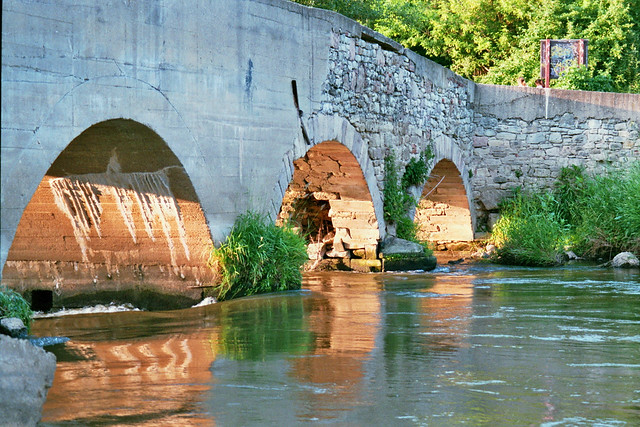
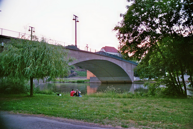
This includes this pavilion-style bridge located east of the community at Moritzburg Castle. Spanning a canal, just 40 meters from its mouth at the White Elster, the bridge appears to date back to the Baroque Period because of the features that are typical for this era. The bridge span itself is a closed spandrel brick arch with a span of 15 meters at the most, long enough to span the canal. The total length appears to be close to 30 meters in length, counting the approach spans. As for the architecture that is on the bridge, it features the following going from center outwards:
For more, click on the symbol below, which will lead you to the Chronicles’ website and with that, more information in detail about this bridge:
Author’s Note: This Mystery Bridge is part of the bridgehunting tour through the small town of Zeitz, located along the River White Elster in the eastern part of the German state of Saxony-Anhalt. A tour guide of the town that has “Rather stood still in time” will follow here in the Chronicles.
All photos were taken by the author in March 2015
Our next mystery bridge takes us back to Germany and specifically, to Saxony-Anhalt. Despite being the most sparsely populated state in the Bundesrepublik based on population versus land size ratio, the state is an attraction as far as nature, historic buildings (many of them sitting abandoned since 1990) and historic bridges are concerned (especially if we look at the bridges in Halle (Saale), Magdeburg and Quedlinburg).
Zeitz is no exception to the rule. Located along the River White Elster between the cities of Gera and Leipzig, and east of Weissenfels and Naumburg, the town of 29,000 was once an industrial community dominated by the rail, steel and agricultural industries. Today, the town is a poster boy of a typical East German community that has stood still in time. Many historic buildings dating back to the late 1800s to 1930s are sitting empty, but have retained its original charm. The city has been used as a platform for films focusing on the GDR. And as far as historic bridges are concerned, it competes with Halle and Quedlinburg in terms of numbers and appearance.
This includes this pavilion-style bridge located east of the community at Moritzburg Castle. Spanning a canal, just 40 meters from its mouth at the White Elster, the bridge appears to date back to the Baroque Period because of the features that are typical for this era. The bridge span itself is a closed spandrel brick arch with a span of 15 meters at the most, long enough to span the canal. The total length appears to be close to 30 meters in length, counting the approach spans. As for the architecture that is on the bridge, it features the following going from center outwards:
Close-up of the dome and cupola
The center of the span features a concrete dome covered with black ceramic paneling. The dome is not completely round for it is four-sided, bordered by a grey ceramic lining. The top of the dome is covered by another, much smaller cupola, resembling a small round barn. The reason for the bridge being considered a pavilion is for it is supported by concrete columns, the rounded ones encircle the dome, while six squared-shaped columns make up the front façade facing the river. Each side is ornamental, representing a different form of inscribed artwork, topped by a finial with sculptures. The middle four feature two inner ones that are taller than the outer two and that line the canal bank. Like the rounded columns, they support the dome and the gabled roof flanking the front end and containing carved artwork. Between the two inner columns are three round columns, supporting the flat head board made of concrete. The outer two of the middle four columns as well as the outermost squared columns also feature three rounded inner columns on each side supporting the head board, resembling the extremely widened version of Brandenburg Gate in Berlin. Photos of the bridge show in detail what the structure looks like in terms of its functionality and aesthetic appearance.
It is unknown when the pavilion bridge was built, let alone who built it. However it is known that the Moritzburg Castle was built in a Baroque style in 1667, replacing an earlier castle destroyed by the Swedish army in 1644 during the 30-Years War. The reconstruction effort took 10 years. Yet the castle dates back to the time of the establishment of the diocese of Zeitz by King Otto I in 968. Both the castle and its neighboring Zeitzer Dom Cathedral were restored in the 1990s and still serves as the key attraction for people visiting the community. The pavilion itself, given its similar appearance to the rebuilt castle, dates back to the 1700s, yet it is unknown when exactly it was built, who was responsible for this unusual construction, and more importantly, why it was built over the canal that was only 100 meters away from its junction with the White Elster.
Any clues as to when it was built? We would love to hear them from you. Submit your information to the Chronicles via e-mail or through its social network pages and any information on the bridge will be added to the tour guide of Zeitz, which will be published in the Chronicles.
Zeitz is one area that has not been explored by any pontists- neither from its own country nor from elsewhere. Yet this bridge represents a vast number of bridges in this area that have a very high aesthetic value and potential for history for other people to know about, especially when it comes to their role in the development of the community and how it survived a wide array of adversities, including surviving two World Wars and 40 years of communist rule that ended in 1989. Like the other bridges in the region where the former East Germany existed, the bridges of Zeitz are definitely worth having a look at, especially if we look at this bridge in particular.
Author’s Note: This is a throwback article written in November 2013. New features in the updated version includes more photos on this page, as well as Google Map, pinpointing the exact location of the bridges profiled here. A link can be found at the end of this tour guide article.
Halle (Saale)- the birthplace of George Friedrich Handel. The second largest city in the German state of Saxony-Anhalt and representing the second half of the metropolis Leipzig-Halle, which has 100,000 of the metro’s 600,000 inhabitants as well as one of the most renowned universities in Germany. Yet when you get off the train in Halle, you may be turned off by the ugly high-rise buildings that date back to the days of the German Democratic Republic, a communist state that existed until the fall of the Berlin Wall in 1989 and German Reunification in 1990. Yet when you walk further towards the City Center, you will see another face of Halle that will sweep you off your feet: architecture dating to the Baroque Period, a statue of Handel overlooking the Cathedral and the Town Square, and further towards the Saale River, there’s the Giebichenstein Castle and the Halle Zoo, one of the largest zoos in the eastern half of Germany (Neuenbundesländer).
Surprisingly, if you are a pontist, you will be surprised to find that Halle has a wide selection of historic bridges that exist along the Saale River, its tributaries and to the south, the White Elster River, which meanders through Leipzig enroute to the Vogtland region in Thuringia and Saxony. There are 131 bridges in and around Halle; 14 of which are declared historically significant and protected by state preservation laws. It is very rare to find historic bridges of at least four different types, or until recently have more than one cantilever truss spans, dating back to the 1880s. And in terms of German history, many of these bridges survived the test of time, including World War II, in contrast to the majority of cities and regions, whose bridges were severely damaged or destroyed through air raids and attempts by the Nazis to fend off advancing Allied troops. This plus the history that is still being sought on these bridges is what makes the bridges of the City of Salt unique.
This article will take you on a tour of the bridges that you should see, when spending a day in Halle. This includes a pair of bridges that no longer exist but are still part of the memories of the Hallenser people that still live there as well as those who were born there but have long since moved away for better possibilities. So without further ado, here is a small guide of the Bridges of Halle, keeping in mind that there are links available that will bring you to the photos and info on the bridge:
This bridge, built in 1733, is the last crossing along the White Elster before it empties into the Saale River in the Hallense suburb of Böllberg. It used to serve a main trading route between Merseberg and Magdeburg before it lost its importance because of the railroads. Today, the stone and concrete arch bridge serves the White Elster bike trail between Halle and Leipzig. Yet the bridge has seen its better days as the arches have deteriorated to a point where reconstruction is badly needed in order to avoid the structure to collapse.
This is the second youngest bridge in the city and the youngest to span the Saale. This bridge spans the Saale’s main river at the entrance to Rabeninsel (Raven’s Island) and features a cable-stayed bridge, whose pylon angles towards Böllberg Weg and the cables support the roadway. The roadway resembles a raindrop as it encircles the pylon. Built in 2000, the bridge measures 85 meters long and is 20 meters tall, easily seen from the main highway a kilometer away.
A few months ago, the Chronicles did a segment on this mystery bridge, spanning the Saale River at the confluence of the Elisabeth Saale and Middle Saale Rivers, west of Böllberg Weg. This bridge was built in 1884 and used to serve a rail line connecting the city with Magdeburg (north) and Merseburg (south) for over 80 years. When the line was abandoned in the 1970s, the lenticular through truss span, measured at 40 meters in length, was rehabilitated and converted into a bike and pedestrian crossing, which still serves its function today. The bridge also has a dark side- and a memorial plaque is placed on the truss as a marker of this tragedy. In the night of 13-14 March, 1919, Karl Meseberg, who was a revolutionary leader during World War I, was murdered on the bridge with his body landing in the Saale. It was found five days later. While the bridge shows its bright side during the day, at dusk, one can feel the presence of a ghost at the bridge, keeping people away from the crossing. This may be in connection with this unfortunate event, but more info in the form of eyewitnesses and evidence is needed to confirm the claims of a ghost at the bridge. If you look to the south of the bridge, you will find a blue tied-arch bridge about 100 meters away. That bridge was built in 2000 and carry water lines connecting the southern and western parts of the city.
This steel through arch bridge is located over the Saale River at William Jost Strasse north of the Hafenbahnbrücke. Built in 1912, the grey-colored span is similar to the Hollernzollern Bridge in Cologne in terms of the design of the bridge, but the portal bracing resemble a bridge located west of Steinbrücke in neighboring Magdeburg. But when passing underneath the bridge, one will see the stone arched approach spans carrying the emblem of Halle on there- an impressive construction by the builder of the bridge, whoever it was.
Spanning the Saale River at the Mansfelder Strasse, there are three crossings located within 60 meters of each other. The oldest span is a polygonal Warren pony truss with riveted connections that used to serve streetcar and vehicular traffic. Yet because of its structural obliqueness- too narrow and too light to support traffic- a vehicular crossing to the north was built in the early 1990s, which was followed by a separate streetcar crossing to the south a decade later. The truss span was later converted to pedestrian use by strenthening the trusses and adding a concrete and brick deck. An economic and interesting way to preserve a piece of history.
Apart from the Hafenbahn, Giebichenstein, and Mühlentor Bridges, the Peissnitz Bridge is one of the crown jewels as far as Halle’s bridges are concerned. Spanning the Saale River at Peissnitz Island, carrying the street carrying the same name, the bridge is one of the most ornamental of bridges, for the 1898 structure features a cantilever Pratt truss design, with ornamental towers supporting street lights, and red quarry stone arch approach spans, presenting its grey and red colors which are typical colors of the city. When built in 1898, the bridge was the only toll bridge in the city, as money was collected for people wanting to cross the bridge and enter Peissnitz Island. This was discontinued in 1921 and the bridge has operated as a free bridge ever since. The bridge is 103 meters long, 70 meters of which represent the main span. Despite sustaining damage during World War II, it was rebuilt in 1946 and was eventually converted to a pedestrian and bike crossing, which remains that way to this day. The Peissnitz Bridge is the only way in and out of the island which houses a vehicle museum complex and the island mini-train. Another bridge spanning the Wild Saale west of the bridge at Weinberg, known as the Elisabeth Bridge, a suspension bridge built in 1913, has been closed to traffic since 2011 and plans are in the making to tear it down and replace it.
This bridge and neighboring Giebichenstein Castle on the lime cliffs of the Saale River go together like bread and butter. The three-span concrete arch bridge is the fourth crossing at this site, being built in 1928 replacing a steel Parker through truss bridge, whose predecessors included a pontoon bridge, ferry and a covered bridge. The bridge is 261 meters long, 60 of which consist of the largest arch span. The bridge features two sculptures on the south side facing neighboring Peissnitz Bridge, resembling cattle- making the bridge a real treat to see. The bridge was renovated in 1995 and again in 2011, but continues to serve vehicular and street car traffic connecting the city center with the western suburb of Krollwitz.
Like the Peissnitz Bridge, the Mühlentor Bridge, spanning Mühlgraben-a tributary of the Saale- at Neuwerk in the northern end of the city, is the most ornamental bridge but in the form of an arch bridge. Art Deco art on the bridge’s railing and four lamp posts can be seen when crossing the 1912 span by car or bike. The railings resemble a Howe truss made of concrete, a rarity one can see these days.
When leaving Halle (Saale) by train heading north, this bridge will be the last landmark to be seen on your way out. Today’s bridge, built in 2005, features a cable-stayed span that is 71 meters tall and 171 meters long, spanning the railroad tracks. Yet the bridge came at the cost of a steel eyebar suspension bridge with pony truss decking, which was built during the first World War, with the help of French soldiers. It was originally named the Hindenburg Bridge before it was changed after World War II. Despite being considered a historic landmark, excessive rust and corrosion, caused by diesel-powered trains passing underneath it, doomed the bridge, causing the city council to decide for a replacement span. The cable-stayed bridge was built to the north of the bridge and after its completion in 2005, the 1916 bridge was dismantled and sold for scrap, despite protests by many who wanted to keep the structure for reuse as a pedestrian bridge.
While some local newspapers have mentioned a bit about Halle’s bridges, more publicity is needed to bring the bridges to light and find out more about their history. While a couple bridges have been documented, others still have mysteries that have yet to be solved. And even more so, perhaps someday when someone writes a book about the bridges in this community, this information will be useful.
A Map with the locations of all the bridges can be found via link here:
Halle (Saale) is famous for many markets and events honoring Handel and other music greats. This includes the Christmas market, which you can click here to read about. Courtesy of sister column The Flensburg Files.
This is a blog about my project of visiting every bridge over the Genesee River and what I learned about the history, structure, and natural surroundings of each bridge.


