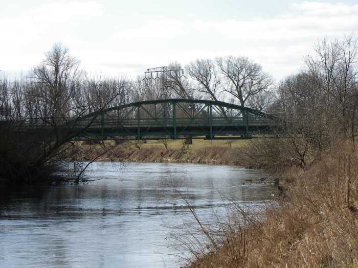
This mystery bridge article takes us back to western Saxony and a village northeast of Glauchau called Waldenburg. With a population of close to 5,000 inhabitants, the town is located on the western bank of the Zwickauer Mulde, has a beautiful castle and historic city center, as well as an international European School. A link to the city’s homepage will show you what the town looks like and some of the things you can do there.
Aside from a 1940s style bridge that is the primary crossing in Waldenburg, the mystery lies behind a canal located between Waldenburg and a neighboring village Remse. There, two bridges- an arch bridge and a steel pony through girder bridge span this canal, which appears to be at least 60 years old, if not, older. The canal was built along the right-hand side of the Mulde, and it is unknown what its use was. One can make one of two conclusions:
The canal was built as a diversion canal, similar to the one built in Glauchau that encircled the western part of the city to alleviate the flooding. There, Heinrich Carl Hedrich had already established himself as the inventor of the city drainage system and may have been involved in the designing and construction of the Flutgraben. He had been the city engineer prior to the flooding of 1858 which caused considerable damage to Glauchau and all places to the northeast, including Waldenburg. It is possible that the canal at Waldenburg dates back to the timespan between 1860 and 1900, the time when Glauchau’s diversion canal was being built. As low as the two crossings were, it would be the most logical conclusion as it passage underneath was (and is still is) next to impossible. Yet having a concrete tiling at the bottom of the canal, plus the proximity of the canal to Waldenburg and the palace could lead to conclusion number…..
The canal provided passage for boats between Remse and Waldenburg. The Mulde is notorious for being shallow but also very muddy, thus making transportation almost impossible. Even water was transported over the river via pipes, thanks to the Röhrensteg in Zwickau, located south of Glauchau and Waldenburg. Therefore diversion canals were the easiest way to go for transporting boats between Glauchau and Waldenburg, having been built in places where the river made boat passage impossible. If this theory is true, then the bridges that exist today were built many years later, between the 1930s and 1950s, when boat traffic ceased because of the coming of the automobile, combined with World War II and its after-effects. However……
The canal may have been used for transporting drinking water between Glauchau and Waldenburg. The evidence behind this lies with the aquifers that exist at the dam where the canal starts in Remse combined with the water treatment station located west of Waldenburg, where highways 180 and 175 meet. As dirty as the river was (and still is to a degree today), the filtering complex was built in 1899 by the city of Meerane (west of Glauchau but owns Remse) where the dirt and other debris were filtered out and the water was cleaned of all harmful bacteria.
To sum up, the canal with the two bridges may have been used as a diversion canal, like the one in Glauchau, for boat passage between Glauchau and Waldenburg or for allowing the flow of drinking water to Waldenburg. The question is which one was used for what. When that is answered, then the question is who was behind both the canal and the two bridges and why?
You have the answers? You know what to do. For reference purposes, check out the Bridges of Glauchau and Zwickau (links highlighted) where you can read more about the Mulde and how it was tamed by crossings that transported water and diversion canals that protected at least Glauchau from further flooding.
Note: This is both a mystery bridge as well as a mystery infrastructure, hence its post in sister column, The Flensburg Files.
During the summer of 1998, I embarked on a bridgehunting tour along six rivers in northern Iowa, among them the Des Moines River. Before splitting into the East and West Forks, the river literally cut the state and its capital Des Moines into two up until Frank Gotch Park south of Humboldt. Then before entering Minnesota, the East branch snakes its way through Humboldt, Kossuth and Emmet Counties, whereas the West Fork stays in Humboldt County, nicking a corner of Pocahontas before halving Emmet County and its county seat Estherville. It was along the West Branch I saw the bridge in the photo above: the Murray Bridge. Located two river miles southeast of Bradgate, this Pratt through truss bridge with pinned connections had a very unique feature on its portal bracing: star-shaped heel bracings welded right through. That, plus the plaque indicating its builder’s date of 1905 all belonged to a local Iowa bridge builder, A.H. Austin. Little did I realize at that time was that although Mr. Austin may have been a local bridge builder, he left a legacy in northern Iowa that is still talked about to this day. And while three bridges were officially credited to his name in a state-wide survey conducted by the late James E. Hippen in the early 1990s, he built more than any of the historians knew about. And henceforth, we will look at his legacy and the bridges that he built up until now, plus the ones that still exist today.
Born Alva Hiram Austin in Colchester, Vermont on 7 September, 1848, he grew to manhood, having graduated at the University of Vermont. After many of his friends decided to heed to the advice of Horace Greeley, the young man of 27 years emigrated west to Webster City in 1875. After having worked for the county auditor and a local church, Alva became interested in bridge building, and in 1877, did an apprenticeship for a bridge builder in Cedar Falls, who was building bridges in Hamilton County, where Webster City is located. Shortly afterwards, he became a contractor, having established his bridge building business in Webster City at 737 Bank Street. For over 40 years, Mr. Austin built dozens of bridges in Hamilton County, as well as surrounding counties, although records have indicated him constructing bridges mainly in Humboldt and Kossuth Counties. It is possible that he built bridges in other counties but more research is needed to confirm these claims. Mr. Austin was known for his athleticism as a civil engineer, having walked 10 miles between his workplace and the bridge building site daily, and thus having known every village and field in the county and its surrounding neighbors.
Mr. Austin was also a committed civic leader, having served as a mayor of Webster City from 1898-1900 as well as the head of the school board from 1899 to 1901, having successfully spearheaded efforts in building the Webster City High School. He later worked as a city inspector, having overseen the construction of the public swimming pool to ensure the design suited the builder’s expectations.
Bancroft Bridge in Kossuth County. Photo taken by Kossuth County Hwy. Dept.
When Alva died on 8 July, 1944 at the age of 96 years, he was survived by his three children, Roy, Jesse and Fred- all of whom had attended college at Iowa State University, yet his daughter Jesse became professor of economics at Cornell University in New York. Especially in his later years before his death, she became his caretaker. Alva’s wife, Chloe Rachel (née: Scullin) died in 1896 after having been married to Alva for 18 years. Another daughter, Grace, had preceded in death 18 years before his ultimate passing.
Riverdale Bridge near Irvington. Photo taken by Kossuth County Hwy. Dept.
As far as bridges are concerned, at least 20+ bridges had been built by Austin in five counties, including Hamilton County, yet Kossuth County seemed to have been his primary customer for at least six bridges were built during his career as a bridge builder. One of them was later relocated to Emmet County. Three were reportedly built in Humboldt County, including the now extant Lewis Street Bridge in Humboldt and the aforementioned Murray Bridge near Bradgate. It is still unknown if and where Austin has built other bridges. However, here is the databank of the bridges that he had built. Information on its dimensions and other photos are available by clicking on the name of the bridge, which will take you to the bridge:
Murray Bridge- This 1905 bridge spans the West Fork Des Moines River southeast of Bradgate, in Humboldt County. The bridge is still open to traffic and considered eligible for the National Register of Historic Places. It’s still open to traffic but plans for possible reuse for bikes and pedestrians are being considered.
Close-up sniper photo of the Armstrong Gravel Pit Bridge. Photo taken in 2011.
Armstrong Gravel Pit Bridge- This bridge spans the East Fork of the Des Moines River north of Armstrong in Emmet County. It can be seen from 160th Street but is privately owned. The bridge was built in 1899 by Austin, but its original location was in Kossuth County. Emmet County’s engineer bought the bridge in 1940 for relocation to the gravel pit, where it served traffic until its closure in the 1970s. The bridge then sat abandoned for three decades until a new owner restored it for private use. The markings on the portals are typical of Austin’s design which could be seen with most of the structures built.
Albright Bridge- Spanning the Boone River at Inkpaduta Avenue south of Webster City, this 1907 bridge represents the common form of the Pratt through truss bridge with A-frame portal bracings and is one of the latest examples of Austin’s work. At 156 feet, this bridge is still one of the longest of its kind in Iowa.
Second Street Bridge- Spanning the Boone River in Webster City, this two-span Pratt through truss bridge with Town lattice portal bracings with curved heel bracings was one of the first bridges built by Austin in 1878-9. It served US Hwy. 20 when it was designated in 1926. Sadly, a truck crashed into the bridge in 1949 and it was subsequentially replaced in 1950.
Blackford Bridge- Spanning the East Fork Des Moines River west of Algona, this bridge was one of the earliest structures built by Austin. It was one of the first with its star-formed heel bracings but one of the last using the Town Lattice portal bracing. The bridge was replaced in 1942 for unknown reasons except that the steel was probably reused for the war efforts.
Albright Bridge south of Webster City.
Lewis Street Bridge- Located in Humboldt, this two-span Pratt through truss with Town Lattice portal and heel bracings used to carry this thoroughfare until the late 1960s, when it was bypassed by the Hwy. 169 bridge to the west. The bridge closed to traffic in 1970, yet attempts were made to convert it to first pedestrian then afterwards a pipeline crossing. Heeding to the demands of the county engineer to have the structure removed with haste, the bridge was removed in 1981. Today, only the center pier and the abutments can be seen.
Riverdale Bridge- Located over the East Fork Des Moines River at 150th Street, south of Algona and west of Hwy. 169, the Riverdale Bridge was a late example of a bridge built by A.H. Austin. He was awarded a contract to build the bridge in October, having completed it in 1900. The 142-foot Pratt through truss bridge with M-frame portal bracings functioned in place until its replacement in 1991.
Bancroft Bridge- Spanning the East Branch Des Moines River west of Bancroft, this Pratt through truss bridge is similar to the bridge at Armstrong in Emmet County. It was built in 1899 yet it was replaced before 1990, when the statewide Iowa historic bridge survey was carried out.
Second Street Bridge in Webster City. Photo courtesy of Hank Zalatel/ IaDOT
(Blue highlighted bridges denotes link to bridgehunter.com website; yellow denotes no info outside this page to date)
According to the surveys carried out by Hippen and Clayton Fraser, several other bridges may have been credited to Austin’s name, yet there has not been any full confirmation. Therefore, there is a plea from you. Do you know of other bridges that Austin built? If so, when was it built, where was it located and most importantly, what did it look like prior to its replacement?
All of these bridges will be added to this page on A.H. Austin in the Chronicles’ Bridge Directory. Stories are also welcomed.
Special thanks to Martin Nass of Webster City for the information on A.H. Austin and Doug Miller at the Kossuth County Highway Department for the photos and information on the bridges in the county.
Author’s note: I had to revise this tour guide as I learned that there were four bridges that needed to be added on there, plus six other bridges that had significant information that warranted editing. Henceforth, I’m presenting you an excerpt on Glauchau’s bridges with a link at the end that will take you to the wordpress website, where you can read everything and see all the photos pertaining to the city’s bridges. Enjoy! 🙂
There is a philosophy pertaining to visiting a town that makes tourism unique and interesting: Always look for the most uncommon and unvisited places first before visiting the main attractions. They have the most valuable information and features that will make you leave town knowing a bit more than before.
Glauchau, located in western Saxony approximately 20 kilometers west of Chemnitz and 13 kilometers north of neighboring Zwickau is a typical farming community. Yet despite having 23,000 residents, the community, which has a historic city center and two castles, is known for its serenity, as there is not much activity directly in the city, but more in the areas full of green, thanks to its parks, the Glauchau Reservoir and the green areas along the Zwickauer Mulde River. Here’s a sample of what a person can see while spending time in this quiet community:
To see more, please click here, and enjoy the photos and facts about the city’s bridges. 🙂
Glienicke Bridge near Berlin, Germany. Photo taken in October 2015
New Photo Apps and other changes to make the online column more attractive.
JENA, GERMANY- Two weeks after introducing the Bridge Builder’s page for the Bridgehunter’s Chronicles’ wordpress page, the column has expanded to include several apps with the purpose to better address the audience. Some of the new features the Chronicles has available for you include the following:
Pin-interest: As part of the plan to replace the flickr photo app, the Pin-interest app will features photos and some information on the bridges the author has visited, linking it back to either this page or the wordpress version. It had been introduced in 2015 but had been seldomly used up until most recently. Having been relaunched, the app will continue its function as before, but will provide the most basic facts for readers to look at. Most of these bridges pinned here will be the ones in the United States and Canada.
Instagram: The Chronicles is the first historic-bridge-related website to have an Instagram app for photos. The purpose is to transfer the photos of the bridges taken by the author directly onto the website. It’s basically following the same method as its colleague in Vermont, Preservation in Pink, but more focused on historic bridges, mostly in Europe and elsewhere, where the author resides (in Germany). Both apps (located under the category Social Network on the left side) will effectively replace the flickr app, for security issues with Yahoo combined with its recent merger have resulted in the author abandoning the app, even though the bridges there will remain on there until further notice.
Google Translate: Readers will now have an opportunity to read about bridges in their own language. The reason behind this is the number of request by readers in Europe to have the texts translated into their own language, including German as many international bridges profiled have originated from Germany. To access the app, scroll down and you will find it on the right hand side.
Planned Events: Open to all pontists, historians and others, planned events can provide readers with information on upcoming events dealing with historic bridges, preservation, and other seminars dealing with history. If you would like your event to be posted, please contact Jason Smith at the Chronicles at flensburg.bridgehunter.av@googlemail.com. Planned events are open for everyone both inside and outside the US.
Tour Guide/Lost Bridges: The Tour Guide page has been updated, including the ones produced by the author as well as the top two finishers of the Ammann Awards for the category Tour Guide as well as winners of the Author’s Choice Awards. The plan is to include more tour guides based on contributions by the author and guest writers, but also based on the results of the Ammann and Author’s Choice Awards from now on. If you have a city or region laden with historic bridges that you wish to write about, please contact the Chronicles.
There are a few touch-ups to be made, including fixing Clustrmaps, adding a couple more apps and updating the themes and other widgets. But the main purpose is to provide better coverage to readers wishing to follow up on the findings of historic bridges and read about the preservation policies that are being advanced. Nonetheless we intend to continue writing and photographing historic bridges, making them attractive for tourists and bringing them up to the attention of people that care about the structures and their significance in terms of history and design and would like to preserve them for generations to come.
Location:White Elster River in the village of Draschwitz, 7 kilometers north of Zeitz in the state of Saxony-Anhalt
Built:1891-2; Damaged during World War II in 1945, Rebuilt in 1946, Restored in 1999/2000
Type:Parker Pony Truss with subdivisions
Length:ca. 30 meters
Status:Open to traffic on a weight limit of 6 tons
During a recent bike tour along the White Elster from Gera to Leipzig (all 90 kilometers of it), I came across this unique structure. After passing through Zeitz and having revisited some of its historic bridges (see link), one would expect to see more of these historic bridges along the river, especially as Saxony-Anhalt has a wide selection of historic bridges worth visiting. One needs to see the towns of Halle (Saale), Magdeburg, Quedlinburg or even the bridges in the Saale-Unstrut River corridor in order to gather the impression that the bridges are being cared for by the state; this includes using funding provided by the European Union but also by the federal government to restore them to their original form while ensuring that cars and bikes can use the bridge.
The Draschwitz Bridge is one of these structures that received this kind of care, as it was restored in 1999/2000, which included new wood decking plus paint on the superstructure, as well as work on the foundations. Given its location on a less used road that is occupied mainly by cyclists and locals driving their cars across, the restoration was worth it, as the bridge serves a local road and the White Elster bike trail, which connects Hof (Bavaria) and Halle (Saale), running parallel to the river until its confluence with the Saale River, between Halle and Leipzig.
But what makes this bridge unique is its unusual truss design. The bridge was built using welded connections instead of pinned connections, as seen on truss bridges in general. Welded truss bridges, together with those with riveted connections were starting to come onto the scene at the time of its construction, as vehicular traffic- namely trains, but also later cars and trucks- had increased since the expansion of the railroad. This prompted the introduction of a network of roads connecting towns on the local level, but later expanded to cities on the regional and in the end national levels. While pinned-connected truss bridges were able to handle light traffic on local roads, as traffic increased and highway systems were introduced, they were replaced with truss bridges with riveted connections. Welded truss bridges were introduced in the 1890s to replace the pinned-connected bridges for despite its biggest asset of dismantling and reassembling the bridge at a different location, missing or broken bolts and cracked eye-bars made it difficult to impossible to relocate the bridge. With welded truss bridges, one has the advantage of relocating the bridge without having to take it apart. Plus with the beams fixed together and welded with bolts, there is more resistance to weight that is on the bridge. The Draschwitz Bridge has this on not only the trusses themselves, but also the outriggers that support the two center panels- an anomaly given the fact that truss bridges usually have outriggers on every vertical beam and panel, especially those in the US built after 1900.
Another unusual feature is the upper chord itself. Normal truss bridges have upper chords that are of either squared shaped beams, V or X-laced or those whose shape resembles the letters I, L and C. They are supported by vertical and diagonal beams that are up to half its size and width. For this bridge, the upper chord and the vertical and diagonal beams are of nearly the same size. However, even more unique is the angled bracings that weave along the top chord, the points sticking outwards by up to 10 centimeters. While some truss bridges in the US and Germany built prior to 1885 may have had features like this bridge, the Draschwitz Bridge is the only known bridge to have an upper chord, decorated with such unusual bracing.
Apart from the renovations, nothing has altered the bridge, even when villagers installed a plaque on the western wingwall, indicating the high water mark set by the flooding in 1954. Chances are, the White Elster may have been rechanneled after that, raising the bridge to prevent it from being swept down stream. Yet, a curved beam connecting that wingwall and the pier raised some eye brows as we don’t know what this serves, except to support the bridge in one way or another.
The Draschwitz Bridge is really a gem in the field when it comes to finding historic bridges. The structure continues to serve local traffic and the Elster bike trail to this day. It’s one of the landmarks one should see when passing through Zeitz and the Elsterau, also the last one to see as one bikes north toward Leipzig, but one that the quiet village of Draschwitz should take pride in, one that Saxony-Anhalt has taken great care of, just like the state’s other historic bridges, and one that historians, pontists, engineers should study further to find out more on its history and structural features. It’s the one bridge that a person can spend lots of hours with the camera and a picnic blanket, sitting and indulging at its beauty, surrounded by a historic and natural landscape.
This slideshow requires JavaScript.
If you know more about this bridge, feel free to post your comment in the Chronicles’ facebook page or contact Jason Smith using the contact information in the About page.
Location:White Elster River in the village of Draschwitz, 7 kilometers north of Zeitz in the state of Saxony-Anhalt
Built:1891-2; Damaged during World War II in 1945, Rebuilt in 1946, Restored in 1999/2000
Type: Parker Pony Truss with subdivisions
Length:ca. 30 meters
Status:Open to traffic on a weight limit of 6 tons
During a recent bike tour along the White Elster from Gera to Leipzig (all 90 kilometers of it), I came across this unique structure. After passing through Zeitz and having revisited some of its historic bridges (see link), one would expect to see more of these historic bridges along the river, especially as Saxony-Anhalt has a wide selection of historic bridges worth visiting. One needs to see the towns of Halle (Saale), Magdeburg, Quedlinburg or even the bridges in the Saale-Unstrut River corridor in order to gather the impression that the bridges are being cared for by the state; this includes using funding provided by the European Union but also by the federal government to restore them to their original form while ensuring that cars and bikes can use the bridge.
The Draschwitz Bridge is one of these structures that received this kind of care, as it was restored in 1999/2000, which included new wood decking plus paint on the superstructure, as well as work on the foundations. Given its location on a less used road that is occupied mainly by cyclists and locals driving their cars across, the restoration was worth it, as the bridge serves a local road and the White Elster bike trail, which connects Hof (Bavaria) and Halle (Saale), running parallel to the river until its confluence with the Saale River, between Halle and Leipzig.
But what makes this bridge unique is its unusual truss design. The bridge was built using welded connections instead of pinned connections, as seen on truss bridges in general. Welded truss bridges, together with those with riveted connections were starting to come onto the scene at the time of its construction, as vehicular traffic- namely trains, but also later cars and trucks- had increased since the expansion of the railroad. This prompted the introduction of a network of roads connecting towns on the local level, but later expanded to cities on the regional and in the end national levels. While pinned-connected truss bridges were able to handle light traffic on local roads, as traffic increased and highway systems were introduced, they were replaced with truss bridges with riveted connections. Welded truss bridges were introduced in the 1890s to replace the pinned-connected bridges for despite its biggest asset of dismantling and reassembling the bridge at a different location, missing or broken bolts and cracked eye-bars made it difficult to impossible to relocate the bridge. With welded truss bridges, one has the advantage of relocating the bridge without having to take it apart. Plus with the beams fixed together and welded with bolts, there is more resistance to weight that is on the bridge. The Draschwitz Bridge has this on not only the trusses themselves, but also the outriggers that support the two center panels- an anomaly given the fact that truss bridges usually have outriggers on every vertical beam and panel, especially those in the US built after 1900.
Another unusual feature is the upper chord itself. Normal truss bridges have upper chords that are of either squared shaped beams, V or X-laced or those whose shape resembles the letters I, L and C. They are supported by vertical and diagonal beams that are up to half its size and width. For this bridge, the upper chord and the vertical and diagonal beams are of nearly the same size. However, even more unique is the angled bracings that weave along the top chord, the points sticking outwards by up to 10 centimeters. While some truss bridges in the US and Germany built prior to 1885 may have had features like this bridge, the Draschwitz Bridge is the only known bridge to have an upper chord, decorated with such unusual bracing.
Apart from the renovations, nothing has altered the bridge, even when villagers installed a plaque on the western wingwall, indicating the high water mark set by the flooding in 1954. Chances are, the White Elster may have been rechanneled after that, raising the bridge to prevent it from being swept down stream. Yet, a curved beam connecting that wingwall and the pier raised some eye brows as we don’t know what this serves, except to support the bridge in one way or another.
The Draschwitz Bridge is really a gem in the field when it comes to finding historic bridges. The structure continues to serve local traffic and the Elster bike trail to this day. It’s one of the landmarks one should see when passing through Zeitz and the Elsterau, also the last one to see as one bikes north toward Leipzig, but one that the quiet village of Draschwitz should take pride in, one that Saxony-Anhalt has taken great care of, just like the state’s other historic bridges, and one that historians, pontists, engineers should study further to find out more on its history and structural features. It’s the one bridge that a person can spend lots of hours with the camera and a picnic blanket, sitting and indulging at its beauty, surrounded by a historic and natural landscape.
If you know more about this bridge, feel free to post your comment in the Chronicles’ facebook page or contact Jason Smith using the contact information in the About page.
Boyd Bridge at Greensburg City Park in Craig, Indiana- a fine product of CSBC. Photo taken by Tony Dillon
This article is in connection with the creation of the database for the Bridge Builder’s Directory in the Bridgehunter’s Chronicles’ wordpress page, which you can click here to view.
Indiana, together with Minnesota, Ohio, Illinois, Pennsylvania and New York, were considered the big six in terms of steel construction and bridge building during the heyday of architectural and infrastructural expansion between 1880 and 1920. Steel mills were found between Minneapolis and Pittsburgh, including the metropolises of Chicago, Indianapolis, Canton and Cleveland. Several schools of bridge building existed, which churned out the finest bridge builders and businessmen in the field. This included the Indiana school, which had over a dozen bridge builders, including the longest known bridge builder in the state, The Central States Bridge Company (CSBC). But what do we know about the company and its founder to date?
The company was created in 1895 as the New Castle Steel Sewer Pipe Company by Eugene Runyan and others, with its headquarters in New Castle, IN. It later expanded its services and began building bridges. In 1897, in response to the changing trends in infrastructural work that included the increasing demand for metal truss bridges, the company changed its name to New Castle Bridge Company and would later receive contracts for bridge building in Iowa, Virginia, and Michigan. In 1905, the company relocated to Indianapolis and was renamed the Central States Bridge Company. Prior to World War I, the bridge company constructed dozens of bridges of its kind in 10 states, including: Indiana, Minnesota, Oklahoma, Montana, Wisconsin, Illinois, Ohio, Michigan, Nebraska and New York.
Lilleberg Bridge in Jackson County, MN (1910-1976) Source: Jackson Co. Hwy. Dept.
Many of these bridges have been either documented by the State Historical Societies, HABS/HAER or both and are either listed on the National Register of Historic Places or are considered eligible. Yet many of these CSBC bridges are disappearing fast as they have been either replaced or demolished in the past 20 years. This includes the following bridges:
Lefarge Bridge in Wisconsin: This bridge used to be the Hudson Toll Bridge until it was relocated in 1953 to its final destination. It was documented by HABS/HAER before it was removed in 1983.
Standing Rock Bridge in Montana: This three-span polygonal Warren through truss bridge was one of the key historic sites along the Yellowstone River until its replacement in 1991
Little Flatrock Bridge in Indiana: Decatur County was CSBC’s primary customer as a half dozen of its bridges were built there between 1900 and 1916. This one had a fancy portal bracing, yet efforts to save the bridge from the wrecking ball failed, as the bridge was removed in 2000 after its replacement was built. However, the Applegate Bridge has a similar feature and is in storage, awaiting relocation for reuse.
Lilleberg Bridge in Minnesota: The Lilleberg Bridge was one of the younger bridges built by Central States, for it was constructed in 1911. It was the fourth structure at the location and used to be a centerpiece for the now extant village of Belmont. Sadly, flood damage in 1969 resulted in its replacement in 1976 on a new alignment. One can still see the lally columns from the current structure today.
Structures that are still standing include:
Boyd Bridge in Indiana: This used to span Sand Creek at CR 700 before it was relocated to Greensburg Park in Craig in 2006, nicely restored and now part of a bike path.
Locust Street Bridge in New York: Located in the town of Waterloo, this 1914 arch structure was the only known bridge of its kind built by CSBC and is still in service today.
Little is known what happened to the Central States except to say that even though the founder, Mr. Runyan, died in 1913, the business continued building bridges well into the 1970s and 80s, according to the Indiana Historical Society during the author’s correspondance in 2007. Whether the company still exists today, either as an independent entity or as part of a larger steel and/or bridge company remains unknown to date, nor do we have much information on the later structures built by CSBC.
If you know more about the company, especially regarding Euguene Runyan’s life and the company’s existence sice 1919 in terms of bridge examples, advertising or other information, please contact Jason Smith at the Chronicles, under the following address: flensburg.bridgehunter.av@googlemail.com. Further information will be added to this page pending on the information that is received at that time.
In the meantime, check out the list of bridges built by CSBC by clicking on the following links below:
Petersburg Village Bridge in Petersburg (Jackson County), MN Photo taken by MnDOT in 1963
This article is in connection with the creation of the database for the Bridge Builder’s Directory in the Bridgehunter’s Chronicles’ wordpress page, which you can click here to view. More information is needed on this gentleman, who contributed a great deal in engineering southwestern Minnesota, including Jackson, Cottonwood and Murray Counties. If you have information that will help, the contact details are at the end of the article.
Charles Wallace Gove is a little known figure in the engineering business as his primary focus was building bridges, roads and ditches in southern Minnesota, in and around Cottonwood County (where Windom is located). Little is known about the bridges he built except records indicated he built two bridges in Jackson County (which are profiled at the end of this info sheet) and an unknown number in his county. On the political level, he was a dedicated farmer and political journalist who left his mark at the State Capitol with his plan that is still being used today for commercial farming.
Born in 1863 in De Witt, Iowa, he and his brother Wade settled in Jackson County, Minnesota in 1886, where he farmed and taught in nearby Lakefield until his move to Cottonwood County in 1895, where he established his farmstead in Great Bend Twp. northwest of Windom. From that time on until his death in 1936, Mr. Gove busied himself with the transportation sector, first as a surveyor until 1912 and then afterwards, as a county engineer. During his tenure as surveyor, he led the efforts in constructing ditches in Cottonwood, Nobles and Murray Counties and later on in parts of Jackson County, as flooding was rampant during that time, and farmers needed them to provide runoff for the excess waterflow.
It was also during that time that he led the bridge building effort in parts of Jackson County, as county officials were turning to local builders who were willing to construct bridges at an affordable price. While the bridges he built were not spectacular in design, his most worthy structures were the bridge near Rost as well as the second crossing at Petersburg, built in 1912 and 1915, respectively. When he was not building bridges and maintaining the roads in Cottonwood County, he wrote various articles and essays for local and regional newspapers, including his most famous one, the Minnesota Plan. There, he advocated simpler farming techniques, which included constructing deeper and systematic plowing before planting and ditches to provide water run-off. His writings dealt with philosophical thoughts mixed with a bit of wit and humor that made the readers enjoy every paragraph. He was recognized by the state for his work at the time of his death. Charles Gove died on 29 August, 1936.
Rost Bridge. Photo take by MnDOT in 1948
The Bridges built by C.W. Gove:
Rost Bridge
Location: Little Sioux River at 390th Avenue, 0.1 mile south of Interstate 90 in Rost Twp.
Type: Steel stringer with steel railings (altered in the 1970s)
Dimensions: 32.3 feet long; 16.4 feet wide
Built in 1912, replaced in 2002
This bridge used to carry a key road to the unincorporated village of Rost, located 2 miles north of the bridge. The village had a couple trading businesses and a church, the latter of which still exists today. The contract was given to C.W. Gove to build this bridge on 8 July, 1912, which was completed by the end of that year. The road was cut off by the Interstate in 1973 and after 90 years in service, this bridge was replaced by a pair of culverts in 2002.
Petersburg Village Bridge
Location: West Fork Des Moines River on a local road in Petersburg
Type: Two-span Pratt pony truss with pinned connections and steel cylindrical piers
Built in 1915 replacing an earlier structure; destroyed in the 1965 flooding during the construction of its replacement upstream. Replacement bridge opened in 1965
The Village Bridge was the longest bridge known to have been built by C.W. Gove. He was awarded a contract to build the structure for $3050 to replace the bridge built 30 years earlier, just after it was founded. The bridge was in service until the Flood of 1965, which destroyed the structure. It was also at that time that a construction worker at the new bridge, located one mile west of the old one, fell into the icy river and drowned. His body was recovered in June 1965, three months after the replacement bridge opened to traffic
Do you know of other bridges built by C.W. Gove or have some more knowledge about the Minnesota plan or his written work? Let’s hear about it. Contact Jason D. Smith at the Chronicles at flensburg.bridgehunter.av@googlemail.com and feel free to provide some additional information for this fact sheet about this unknown engineer who left a mark on the local level. The info will be added and/or modified based on what comes in.
Photos of the Rost and Petersburg Village Bridges are courtesy of MnDOT
Some additions and expansions of the Chronicles is getting in full gear as we’re receiving a wider selection of the audience. This includes new social network pages and a couple pages on the wordpress menu. This is one of them.
In 1984, Victor Darnell created a directory with a list of American bridge builders and the dates of their existence, based on the data found through research by historians on the local, state and national levels. It was later expanded by James Stewart, who provided not only detail about the builders listed, but also included the names of other smaller bridge builders that may not have contributed much on a regional level, but did do on a local level. A link to the guide can be found via link here.
Yet, thirty-plus years later, we still have more bridge builders that were not listed in the Darnell category, and we still have a lot of questions about the ones listed. Examples include the Continnental Bridge Company and its gap during the bridge building era, the question about the number of bridges built by Raymond and Campbell in Minnesota and Iowa, and even the question of more involvement of bridge builders in the Minnneapolis, Pittsburgh or even Chicago schools, as documented by prominent bridge historians, like Stewart, Fred Quivik, Eric Delony and others. From the author’s perspective, the key questions we need to know about are the following:
Who founded the company and what was his/her profession prior to that?
How long did the company existed? Did it expand or fold under the pressure of competition?
What characteristic features of the bridge company can be found on the structures in terms of design, portal, plaques, keystones, etc.?
Which bridges were built by the company and where are/were they located?
What about the role of bridge builders in other countries? Did they bring their expertise to the United States, like Ralph Mojeski did, or did they remain competitive on their native soil?
While extensive research has been done with the main companies, like King Bridge Company, American Bridge Company, and the Champion Bridge Company, more is needed for the other companies, whose history is full of holes, resembling Swiss cheese. For those wishing to find out more about the bridge company for their research, a library with a detailed list of bridge builders is the starting point.
Henceforth, the Bridgehunter’s Chronicles has just created a directory of Bridge Builders which can be found on its wordpress page (click here for details). Here, you can find information that has been written about them, categorized in alphabetical order and classified in brackets where they originated. Also included are the dates of their existence. The essays and other facts come not only from the Chronicles itself but also from different websites. All you need to do is click on the bridge builder you are seeking, and the information is right at your finger tips; included are examples of bridges built by the company, even though there were perhaps more than what is presented.
Apart from additional bridge builders that will be provided by the Chronicles, both based on previous research on the US ones as well as those currently being researched in Europe, the Chronicles is also taking articles and essays of bridge companies, engineers and the like that have not been listed yet. If you have a bridge company that you researched and would like to have posted on the Chronicles page, please contact Jason D. Smith at the Chronicles, using the contact details below. Please include examples of bridges built as well as either a couple photos, links to the bridges or both if you have some that are related to the company. They will then be added to the directory.
The list provided at the moment is not complete, but more bridge builders will be added as the weeks go by. Only you can make the library bigger. So if you have a bridge company worth adding, we’re looking forward to reading about it. After all, another researcher, historian, teacher or even enthusiast will be thankful that you contributed on the research.
State Highway 78 Bridge at the Texas-Oklahoma border
MADISON (WI)/ MINNEAPOLIS (MN)/ AUSTIN (TX)/ PORTLAND (ORE)- Historic bridges represent a significant portion of the history of American architecture and infrastructure. Its unique design, combined with the significance in connection with the bridge builder and/or other key events makes them valuable pieces of our landscape- encouraging people to visit, photograph and even learn about them. Yet when it comes to preserving them, many people don’t know the policies that exist, such as the Historic Preservation Laws (and in particular, Section 106), many ways to rehabilitate and repurpose them and avoiding adverse effects when they need to be remodeled to meet the demands of today’s traffic standards.
The National Preservation Institute, in collaboration with Mead & Hunt, and Departments of Transportation in Minnesota, Texas and Oregon are conducting two seminars this year to focus on ways of designating and preserving what is left of our engineering heritage. Amy Squitieri (Mead & Hunt), Kristen Zschlomer (MnDOT), Amber Blanchard (MnDOT), and Steve Olson (Olson & Nesvold Engineers) are heading two interactive seminars, scheduled to take place on the following dates:
April 4-5, 2017 in Austin, Texas
September 12-13 in Portland, Oregon
In the seminars, one will have a chance to look at bridge history and typology, rehabilitation and preservation techniques used on historic bridges that meet current and historical standards, ways to avoid adverse effects when reconstructing bridges, finding alternatives and solutions to bridges slated for replacement, and navigating through the process of Sections 106 and 4(f) of the Historic Preservation Laws.
Those who have taken the seminar have benefitted from this in a substantial way, as you can see in the evaluation comments in the NPI page (here). Participants of the interactive seminar include federal and state agencies dealing with transportation and historic properties, as well as managers and consultants preparing compliance documents under actions dealing with Section 106 and other laws, as well as those interested in learning about the policies and practices involving historic bridges.
Minnesota, Texas and Oregon are three of only a dozen states in the country that have a comprehensive and successful track record in statewide inventories and the preservation and management of historic bridges. Some examples of successful bridge stories in photos can be seen below.
Piano Bridge in Texas- This bridge was restored in 2013- when the truss bridge was dismantled, sandblasted and reassembled; known as in-kind restorationBroadway Avenue Bridge in St. Peter, MN: Restored in 2016Portland Water Works Bridge in Oregon, prior to its relocation to a storage area in 2015, awaiting reuse. Photo taken by Michael Goff
Costs and discounts are available via link. You will receive a confirmation of the reservation as well as the venue and schedule of the events. For more information, please contact NPI via phone at (703) 765-0100 or send them an e-mail at: info@npi.org.
This is a blog about my project of visiting every bridge over the Genesee River and what I learned about the history, structure, and natural surroundings of each bridge.