Co-produced in connection with Germany’s Reunification of 1990, which is October 3.
When we think of Germany and its historic bridges, one of the first structures that come to mind is the Hohernzollern Bridge. Spanning the River Rhine, the three-span steel through arch bridge serves rail traffic and is located approximately 500 meters from the central station of Cologne. Another 200 meters away and one will find him/herself at the world-famous Cologne Cathedral (D: Kölner Dom). The bridge is a popular place for love locks, which can be found along the railings on pedestrian portion of the bridge. For photographers, the bridge makes for perfect photos, especially if it is together with the Cathedral, like this one:
While I was in Cologne in February 2010, I took a couple hours to photograph the bridge, even though a major storm with powerful winds swept through Germany forcing the shutdown of train services. I eventually had to stay overnight in Frankfurt (Main) after having been stranded for hours along the ICE-Train line going home to Thuringia. The two-hour delay in Cologne was in connection with a connecting train to Frankfurt having been cancelled. Despite the wind and rain, I took the chance and got a few photos of the bridge at angles that were suitable for shots.
While I was photographing the bridge I also got some with the statues located at the portals, like this one taken from Cologne Station:
It took four years to construct the bridge, which opened in 1911. Rudolph Schmidt oversaw the planning and design of the 409 meter long structure which has six tracks and a bike/pedestrian path. Fritz Beerman and Friedrich Dircksen oversaw the construction of the bridge with MAN in Gustavsburg providing the steel and the workers. The construction featured not only the steel arch spans and the stone arch approaches, but the statues of the German emperors at each corner of the bridge and this:
This was the postcard of the portal of the Hohenzollern bridge featuring one of the most, well-built portal entrances of the railroad bridges built in Germany, prior to World War II. There were three entrances for rail traffic, two watch towers and a skyway between the towers, per portal entrance! As you can see in the picture, the bridge was a crossing for all to use, for not only the trains used it, but also the trams, horse and buggy and of course, the pedestrians.
The bridge was destroyed on March 6, 1945 by the Nazi Army as they fled the American troops who had already occupied the city center of Cologne. Because of its historic value, sections of the arch spans were saved and those that were destroyed were rebuilt to mimic the original bridge. This was completed in 1958 but unfortunately, it came at the cost of the towers and the portal entrance- they were torn down completely! An additional arch span was added in 1989, thus its present-day appearance. The statues of the emperors and the stone arch approach spans were left in place and restored to its original form.
The bridge today is a popular attraction as thousands of visitors cross the bridge on foot daily, enjoying the scenery, tying the knot through love locks and getting some great photos of the bridge. The bridge serves both long-distance and regional train services with hundreds of trains using the bridge every day. It is a unique structure with a high degree of historic value, putting it in the top three places to visit while in the largest city in western Germany. If you are stranded for a couple hours due to train delays or cancellations, take the time to visit the bridge and the adjacent Cathedral. The two hours will be well worth the visit.
Speaking from experience, the two hours was worth it. Even if the storm was nearby. 😉
.
More information on the Hohenzollern Bridge can be found here:
Bridgehunting and Archeology have one common trait, and that trait has to do with discovering an unknown bridge, one whose history requires some in-depth research, interviews and even some digging for any artefacts. In the end, the search for the facts are ones that are interesting and worth writing in the history books. It has to do with being curious and seeking information, even if it means doing some excavation work. 🙂
In the past two weeks in two separate podcasts, I had mentioned two discoveries of bridges that were built during the Roman Empire: There’s one near Duppach in the Eifel region of western Germany on the former road connecting Cologne and Trier, which could be older than the oldest crossing in existence in Germany. And then there is this one: a Roman crossing near Chepstow that crossed the Wye and used to connect England and Wales at their natural border before it was redrawn in modern times. This one was interesting because Romans were known for their advanced architecture and infrastructure which transported people and goods across long distances. It included the construction of bridges and aqueducts that crossed large rivers and valleys, some of which still exist today and have become tourist attractions.
I had an opportunity to interview Simon Maddison of the Chepstow Archeological Society about this discovery of the bridge. He’s the field leader of the team that has been excavating artefacts in and around Chepstow Castle and his team discovered this ancient bridge relic in the water. There were a lot of challenges in getting the parts out but there were some things that we can learn about this bridge- not just when it was built, but also the how and whys. Here is the dialog I had with him, hope you enjoy it, and feel free to comment in the section below.
************
1. How long have you been an archeologist in general? What areas have you and your team(s) explored?
I am a retired engineer and started my transition to Archaeology in 2006 with study and field work. I finished my Masters at the Institute of Archaeology, UCL in 2016 focused on the distribution of Hillforts in Britain and Ireland. I was appointed an honorary research fellow at UCL in 2021, where I continue research work on hillforts. I have worked on excavations on a neolithic settlement site in Orkney from 2007-2013, two iron age hillforts, one at Bodfari in North Wales and currently at Nesscliffe in Shropshire. I lead field work for the Chepstow Archaeological Society. We have been working on an 18th Century building complex nearby since 2021 which may have medieval origins. We are now focused on the putative Roman crossing and its landscape context.
2. How long have you been doing archeological work at and around Chepstow Castle? And prior to discovering the bridge relicts, what artefacts have you and your team found so far?
As mentioned above, since 2021. We have uncovered an 18th Century cottage, a probable agricultural building, and an enigmatic tower base that might be a medieval mill. These are in woodland/ parkland a little to the north of Chepstow and associated with the grand house that was there. It is now a ruin.
.
3. Tell us a bit about the castle and its history.
– that is a big one. Chepstow is on the Wye, close to the river Severn. The Wye forms the border to the southern part of Wales. It is a strategic location for accessing South Wales. The castle was started in 1068 shortly after the Norman conquest and is probably the oldest stone castle in Britain. Chepstow is on the border of the Welsh Marches, and the Marcher Lords were given a lot of autonomy by William to try and subjugate the Welsh. The original keep was extended with curtain walls and additional fortifications over the following 2-300 years and was also the site of a short siege during the Civil War. It was not slighted after this but repaired. This says something about its importance as a military location.
.
4. How did your team come to finding the bridge relic?
We have been researching this for a number of years. There is a long supposition that there was a Roman crossing on or near this site, from antiquarian reports of timbers in the riverbed and finds of traces of Roman roads on either side of the crossing. These are recorded on the earliest OS maps, from around 1885. The timber structure we uncovered was excavated in 1911 (see below) and there are plenty of newspaper reports and some photographs in the local museum. There is also a plan of its location, which is not geolocated, and a very detailed drawing of the structure. Careful research work using the plan and modern GIS tools enabled us to identify the probable location of this bridge pier. In 2003 a TV programme was made about a timber structure on the other side of the river, which was located at extreme low tide, and timber samples were taken. Unfortunately, this was never written up, and we have not been able to locate any records. These included excavation of the Roman agger leading to the crossing, a geophysics survey and a topographical survey. Timber samples were taken, but the dendrochronological analysis was inconclusive. We did however manage to track down the C14 report, which gave a date range of late first century to early second century AD. This puts it firmly in the early period of Roman occupation, although does not give us a more precise date.
.
5. When did you find the bridge relic?
We conducted a survey in May, which identified the feature investigated in 2003, and we were able to geolocate this and make some basic records. We also identified timbers on the other side of the river where we predicted from the 1911 records. We returned on 4th August to conduct excavation when there was an extreme low tide event.
.
6. You mentioned during an interview that you had to remove portions of the bridge relic during low tide. Tell us more about it and how it was done.
The site was only exposed for just over 2 hours so it was extremely intense. Chepstow has one of the largest tidal ranges in the world. At its peak that is around 14m (44 feet). We drained the tidal pool first, by moving rocks and then worked around two or three of the upright timber stumps. We were able to quickly identify several horizontal beams and tenon/mortice joints. We exposed about one third of the upper part of the feature. The mud was extremely difficult to work in, and we needed the help of the local rescue association to get us to the site and move us around. Without their help it would have been extremely difficult and seriously dangerous. We had a dendro expert with us who selected particular timbers to sample and cut three slices out of different timbers with an electric chainsaw. These will be used for dendro analysis and C14 analysis. We want to confirm that the timbers are similar in date to those on the other side of the river. Although the scale of the timbers and the nature of construction suggest that it is Roman, we cannot assume this, and scientific dating will hopefully corroborate this assumption.
.
7. You mentioned that the bridge was over 2000 years old. Why is that?
– Actually, it would be around 1900 years old. It would be consistent with the C14 date obtained for the other side of the river, and the occupation of South Wales by the Romans. See below.
.
8. According to history, Britain and Wales became part of the Roman Empire in 43 AD after several attempts under Julius Caesar and later Augustus. The two remained under Roman rule until 410 AD, less than a century before the downfall of the western half of the Roman Empire. In your opinion, when do you think this bridge was built and why?
Try this for a start: https://en.wikipedia.org/wiki/Roman_conquest_of_Britain . Caesar made two expeditions to Southern Britain in the first century BC, but there was no conquest per se. Britain traded with the Roman empire and there were lots of engagement, but it was not part of the empire. Perhaps some of the southern tribes became ‘client kingdoms’. Augustus planned military campaigns to Brittain, but they never happened. It was in 43AD that Claudius invaded Britain and started its incorporation into the empire. It was a protracted process, and Scotland was never conquered despite more than one attempt. The conquest of Wales took some time, and there was resistance in South Wales by the local Silures people for over 20 years. The legionary fortress at Caerleon was established in 75 AD, and the tribal centre Venta Silurum at Caerwent, just a few miles west of Chepstow in the same year, once the Silures were subjugated.
.
9. Roman bridges were primarily either stone arches or wooden beam bridges. Judging by what you found at the bridge ruins, what kind of bridge do you think was built?
– The foundations we have discovered are timber with the remnants of timber uprights coming out of the cutwater structure. There is no evidence of any stone structure. There never has been a stone bridge across the Wye around Chepstow, not in medieval times nor later. What we have identified creates many questions. We appear to have two bridge piers which are each approximately 40m from the riverbank and 40m from each other. This is way too long for bridge spans, so if they are the remnants of a bridge then there must have been more bridge piers. That it was timber may be due to the tidal range and the challenge of building anything so high and subject to so much tidal flow in each direction. Also, the approach from the Welsh bank is not obvious, although that on the English side could have been straightforward. It is conceivable that there never was a bridge but that they were supports for floating pontoons and a ferry, so the question is wide open.
.
10. Apart from providing a connection between England and Wales, why was that bridge built? For what purpose was the bridge needed?
There are traces of Roman roads coming down from Gloucester towards Chepstow, and onwards from Chepstow to Caerwent, although the path through Chepstow is very uncertain. It seems highly likely that there was a crossing of some sort at this point in Roman times, based on this evidence. It may have been short-lived or it may have existed past the Roman times, we really don’t know. There certainly has been a bridge on or near the current bridge location in Chepstow since medieval times but there are no records of when it might first have been constructed. It would have provided the most direct route along level terrain close to the river Severn. It is possible that earlier routes were higher up, inland, with a crossing at e.g. Monmouth, where it is no longer tidal, and this may have been the earliest military route into south Wales, but this is conjecture. It is possible that the roads and crossings around Chepstow were to do with the military invasion or later after subjugation of the territory. If we can get dating with the precision of dendrochronology then this may help address some of these questions.
.
11. Why was Chepstow such an important area during the Roman times and also afterwards?
Chepstow sits close to the mouth of the Wye. It has been an important trading location for goods coming down the Wye, from the hinterland, probably from prehistory and up until the 19th Century. In early times this would have included timber products for construction, shipbuilding and tanning, and in later times metals and wire from the proto-industrial metal working sites along the Wye at Tintern, for example. There are a number of hillforts close to the Wye not far from Chepstow which may have been to do with control of trade up and down the river, indicating its importance in prehistory. It is the lowest crossing point on the Wye and to this day still carries road traffic from Gloucester into South Wales. Its military importance is illustrated by the building of a very strong castle there shortly after the Norman invasion.
.
12. An earlier explorer in 1911 discovered the bridge relics at the same spot your team discovered it. Explain more about it and why parts of it were removed.
This is a complex story, and I will summarise briefly. In 1911 an American, Orville Owen, came to Chepstow in the search for evidence that Francis Bacon wrote the works of Shakespeare. His efforts at decoding the texts suggested to him that there was a chest of lead buried in the banks of the Wye. He conducted a campaign of work that excavated pits in the intertidal zone of the river. We don’t know, but suspect he thought that the timber pier may have been to do with this. He certainly excavated it comprehensively, along with a number of other pits in the riverbank nearby. Some of the coffer dams are still visible. We have newspaper reports of the time, and a few photographs in the museum, as well as the plans mentioned above. We wanted to be sure that we had found what he uncovered, and that the timbers were not part of his excavation rigs. From what we found, it seems that part of the structure is no longer in situ, but it seems more likely that it has simply been damaged by flood events over the past 100 or so years, as it seems he did not back fill the excavation. His work was unsuccessful and nearly bankrupted him. Others followed in his footsteps in the 1920’s but sought other land based locations. Unfortunately, none of them left any records that we have found. Of course, none of them were looking for the Roman crossing …
.
13. What are the next steps in the archeological research on this bridge relic?
We may return to record in detail the timbers and in particular the carpentry joints. Note that any attempt to reach the site requires considerable resource and planning, and time on site is extremely limited. Most importantly is the ongoing scientific dating analysis on the timber samples. Apart from this we are studying the landscape on either side of the river to understand how the road may have approached this crossing. We will also consider where any other bridge remains might be located in the intertidal zone, although the practicalities of trying to locate these may be insurmountable.
.
14. Could you imagine building this bridge, mimicking the one from over 2000 years ago?
This is a tough one. We are researching Roman timber bridges and how they might have been constructed, in particular what the individual span lengths may have been. There is not a lot of evidence for Roman timber bridges, but plenty for stone ones. The remains on the English side are the tops of heavy timbers that have been piled into the river bed. That represents a significant piece of civil construction in its own right. Just to bring the timbers we have found on the Welsh side to the site would be some achievement, the structure is a lozenge of about 13m end to end and 6m across. The individual timbers are perhaps 10-12 inches square. They would have required barges, piling rigs and lots and lots of manpower, including finding, felling, transporting the timbers to a convenient location, and the floating them to site. Working in those tidal conditions would be a challenge today with modern equipment. Having said that it is amazing what can be done with large amounts of manpower, such as the Roman army had at its disposal.
.
15. What is your favorite bridge in general? What bridge in the UK would you recommend a tourist seeing while visiting?
It’s a hard one. Probably the tubular suspension bridge at Saltash in Devon, constructed by Isambard Kingdom Brunel. It has his name on it. ‘IK Brunel, Engineer’. A totally original design. What a legacy! It still carries rail traffic today. The old road bridge in Chepstow is a very early iron bridge and is a very attractive site to visit.
.
Thank you Simon for your help and also for the photos. Wishing you the best of luck and hope you can find out more about what you and your team have discovered. The BHC will keep you posted as well. And remember: Your bridge matters. ❤
We are pushing up the Post Card Friday to Thursday to allow for some space for the last segment of the Interview series with the winners of the 2022 Bridgehunter Awards.
Our fourth Post Card Friday series is the same as the 199th Mystery Bridge. It takes us to Bad Brambach in the southwestern part of Saxony towards the Czech border, located 20 kilometers east of Asch. This bridge is one of the most unique of covered bridges in the area. It spans a ravine near a spa resort and park. The bridge is built made of wood, but we don’t know how many times it has been built and rebuilt. A pair of post cards shows the bridge in two different time periods. In one time period (see below), the bridge was built using wooden beams. In one time period (above) it was built using Warren trusses with outriggers. The assumption is that the one above is younger than the one below.
In both cases, there is a covered bridge, whose trusses is a cross between a Howe and a Town Lattice. One may compare this with a Bailey, yet that truss was patented during World War II and made using steel. The portals feature peacock style bracings. One has to assume that the bottom picture dates to the late 1800s to early 1900s whereas the top picture came from the first part of the 1900s; the covered bridge span having been built in the era towards the turn of the Century. But these are all assumptions and more research would be needed to find out when was the this bridge built. Specifically:
When was the first bridge built, counting the covered bridge span?
How many times was the bridge rebuilt?
When was the modern bridge built?
Who was behind the design and construction of the covered bridge, counting the rebuild?
The modern variant appears to have been built 10 years ago. A link to the photos of the new structure can be found here.
Any ideas? Feel free to comment below or in the Chronicles’ social media pages.
As announced a few weeks ago, this month, the Month of June, we will be featuring interviews with the winners of the 2022 Bridgehunter Awards, providing you with some insight on the projects involving historic bridges that won them international recognition and accolades for their fine work. It is hoped that the interviews will give some of you an incentive with your projects, whatever that may be.
We will start with our winner of the 2022 Bridgehunter Awards in the category Endangered TRUSS which got much more than just international recognition. The Kingsweston Iron Bridge is a pedestrian cast iron deck arch bridge that spans the road bearing the name in Bristol, England. It was built in 1820 and is one of the oldest cast iron bridges in the UK. It’s 31 years older than the World’s first cast iron bridge at Coalbrookdale. And while that bridge has been considered an international landmark, this bridge, this one has been a center of a struggle between the City of Bristol who have kept the bridge closed for almost a decade and a group that wants the bridge repaired and reopened.
The bridge under scaffolding
.
I conducted an interview with Janet Poole, who has been leading the initiative to save and reopen the Kingsweston Iron Bridge in Bristol. She brought the bridge to our attention when it was nominated last fall. The bridge not only won the Endangered TRUSS Award; it also received much-needed funding to repair and reopen the bridge, even though construction is expected to begin in 2024.
First of all congratulations on your double-win: winning the 2022 Bridgehunter Awards in the category Endangered TRUSS and secondly, for receiving the much-needed funding approval to restore the historic iron bridge. How has been the general reaction for the double win?
Locals were delighted to win the Endangered Bridge Award; it came not long after planning was finally approved for the repair and reopening of our much-loved Iron Bridge Kingsweston. We ended the year on a high which was great.
.
The bridge is small and from an outsider’s point of view, not as well known as the Coalbrookdale Iron Bridge, for example. Can you tell us more about the bridge in terms of its history, its historic significance and anything of importance you want us to know about?
The bridge was built in 1820 to protect pedestrians crossing between two green spaces, Blaise Estate and Kingsweston House. Over 200 years later it is vital that the bridge is reopened as soon as possible, traffic has increased substantially in the area. There is also a local Secondary School nearby and like most young people around the world, the students seem oblivious to the dangers as they cross with earphones plugged in. The whole area is an accident waiting to happen.
Historic photo
.
The bridge has been shut down for eight years and was even scaffolded. Can you tell us what happened there?
In early November 2015, the bridge was hit by a high-sided vehicle, unfortunately no details of the driver or company were taken, which meant no insurance claim could be made. The bridge had been jarred and to protect it scaffolding was erected, this however led to the lowering of the hight gap and sadly the bridge was struck a further two times. Locals were not happy with the scaffolding and suggested not allowing access to high-sided vehicles, unfortunately this plea fell on deaf ears, thus the further two strikes.
.
Putting scaffolding on a pedestrian bridge with trucks passing underneath it poses an even graver danger of the structure being hit. Why do that? Has the Bristol City Council even taken that into consideration?
Due to the bridge being Grade II listed (the building has particular historic and/or architectural significance, and is subject to regulations which protect its unique character), all plans needed to be approved by Historic England (a public body that helps people care for, enjoy and celebrate England’s spectacular historic environment. They protect, champion and save the places that define who we are and where we’ve come from as a nation), the initial plans put forward were space age and not in keeping with the local area and so were rejected. Locals believe that this was just a time-wasting exercise by Bristol City Council and that there was never any intention to repair and reopen the bridge.
.
Despite the plans to restore the bridge, the city council has been slow to do anything about the bridge restoration. What have been the causes of such a delay?
In spring 2022 local councilors refused to support the local government budget for the coming year if finances to repair the bridge were not included. Their tactic worked and £700 000 has been ringfenced for the Iron Bridge and when new plans were submitted in late 2022, they were approved by Bristol Planning Committee as well as Historic England.
.
Goal Ferry Suspension Bridge
.
Another bridge being restored in Bristol, the Goal Ferry Suspension Bridge, has suffered a tremendous setback because of the discovery of corrosion of the steel components. Can you tell us more about this and how it has impacted on the plans to restore the Kingsweston Iron Bridge?
The Goal Ferry Bridge is a well-used foot and cycle bridge. When inspected, it was found to be in a very poor condition in need of structural repairs, it is very close to the city centre and was used by many hundreds of people every day to get in and out of the city. Unfortunately, Bristol City Council seems reluctant to spend any money on maintenance and upkeep of all these historical structures, preferring to focus on vanity projects that are not popular with locals. This bridge will also need to have extensive repairs that must be approved by Historic England, it appears that there will be a very long delay before work is undertaken and the bridge reopened.
.
In your opinion, has there been an attempt by the government where less money is being spent on historic bridges and there is an attempt to neglect them to a point where they need to be torn down and replaced? This practice has been well-known and documented in the United States and Canada.
There is a lack of concern for the lovely, old, historical and much-loved structures that adorn our city.
.
And what’s the sentiment among the people toward this bridge?
The sentiment by local people about the Iron Bridge is one of frustration, anger and disbelief that something like this can take almost 8 years and still nothing has been achieved.
.
How long will it take before the historic bridge is opened to traffic again?
We have been promised that it will be open for use by the end of 2024, we still have a long wait ahead of use. We continue to keep the bridge in the public eye with protests, emails, radio and TV interviews etc. Thank you for giving us a platform to tell our story.
.
No Problem. Last question: If you have any advice to groups wishing to restore a unique historic bridge like the Kingsweston Iron Bridge, what would you give them and why?
My advice for anyone in a similar situation would be to raise a bit of money, approach Historic England and ask them to draw up a suitable plan that can be presented to the local council. Also never ever give up.
.
Thank you Janet Poole for taking the time to answer some questions and again, congratulations on receiving the Endangered TRUSS Award. Best of luck in the restoration efforts.
.
**********
You can follow their progress on their facebook page, Save the Kingsweston Iron Bridge, which you can click here.
When looking at the bridges in London, here are some well-known facts to keep in mind:
There are 35 bridges in London spanning the River Thames and hundreds more spanning tributaries, canals and other roadways. London Bridge is known for its song “London Bridge is Falling Down” and that the original 12th Century span is now in Lake Havasu City in Arizona. It was one of the oldest house bridges ever built. Tower Bridge is the only drawbridge along the Thames and is one of London’s Seven Wonders, especially because of its housed towers and its proximity to the Tower of London. Westminster Bridge has the same color and design as the House of Parliament and Big Ben. And the over 130 year old Prince Albert Bridge bans marching across one of the oldest cable-stayed bridges.
Each bridge has its own secret, whether it is known by many or discovered by only a few. In this documentary The Secret of London’s Bridges, we will look at the hidden treasures each structure has, some of which will take you by surprise. It looks at the famous crossings and some of the not so popular in the metropolis. Enjoy this documentary. 🙂
.
Information on London’s bridges can be found in the following links:
Albrechtsburg Castle and Cathedral on the hill overlooking the River Elbe and the old town.
.
Bridgehunting can provide you with some finds in the rough that many of us don’t even think about until we are there. This community of 27,000 inhabitants in eastern Saxony is one of them. Meissen is located on the River Elbe between the cities of Dresden and Riesa. It was founded by German King Henry the Fowler in 926 AD. The city has a tradition of producing high-quality ceramics as the Meissen Porcelain Company has been in business since 1710. One of the oldest publishing companies in Germany, also dating back to the 17th Century, can be found in the city center, which has one of finest Christmas markets and other local events. Even a tourist can enjoy the different types of beer courtesy of the oldest brewery in Saxony. The historic old town features architecture dating back to the Renaissance period, the most popular is the Church of Our Lady, which was built in 1450. The daytrip to Meissen must be completed with the tour of Albrechts Castle, which housed the very first German-speaking royal family in the Wettin family. Both the castle and the cathedral were built in the 16th Century and are located on the hill, overlooking the city and the valleys of the Elbe and Triebisch Rivers as they meet in the city.
Albrechts Castle & Cathedral and two bridges at the confluence of the Elbe and Triebisch
.
As I had written five years earlier, the city of Aue in the Ore Mountains of Saxony was known by many as the Venice of Saxony with its historic and unique bridges along the Zwickau Mulde and Schwarzwasser Rivers. Yet after touring the town and finding many unique bridges in Meissen, one should retract those comments a couple steps. Aue may be considered the Saxony version of Venice but more on the scale of the Ore Mountains, whereas Meissen is the eastern Saxony version of Venice and for a good reason.
.
While Meissen has three, well-known Elbe River crossings, including the railroad bridge that is almost a century old, the diamonds in the rough are the bridges along the River Triebisch, which empties into the Elbe between the Altstadtbrücke and the Railroad Bridge near the entrance of the historic old town. Five historic arch bridges, a pair of century old railroad bridges and two rather unique but modern railroad bridges and two GDR-era bridges can be found over a six kilometer stretch of the river from its mouth with the Elbe to the garden section a kilometer west of the railroad station Meissen-Triebischtal. We’ll feature the top ten bridges one should see, though the complete tour guide of the bridges can be found in Google Maps below for you to take a look at and visit when you are in Meissen. You will see by the examples presented that there is a big additional reason for visiting Meissen apart from its prized treasures. So sit back and enjoy!
.
**********
Meissen Railroad Bridge
Until 1868, Meissen had only one bridge that crossed the River Elbe in the Altstadtbrücke. That changed with the coming of the railroad in 1865 and with that two railroad lines that would go through Meissen- the line between Dresden and Leipzig and another between Borsdorf and Coswig. A contract was let to Johann Caspar Hackort of the bridge building company Hackort, located in Duisburg, to build Meissen’s first railroad bridge in 1865. It took three years to construct a three-span iron through truss bridge with parabolic Whipple truss spans of 54 meters each. It opened to traffic on 22 December, 1868 and would serve traffic until 1924 when structural deficiencies led to the bridge being closed to all rail traffic.
Coinciding with the construction of the rail stop at Meissen-Altstadt, a new span over the Elbe was constructed in 1926 with Lauchhammer-Rheinmetall AG in Berlin overseeing the construction of the span. Originally a through truss span, the draft was altered and the spans built were bedstead Howe lattice pony trusses with a total length of 255 meters, the longest span was 56 meters.
Towards the end of World War II, the bridge sustained significant damage to the span going to Dresden, with one of the spans collapsing into the Elbe. It was rebuilt in 1949 but as part of the reparations to the Soviet Union, only one track was allowed to cross the bridge and therefore the track going to Dresden was removed. That was restored when the bridge was restored in 2002. The line was electified with the installation of overhead poles in 1970.
Today, the bridge remains in service and the connections have been restored to a certain extent. Passenger rail service stops at Meissen-Triebischtal, which is four kilometers west of the bridge. Yet freight service has been restored going to Willsdruff and through other villages enroute to Borsdorf and Leipzig. The bridge is a great spot for walking across it, as a pedestrian/bike path has been built to accommodate it. It’s also a great photo vantage point. As a bonus, a small café with a view of the bridge and Elbe can be found next to the structure- easily accessible by bike, but with car, one has to use the parking area next to the river approximately 50 meters away on the north side.
**********
Altstadtbrücke
Spanning the River Elbe at the entrance to the historic Old Town, the Altstadtbrücke is one of the most photographed places in Meissen, primarily because of its approximate location near the Albrechts Castle and Cathedral. One can see the castle and the bridge on all the postcards dating back over a century ago. The bridge is the second oldest structure in Meissen and is one of the oldest crossings along the River Elbe.
The first crossing was mentioned in 1291 after the castle and its bridge was built. Even though the bridge was destroyed multiple times due to flooding or fires, the first well-known structure was one that lasted the longest- a span of over 370 years. It featured a covered bridge made of wood with stone arch approach spans. From 1443 until 1813, the bridge was in service despite being set on fire during three different wars. The structure finally succumbed to arson during Napoleon’s War in 1813. It was then rebuilt in 1815 in a similar fashion and lasted until the main span was replaced with an iron through truss structure with Whipple truss design in 1868. Until 1839, the bridge was the only Elbe River crossing between Augustusbrücke in Dresden and the next crossing in Torgau. In 1934, the bridge was replaced with a Lattice truss structure. It lasted only 11 years until it was destroyed at the end of World War II. The next structure that came into place was a steel girder span similar to today’s bridge, with three spans. It was built in 1954 and was subsequentially rebuilt in 1999-2000, two years after the new bridge to the north was built to alleviate traffic.
To this day. the bridge serves local traffic connecting the Old Town with the districts to the east. It still remains a vantage point for photographing the castle on the hill, yet one has to ask this question:
What would it have been like to have a bridge like the one in the 1400s as a foreground photo in the present? Would it have been a bonus or a burden?
Click on the information with drawings and the like here and decide for yourself.
*************
Burgbrücke at Albrechtsburg
Built in 1228, the stone arch bridge is the oldest of Meissen’s Bridges and is the only one that has been considered historically significant according to the State Department of Historic Preservation and Monument (Denkmalschutz). This stone arch bridge took seven years to build and precedes the Albrecht Castle and Cathedral, which was built beginning in the 14th Century. To this day, the bridge still provides traffic between the historic old town and the Castle on the Hill,even as a pedestrina crossing. The bridge provides a great view of both sites.
*********
New Town Bypass (B 101)
The New Town Bypass is the youngest of the bridges in Meissen but when it was built, it was part of a larger project. The bridge was built in 1997 by the German bridge company Dyckerhoff & Widmann AG but it was part of a large scale project to reroute German Highway B101 away from Meissen’s historic Old Town and off the Altstadtbrücke, which was rebuilt after this bridge opened to traffic. This included building a tunnel that goes underneath the hill where Albrechts Castle and Cathedral are located and with that a bypass of over 10 kilometers going around the western side of the city. The steel beam bridge was also unique as the spans were constructed offsite and then erected onto the beams by crane, a feat that was one of the first in Saxony post 1990 during that time. The bridge has a total length of 330 meters, the main span over the Elbe is 108 meters, making it one of the longest along the Elbe.
************
Fährmann Brücke at Highway B6
Known as the last Triebisch crossing until its confluence with the Elbe only 20 meters away, the Fährmann Bridge represents a clear example of a Luten arch bridge made of concrete. Its construction date goes back to the time between 1910 and 1940 given the appearance of the structure combined with the fact that concrete arch bridges were constructed during that time. The guess here is between 1920 and 1925. The bridge was rehabilitated after the flooding of 2002, which devastated Meissen and other cities along the Elbe. The roadway was widened to accommodate traffic and allow for pedestrians and cyclists to use it. The bridge serves Highway B6 which is the main route between Dresden and Leipzig via Riesa, the town next to Meissen along the river. When looking at the bridge more closely, it resembles a crossing flanked by historic housing thus making the Triebisch appear like Venice.
***********
Martinsbrücke
The next bridge inwards is the Martinsbrücke, which carries Martinsstrasse. The bridge is over 130 years old and features a stone arch bridge. It provides one-way traffic going into the city center with Kleinmarkt, one of three market squares located on the northern side of the bridge. It’s also the starting point of the Gerbergasse, which is the shopping mile in Meissen’s city center, parallel to the river.
.
*********
Hahnemannbrücke
This unusual arch bridge is between 100 and 110 years old. It features an sandstone arch design which is shallow and does not anchor to the abutment or pier like a normal arch span. A faux pas steel beam was added when it was rehabilitated as it was to be expanded to include sidewalks on both sides. The bridge serves Hahnemannsplatz, a street that goes directly to the market square, but
*********
Nicolas Bridge at Neumarkt
Located at Neumarkt, this single-span closed spandrel concrete and stone arch bridge is the only Triebisch River crossing with some information on its existence. According to the plaque, the bridge was built in 1910 and was rehabilitated in 2001. The bridge is located between two parks- Kathe Kollwitz on the north side, and the City Park on the south side. It’s also located adjacent to the county court house and carries Poststrasse which turns into Talstrasse when crossing it going towards Meissen Porcellaine which is only 200 meters away from the bridge. This bridge has seen a lot of traffic but it is regulated through a series of lights to avoid any accidents and traffic jams. This bridge is the most used of the Triebisch crossings in Meissen.
**********
Bahnhofsbrücke Triebischtal
This bridge is located at the entrance to the train station Meissen-Triebischtal. The single-span concrete arch bridge with closed spandrel features dates back to the 1920s, yet it was rehabilitated a while back with the installation of anchors to support the arch. This is visible on the street side of the structure. The bridge provides an excellent background with a row of century-old houses lined up along the river along Talstrasse. Once can photograph it along the street or on the opposite end at the parking lot next to the train station. The train station itself is the final stop (Endhaltestelle) of the line going to Coswig via Dresden.
*********
The Bridges at Zuckerhut
The westernmost crossing along the Triebisch leaving Meissen are a pair of bridges located at a garden complex next to Ossietzkystrasse near the Zuckerhut ruins. They feature a deck-plate girder span dating back to the 1920s and a subdivided Warren deck truss span with no vertical beams that is at least 50 years older. That span features a triangle inside a larger triangle, thus making the Warren span very unique. Both spans have a length of approximately 31 meters. The deck plate girder span serves railroad freight traffic between Dresden, Meissen and Nossen although plans are in the works to extend the passenger rail service to Nossen within the next five years. Passenger train service ends in Meissen-Triebischtal at present. The truss span was once part of a six-gauge rail line that connected Meissen with Wilsdruft located 25 km SW of Dresden. That line was abandoned by 1972 and the bridge has been sitting abandoned ever since. Both bridges can be access by crossing a nearby bridge from Ossietzkystrasse at the garden complex, 300 meters away. One just has to follow the trail which leads to this bridge and nearby Zuckerhut, another 200 meters up the hills of the Triebischtal.
*********
To find out where the bridges are located in Meissen, I’ve created a map for you to use as you plan your trip to the city. There you will find more photos and other interesting facts about the bridge which you can use to plan your bridgehunting trip. And that in addition to exploring the historic old town, the castle/cathedral and buying its signature chinaware and beer. Enjoy the city and its beautiful places.
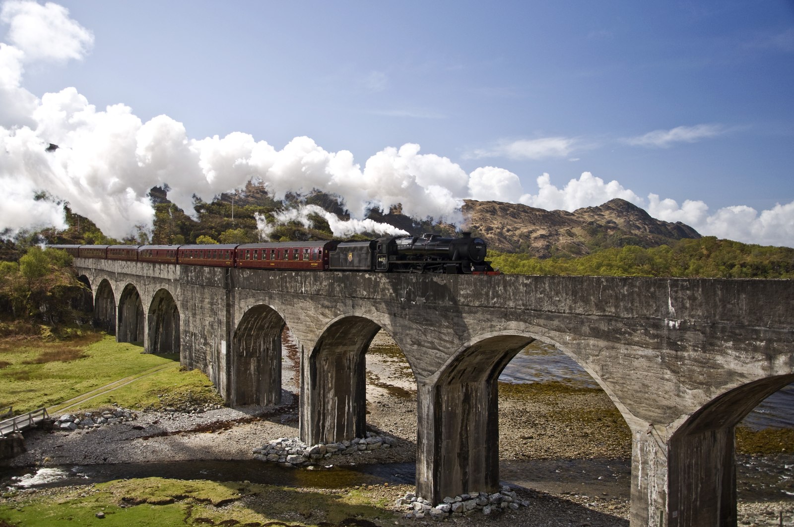
The title of this article may raise an eyebrow as it looks at a viaduct and the tomb of a horse. How do these two go together? I ran accross this documentary recently which explains why. It involves the Loch nan Uamh Viaduct, a railway viaduct located in the western Highlands region, in northern Scotland on the opposite end of the nearest city of Aberdeen, near the Prince’s Cairn. Construction started in 1897 and was completed four years later. Robert McAlpine and Sons were responsible for the design and construction of the bridge, which has eight 50-foot spans, a center pier equally divides the number. The construction did not go without a tragedy, for as you can see in the documentary below, a horse fell through one of the cassions that was being filled with concrete, hence the term bridge with a horse’s tomb. How this happened and what it took to confirm the legend are explained here:
The bridge continues to serve rail traffic to this day, but primarily for tourism. The region where the bridge is located has a lot of possibilities for hiking. Whenever you get the chance to visit the region, check this bridge out. The bridge has a unique history and with that, the story of how the horse was buried in the bridge, a tragedy that truely is considered a once-in-a-lifetime event.
Our next pic of the week features a huge eye watching you- the truest meaning of Big Brother. 😉 Marrius at Snap by Matt took this unique photo of the stone arch bridge, spanning one of the canals in the city park in the city of Riga, the capital of Latvia. Riga has a lot of unique bridges both spanning the River Daugava and crossing the canals that serve the city of 630,400 inhabitants. There are several tour guides to show you the bridges the city has to offer; one of which can be found here and also here.
This bridge, however, is unique because of its setting, combined with the perfect motif for photography at night, as you can see here. When visiting Riga, one should try this shot: a bridge with an exact mirror reflection on the water. Its blue lighting on the arch, combined with the arch itself- lighted in white LED- makes it look like an eye is arising out of the water. One film that has a similar feature to this one is a fantasy film entitled Krull, released in 1983 and marked the high point for American film actor Ken Marshall, who played the character Colwyn who, together with an army of bandits, sought to free his love, Lyssa, from the grapples of the Beast, who had kidnapped her during a raid at the beginning of the film and imprisoned her in the eye of the teleporting castle. The eye had a pupil that served as a gate but also as a screen that showed what was happening as the army marched towards the castle to rescue her. The blue presented was for the frame. While it received bad reviews at first, it has become a cult since then.
The bridge may not be as popular as the the ones along the Daugava, but it serves as a hidden gem for tourists and photographers alike. It should be added to the list of places to visit while in Riga. The city is famous for its wooden and art noveau architecture as well as its Medieval historic old town. But it has a lot of bridges that deserve a visit and a shot with the lens.
Apart from the Railroad Arch Bridge, this stone arch bridge, dating back to over a century ago, deserves a visit, too. 🙂 ❤
In our next mystery bridge series, we head to the city of Hamburg. With over 2400 bridges in the Hafen City and German City-State of 1.5 million inhabitants, Hamburg has more bridges than Pittsburgh, more bridges than Venice and even more bridges than Germany’s capital of Berlin. Each bridge originates from not only a different district but also a different time era, which includes structures that had survived World War II. When visiting Hamburg, if you want to photograph the bridges, you either need to stay a month to get each and every single one of them, or visit the most famous of them.
There is a webpage that focuses on Hamburg’s bridges entitled Hamburger Brücken. The site features each of the city’s most prominent bridges as well as some fancy ones, many of them feature a unique design, let alone a unique history. You will find the links at the end of this article and some bridges from there will be featured here in the future.
This bridge caught my attention for many reasons. It’s a rather unusual through truss bridge that features an endpost that is half slanted-half vertical. Its portal bracing resembles that of a trio of bridges in Montana: The Fort Benton, the Forsyth and the now extant Fort Keogh:
Fort Keogh Bridge in Custer Co, Montana. Photo courtesy of HABS-HAER-HALS
.
Though the bridge in Hamburg appears to have Pennsylvania truss design features like in the three aforementioned Montana crossings, it’s highly doubtful that any of William S. Hewett‘s relatives would make the trip overseas to Germany with the possible exception of fighting the Nazis in World War II and rebuilding Hamburg afterwards as the city became part of the British-controlled zone, which later consolidated with the Americans and French.
The bridge is located in Steinwerder, one of the districts in the center of Hamburg and used to span the Steinwerder Canal. The canal was 750-800 meters long and used to connect the north and south channels of the River Elbe. It was emptied and partially filled in in the 1990s. Since then, the bridge has been sitting on ground, fenced off and its future unknown. The canal was built after World War II which means the bridge dates back to that period, especially because of the thick metal beams and riveted connections.
The question is who built the bridge? When was it built? And what type of truss is this bridge? And lastly, is there a way to reuse the bridge? A discussion that can be made via Hamburger Brücken’s Instagram page. Otherwise, feel free to comment on the Chronicles via facebook or in the comment section. Some cool facts about this bridge would be quite useful and serve as an incentive to possibly save this unique structure.
De Hef Lift Bridge in Rotterdam: To be dismantled to allow for Jeff Bezos’ Multi-Story Yacht to pass. Source: elm3r, CC BY 2.0 https://creativecommons.org/licenses/by/2.0, via Wikimedia Commons
.
.
To listen to the podcast, click here for Anchor or here for WP version
This is a blog about my project of visiting every bridge over the Genesee River and what I learned about the history, structure, and natural surroundings of each bridge.


