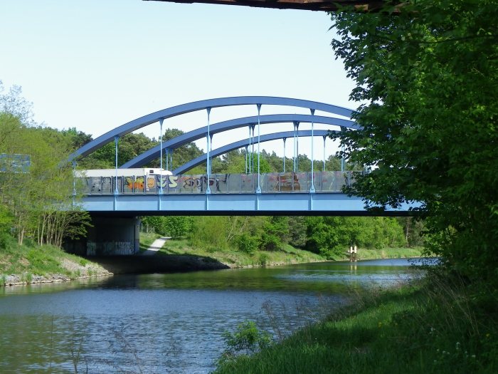
The next tour guide being put together will be the historic bridges in Waldheim. Located northeast of Chemnitz in the German state of Saxony near the town of Frankenberg, the community of 8,500 inhabitants has a typical small-town environment with a small but lively town square, many historic buildings and churches and lots of greens, all along the River Zschopau. The town also has an unusually high number of large viaducts and historic bridges, all over 130 years old at least, and therefore, one needs to spend a day there.
Here’s a preview of the tour guide beginning with this viaduct. It spans a deep valley occupied by Waldstrasse and a small creek north of Waldheim. Built 160 years ago, the viaduct is 60 meters tall and 600 meters long. It is the first place of interest when entering Waldheim. The viaduct still serves traffic today as regional trains between Chemnitz, Döbeln and Riesa daily. While not having crossed the bridge by train, one can believe a nice beautiful view of the river valley and Waldheim itself while traveling through. Yet there are more of these to go around…..
Situated on Vancouver Island and now part of the Trans Canada Trail, this bridge was at one time a vital part of getting logs down to the mills.
For the complete story, please see my blog of May 6, 2018, entitled Wandering Vancouver Island – Kinsol Trestle.
This is a picture of the Hudson Hope suspension bridge spanning the Peace River in northern British Columbia. The steel cables that hold up the deck are buried in bed rock and cement, 53 feet below the surface.
The haze in the background is smoke from many of the forest fires in B.C. this past summer.
Located in Nanaimo, B.C., this bridge, for walking only, forms part of the water front attraction that runs for several kilometers. It is well lit at night, and is a popular area at all times of the day. Cheers.
Travelling along the Autobahn 115 heading into Berlin, one will be greeted with a lot of surprises in a form of relicts from the Cold War Days. Even abandoned buildings, lighting and pieces of the Berlin Wall have managed to remain in place after almost 30 years since the Fall of the Wall, which created the domino effect for the rest of eastern Europe and resulted in a reunified Germany. Some examples of such relicts include those at Checkpoint Bravo, located at the former border splitting Berlin into two at Dreilinden-Drewitz.
This slideshow requires JavaScript.
From 1969 until 1991, this was the former transit point for all cars entering West Berlin from the rest of East Germany. Patrollmen inspected the vehicles for dangerous goods- those on the East side for those wishing to smuggle themselves to the West at any cost. Restaurants, gas and service station, customs office and holding stations, all of which were the works of the architect mastermind Rainer Rümmler, flanked the Autobahn, which was christened the AVUS Transit during those days. Relicts from the past still exist today but are partially occupied by administrative offices serving Berlin and the rest of Europe. One can witness the eery feeling of emptiness combined with nostalgia when walking across the former complex that had greeted thousands passing through daily.
This slideshow requires JavaScript.
Yet, when looking 2 kilometers to the west, one will see relicts of another former crossing and bits and pieces of the older Autobahn, including a bridge spanning the Teltow Canal. This one has an even more adventuresome history which will be discussed in this tour guide on the bridges at Checkpoint Bravo. To give you an idea what we are looking at, let’s have a look at a pair of maps to help you:
To get there, there are several ways. By car, one can park at the former Checkpoint Bravo site or at some of the parking areas in the Düppel Forest, including the Campground Camping Freude Berlin, located on the south end of Teltow Canal. The nearest lightrail (S-bahn) and rail stop is Griebnitzsee, yet it is recommended to use the bike to get to the site because the former site is 2 kilometers to the east- that is unless you’re training for the Berlin Marathon, then you can afford the trek into the wild. 😉
I took the rental bike during my stay in Berlin and detouring past the US Consulate in Charlottenburg, I took the chance by biking down there to see the sites that belonged to one of the most important sites in post-war German history; second behind Checkpoint Charlie in the city center. After spending a couple hours there, one can conclude that Checkpoint Bravo and its sites are definitely worth a field trip for any history class in school. We’ll have a look at the reasons why beginning with……..
….this bridge.
AVUS Bridge at Teltow Canal
This bridge is the piecemeal of the former East-West Berlin crossing from the southwest. The deckplate girder crossing is about 150 meters long and dates back to 1940. It was part of the first Autobahn that was built in Germany, dating back to 1922. From Funkturm in the city center to Grunewald, the motorway, known as AVUS, was solely used for car racing and for testing automobiles until the time of the Third Reich (1933-45) when they decided to use it for transporting people and goods while at the same time, extend the route to the south. The first segment connected the three-leaf interchange Nuhetal (with A-10 Berlin Ring) with the four-leaf clover interchange Zehlendorf in 1940. The second extended to the southern end of the race track and was completed in 1941. Counting the interruptions because of the last few months of the Second World War and the march on Berlin in 1945, the northern half of AVUS was used for autoracing until 1998. The AVUS Bridge at Teltow Canal, a.k.a. the Dreilinden Crossing was considered throughfare until after World War II, when Berlin was divided into West and East. Prior to Germany’s defeat, the Nazi soldiers had blown up the crossing to slow down the advancing troops. From 1948 onwards, the Dreilinden Crossing was considered a border crossing and would continue to function as that until 1969, when the East German government decided to shut down the border crossing and as a reaction, the West German government constructed Checkpoint Bravo. Prior to its closure, when people tried crossing between West and East, they were greeted by a restaurant, campground, car parking area and crossguards with patrol house. On the west end, there were flag posts where the flags of West Germany, the Allied Countries and Berlin once waved proudly. The flag post, road signs leading to West Berlin, a few street lamps and the bridge itself are still there today. The restaurant and campground have long since closed and are privately owned. The bridge used to be blocked off during the Cold War with the wall going right across the structure. That was subsequentially removed after the Fall of the Wall. Today, one can use the bridge to cross Teltow Canal and see some of the sites of what used to be the Dreilinden border crossing, but will not be able to see the restaurant and campground. The structure has been considered a historic landmark because of its association with the Cold War and the history of the AVUS. Ironically, the AVUS is the second oldest motorway in the world; the first one was built in 1921 in Italy (Milan-Laghi Autostrada) and was used exclusively as the motorway we know of today. AVUS was solely used as a testing ground and racetrack until 1935.
This slideshow requires JavaScript.
********
This slideshow requires JavaScript.
AVUS/Stammbahn Underpass
As many as four bridges used to span the original stretch of the AVUS from the time it was built in 1940 until the time the autobahn was relocated and the Dreilinden border crossing closed in 1969. This bridge is all that is left today, as it still spans what is left of the route. The bridge consisted of two railroad crossings, although given the unusual width of the brick piers, it might have for one time carried a street or multiple rail lines. However, records show that this bridge was a railroad crossing that carried the original Berlin-Potsdam-Magdeburg Railroad (BPM). The line was created in 1845-47 and used to run through Zehlendorf and Düppel. The rail line also included an S-bahn line that ran parallel between the BPM Route and the AVUS. The line survived for almost 120 years until two events sealed the fate of the Zehlendorf-Griebnitzsee portion of the BPM. The first was the construction of the Berlin Außerring in 1956, which rerouted all train service through Berlin-Wannsee instead of Düppel, Machnow and Stolperweg, all of which ran parallel and across the East-West German border. The second was the construction of the Berlin Wall and the strikes that followed. With the two developments, the line between Griebnitzsee and Düppel was cut off, and the original line was shut down by 1980. Relicts of the line still exist today including this bridge, whose remaining span consists of a single-track steel plate girder span, with an estimated length of 100 meters across the former AVUS. The other spans were removed and reused on other rail lines. Since 2000, there have been talks of revitalizing the original line yet the earliest they will be able to start rebuilding and reopening the line is 2030. While walking past the bridge, one will be greeted by grafiti that covered virtually the entire bridge and piers. 200 meters away of the bridge is a memorial for one of the victims who tried escaping to the western half but was shot on site by East German border guards.
On 15 June, 1965, businessman Hermann Döbler and his partner Elke Märtens were on a boating trip from Wannsee to Griebnitzsee when they tried to escape to West Berlin via Teltow Canal. The canal was heavily guarded by patrolmen on the East German side to prevent people from escaping. Still the two took the risk and tried to cross, only to stop 100 meters short of the border and turn around. As Döbler was turning around, two patrolmen opened fire on the boat, hitting him four times in the knee, torso and head and killing him instantly. Elke suffered a grazed bullet in the head but survived with permanent injuries. Döbler had tried to help others escape and even wanted to escape to the west after he was separated from his family because of the Wall. His family was already in the western half of Germany when the Wall was built. The person who shot him was later arrested in 1993 and convicted of murder. He was sentenced to six years in prison.
Friedhofsbahnbrücke
The Friedhofsbahnbrücke is one of a few well-known relicts left of the train line that connected Berlin-Wannsee and Stahndorf. It was one of two light rail crossings over the border between West and East Berlin during the Cold War. Yet the bridge and the line go back a century. The Baltimore through truss bridge with riveted connections and closed heel bracings was built in conjunction with the creation of the line in 1913-14. While the line survived the first World War, it sustained considerable damage during the second World War, with the light rail stations, much of the 4.2 kilometer track and this bridge itself being destroyed before the end of the war. Attempts to rebuild the line were difficult for the bridge and the tracks were rebuilt, but tensions between the West (USA, France and Britain) and the Soviet Union resulted in splitting Berlin into West and East. Despite attempts to create a border crossing at Wannsee, connecting Stahndorf, the erection of the Berlin Wall in 1961 sealed the fate of the line, for the lone crossings left were at Drewitz (by car) and Wannsee (by train and light rail). During the 1970s and 80s, both governments dismantled the tracks, bridges and Train stations for they were rendered useless, plus for the western half, they wanted to renaturalize the area. Attempts to reactivate the line via petitions by the church organizations and locals during the 1990s fell on deaf ears because of the lack of financial feasibility of the line. Today, only small sections of the line on the former western end exist, together with a couple bridges, including this one.
This slideshow requires JavaScript.
Sadly though, the days of the Friedhofsbrücke are numbered. In 2013, the German Railways (Die Bahn) announced the removal of the bridge for safety reasons, citing the fact that because of its decades-long abandonment, combined with weather extremities and boat traffic passing underneath, the bridge has rusted and corroded to a point where rehabilitation was no longer an option. At the same time, the bridge and the property surrounding it was put up for sale in hopes to unload its liability. Up until now, there is no word as to whether the sale was carried out. During my visit in 2018, the bridge was still standing but the entire decking has been removed, leaving the 200-meter structure all but a superstructural skeleton. Combined with the extreme rust and corrosion on the structure, chances are likely that the bridge will be gone before 2020 latest. And with that, the remains of the Friedhofsbahn that had once benefitted the growing population of Stahndorf. The locals today still don’t understand the reasons for the line’s death nor the logic of the Bahn. Yet with German logic, there are some things that we don’t understand.
Author’s Note: After the visit, the abandoned bridge was removed at the end of November, 2018. The government of the affected suburbs agreed that the bridge was a safety hazard. It was taken off its piers and lowered onto a barge on the canal, before it was hauled away for scrap.
Autobahn 115 Bridge
Only 300 meters east of the Friedhofbahnbrücke, one will find the A115 Bridge. Consisting of a single-span tied arch span with three arches, built in a 40° skew, this 150 meter long span is located 250 meters south of the exit Dreilinden and Stolperstrasse. The structure was built in 1995, replacing a steel girder span that was built at the same time as the realigned Autobahn, which was built between 1967 and 1969. Because of the increase in traffic volume, especially after the Fall of the Wall in 1989, the steel structure was no longer able to handle the load and was therefore replaced. The arch bridge was built to the east of the old structure before it was slid into place at the expense of 60s structure. The bridge carries six lanes of traffic and still accommodates large sums of traffic without any problems to this day. And it is a good thing too, for Berlin has been growing by about 3% daily, especially in the outer suburbs. When entering Berlin from the south, one should exit at Dreilinden/ Stolperstrasse and turn left. There, one will find a museum with the name Checkpoint Bravo at the site of the former East German border crossing at Dreilinden and watchman’s tower. The crossing was built in 1969 when the AVUS was relocated and was preserved in 1998 and converted into a museum, where one will see a gallery, depicting the history of Checkpoints Bravo and Dreilinden and the way of life prior to 1989. One can learn more about this historic site by clicking here.
This slideshow requires JavaScript.
Königsweg Friedhofsbahn Overpass
The next bridge is very hidden- so hidden that in order to get to the structure, one has to get down and dirty and fight through the vegetation and rock climb his way down to get to the structure. And even then, it is recommended to do that in the winter time, when all the leaves are off the trees, and one can see the former S-bahn and bridge up close. The bridge is located parallel to the old AVUS, with the trail it carries running parallel to the highway before merging with the current Autobahn A 115 in the direction of Berlin. In the opposite direction, one will find it on the right-hand side of the former AVUS (about 100 meters away) before the Autobahn curves left in the direction of the former checkpoint at Dreilinden. The structure is a single span, closed spandrel, concrete arch Bridge spanning the former track of the Friedhofsbahn with a span of approximately 40 meters. With only one track, one span is logical, otherwise with two or more, one would have either added another arch span or, as practiced with most railway spans in Berlin, a through truss span. Even though we don’t know wo built the bridge, the arch span dates back to the time of the building of the S-bahn and has survived years of war, abandonment and weather extremities for over a century without a scratch. It carries Königsweg, a minimum maintenance road used mostly as a bike trail and pedestrian path connecting Griebnitzsee and Checkpoint Bravo. Sadly though, the bridge has seen better days for there is a restricted weight limit of 16 tons. Furthermore, the lane has been reduced to one lane to ensure that one vehicle can cross at a time. It is unknown how long the bridge will be in service before something happens to it. Even though track remains of the Friedhofsbahn can be seen at the bridge, chances are very likely that the span will be removed and the crossing filled in for the Bahn has shown no interest in reactivating the line, despite pleas from communities affected to have the Bahn reconsider.
Approximately 1.5 Kilometers to the east of the arch bridge is the newest of the crossings at the former Checkpoint Bravo and Dreilinden sites. Built in 1998, this bridge is located only 70 meters south of the “Hausbrücke” at Bravo and Features a rare form of a suspension bridge- a steel plate girder bridge that is supported only by the towers and no cables. An additional pier in the middle of the Autobahn is also included to provide stability for the structure, whose length is 61.2 meters and height is 1.65 meters. The architect for the bridge was Benedict Tonon, who had left his mark in Berlin with three other bridges: Marschallbrücke, Anhalter Steg and Hiroshimasteg. Krupp Steel (part of Thyssen Krupp) built the superstructure. While the bridge is obstructed by the Hausbrücke on the north end (unless one is inside that Bridge), one’s best shot for this bridge is on the south end or on the structure itself. The Königsweg was needed for the previous structure, built in 1940, was too short for the city’s plan to widen the A-115 from Potsdamer Chausee and areas to the south in Babelsberg and Potsdam. The 1940 structure, a concrete girder span, used to serve traffic to the residential areas nearby, which were popular during the days of the Cold War. After the Fall of the Wall and German Reunification, many West German residents abandoned the housing areas for newer and better properties in the former East, leaving some parts of the area to renaturalization. Today’s bridge, together with the next one on the tour guide, serves six lanes of A-115 at Bravo, but is mostly used for cyclists and hikers, while only a handful of cars pass through here.
Bridgehouse at Checkpoint Bravo
Apart from the Border Crossing Bridge over the Teltow Canal at Dreilinden, the Bridgehouse at Bravo is the second of the two masterpieces that depict the history of the East-West Berlin crossing at Checkpoint Bravo in full Detail. Like at the Dreilinden crossing, the Housebridge is part of the border Control complex that was built from 1968 to 1972 and was primarily a military base for American troops for over 20 years. It is located only 70 meters south of the Königsweg Crossing, approximately half a Kilometer south of the Potsdamer Chausee interchange, the first Exit when travelling through what was the former West Berlin. During the Cold War, travellers entering East Germany from West Berlin were greeted at Checkpoint Bravo, where their cars were thoroughly inspected to ensure there were no harmful materials that could cause unrest between East and West. Lines of cars along the AVUS were the norm and many had to wait either in waiting rooms at the customs Office or the holding rooms as well as at restaurants located on both sides of the AVUS. Westerners were allowed to enter and leave East Germany, whereas the East Germans were banned from entering West Berlin, as it was part of West Germany. There were many attempts to escape to the West from 1961, when the Berlin Wall was erected, until 9 November, 1989 when the Wall fell and the gates were opened to those who want to see it. Yet during that time, Checkpoint Bravo was also involved in (nearly) successful attempts of smuggling East Germans into West Berlin (and with that, the West).
One needs to remember that along the AVUS, there were two border crossings from 1969 to the Fall of the Wall: the East German border crossing at Checkpoint Bravo, located at the site of A-115 Bridge over the Teltow Canal and the West German border crossing at Checkpoint Bravo, which is this one. One needs to pass through both to cross. Both sites are considered historic monuments yet the Housebridge and the West Berlin side of Checkpoint Charlie was auctioned off, together with the restaurant in 2010. The Bridge, which was designed by Rainer Rümmler und Hans Joachim Schröder, together with the rest of the complex, is still standing and serves as a greetings and entry point to Berlin. The complex is still used for film scenes, yet there are no plans for converting at least part of the complex- bridge included- to a museum just like at the one at the East Berlin part of Bravo at Stolperstrasse. Yet anything is possible and it is doubtful that the whole complex- still preserved in ist original pre-1989 form- will disappear anytime soon, for Checkpoint Bravo is still a key part of the history of Berlin, Germany, Europe and the Cold War period, where the US and Soviets faced off for four decades until 1989.
Fazit:
After spending a couple hours by bike and by foot, I found a lot of interesting facts that made this area around Checkpoint Charlie a unique place to visit. While many people prefer a tour guide with simply fancy historic bridges with some historical facts and all, sometimes bridges play a role in the history of the region and possibly the country. The bridges at and around Checkpoint Bravo symbolized the need to connect East and West Germanys as well as Berlin. for the Wall and the division resulted in families being split up and enflamed conflicts between the US and its allies on one side and the Soviets and their Warsaw Pact countries on the other. And even though attempts to keep people from fleeing through Walls and patrol guards were made, one can see that when there is a will, there is a way to circumvent the barriers and bring the sides together. Officials in Berlin on all levels have been working to keep the relicts of the former Berlin Wall from either falling apart or being removed in favor of modernization for reasons that this part of history should not be forgotten. Already, the mentality is “History is History, We worry about the future” is starting to set in, especially with the younger generations. Therefore, it is important that such artefacts are kept in place and restored with the goal of ensuring that this part of German history is not forgotten forever. The Bridges at Checkpoint Bravo is part of that history, which together with the former crossings at Bravo and Dreilinden, people should understand about. After all, in order to learn about what is going on in the present which is effecting the future, one needs to look into the past to determine what actions that were done then can still be used now in order to have a future for younger generations to enjoy.
After leaving Moab, we headed to one of our favorite parks we encountered on the trip, Natural Bridges National Monument. It sits in a high desert environment, with elevations of 5,500-6,500 feet and average yearly precipitation of 13 inches. As the park is somewhat off-the-beaten-track, we only had time to visit this one and Hovenweep […]
Century-old, two span pedestrian bridge to be part of new bike trail.
AUE (SAXONY), GERMANY- Back in March of this year, many hikers were irritated with the fact that their favorite crossing over the Zwickau Mulde, connecting Bad Schlema with points to the east and south, was closed to all traffic. They were forced to take a detour 3-4 kilometers away or even ditch the notion of going by foot and driving by car. Since the beginning of this month, the Iron Bridge has been in use again, six months after it was closed to traffic. The two-span Parker bowstring arch bridge spans the Zwickau Mulde and was built in 1900, replacing a covered bridge that was destroyed in a flooding. And while the truss superstructure remains the same as is, some work was done on the bridge to ensure that it is safer for use, even for cyclists. For instance, new railings were installed to ensure that no one falls off the bridge. At 1.5 meters high, they are 0.5 meters higher than the originals. Furthermore, new acorn-colored varnished wooden decking replaced the previous one that was developing cracks and dry-rot after years of extremities due to weather. The decking is thicker and will be able to withstand stresses caused by increased in traffic by bikers and pedestrians.
The rehabilitation is part of the project to construct the Mulde Bike Route, taking it off its current path that shares a street connecting Bad Schlema and Aue and running it along the river. At the same time, the Carlsbad Route is being extended, which will cross the bridge and end at Bad Schlema at the railway station. Currently, the bike trail starts in Carlsbad (Karoly Vary in the Czech Republic), and after going through the mountains and over the border at Johanngeorgenstadt, joins the Mulde Bike Trail at Wolfsgrün and terminates in Aue. Despite the completion of the rehabilitation, which costed approximately 430,000 Euros, the realignment of the trail, combined with a new bridge over the rail-line Zwickau-Aue, a new picnic area on the eastern side of the Iron Bridge and the rehabilitation of the Stone Arch Bridge at Bad Schlema will delay the completion of the entire project until 2020, at the earliest. Therefore the bridge will continue its local traffic until then, and people will have to put up with vehicular traffic along the original route along the Mulde.
The Chronicles will continue to keep you posted on the latest regarding the project.
This Pic of the Week takes us to Minnesota, where I was born and raised, and to another bridge used for target practice: The Broadway Avenue Bridge, spanning the Minnesota River, carrying MN Hwy. 99 in St. Peter, located 13 miles (26 km) northeast of Mankato.
Built in 1931, the 400-foot long span features Siamese Pennsylvania through truss spans, molded together to make it one span. The Howe-lattice portal bracings are skewed by 10°. The bridge was rehabbed recently, as a new coat of paint was added, along with new decking and lighting. Yet despite this, the bridge looks somewhat the same as before, minus the color change. Have a look at the difference and see what you think. I’ve stopped at the bridge at least five times for a photo opp. The shot taken before the rehab was in 2013. The shot after the rehab was in July 2018, six months after the rehab was completed. Enjoy! 🙂
Before
After
You can click on the link above to see what else they have done to see for yourself. 🙂
Welcome back to National Parks & other public lands with T! If you are seeing this on Twitter or Facebook, please visit the blog to see all of the photos and read the story by clicking the link. The Natural Bridge in Virginia was a great stop on our road trip to the Great Smoky […]
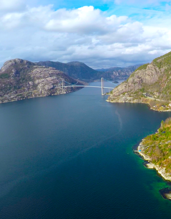
My daughter Line Newermann, a Norwegian drone photographer, has taken this image of the Lysefjord Bridge. The Lysefjord is the fjord that the famous Pulpit Rock is located along. Drone: 3DR Solo, Camera: GoPro4Black
Datteren min Line Newermann, en norsk drone fotograf, har tatt dette bildet av Lysefjordbrua. Lysefjorden er den fjorden som Prekestolen ligger ved. Drone: 3DR Solo, Kamera: GoPro4Black
By Livioandronico2013 [CC BY-SA 4.0 (https://creativecommons.org/licenses/by-sa/4.0)%5D, from Wikimedia CommonsBack in January 2018, I posted a guest column on the bridges of Venice, Italy, taken by a travel blogger, who discovered the many hidden sites of Venice that are worth seeing, as a person visits the bridges along the Grand Canal and other waterways that make the city famous. A video was posted recently on the same subject, yet the focus was on the bridges themselves, filmed from all angles including the surroundings.
To give you a better idea of what to expect from the bridges of Venice, here’s the nine-minute video which will give you more than enough reasons to go to Venice. Enjoy! 🙂
“Once upon a time there were two countries, at war with each other. In order to make peace after many years of conflict, they decided to build a bridge across the ocean.
But because they never learned each other’s language properly, they could never agree on the details, so the two halves of the bridge they started to build never met.
To this day the bridge extends far into the ocean from both sides, and simply ends half way, miles in the wrong direction from the meeting point.
And the two countries are still at war.” ― Vera Nazarian, The Perpetual Calendar of Inspiration
This is a blog about my project of visiting every bridge over the Genesee River and what I learned about the history, structure, and natural surroundings of each bridge.


 Kinsol Trestle.