Fellow pontist James Baughn of bridgehunter.com found a real diamond in the rough most recently while on tour through Illinois, but one that is really fragile and could splinter if nothing is done to preserve it.
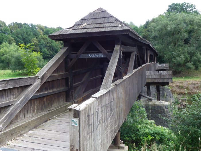
The diamond in the rough is this bridge. The structure is located at Cypress Pond State Natural Area. The bridge spans the old channel of the Cache River along what is left of a road connecting Elvira and Pleasant Grove, approximately five miles west of the nearest town of Buncombe. The road has been abandoned for decades and the only way to access it is by walking about two miles south from where Baldwin Lane ends on the northern side of the crossing. The southern side is not accessible due to corn fields and the impossibility to cross the new channel of the Cache River. Yet when arriving at the bridge, the hike is well worth it as the bridge has features that are atypical for truss bridges.
At 50 feet long, the bridge is a bedstead pony truss bridge with a Warren design. Bedstead trusses are characterized by endposts that are vertical, forming a 90° angle. Because the connections are riveted, the build date has to be somewhere after 1900. The reason for this is because riveted truss bridges made their debut at the turn of the century to replace the pin-connected truss spans because they are able to withstand increasing volumes of traffic. They were standardized by the states through different laws and regulations by 1915, narrowing the different trusses down to half a dozen and phasing out all other truss designs and the use of pinned connections altogether. The railings feature a lattice design that is inside the trusses, bolted together. This is unusual for truss bridges of its design and age, for only simple railings were used after 1900. One has to assume that this bridge was built at this location between 1900 and 1910. It is unknown who built the bridge, let alone when the structure was abandoned. For the latter question, it may have happened at the time when the Cache River was rechanneled, which we don’t know when it happened.
The problem is the bridge is falling apart due to nature’s wrath. In other words, if nothing is done to relocate it and restore it in due time, the bridge will surely collapse into the river. Problems that James Baughn saw during his field visit included the fact that the bridge has no decking left but just the bottom chord that is hanging by a thread over the river. The entire bottom chord has corroded away to a point where it and the trusses themselves could fall into the river. The support is pretty much gone. Furthermore, the northern endposts have sustained damage in a form of twisted and corroded beams. This was caused by a shift in the river current, combined with erosion and other elements. In addition to the damage on the north side, a tree is growing right through the chords, thus causing damage to the stringers. On the south end, it is not much better as erosion was dominant and undermining the abutments to a point where they could fall into the river upon the next flood, along with the trusses themselves.
To make it short, time is of the essence to pull the bridge out and find ways to reuse it. Potential for restoring the bridge is possible but it would require extensive work with sandblasting and replacing the beams. Ideas on how to approach this delicate project should be referred to the county officials in Johnson County as well as some of the bridge companies that are experts in bridge restoration, like Workin Bridges and BACH Steel, as well as Mead and Hunt. Even if the flooring system is not salvageable, which appears is not the case, the trusses could be used as ornamental railings for a new bridge.
But as mentioned before, time is of the essence, as well as the interest. When there is a will to save this bridge, there will be a way, especially as it has a lot of history to be looked at in connection with the Cache River and the county itself.
Check out James Baughn’s page with some more info and photos he took of the bridge here.
ERLA-CRANDORF (SAXONY); GERMANY- Not far from the towns of Markersbach and Schwarzenberg is our next mystery bridge. This one is located over the Schwarzwasser River in the small town of Erla. First mentioned in the history books in 1308, Erla and its neighboring village Crandorf are located three kilometers southwest of Schwarzenberg. Combined, they have a population of only 2000 inhabitants, with Erla having 850. The two communities had been a joint entity from 1925 until it became part of the Schwarzenberg consortium in 1999, which remains to this day. While Crandorf is located on top of one of the mountains in the Erzgebirge, Erla is wedged deep in the Schwarzwasser Valley and is easily accessible by rail and by highway, both leading to Johanngeorgenstadt, which is at the border between Germany and the Czech Republic.
This bridge is one of the most unusual through trusses one can visit. It is located 50 meters from the train station and right next to the steelworks, which has existed as long as the community. When looking at the bridge from a distance, it appears a duo span that are siamese twins, meaning one truss bridge is connected to a larger truss span. Upon further view, the bridges are indeed separate, but the spans are different in size and age. The only similarity is that they are both Warren trusses with subdivided vertical beams, yet the larger one has a Scharper design.
The larger span features a through truss span with a 45° skewed portal bracings, which stretches three panels on the right side of the truss. Both the portal and the strut bracings are I-beamed shaped, while the first left panel has a vertical bedstead endpost and 60° heel bracings supporting the first strut and the portal bracings. All beams are mainly I-beam, with the vertical beams being H-beam. All connections are riveted. Every panel has a heel bracing on the bottom end of the decking. The bridge is 25-30 meters long and about 10 meters wide. It is taller than the neighboring pony truss bridge by 2 meters. The bridge is much newer with the only engraving being the name of the steelworks company, the Friedrichshutte, based in Laubach (Hesse), which is east of Frankfurt (Main). It is very likely that the bridge was built after German Reunification and is between 10 and 20 years old. But when it was built is unknown.
It is just as unknown as the pony truss span located right next to it. The bridge is definitely older, yet the question is how old. The Schwarzenberg-Johanngeorgenstadt-Karlsbad route was built in 1883, and the railroad was rerouted between Erla and Schwarzenberg in 1946, which included the elimination of the tunnel going underneath the castle in Schwarzenberg. The chances of the pony truss span being built during Communist times is likely as riveted and welded trusses began to take over trusses with pinned connections in 1910. Bridges built to replace those destroyed during World War II were built using this type of connections on the trusses. This pony truss bridge has welded connections as it was built using T-beams. Even the gusset plates are welded into the beams making it sturdier. What is unique about the pony truss span is its unusual skewed span. It appears that the skew is 60°+ or misaligned by four panels, which makes it unusual for a skewed truss span. The vertical beams feature a pencil-like thin trapezoidal design, where the beam’s width is 25 cm, yet the beams narrow to form a pencil chewed on both ends- with 40 cm from the top and 25 cm from the bottom chord. The truss is 2 meters tall and the width is about eight meters. Because of its age and narrowness, it was subsequentially replaced but never removed. Even though it has been fenced off, it appears that a bike or pedestrian trail may be in the works in the long term, especially as there is a bike trail already in existence between Aue and Schwarzenberg. If it is the case, it may be an advantage for those wishing to bike up the mountains.
A photo gallery of the two bridges is below. If you know more about the bridges, feel free to contact the Chronicles. The main questions to be answered are: What more do we know about the history of the bridges? What did they look like before 1945? When were the two bridges built? And in the case of the pony truss bridge, who was the bridge builder? Any ideas and help would be much appreciated.
Photo taken by K.A. Erickson in 2009 before it was replaced.
Washington DOT (WSDOT) will pay up to $1 million for the dismantling, transporting and reassembling of the 1925 through truss bridge to be reused for any purpose.
TACOMA, WS- Sometimes historic bridges get into the way of progress and need to be replaced. This is especially true with bridges whose height, width and weight restrictions hamper the ability to get trucks and other means of transportation across. However, before they are removed, states are required to put them up for sale so that third parties can claim them and relocate them the way they see fit. In general, the bridge program has had a mix of successes and failures in selling off their historic assets, for on the one hand, third parties wishing to purchase the historic bridge for use are shirked away by the cost for transportation and reassembly. Furthermore bridges marketed by the department of transportation are often too big or in the case of arch, beam and suspension bridges, too entrenched or too fragile to relocate. On the other hand, however, one will see in each state a success story of a historic bridge that was given to a third party. This is especially true with truss bridges as they are easily taken apart, transported to a new location in segments and reassembled. One will see an example in every state, yet Indiana, Texas, Iowa, Ohio and Minnesota have multiple examples of success stories. Even some stone arch bridges have been relocated to new sites where they still serve their purpose.
However, there is one state department of transportation that is going the extra mile to sell their historic bridge by even paying for the relocation and reassembly of the historic bridge. Between now and 2019, the Washington Department of Transportation (WSDOT) can sell you this historic through truss bridge:
According to the information by the WSDOT and bridgehunter.com, this historic bridge was built in 1925 and used to cross the Puyallup River at State Highway 167 (Meridan Street) in Puyallup, located seven miles east of Tacoma, until it was replaced in 2011 by a modern crossing. It was then relocated on land, where it has been waiting for its new owner ever since. Washington has got a wide array of historic bridges, whose unique design makes it appealing for tourists. They have the Tacoma Narrows Bridge (with its name Galloping Gertie), the , the world’s only concrete pony truss bridge, and a housed through truss bridge made of wood in Whitman County that was once a railroad crossing, just to name a few. The Puyallup Bridge is a riveted Turner through truss bridge, a hybrid Warren truss design that features subdivided chords and A-framed panels. After the demolition of the Liberty Memorial Bridge in Bismarck, ND in 2009, this bridge is the last of its kind and one of two of its design left in the world- the other is a Turner pony truss crossing in the German city of Chemnitz. Normally, going by the standard marketing policy, the historic bridge is marketed first before it is replaced and then taken down if no one wants it. However, looking at that tactic done by many state DOTs, this has not allowed much time for third parties to step forward and save it, especially because of the costs involved. For some bridges, like the Champ-Clark Truss Bridge, spanning the Mississippi River at the Missouri-Illinois border, there was almost no information about the bridge being up for sale as well as a very small time window of three months, thus providing no interest for at least one of the spans. According to MoDOT representatives in an interview with the Chronicles a couple months ago, the spans now belong to the same contractor building the replacement, who in turn will remove the spans when the new bridge opens in 2019.
The Pullayup Bridge is different because of its large size and rare design, which goes along with the history of its construction. It was built in 1925 by Maury Morton Caldwell, a bridge engineer who had established his mark for the Seattle-Tacoma area. This event was important for its completion came at the heels of the introduction of the US Highway System a year later. Born in Waynesboro, Virginia in 1875, Caldwell moved to the Seattle area in 1904. He worked as a civil engineer for the City of Tacoma from 1910 to 1916 before starting his own engineering business. Prior to the construction of this bridge in 1925, Caldwell had been responsible for the construction of the Carbon River Bridge in 1921, the Pasco-Kennewick Bridge in 1922 and the Wiskah River Drawbridge in Aberdeen in 1925. Yet the 371-foot long Pullayup Bridge proved to be one of his masterpieces that he built in 1925, thus leaving an important mark on his legacy of bridge building in the Seattle-Tacoma metropolitan area. It is unknown how many other bridges were credited to his name, but from the historic research conducted by WSDOT, he was never a licensed professional engineer for Washington State and only practiced the profession for the Seattle-Tacoma area, which means the highly likelihood of more bridges having been designed by Caldwell and located strictly in north and western Washington and possibly British Columbia. He died in 1942, having been survived by his wife, Amy, whom he married in 1915, and his sister Nettle, who resided in Virginia state.
The Pullayup Bridge is being offered to those interested by WSDOT between now and 2019. The catch to this is the DOT will pay for the dismantling, relocation and reassembling costs- up to $1 million for the whole process. The only cost that the party may have to pay is for the abutments and possibly the road approaching it. The deal provided by WSDOT is a great steal for those wishing to have a unique historic bridge for reuse as a park or bike trail crossing. Even the thought of using it as a monument describing the history of the bridge, bridge engineering and M.M. Caldwell is realistic. Some parties who have called up wished to convert it into a house, similar to one of the reused spans of the now demolished eastern half of the San Fransisco-Oakland Bay Bridge, which had been built in 1936 and was replaced with a cable-stayed span in 2013. The main slogan is if you have an idea for the bridge, WSDOT can pay for it, and you can make your dream a reality. With many successful projects, stemming from creating historic bridge parks in Iowa, Michigan and coming soon to Delaware (where historic bridges were imported from other regions) to numerous bridges along the bike trails throughout the US, Europe and elsewhere, this deal to have the bridge for free, with a transportation agency having to pay for the relocation and reerection at its new home, is something that one cannot really afford to miss out on.
If you are interested in this unique historic bridge, please contact Steve Fuchs at WSDOT, using this link, which will also provide you with more information on this structure. The agency is also looking for more information on M.M. Caldwell and other bridges that he may have designed and contributed to construction. If you know of other bridges built by this local engineer, please contact Craig Holstine, using the following contact details: holstic@wsdot.wa.gov or by phone: 360-570-6639.
Lunzernau Bridge in the final stages of construction. Photos taken in March 2017
One-of-a-kind bridge replaces a two-span bowstring arch bridge and re-establishes connection in small village in Saxony.
LUNZENAU/ GLAUCHAU- During my bike tour along the Zwickauer Mulde this year, I was greeted with new bridges that had replaced structures that were, on the one hand, damaged by flooding, but on the other hand, appeared bland and needed a makeover. After the Wernsdorf Wave near Glauchau, another bridge is making its debut, but one that restores a key connection in a small community that is nestled in a deep river valley and provides various recreational possibilities.
Enter the Lunzenau Pedestrian Bridge, also known to locals as Küblers Bridge.
This bridge is located on the north end of the town of Luzenau, just off the Mulde Bike Trail, located at Schaisdorfer Flur near Eichelberg. Biking past the bridge back in March, the bridge was already installed in place and in the final stages of completion, which included constructing the approaches and adding lighting to the deck. Since 22 June, the bridge is now in use for pedestrians and cyclists, thus restoring a vital connection between Friedrichstraße where a couple factories had once stood, and Burgstädter Straße and the park and sports complex on the opposite end.
Close-up of the truss span and wingwalls
The two-span, 75 meter bridge replaced a two-span bowstring through arch bridge that was built in 1889 and was christened the “Augustus-Johanna-Brücke,” named after the royal couple in Saxony at that time. The bridge was dedicated on 13 July that year and provided access to the factories located at Schaisdorfer Flur, where Friedrichstraße is now located. The structure had a Parker truss design with pinned and welded connections. The endposts were vertical- a rarity for bowstring Parker designs. The portal bracings consisted of a beam bent into a trapezoidal fashion, yet the struts have straight beams with 50° heel bracings. Despite being rehabilitated in the 1950s, the bridge had maintained its original form and continued use until it was damaged by floodwaters in 2013 and subsequentially condemned in December 2014. After securing funding for the project in May 2015, the contract was given in December that same year and in January, the project began with the removal of the truss spans with the crane and the demolition of the eastern approach spans and abutments. This was followed by rehabilitating the center pier and adding a new concrete foundation at the top to anchor the new spans at the center. The new approaches and abutments were built at the same time. In January of this year, the new spans were brought in by truck and installed with the crane. During my visit in March, the roadway had already been installed, as workers took advantage of the unseasonably warm weather and tried finishing ahead of schedule.
Close-up of the V-shaped towers and restored stone pier.
In terms of the bridge’s appearance, the structure, painted in red (trusses), white (railings) and blue (tower), is a real eye-opener that will surely become one of the town’s key landmarks. The bridge is a cantilever pony truss bridge, designed as a Warren truss, but having one tower, planted in the middle of the river, supporting the two spans that each extend to the abutments on the river bank. Its tower is V-shaped, extending outwards. The bridge had welded connections as the tubular steel beams were assembled together at the bridge-building firm before being carried to the bridge site by truck and put together by cranes. The bridge’s design follows the examples of two bridges: the towers mimic those of the three cable-stayed bridges being installed in New York City; the cantilever truss follows closely to the Paradiesbrücke, a more ornamental but almost 120-year old structure that spans the same river but located upstream in Zwickau. With the Lunzenau Bridge in service, we have two one-tower cantilever Warren truss bridges along the Zwickauer Mulde- a rarity in Europe and even North America- but the newer bridge is sleak and really colorful, an attraction that will get many bikers and pedestrians to stop by to pay a visit.
The dedication ceremony was met with very positive feedback as dozens gathered to cross this new bridge. This included members from the construction company that built the bridge, from the District Mittelsachsen, Mayor Ronny Hofmann and even Pastor Gerd Flessing who oversees the local church. “Without the funding, careful planning and participation of everyone in this project, this project would never have been realized,” said Hofmann in an interview with the Chemnitz Free Press. “This bridge is a real jewel and I’m thankful everyone had a chance to be involved in this.” That comment is completely true in that aspect. Those who chimed in on the structure got themselves a real gem that will be up for many awards for its design. The bridge will indeed gain from all who have seen it and recommended it to others.
This goes beyond my impressions of the bridge and my providing support for the town for this fine work. 🙂
Check out the town’s website, which has some details on its bridge and history.
Our 79th Mystery Bridge takes us to Oklahoma; specifically to Whitesboro in LeFlore County and this bridge. Spanning the Kiamichi River at Township Rd. 4044C south of Whitesboro, this bridge is one of the most unusual through truss bridges a person will ever see in the United States. According to the data from Bridgehunter.com, the total length of the bridge was 270 feet with the largest span being 127 feet, the width of the bridge is around 13-14 feet and the vertical clearance is 13.3 feet. Yet despite the date of construction being ca. 1940, this bridge is unusual as it is a pinned connected through truss, thus bucking the standards of truss bridge construction. As many resources have indicated, most truss bridges built at this time had riveted or welded connections, making the structure sturdier and able to carry heavier loads. Pinned connections had a tendency of dislocating or even having the bolts connecting the beams to break off, causing bridge failure. This resulted in many of the structures being taken off the state highway system and relocated onto less-used township roads beginning in the 1920s and extending well into the 1950s, especially as the US was lacking materials and engineers as a result of World War II. Judging by the appearance of the bridge, it appears to have been built between 1910 and 1915 as this was the cut-off period for constructing truss bridges with pinned connections. It was congruent to the time standardized bridges were approved by the state governments, which included not just focusing on truss bridges with riveted connections and either Howe lattice or lettered portal bracings (namely, A, X, M and West Virginia framed), but also the key truss designs, which were the Pratt, Parker, K-truss, Warren, Polygonal Warren and in some cases, Pennsylvania petit.
The Whitesboro Bridge features a Warren through truss, but looking at the structure further, it appeared that in its former life, it was a deck truss bridge that had many spans, totaling at least 500-600 feet. One can see how the overhead bracings were added, which consisted of thin cylindrical steel beams. Furthermore, there is no portal bracing, like other truss bridges, and lastly, when looking at the joint where the upper beam and the diagonal end posts meet, the upper beam appears to have been sawed off. According to observation by fellow pontist, Mark W. Brown, the piers are 2-3 feet wider on each side and 1-2 feet higher, thus creating a slight slope when entering and crossing the structure. Two theories go along with the piers: either they were installed when the bridge was built or they were reinforced after the bridge sustained structural damage because of flooding.
It is possible that this crossing was the first to have been built as the town expanded because of the baby boomer population. But the expansion did not last as many people moved to bigger cities for job opportunities. As of the 2008 Census, the population of the town incorporated in 1908 and named after one of the founders is only 1298. The hunch is that the highest population of Whitesboro was about 3,400 by 1960.
The Whitesboro Bridge has a design that is not like any unusual designs developed by the engineers at all. It is neither a Pegram nor a Kellogg, now is it a Schaper truss, which you can see in many truss bridges built in Germany and other parts of Europe. This bridge is definitely a repurposed truss bridge, having gone from its previous life as a deck truss spanning one of the state’s greatest rivers, like the Red and the Canadian, to one spanning a smaller river but on whose width justified a through truss span.
This leads us to the following questions:
When exactly was this bridge built and was there a previous structure?
Who was the mastermind behind this repurposing project and why did the engineer choose this?
Where did the bridge originate from?
When was this built and who was the bridge builder?
Are there other remnants of that bridge left besides the one at Whitesboro?
What do we know about Whitesboro aside the facts and figures presented in wikipedia?
Got any leads, please share in the comment sections here as well as in the Chronicles’ facebook pages. You can also contact Jason Smith at the Chronicles, using the link here. As this bridge is eligible for the National Register of Historic Places, any information you have or can find will help build a solid case for its nomination, let alone preserving it for future generations. As Oklahoma is losing historic bridges in large quantities in the past 8 years, the time is ripe to preserve what’s left of its culture, especially when it comes to unusual designs like this bridge in Whitesboro.
Special thanks to Mark W. Brown for bringing this to the author’s attention and for providing some interesting pics of this bridge.
In 1920, an American engineer, Claude Allen Porter Turner (CAP) designed two different bridge designs that were supposed to simplify the way bridges are constructed. The first was the Turner Flat Slab, a design where the decking portion of the concrete slab was strengthened, thus eliminating the need of extra piers and it would encourage the spans to be longer than usual. The second is a modified version of the Warren truss, where additional lateral beams are constructed midway through the A-portion of the truss, thus creating an A-frame for each panel. Both of these concepts were practiced on the Liberty Memorial Bridge in Bismarck, North Dakota. Constructed in 1922, the bridge featured three Turner through truss spans of 476 feet each, plus the Turner flat slab approach spans totalling 1105 feet- 625 for the west spans and 480 for the east side. It was the only known work for the engineer, whose career started at Gillette-Herzog Manufacturing in Minneapolis in 1900 but then started his own business after declining an offer to relocate to Chicago. The product of the American Bridge and Foundation Bridge Companies remained in service until its replacement in 2008. It was believed to have been the only one of its kind built…..
…..that is until this recently discovery in Chemnitz, Germany!
Located just two kilometers south of Chemnitz Central Railway Station along the Dresden-Hof-Nuremberg Magistrate at Bernhardstrasse, this pony truss span resembles the same Turner design as the Liberty, but with two unique differences: 1. The truss span is pony and 2. The endposts are vertical. Like the Liberty, the connections are riveted, even in the A-frames of the Warren. Yet some unique features of the truss include the curled cap at the top of the endpost. The end post itself has an I-shape. It is unknown what the length of the bridge is, but it is estimated to be between 60 and 70 meters long. The width is 10 meters between the trusses, the sidewalks on the outer edge is 2-3 meters, thus totaling the width of 16 meters. As the East German government built or imported truss bridges during its 40 years existence, whose designs were mainly Warren (and many modified versions of it) and had not much design to it, it is likely that this bridge was constructed during the 1920s, maybe the 1930s, and survived the bombings of Chemnitz during World War II. 90% of the city center was destroyed by 1945 and 70% of the houses and buildings, dating back to the 1800s were either in shambles or badly damaged. This bridge may have survived the bombing unscathed. Yet the lack of scars from the war might lead to a dispute over the bridge. It may have been rebuilt using replacement parts, but most likely in the late 1940s to encourage passage over the magistrate. If that was the case, then the bridge was built before the Soviets gained full control of its militarized zone, which became the German Democratic Republic (a.k.a. East Germany), while Chemnitz was renamed Karl-Marx-Stadt, a name that remained on the maps until German Reunification in 1990.
With this in mind, let’s look at the following questions to be solved regarding this bridge:
When was this bridge built?
Who designed the structure? Did this engineer use the Turner design or was it just simple coincidence?
Lastly, if this bridge is considered a Turner truss, are there other designs of its caliber that exist? If so, where?
What do you know of this bridge, let alone the Turner truss? Share your thoughts either on facebook page or by using this contact form. A tour guide on the bridges in Chemnitz is in the making and if there is enough information, this bridge will be added. Let’s see if we can solve this mystery surrounding this bridge, shall we?
Best of luck and looking forward to the findings. 🙂
500-year old covered bridge will receive a much-needed, total makeover next year.
ZWICKAU, GERMANY- It is one of two prized structures spanning the Mulde River that deserves international recognition. However, it is not only the oldest bridge in Zwickau, but the only known bridge of its kind on the globe. The Röhrensteg was built in 1535 and rebuilt to its current form in 1790 after sustaining damage in a flood. The bridge is the only structure in the world that carries two different truss designs- a Queenpost on one side, and a subdivided Warren on the other. It has two different portal bracings: the A-frame on the city end, and an X-frame on the end going to Reinsdorf. The endposts are unlike any covered bridge known to people Europe or North America. The covered bridge is the only one of its kind that carried water across the river into the city, via wooden pipes coming from a reservoir in Reinsdorf, 4 kilometers east of Zwickau.
The bridge has survived the test of time, including wars, weather extremities (including flooding) and the increase of traffic with bikes and pedestrians. And the age has shown on this structure, as shingles are missing on the bridge’s hip roofing, wood siding is becoming dilapidated, the flooding deteriorating, and some truss beams are deteriorating because of the growth of moss and development of cracks.
Yet because of its unusual design and historic significance, the City of Zwickau, together with an engineering firm in Chemnitz, are working together to restore the bridge. According to the Chemnitz Free Press, the list of what to do with the historic bridge is long: new roofing is needed, along with the siding; new beams and flooring are a must; the strengthening of the structure itself so it can last another couple of centuries is unavoidable, and lastly, the restoration must be done in-kind. That means, restoration must be kept in a way of its original form, using acorn planks. The cost for the project, according to the city council is an estimated 400,000 Euros (ca. $510,000). However, the project has been approved because of the bridge’s association with Zwickau’s history and heritage, in addition to the wishes of the residents to keep this bridge. The lone catch behind this in funding. According to Thomas Pühn, director of the City Planners Office in Zwickau, the city is applying for state funding to cover the costs for the project. If approved by the state legislature in Dresden, the city will only have to cover 10% of the cost, with 90% coming from the state. The decision lies with the State Department of Transportation and Infrastructure in Saxony (German: Landesamt für Straßenbau und Verkehr).
When all is a go, construction can proceed next year, yet it is unclear how long the restoration will last. In either case, the city and people associated with the bridge are doing everything possible to make sure this bridge will continue to serve traffic while reminding others of its significant role with the history of Zwickau and Saxony’s infrastructure.
The author visited this bridge as part of the tour of the bridges in Zwickau in September 2016. Many more photos and film of the bridge can be found here. You can also see some other historic bridges in Zwickau that will motivate you into visiting Germany and its historic bridges. 🙂
The Bridgehunter’s Chronicles will keep you posted on the lastest on the project Röhrensteg. The bridge has already been nominated for the 2016 Ammann Awards for Best Kept Secret Individual Bridge and Bridge of the Year. Whether or not it wins depends on the voting when it commences in December. Together with neighboring Glauchau and a couple other cities in Saxony, Zwickau is also nominated for the Tour Guide Award.
Under a pile of rubble, there is always a jewel, no matter who or what it is or where it came from. Located 16 kilometers south of Glauchau, along the Mulde River, the city of Zwickau may look like an ordinary community, whose architecture mostly comes from the Cold War. This includes high-rise buildings, mining facilities, old factories and even bridges built using scarce materials possible but only lasting 40 years. In fact, a newspaper report from a local newspaper in Chemnitz revealed as many as 37 bridges in the district of 480,000 inhabitants (of which the city itself has 104,000 residents) that are in dire need of repair or replacement. Most of them had exceeded their expected lifespan by 20 years and are hanging by a thread because of imposed weight limits designed to keep trucks, tractors and busses off of them.
But underneath the doom and gloom of a bygone era, there are some jewels to find. Zwickauprides itself on the automobile industry, where the beloved Trabant automobile was built- now the company belongs to Volkswagen. Audi was founded in this community in 1904. The world’s first known and popular automobile racing union was created five years later. It also has an international school (Saxony International in Reinsdorf) and a college of science and technology (Westsächsisch Hochschule), making the city a multicultural university town. It has a bridge building firm that has existed since 1854 and still has its base in the city.
And when there is a bridge builder in the community, there will always be bridges, especially given its proximity to the river!
The town was first mentioned in 1118 when the Slavs settled there, yet a half dozen bridges, mostly covered wooden ones were built to connect it with other villages by the 1500s. By the late 1800s, more than 40 bridges crossed the Mulde or surrounded the old town center. Today, if one subtracts the crossings carrying pipelines, only a quarter of the bridges exist in Zwickau, all are along the Mulde. And of these 10 known crossings, counting the Zellstoff Bridge, four of them are over 70 years old. Two of them however have received national accolades because of their unusual designs. They include the Paradiesbrücke- the only known bridge in Germany and the western hemisphere that has the cantilever pony truss design- and the 500-year old Röhrensteg- the only known covered bridge with multiple designs and functions, plus the oldest in Saxony. Both of these centerpieces will be profiled together with nine other structures that will include a couple near Wilkau-Hasslau(to the south) and a couple near Schlunzig (to the north). All of them were built before 1990, but they will present not only the historical aspects of the bridges, but also address the issues involving their ability to carry traffic. A gallery of pictures are enclosed for each bridge I stopped at during the tour in September.
Picking up where I left off in Glauchau, we’ll start the tour going upriver and through the prized automobile and infrastructural community, starting off with our first bridge:
Schlunzig Bridge:
Built in 1954 replacing a wooden bridge destroyed in a flood, the Schlunzig Bridge may be a typical bland concrete beam bridge with little or no value, even if the structure is equipped with the ever so quickly disappearing set of street lighting from the bygone era. Yet its significance resembles two sides of a coin. On the one side, it is a typical East German Bridge, constructed using scarce materials that were prescribed by the Communist government- similar to the Wave at Wernersdorf (for more, see the tour guide on Glauchau’s bridges). Even the lighting originated from that era, which was considered too industrial for the region that is mostly oriented towards agriculture and nature. On the flip side, the bridge is a poster boy for the structural woes the region (and much of Germany) has been dealing with: a run-down structure that is unable to withstand increasing traffic or even weather extremities. As a result, a new bridge was approved by the District of Zwickau in 2016 and it took three years until this product was completed in 2020:
But the replacement plan came with strings attached as issues with the shipment of cables combined with weather extremities delayed the project by up to 12 months. Nevertheless, the cable stayed bridge was opened to traffic in June 2020, while the old span was removed, its remains used for riprap. For the town of Schlunzig, a win-win situation for it has an iconic cable-stayed bridge and it provides better service to the Volkswagen Company, located just west of town.
Fast Fact: The bridge was in fact built in 1959 replacing an earlier span that had been built 21 years earlier but was destroyed in the war. Ironically, the 1938 span replaced an iron truss span that was built in 1878, replacing a wooden covered bridge from 1547. No pictures, postcards and drawings exist at this time, but if you have any that you wish to add please contact the Chronicles.
This slideshow requires JavaScript.
Zellstoff Bridge:
Entering Zwickau’s city limits, we have the Zellstoff Bridge on the left. Spanning the Mulde River, this bridge features one of the most unusual through truss spans in the region. It’s span consists of a Warren through truss with riveted connections. The portal bracings are skewed at a 45° angle and feature a V-laced form (outer portal) and an I-beam form with heel bracings (inner portal). The struts and vertical beams are both V-laced, as well with the diagonal beams being H-framed. The approach spans feature five spans of a concrete cantilever design. A gallery above will give you a description of what the bridge looks like. Also interesting is a narrow chimney at the left side of the west portal. This may be part of a mechanism that harnessed or even supported electricity, especially as many electrical lines went over this bridge. The bridge served a rail line connecting an automobile factory and possibly an area where mining had existed and therefore, played a key role in Zwickau’s industrial history. But more research on the mining area in Zwickau and in particular, the mini-chimney is needed to help uncover the secrets to the bridge and its surrounding area. The bridge was abandoned after 1990 and there was a plan to remove the structure shortly afterwards. However, thanks to opposition to the plan by residents and preservationists, the decision was scrapped in 2007, and today, the bridge serves as a bike trail between the city and the area where mining had existed. The overgrowth has dominated the bridge and the trail going east, but people can still use them to see what the mining area had looked like before the Fall of the Wall. Despite its age, many people still love this bridge, especially as I met some people while filming it, who all said this one word: “Historique.” That I’m not in a position to disagree with you on. The interest in the Zellstoff Bridge contributed to the City of Zwickau’s successful project in renewing the bridge flooring in early 2018. Since that time, more and more people are using the bridge and even getting some good shots with the camera. A blessing for bridge preservationists, historians and locals alike. 🙂
Here’s a Youtube video on this bridge:
Note: If you know more about this bridge in terms of its history and historic significance to the region, please contact Jason Smith at the Chronicles. The information will be added to the tour guide.
This slideshow requires JavaScript.
Pölbitz Bridge:
The first vehicular crossing over the Zwickau Mulde when entering Zwickau is located in the northernmost suburb, Pölbitz. Located at Pölbitzer Strasse, west of B-93, this bridge connects Pölbitz with Eckersbach and provides direct access to the nearest town of Crimmitschau. While records indicated the first wooden bridge having been built 1511, the bridge was replaced with a four-span concrete Luten arch bridge in 1914, all with closed spandrels. The bridge withstood years of abuse as a result of flooding, war and lastly, neglect because of the lack of resources and know-how during the Communist era. The straw that broke the camel’s back came with the Great Flood of 2002, which caused extensive damage to the bridge, especially the arches. The city council reacted with a plan to replace the entire structure with a concrete cantilever span, similar to the picture above. The bridge was replaced in 2005-06 with the current structure, which includes some finials and a memorial on the east end of the bridge. A video showing the events involving the Pölbitz Bridge before and after the replacement can be seen below. It includes interviews with those involved in the replacement project and commentary from the anchor, a local who obviously forgot about the arch bridge except for its destitute state.
*********
This slideshow requires JavaScript.
Eckersbach Bridge:
Spanning the Zwickau Mulde at Kolpingstrasse and highway B-175 , this three-span structure features a concrete deck cantilever design. The bridge is one of the heavily travelled bridges in Zwickau for the crossing provides traffic in and around Zwickau as well as points to the west and north. The current structure was built in 1955 replacing a wooden combination trestle and Queenpost through truss structure that was built in 1898 under the name Socialist Bridge. The bridge was replaced with the current structure in 1955 but not before the floods a year earlier caused significant damage to the new bridge under construction as well as the truss bridge itself. Between 1898 and 1990, when the name was changed to Echersbach Bridge, the bridge was named with a socialist flair which started with that before changing to the Julius and Ethel Rosenberg Bridge. Given its age and its wear and tear because of weather extremities and congestion, the bridge has seen better days, and it appears that in the coming years with the increase in traffic, replacement may have to be considered.
Only 150 meters north of the bridge is a pipeline bridge, built using steel plate girders. Built in the 1980s, the bridge carried hot water to Zwickau from sources to the east of the city. Abandoned for a decade, the bridge was removed in 2017 not only for liability reasons, but the residents nearby did not want to see an eyesore obstructing the view of the Mulde River valley.
This slideshow requires JavaScript.
Maritius Bridge:
The Maritius Bridge is the first of two Mulde River bridges in Zwickau that carry the major highway B93 going south. The steel structure features two bridges: One built in 1992 to accomodate street car service going south and a parallel one built in 1994 to accomodate vehicular traffic. Both structures replaced the Bierbrücke that was built where the present-day Maritius Brewery is located. The structure was first mentioned in 1859 and was built of wood, even though it is unclear whether it was a covered bridge or another truss structure. Furthermore, we don’t know how long the bridge had existed at that time. After having been destroyed by ice and flooding multiple times, an iron structure was built in 1861. According to some of the postcards, the bridge featured a Town Lattice truss bridge and had three spans. Due to structural concerns, the bridge was closed in the 1970s. It was rehabilitated in 1975 to accomodate pedestrians and cyclists by replacing the truss spans with steel beam and was raised a meter to allow for free flowing waters of the Zwickau Mulde. Inspite of this, the partial permanent closure of the Bierbrücke resulted in a complicated detour through other parts of Zwickau where massive traffic had not been seen on residential streets.
Because of lack of funding due to the economic conditions in East Germany during that time, reconstruction was only possible after the two Germanys were reunited. Come 1992, the first of two bridges were built to provide street car service to Eckersbach from the city center. By that time, the old Bierbrücke had vanished into history. Two lears later, as part of the B-93 expressway project, the second bridge was built for traffic. Today’s Maritius Bridge is the gateway to Zwickau from neighboring Glauchau and points to the north along the expressway connecting the city with Leipzig.
This slideshow requires JavaScript.
Paradise Bridge (Paradiesbrücke):
Germany was once known as a place filled with ornamental bridges built using unusual designs. Despite 90% of them being destroyed during the Third Reich and through the bombings in World War II, there are still some diamonds in the field that if found are worth researching and given its rightful honor. The Paradise Bridge, located at Nicolai and Reinsdorfer Strassen near the Nicolaischule and Eberts Palace is one of those bridges that deserves international accolades, as well as its neighbor upstream, the Röhrensteg. Having been considered a cultural heritage site (Kultutdenkmal) by both the East German government and later by the State of Saxony since 1980, here are some interesting facts worth noting about this bridge:
2. The bridge was built in 1900 by a bridge-building firm Beuchelt & Company in Grünberg in Schlesia (now part of Poland), replacing a covered bridge, which was one of over 30 that were built in Zwickau. The predecessor was built in 1694 by Johann Georg Findeisen from Schellenberg at a cost of 200 Taler. The covered bridge was one of the fanciest of the dozen built in Zwickau and it had come in response to multiple previous crossings that had been built but had survived briefly as they had been destroyed by ice jams, flooding and war. The Findeisen span had been in service for 306 years before it was decomissioned and dismantled in favor of the cantilever truss bridge.
3. The structure itself is 120 meters long, its tower is in the middle of the Mulde River. The width is 15 meters, counting the trusses. Since 1979 and inspite the restoration work in 2003, the bridge has been serving cyclist and pedestrian traffic, carrying a bike trail connecting Zwickau’s City Centre with Reinsdorf, located four kilometers to the east.
Its replacement structure is found 200 meters west of the bridge at Dr. Friedrichs Ring (Hwy. 173). That bridge, known as the Adolf Hennecke Bridge and later from 1990 onwards as the Glück-Auf-Brücke, was built in 1979 and connects Zwickau with Chemnitz to the southeast. That bridge is three times as long and twice as wide as the Paradiesbrücke, spanning the river, Highway B-93, the Mulde Bike Trail and Reinsdorfer Strasse.
4. When the bridge was renovated in 2003, the towers were crowned with finials resembling the Matthäus Kirche (St. Matthew’s Church) which was located 400 meters east of the entrance. Additional decorations on the trusses and ornamental lamps were also added making the bridge more attractive to tourists and passers-by.
5. The bridge is located near the site where a former mine and bridge building company used to be located. A memorial site with a miner resting with a beer in the hand can be seen 100 meters northeast of the city side of the entrance. It is also located near the Ebert Palace, whose finial towers can be seen above the trees at the bridge’s east entrance.
6. The bridge was the platform for several historical events affecting Zwickau and beyond. For instance, the name Paradies stammed from Martin Luther’s visit in Zwickau, where he crossed the bridge in rage after a row with the priests before entering a nearby house and declared: “Thank God I found this house. Here is my paradise.” The first was an open-air festival in 1847, featuring a concert by musicians Robert Schumann and his wife, Clara. For two weeks after the end of World War II, the bridge served as a temporary border crossing for American and Soviet troops. That ended in July 1945. And in 1956, a film production in Zwickau included a couple scenes on the bridge. The restoration of the bridge in 2002/03 came after floodwaters almost knocked the bridge off its piers. And most recently, an open-air cafe used to be on the bridge, which happened in 2017.
Any more reasons for listing this bridge on the UNESCO site in comparison with the nays? Check out this youtube video on this bridge:
***********
This slideshow requires JavaScript.
Pöhlau Railroad Bridge:
Located near the site of the International Trabant Museum, this bridge appears to be one of the newer truss bridges built no earlier than 25 years ago. While its light brown color makes it look rusty in appearance, its “molded” connections is typical for today’s truss bridges. The Warren through truss bridge with beam portals and Lattice truss overhead bracings used to serve a rail line connecting Pöhlau and Zwickau Central Station. The bridge and the line are now abandoned. Given its age and modern appearance, chances are this bridge will be reused at some point- either as a crossing for cyclists in its place, a street car crossing going south or a railroad crossing at a new location. Time will tell what the City of Zwickau will do with this structure.
This slideshow requires JavaScript.
Röhrensteg:
Like the Paradiesbrücke, the Röhrensteg (translated as the Bridge of Pipes) is another key attraction for Zwickau which should receive international recognition for its design and function. The bridge’s history dates back over 500 years to 1535, when the bridge was first built. At that time, the people in Zwickau needed water for their personal and commercial use. Because the water of the Mulde was dirty and not drinkable, the only source of clean drinking water to be found was at a pond near Reinsdorf- three kilometers away from the bridge. Henceforth, workers created man-powered pumping stations and pipelines made of hard wood from oak trees. The trees were cut down, and after stripping the bark and outer layers, a hole with a diameter of 30 centemeters was dug out by hand, but not before having cut the wood into sections and then connecting them once the hole was “drilled.” The wooden pipeline then transported water down the hill and across this bridge before being distributed throughout the city. A section of this wooden pipeline can still be seen on the bridge, where the overhead beams are still supporting it, providing proof that this practice once existed. A total of at least 17 wooden pipelines had been built for the city of Zwickau to provide drinking water for the community, four fountains where the wooden pipes were connected dating back to the 1700s have been preserved as exhibits at the city center to show this unique engineering feat. This pipeline system was later replaced with more modern systems in the early 20th century, but the bridge itself has withstood the test of time and mother nature. Despite having had substantial damage during the flood of 1790, the Röhrensteg was rebuilt and has retained its original form ever since. The bridge has survived numerous floods and other natural disasters, even after new pier casings were installed in 1940 as part of the project to dredge the Mulde River.
In terms of its structure, the Röhrensteg is the only truss bridge (wooden or metal) to have two different designs and two different portals. The bridge features a three-span Queenpost truss design on the western side and a subdivided Warren truss on the eastern side. A-frame portal bracing is found on the city side, X-frame lattice with heel bracings on the Reinsdorf side. Endposts with 45° angles can be found at each portal; together with the wooden siding lining up between the bridge and the abutment, this makes the Röhrensteg one of the most unusual covered bridges to have ever been built. Roofing is of hip style with an angle of 45°, which is similar to the covered bridges found in Switzerland. The bridge serves a bike trail connecting Zwickau’s southern part and Reinsdorf via Oberhohnsdorf, serving as a spur to the Mulde Bike trail that careens along the river.
Despite its unusual design and multi-functionality, the bridge is showing its age, and therefore needed to be rehabilitated. This work was completed during three quarters of 2018, having been reopened to traffic in January 2019. Details can be found here. Prior to the rehabilitation, new approach spans on the Reinsdorf side and the pier casing had been built, no extensive work has been done on the bridge prior to its extensive work. More on the work can be found here.
A youtube video on the Röhrensteg takes you across the bridge and to the pipes found in the superstructure itself. Check it out:
Röhrensteg after its reopening in 2019:
Schedewitz Bridges (New Schedewitz Bridge and Bockwaer Brücke):
Located in the suburb bearing the bridge’s name, the next two bridges are located only 200 meters from each other, each spanning the Mulde. The older bridge is a two-span Warren deck truss without verticals but with stone arch approach spans. Built in 1890, this bridge used to connect the suburbs of Schedewitz and Bockwa, hence it was known by locals as the Bockwaer Brücke. Its predecessors consisted of a multiple-span stone arch bridge that was built in 1842. The northern two spans of this bridge were preserved and used as approach spans for the Warren truss spans. Yet the first crossing was a covered bridge, which was built in 1661. The bridge used to serve a key route along the Silver Road, connecting Zwickau with Schneeberg via Wiesenburg. Much of that route has been taken over by the federal highway B-93. Furthermore, the bridge used to have a streetcar route and a two-lane vehicular crossing.
Because of flood damage in 1954, contract was let to the local bridge building firm VEB Brückenbauwerk Zwickau in 1956 to build its replacement span, located 200 meters downstream at the site where the crossing exists today. The new span features a three-span concrete cantilever span, with a length of 70 meters, accommodating four-lanes of traffic plus sidewalks. Construction lasted two years due to difficulties digging through the steep cliffs, requiring the use of explosives before the cliffs were dug out. The road was then laid out, which included a side road that would connect with the main route from the old Bockwaer Brücke before continuing onto Schneeberg. . This was useful for the highway was later extended to the south enroute to Reinsdorf, the motorway exit Zwickau-Ost and later Hartenstein. The new bridge has been serving traffic for over 60 years but age and wear and tear may warrant a much-needed rehabilitation in the future.
As for the Bockwaer Brücke, once the new Schedewitz Bridge was opened to traffic in 1958, work commenced to remove the street car tracks, plus halve the roadway to a point where only bikes and pedestrians could use the old bridge. The bridge was then raised 2 meters to avoid damming the river in the event of flooding. Today, the bridge still serves cyclists and pedestrians but work may be needed to make the structure more functionable. Already the Zwickau City Council rejected a proposal to rehabilitate the bridge in 2017, which raises questions on the bridge’s future. Will there be enough locals willing to convince the city council to reconsider, or will indifference and a strive for modernization doom the old structure, whose history is worth preserving, especially as it is part of the history of Zwickau and the Silver Road?
Cainsdorf Bridge:
Another important crossing to mention is the Cainsdorf Bridge. While little has been written about its history, the 1929 two-span steel deck plate girder span crosses the Zwickau Mulde at the railroad station along the Zwickau-Aue-Johanngeorgenstadt line. The bridge connects Cainsdorf and areas to the west and the eastern edge of Zwickau between Oberhohndorf and the city of Wilkau-Hasslau and provides the lone access to the Planitz district, which includes a restored castle and church, where the present-day Clara Wieck Gymnasium is located. Sadly, the bridge’s condition has deteriorated to a point where only a three-ton limit has been enforced for all vehicles except the city’s bus line. The good news is the bridge is expecting a replacement bridge, to be built on a new alignment connecting both areas, but towards the Oberhohndorf district, thus cutting down the time needed to get to one’s destination in either way. Construction is expected to start in 2019 and finish by 2021. Afterwards, the historic bridge will undergo a thorough rehabilitation that will prolong its life but also allow for only cyclists and pedestrians to cross. This will be a big advantage especially those wishing to catch the train from the train station next to the bridge. A win-win situation that many locals with ties to the bridge will benefit from.
This slideshow requires JavaScript.
Wilkau-Hasslau Pedestrian Bridge:
Five kilometers further upstream and biking past the Cainsdorf Bridge is the pedestrian bridge at Wiklau-Hasslau, the southernmost suburb of Zwickau. There, one will find a rather unique pedestrian bridge. Built in 2004, the bridge features a pen-like tower, with cables supporting the roadway and the tower itself. The roadway has a curve, allowing cyclist from the east side and Schneeberg to enter as a ramp, as it curves to the right towards the west end. The 145 meter long pedestrian bridge crosses the Mulde River and a pair of railroad tracks that provide train service between Zwickau and Aue to the south. The valley’s hilly and wooded scenery is what the Wilkau-Hasslau Pedestrian Bridge has to offer- along with a short break at a modernized city center, which has a weekly market- before biking on to some more bridges. The tower has a height of 32.2 meters, making it the tallest bridge in Zwickau. Yet to the south of the bridge is an even taller bridge carrying the Motorway A 72. Built in 1995, that bridge spans the deepest of the Mulde River valley in Zwickau, but is the second longest bridges along the stretch between Hof (Bavaria) and Chemnitz.
Kirchberg (Mulde) Bridge:
To the north of the pedestrian bridge is the Kirchberg Bridge, perhaps the longest of the “at-level” river crossings over the Zwickau Mulde in the greater Zwickau area. When looking at the bridge from the pedestrian bridge, one could guess that the stone arch bridge, built using sandstone, had three arches. Yet when walking along the streets of Wilkau-Hasslau to get a better, closer look at the bridge, one can see the number of spans being more than double. In fact, eight spans glide over the river and the flood bed with a total length of between 300 and 400 meters. Records reveal that the Luten arch structure was built in 1867 but it appears to have been widened in the early 1990s to better accomodate traffic between the joint community (which was established in 1934) and Kirchberg, located five kilometers to the southwest. This bridge has shown its age as cracks are appearing in the stone arches. Despite emergency repairs in 2018, a full-blown rehabilitation project to prolong the crossing will most likely occur sometime in 2020. When this happens, most likely the West German style flourescent lighting will disappear in favor of fancier, ornamental lanterns with LED-lighting, which will present a more appropriate flavor for Wilkau-Hasslau.
Motorway 72 Viaduct
The tallest and longest of Zwickau’s bridges is not located in Zwickau directly, but in neighboring city Wilkau-Hasslau on the south end. The motorway viaduct was originally built in 1937-39 as part of the construction of the motorway connecting Hof with Chemnitz. Ironically, the entire stretch of the highway was not finished until 1993 due to delays caused by World War II and the division of Germany that followed. This stretch was the last built prior to the start of the war and would be used heavily after the war ended. The motorway viaduct continued service until 1995, when it was replaced with a new steel girder viaduct span, built on the piers of the original bridge. The total length is 670 meters with a height of 50 meters, making it one of the longest along the original stretch. It can be seen when entering Wilkau-Hasslau from the northern side.
This slideshow requires JavaScript.
Marienthal Viaduct
Approximately 350 meters north of the Central Railway Station is the Marienthal Viaduct- the only bridge in this tour guide that does not span the Zwickau Mulde. Spanning a small but deep creek as well as Werdauer Strasse, the eight-span stone arch bridge is the longest in Zwickau, with a total length of 94 meters. With a height of 14 meters above the ground, it is also the highest. If counting the Motorway 72 Viaduct in Wilkau-Hasslau, it is the second longest in this tour guide. The viaduct is the shortest of the noted viaducts along the Nuremberg-Hof-Dresden Magistrate with the next ones in both directions being at least twice as long. The bridge was built in 1869 as the railroad was being built for Zwickau from the east. It was built using red brick, sandstone and porphyr. The bridge still sees use on a daily basis for as many as 10 trains cross this bridge per hour; most of them passenger train services connecting Zwickau with Glauchau, Chemnitz and Dresden. Albeit a regional service route, it is expected that this route will be connected to the long-distance train in the future, for the Bahn plans to electrify the line south of Hof and in the end have InterCity trains going from Dresden to Munich.
A map of the bridges in Zwickau is enclosed in case you would like to visit the bridges yourself. Some of the bridges are mystery bridges where an article has been written on each one and can be found in the Chronicles. Others feature just a pic of the bridge indicating its existence but has no information on it to date.
If you have any more information on Zwickau’s bridges that need to be added, please contact Jason Smith at the Chronicles, using the contact form below. All information will be added to this guide.
Photo taken in 2011 when the deck was still present
EUREKA/ ST.LOUIS, MISSOURI- When tourists think of or visit the US, one of the characteristics they will mention first is The Mother Road, also known as Route 66. Ninety years ago this year, US 66 was established, connecting Chicago with Los Angeles, passing through St. Louis, Springfield, Tulsa, Albuquerque, Santa Fe and Flagstaff. It was part of the first national administration establishing the US Highway System, which was partially supplemented and partially supplanted by Eisenhower’s Interstate Highway Act, signed 30 years later. Five years after Route 66 was established, this bridge was built to accomodate traffic from this popular historic highway. The Times Beach Bridge spans the Meramec River at Route 66 State Park near Eureka. Built in 1931 by the Frazier-Davis Construction Company of St. Louis, this riveted Warren deck truss span, based on the state standardized truss bridge design, features three main spans of 130 feet each, plus multiple approach spans, totalling 1009 feet with a roadway width of 30 feet. Once serving US 66 until it was realigned onto neighboring I-44, the bridge used to serve traffic until the Missouri Department of Transportation(MoDOT) closed the structure in 2009. The bridge’s decking has been absent since 2013. And its future is questionable.
The Great Rivers Greenway district, consisting of local and regional organizations and volunteers in and around St. Louis and the surrounding area, is working on a project to repurpose the Times Beach Bridge into a recreational crossing, while at the same time, incorporate it into the adjacent Route 66 State Park and into a bike trail network which would extend to St. Louis to the east. Trailnet and other organizations are helping Great Rivers in the push to save this bridge. Already, a study was conducted to determine its feasibility as a bike and pedestrian crossing, and some images of the bridge after its restoration have been presented on their website (click here). “This bridge is not only a significant and vital connection across the Meramec for walking and biking, but it is rich with history and one of the region’s outstanding cultural assets,” said Ralph Pfremmer, Trailnet’s Executive Director, according to its website. “It is prudent to seek funding, considering the generous commitment made on behalf of Great Rivers Greenway and the work already achieved on behalf of the coalition.”
Currently, the bridge is under ownership of MoDOT, and the consortium needs to raise $1 million by 31 December, 2016 before ownership can be transferred to the state park. Additional funding will be sought to rehabilitate the structure and reopen it to recreational use. Currently, $425,000 has been allocated by MoDOT ($325,000) and the State Park System ($100,000), while $6,000 has been raised privately. $569,000 is needed before ownership can be transferred on 31 December. Failure to achieve this goal will result in the project being scrapped and the historic bridge being demolished early next year.
Several key bridges along US 66 have been restored or are scheduled to be restored in the coming years in an attempt to preserve the relects of the historic highway as memorials of the highway’s existence. They include the Chain of Rocks Bridges along the Mississippi River and its eastern channel in St. Louis, Bird Creek Bridge in Oklahoma, Colorado Boulevard Bridge in Los Angeles, Devils Elbow Bridge,Gasconade River Crossing (both in Missouri), and the drawbridges in Chicago, just to name a few. For these bridges, problems involving ownership and liability combined with fundraising efforts were also typical at first. Yet because of their connections with the history of the communities, the Mother Road and American infrastructure, locals, historians and businesses contributed their finances, manpower and expertise to restore these structures for future use, many of them have been repurposed for trail use, while ones, like the Bird Creek Crossing were relocated and repurposed as memorials. A book was recently written about these crossings which provides background information on how they contributed to making US 66 a great highway to travel on. It can be ordered here.
Still, there is a long way to go before reaching the goal of $1 million, yet the goal is doable and there is enough time to contribute what you can to save this bridge. If you or someone or some business you know would like to contribute to the cause, click on this link and donate. The Times Beach Bridge is one of only four of its kind left in Missouri, but one that was part of a popular highway that people in the USA and around the world have seen and/or even travelled on. The bridge belongs to a historic site that many people would like to know more about. Let’s make America great again and donate to this bridge and preserve it, along with the rest of history along the Mother Road.
Check out the photos taken by the author during the 2011 Historic Bridge Weekend below:
Händel overseeing the historic Halle City Center with its old town hall tower and two cathedrals
Halle (Saale)- the birthplace of George Friedrich Handel. The second largest city in the German state of Saxony-Anhalt and representing the second half of the metropolis Leipzig-Halle, which has 100,000 of the metro’s 600,000 inhabitants as well as one of the most renowned universities in Germany. Yet when you get off the train in Halle, you may be turned off by the ugly high-rise buildings that date back to the days of the German Democratic Republic, a communist state that existed until the fall of the Berlin Wall in 1989 and German Reunification in 1990. Yet when you walk further towards the City Center, you will see another face of Halle that will sweep you off your feet: architecture dating to the Baroque Period, a statue of Handel overlooking the Cathedral and the Town Square, and further towards the Saale River, there’s the Giebichenstein Castle and the Halle Zoo, one of the largest zoos in the eastern half of Germany (Neuenbundesländer).
Surprisingly, if you are a pontist, you will be surprised to find that Halle has a wide selection of historic bridges that exist along the Saale River, its tributaries and to the south, the White Elster River, which meanders through Leipzig enroute to the Vogtland region in Thuringia and Saxony. There are 131 bridges in and around Halle; 14 of which are declared historically significant and protected by state preservation laws. It is very rare to find historic bridges of at least four different types, or until recently have more than one cantilever truss spans, dating back to the 1880s. And in terms of German history, many of these bridges survived the test of time, including World War II, in contrast to the majority of cities and regions, whose bridges were severely damaged or destroyed through air raids and attempts by the Nazis to fend off advancing Allied troops. This plus the history that is still being sought on these bridges is what makes the bridges of the City of Salt unique.
This article will take you on a tour of the bridges that you should see, when spending a day in Halle. This includes a pair of bridges that no longer exist but are still part of the memories of the Hallenser people that still live there as well as those who were born there but have long since moved away for better possibilities. So without further ado, here is a small guide of the Bridges of Halle, keeping in mind that there are links available that will bring you to the photos and info on the bridge:
This bridge, built in 1733, is the last crossing along the White Elster before it empties into the Saale River in the Hallense suburb of Böllberg. It used to serve a main trading route between Merseberg and Magdeburg before it lost its importance because of the railroads. Today, the stone and concrete arch bridge serves the White Elster bike trail between Halle and Leipzig. Yet the bridge has seen its better days as the arches have deteriorated to a point where reconstruction is badly needed in order to avoid the structure to collapse.
Spanning the Saale River in the southwest end of Halle, this eight-span stone arch bridge is one of the longest of its kind in the city, as well as the oldest. Most likely dating back to the late 1800s, this bridge used to serve an InterCity train line connecting the city with Kassel and Cologne. Thanks to privatization, combined with the realignment of long-distance rail lines, the bridge now serves regional services to Sangerhausen, Halberstadt and Nordhausen, enroute to its original destination. The bridge is one of the hardest to reach for a photographer needs to fight trees, thorns and tall grass before reaching the east bank and the bridge itself.
With a total length of 8.5 kilometers plus two more for a branch to Halle, the ICE Saale-Elster Viaduct currently holds the title of being the longest railway viaduct in Germany. Completed in 2013, the viaduct features concrete box girder spans crossing the two rivers and swamp areas nearby but also features a steel through arch span that spans the branch that breaks off the main route to Halle. Although it passes the village of Schkopau (and with that a 1936 railroad truss bridge spanning the Saale just a kilometer south of the bridge), the viaduct is part of the ICE line connecting Erfurt and Leipzig, which since its opening in December 2015, has cut down the travel time by 60% to only 30 minutes between the two cities. The record remained until 2017 when another viaduct located south of Erfurt was opened to rail traffic, which is twice as long as this viaduct. That is located in the Thuringian Forest.
This is the second youngest bridge in the city and the youngest to span the Saale. This bridge spans the Saale’s main river at the entrance to Rabeninsel (Raven’s Island) and features a cable-stayed bridge, whose pylon angles towards Böllberg Weg and the cables support the roadway. The roadway resembles a raindrop as it encircles the pylon. Built in 2000, the bridge measures 85 meters long and is 20 meters tall, easily seen from the main highway a kilometer away.
A few months ago, the Chronicles did a segment on this mystery bridge, spanning the Saale River at the confluence of the Elisabeth Saale and Middle Saale Rivers, west of Böllberg Weg. This bridge was built in 1884 and used to serve a rail line connecting the city with Magdeburg (north) and Merseburg (south) for over 80 years. When the line was abandoned in the 1970s, the lenticular through truss span, measured at 40 meters in length, was rehabilitated and converted into a bike and pedestrian crossing, which still serves its function today. The bridge also has a dark side- and a memorial plaque is placed on the truss as a marker of this tragedy. In the night of 13-14 March, 1919, Karl Meseberg, who was a revolutionary leader during World War I, was murdered on the bridge with his body landing in the Saale. It was found five days later. While the bridge shows its bright side during the day, at dusk, one can feel the presence of a ghost at the bridge, keeping people away from the crossing. This may be in connection with this unfortunate event, but more info in the form of eyewitnesses and evidence is needed to confirm the claims of a ghost at the bridge. If you look to the south of the bridge, you will find a blue tied-arch bridge about 100 meters away. That bridge was built in 2000 and carry water lines connecting the southern and western parts of the city.
This steel through arch bridge is located over the Saale River at William Jost Strasse north of the Hafenbahnbrücke. Built in 1912, the grey-colored span is similar to the Hollernzollern Bridge in Cologne in terms of the design of the bridge, but the portal bracing resemble a bridge located west of Steinbrücke in neighboring Magdeburg. But when passing underneath the bridge, one will see the stone arched approach spans carrying the emblem of Halle on there- an impressive construction by the builder of the bridge, whoever it was.
Spanning the Saale River at the Mansfelder Strasse, there are three crossings located within 60 meters of each other. The oldest span is a polygonal Warren pony truss with riveted connections that used to serve streetcar and vehicular traffic. Yet because of its structural obliqueness- too narrow and too light to support traffic- a vehicular crossing to the north was built in the early 1990s, which was followed by a separate streetcar crossing to the south a decade later. The truss span was later converted to pedestrian use by strenthening the trusses and adding a concrete and brick deck. An economic and interesting way to preserve a piece of history.
Apart from the Hafenbahn, Giebichenstein, and Mühlentor Bridges, the Peissnitz Bridge is one of the crown jewels as far as Halle’s bridges are concerned. Spanning the Saale River at Peissnitz Island, carrying the street carrying the same name, the bridge is one of the most ornamental of bridges, for the 1898 structure features a cantilever Pratt truss design, with ornamental towers supporting street lights, and red quarry stone arch approach spans, presenting its grey and red colors which are typical colors of the city. When built in 1898, the bridge was the only toll bridge in the city, as money was collected for people wanting to cross the bridge and enter Peissnitz Island. This was discontinued in 1921 and the bridge has operated as a free bridge ever since. The bridge is 103 meters long, 70 meters of which represent the main span. Despite sustaining damage during World War II, it was rebuilt in 1946 and was eventually converted to a pedestrian and bike crossing, which remains that way to this day. The Peissnitz Bridge, located on the east end, is one of three bridges that provide access to the island, along with Schwanenbrücke and another bridge at the west end. The latter, built in the 1900s, was recently replaced with a steel truss bridge in 2013.
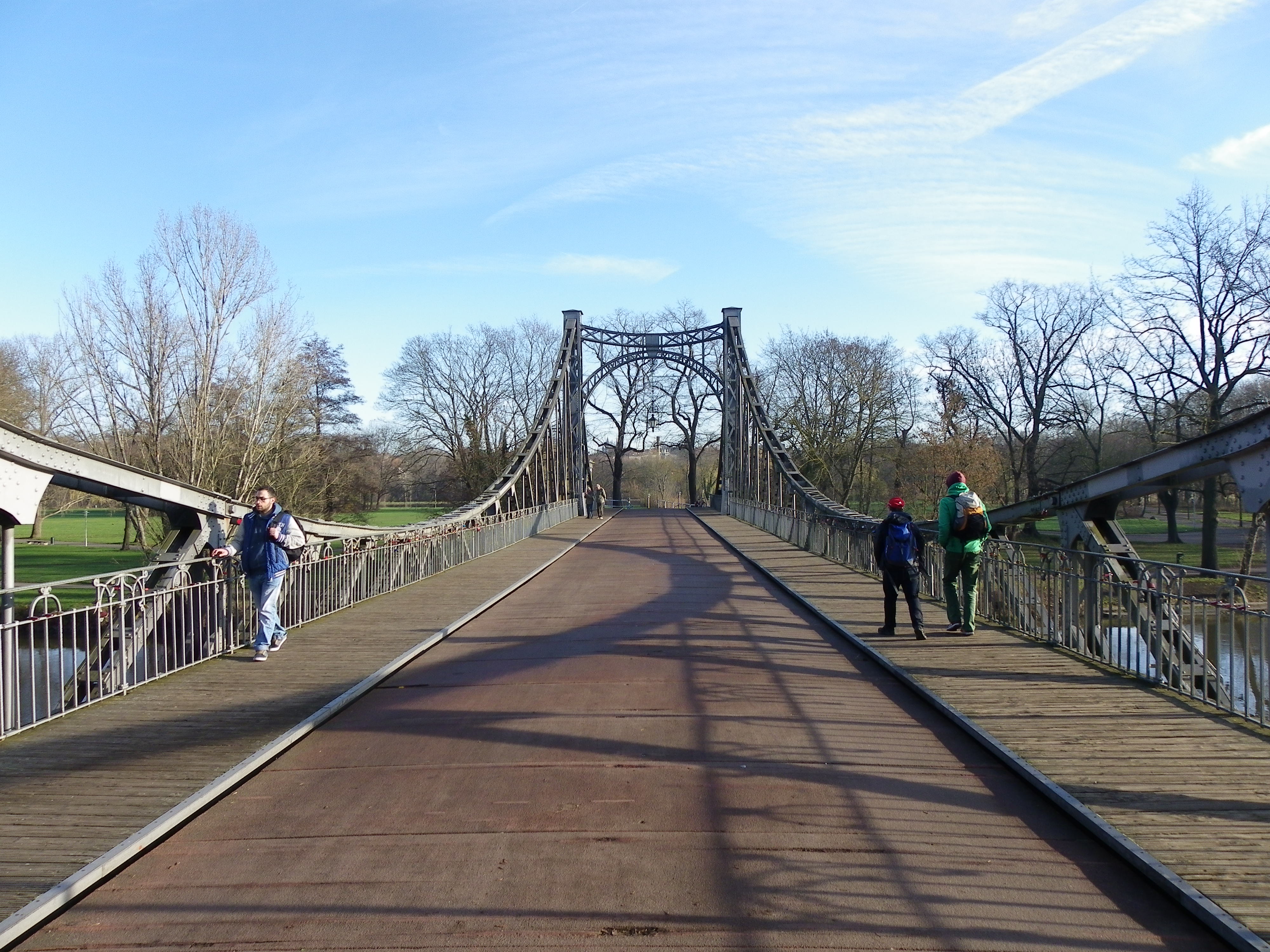
Located at Weinberg at the northwest end of Peissnitz Island, this 1893 bridge is one of the oldest standing in Halle. The structure features a wire suspension span with eyebar connections found at the steel towers. Its roadway features a Town Lattice truss design railing which together with the suspenders, support the wooden decking. The bridge was destroyed during World War II but was later rebuilt in 1946. It was renovated in 1992, which includes dismantling, sandblasting and improving the steel parts, and reerecting the span on new abutments made of brick and concrete. The abutments feature the name Schwanenbrücke on there. The bridge is open to cyclists and pedestrians wishing to enter the island from the northwest. The bridge is next to the island park railway station, which provides service to places on the island.
Spanning the Mühlgraben at Peissnitzstrasse, this 1912 closed spandrel arch bridge has some unique features making a stop a necessity. Like the Pfälzer Bridge, the railings feature a Howe truss in an Art Deco design, all in concrete. Two pairs of cast iron lanterns, encased in concrete, decorated with gargoyles, can be found on each end of the 20 meter long span, which provides the lone access to Peissnitz Island and park area to the west, let alone the Peissnitz Bridge itself. The bridge was named after a water mill, located nearby that was built in the late 1800s and was made of stone. That mill still exists today.
This bridge and neighboring Giebichenstein Castle on the lime cliffs of the Saale River go together like bread and butter. The three-span concrete arch bridge is the fourth crossing at this site, being built in 1928 replacing a steel Parker through truss bridge, whose predecessors included a pontoon bridge, ferry and a covered bridge. The bridge is 261 meters long, 60 of which consist of the largest arch span. The bridge features two sculptures on the south side facing neighboring Peissnitz Bridge, resembling cattle- making the bridge a real treat to see. The bridge was renovated in 1995 and again in 2011, but continues to serve vehicular and street car traffic connecting the city center with the western suburb of Krollwitz.
Like the Peissnitz Bridge, the Pfälzer Bridge, spanning Mühlgraben-a tributary of the Saale- at Neuwerk in the northern end of the city, is the most ornamental bridge but in the form of an arch bridge. Art Deco art on the bridge’s railing and four lamp posts can be seen when crossing the 1912 span by car or bike. The railings resemble a Howe truss made of concrete, a rarity one can see these days.
Located at the Robert Franz Ring, this Mühlengraben crossing is one of the newest bridges along this route. Little has been written about this bridge except for the fact that the steel deck arch span appears to date back to a time span between the 1990s, going back to the 1940s. In either case, the bridge’s lean appearance is attractive for many bridge photographers who enjoy a few minutes with the camera.
When leaving Halle (Saale) by train heading north, this bridge will be the last landmark to be seen on your way out. Today’s bridge, built in 2005, features a cable-stayed span that is 71 meters tall and 171 meters long, spanning the railroad tracks. Yet the bridge came at the cost of a steel eyebar suspension bridge with pony truss decking, which was built during the first World War, with the help of French soldiers. It was originally named the Hindenburg Bridge before it was changed after World War II. Despite being considered a historic landmark, excessive rust and corrosion, caused by diesel-powered trains passing underneath it, doomed the bridge, causing the city council to decide for a replacement span. The cable-stayed bridge was built to the north of the bridge and after its completion in 2005, the 1916 bridge was dismantled and sold for scrap, despite protests by many who wanted to keep the structure for reuse as a pedestrian bridge.
While some local newspapers have mentioned a bit about Halle’s bridges, more publicity on the structures was presented through a guide of Halle’s infrastructure, which was presented last year and included as many as 38 bridges in and around the city. Whether the article originally published in the Chronicles in 2012 as well as following newspaper articles had something to do with that or if people enjoy visiting the city’s bridges remains clear. But given the interest of tying the city’s bridges in with its history, it is a foregone conclusion that these historical structures will be properly cared for for generations to come, thus giving Halle several accolades for its heritage that had been kept under the rug by the East German government until 1989 but has shown its beautiful sides since then. And these 38 bridges, seen here in this guide (in German), together with a map of the bridges visited in 2011 and 2015, are one of many reasons why Halle is a place to visit when travelling through Germany and wanting a good bike tour through the city’s history and heritage. It is one of the cities I’ve since had on my top 10 German places to visit list. You’ll understand why when you get a chance to see it too. 🙂
Peissnitz Island Bridge Photo taken in Dec. 2015
Halle (Saale) is famous for many markets and events honoring Handel and other music greats. This includes the Christmas market, which you can click here to read about. Courtesy of sister column The Flensburg Files.
With one exception, all the photos were taken by the author in 2011, 2012, 2015 and 2017.
This is a blog about my project of visiting every bridge over the Genesee River and what I learned about the history, structure, and natural surroundings of each bridge.