Bettendorf Twin Suspension Bridges spanning the Mississippi River in the Quad Cities. Specifically, between Moline and Bettendorf. Photo taken in Dec. 2014
Eastbound Suspension Bridge brought down by explosives on Sunday.
QUAD CITIES: It took three booms and then the towers and cables tumbled into the Mississippi River. Crews brought down the Eastbound portion of the Bettendorf Suspension Bridges on Sunday morning through a series of controlled explosions. It lasted only a few seconds. That span was the older of the twin suspension bridges that used to carry I-74 between Iowa and Illinois. Designed by Ralph Modjeski, the bridge was opened in 1935 as a toll bridge. The Iowa bound bridge was added in 1960, using the exact design as its 25-year old sister. Tolls were removed in 1970 before it was part of the I-74 highway five years later. It was in service until it was replaced by twin basket-weave tied arch spans on December 1, 2021. Since that time, crews have been working to demolish the twin spans, doing it in reverse order of how they were built- meaning removing the decking, the trusses, the girders and the suspenders. Thousands of residents lined up along the river to say good-bye to the old half of the bridge on Sunday as it came crashing down.
This was what the 1935 Illinois-bound bridge (left) looked like prior to being imploded on Sunday. This was the compilation of film series taken from multiple angels showing the span’s demise:
The Mississippi River is still closed to barges and ships to allow for the clean-up to continue. It should reopen towards the end of the week.
Crews are presently working on the Iowa-bound span with plans to implode that structure at a later date. The Chronicles will keep you posted on the latest. The demolition is expected to wrap up by 2024. At the present time, it is unlikely that any of the bridge parts will be salvaged to be displayed at a museum or memorial.
Continuing on in our series dedicated to the late David Backin, we go to Audubon County, in western Iowa, where this bridge and the state’s signature bluffs go together like bread and butter. It’s one of my stereotypes of the state, speaking from personal experiences growing up there. You see very steep hills where you’re driving like you are on a roller coaster- such as the Legend at Arnold’s Park in Okoboji– and somewhere at the bottom you see a bridge like this one here.
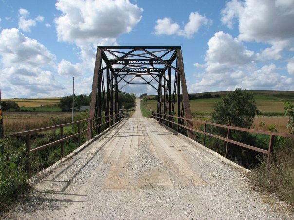
The bridge spans Nishnabotna River at 250th Street just a mile west of US Hwy. 71, two miles south of Hamlin and three north of Exira. The structure was built in 1958 by the Iowa State Highway Commission and features a pair of Pratt truss spans- a 5-panel through truss with A-frame portals and the other, a pony. Both have riveted connections. The bridge has a total length of 162 feet, of which the through truss span has a length of 90 feet. The width is 15.7 feet and the vertical clearance is 11 feet.
Unique about this bridge is its approximate location near a former golf course. At one time, the Greenbrier Country Club was located near the bridge. The nine-hole golf course was built in 1962 and this bridge may have been part of the course at one time. It is unknown how many years the golf course was in business but judging by the satellite view on many maps, it probably went out of business between five and ten years ago, as the golf course is now nothing more than farmland; the clubhouse appears to be privately owned. Golfing was a popular sports attraction in the USA, even in its hey day of the 1980s and 1990s. However, given many circumstances, such as high costs, competition, maintenance of the greens and vegetation and climate change, golf is on the decline, as we’ve seen a 10% decrease in the number of golf courses in the US in the past 20 years. With Greenbrier’s demise, much of it had to do with the competition by the Audubon Golf and Country Club, located six miles up the highway. The nine-hole golf course has hosted many local and regional golf events and since 2016, has a new club house.
Mr. Backlin has traveled through Iowa many times, as US 71 travels straight through the state, but this bridge he photographed in 2009. The structure is still standing today and serves local traffic.
Our next Mystery Bridge has a familiar ring to one discovered last year: The best ones are the ones that are in your own backyard. Satolli Glassmeyer would’ve loved to do a film documentary on this structure for his website, History in Your Own Backyard, had he grown up in the same area I grew up…..
Consisting of Big Spirit Lake, East and West Lake Okoboji, Upper and Lower Gar, Minnewashta and in Minnesota, Loon and Pearl Lakes, the Lakes Region has provided visitors with a variety of activities for everyone to choose from for over 150 years, including golfing, fishing, swimming, boating, enjoying the rides of Arnold’s Park Amusement Park, visiting and/or meeting friends, grilling with relatives, skimming rocks, and the like. Over the years I’ve come to appreciate the history of the region and its natural habitats, but I was also amazed at some of the little-known bridges that existed there dozens of years ago, but would have been listed on the National Register had they remained standing.
This unique bridge is one of them.
John Smeltzer brought this to my attention in one of the posts in the Spirit Lake group page recently and it was one that existed before my time (I was born in 1977). It’s located at the northernmost end of Big Spirit Lake, just south of the Iowa/Minnesota border, at Mini-Wakan State Park. A map with the exact location is in the link below:
According to the information in a newspaper article, the structure was built in 1935, as part of the project to create Mini-Wakan State Park. The information is as follows:
Improvement in this area consisted of the building of a bridge at the west end of the area. 125 barrels. of cement were used, 75 cubic yards of concrete completing a span of 40 feet long and 4 1/2 feet wide. About 1 mile of trails were blazed, graded and graveled. Several thousand shrubs were planted, 3000 square yards of rip-rapping along the new road leading into the area.
A stone shelter with 2400 square feet of floor space and consisting of 110 cubic yards of concrete, 14,116board feet of lumber and 1600 brick.Two latrines of approved sanitary type were built as well as a general cleaning up of the area in preparation for picnicing and accomodation of summer visitors.
The bridge itself featured a Howe pony truss design, and judging by the photo, it was a lumber structure. Howe trusses were rare to find, let alone build during this time because of structural flaws which contributed to bridge failures, with engineers using the Ashtabula Railroad Bridge Disaster of 1876 as its reference, thus the need for sturdier truss bridges, such as the Pratt, Warren, Baltimore and Pennsylvania designs, made of steel and with riveted connections.
The structure connected the east and west peninsulas at the site of the present-day McClellan and Flemming Lanes respectively. Yet little do we know is who was behind the construction of this unique truss structure? We know it was a wayward bridge builder willing to buck the trend and design something with his/her signature on it. We also know that Mini-Wakan was constructed as part of the Works Progress Administration, initiated by US President Franklin D. Roosevelt, whose goal was to reconstruct the American landscape and encourage as many Americans as possible to work on projects that focused on erosion control, nature and architecture. Tens of thousands of buildings, parks and other recreational areas were built under the WPA program until 1941, when the US entered World War II.
We don’t know how long the bridge lasted but the structure was removed before 1977 and there has been no crossing there ever since. Why there is we don’t know, but the abutments of the bridge still remain at each tip, though they can be seen during low water levels, according to John Smeltzer.
The U-Shaped Fishing Bridge. The Howe Lattice Wooden Truss Bridge that connected the peninsula is behind this structure in the southern direction towards the center.
.
The bridge was located only 500 feet from the current crossing at the state border. That bridge was built for cars in the 1930s, but was destroyed in the Great Flood of 1993 and was subsequentially replaced with the current bridge in 1994. Both were built using a concrete beam design and the present structure has a length of 50 feet. When the new bridge was built, the berm and roadway were widened to accommodate the flow of traffic and make it safe for people to cross the road. An additional U-shaped bridge was constructed at the site of the current crossing to encourage people to fish from that area instead of alongside the road. That area still remains popular for that activity, and for bird watchers, one can enjoy the sea gulls and comorants lining up along the bridge’s railings.
.
To sum up, we are looking for information as to the following questions:
Who was the designer and/or builder of the truss bridge that once connected the peninsulas at Mini-Wakan?
When was the bridge taken down and why?
Will there ever be such a crossing to connect the two tips after an absence of almost a half century?
.
Feel free to comment in the section below or send me a mail using the contact details available by clicking on the link here.
.
Your bridge matters! Happy bridgehunting, folks. 🙂 ❤
.
Special thanks to John Smeltzer for allowing me to use the pics and providing some information to start with. 🙂
WEST BRANCH, IOWA (USA)- Located SW of Iowa City, the town of West Branch has a unique historic bridge available for you to purchase. This bridge is located over West Branch Wapsinonoc Creek, on the outskirts of West Branch, east of Beranek Park. The bridge features a Warren pony truss bridge but designed in an unusual way. It features A-shaped paneling, each one flanked with a vertical beam. The number of A-framed panels in total are three with two schmal outer panels near the end posts. Bridgehunter.com has classified it as a Warren pony truss with alternating columns, yet one could classify this one as A-framed Warren trusses with alternating verticles to make it more specific. The trusses have outriggers and the connections are partially welded and partially riveted.
There is no information on the bridge’s history, let alone the builder, but given its unique design, it’s definitely ripe for nomination to the National Register. Because of the introduction of riveted connections, the guess on this bridge is that it was built between 1885 and 1905, as the bridge represented an early example of riveted trusses that were being ushered in to replaced those with pinned connections. As far as its dimensions are concerned, Jim Stewart came up with some rough estimates based on his visit, which includes a length of 41 feet. The width of the bridge is approximately 16.5 feet and the height of the trusses themselves is seven feet.
If you have any information on the bridge, feel free to comment either here or on bridgehunter.com.
Kim Gaskill, who owns property at the bridge, has listed this bridge for sale on facebook Marketplace recently. At a cost of $7000, one can purchase and relocate the bridge to be used for recreational purposes. If you are interested in purchasing the bridge or want to collaborate on saving it, please click here and you will be directed to the page where the bridge is for sale, with additional photos and contact information to Ms. Gaskill.
.
All photos courtesy of Dave King, who visited the bridge in 2013.
Construction is expected to begin in November. Historic Bridge will be relocated to a natural preserve
BERTRAM/ CEDAR RAPIDS, IOWA- The oldest existing historic bridge in Linn County is scheduled to be replaced this fall. However, the historic bridge will have a new life as a pedestrian crossing. The Bertram Bridge features a hybrid Whipple and Pratt through truss bridge with pinned connections. The truss design is similar to a rarely-used Hammond truss. The bridge was generally built using wrought iron. The portal bracings are Town Lattice which extends to its heal braces. These bracings are ornamental and typical of the portals used for bridges built by the Wrought Iron Bridge Company of Canton, Ohio. WIBCo built this bridge in 1876 and it can be found on Bertram Road spanning Indian Creek at Mischka Press. The 191-foot long bridge is eligible for the National Register.
The 145-year old bridge and its blue-colored bridge has reached the end of its structural life as a vehicular crossing and therefore will be replaced. According to officials at Linn County, construction on the bridge will begin this fall- most likely in November. Peterson Contractors of Reinbeck, Iowa won the contract in December of 2021 at a cost of $2.4 million. The project consists of replacing the bridge with a concrete structure that has two lanes, accommodating the increasing traffic. The road will be closed to all traffic during the time of construction. The truss bridge itself will be dismantled and reassembled as a pedestrian bridge at Indian Creek Nature Center on Otis Road. When the reassembly will be completed and the historic bridge will be reopened remains open, but the project is expected to take up to six months to complete.
You can follow up on the bridge replacement project by clicking on this website. You can sign up to follow the project closely.
The bridge is part of a tour guide done a few years ago. Click here to have a look. A map is enclosed there to help you.
This week’s Pic of the Week provides us with a rare example of a historic bridge that is homemade- built by bridge companies that are local with a local engineer overseeing the design and construction. This bridge is located in Linn County, spanning the Iowa River. The Greencastle Avenue Bridge is located NW of Cedar Rapids in the Hawkeye Wildlife Area. It features a pin-connected Pratt pony truss span and a riveted Pratt through truss span with A-frame portals. Originally built as a three-span bridge in 1922, one of the spans was destroyed in the flooding in 1949 and was replaced with a temporary span in 1950. That span was then removed and filled in, reducing the crossing to only two spans. The bridge has been abandoned since 1992 though one can access the bridge by car from the north side but going down a steep hill. At the entrance to the bridge on the north side, it is all for pedestrians.
The bridge is unique as it was built and rebuilt by four different bridge builders, all of which were located in Iowa. Two of them came from the same county as where this bridge is located- Linn County. The pony truss span was built by the Iowa Bridge Company of Des Moines; the through truss span was a standardized bridge built by the Iowa State Highway Commission of Ames. For the reconstruction of the bridge after the flood of 1949, there were two local bridge engineers responsible: Ned L. Ashton of Iowa City and A.P. Munson of Marion. Ashton was well known for bridges during his time, for each of the Cedar River crossings in Cedar Rapids and Iowa City that exist today were either built by him or whose predecessor spans had been built by him but were replaced in the end. The crossing is the second one in its present location as a previous structure, a through truss span, was built by another Iowa bridge firm, J.E. Jayne and Sons, located in Iowa City. That bridge, known by locals as the Dupont Mill Bridge, was built in 1908 and replaced in 1922. All in all, there were five different bridge builders all in this location, three of which in Linn County! Amazing how such a bridge could have the markings left by locals.
The bridge is not on the National Register but should because of its history, including what was mentioned already. The structure is still in place but is in need of a full restoration in order for it to continue its life as a pedestrian crossing. Given its location and setting, it would be perfect except to say, one could make a picnic area out of it, with info boards on its history and that of the adjacent Dupont Mill. Whether it will happen depends on the interest and there seems to be a lot of interest in keeping the bridge and reusing it. The question is whether Iowa Department of Natural Resources and Linn County would agree. But given the county’s high number of historic bridges and the way they have been maintained, there is a chance that the officials will listen and make the proper maintenance of and repairs to ensure the bridge will continue its use for years to come.
Iowa is celebrating 175 years this year and if there is a piece of history that should be considered, it’s this bridge. While the state has seen the likes of King, Jensen, Thacher, Wickes, and Jayne in several of the bridges, there are some that deserve recognition for their work, like Ashton and Munson. And this bridge represents such a structural work that deserves attention from these people.
The next bridge in the Mystery Bridge series is the second of two installments of the bridges in Jackson County, in eastern Iowa. Yet one can look at it as two bridges, because each one has the same problem: looking for the bridge builder. And judging by the identical length these structures have, it may appear that they came from a multiple span structure that had been cut up into spans before shipping them.
After looking at the now extant Caven Bridge, we have this bridge at Iron Bridge Road. It spans the Maquoketa River on the road bearing the bridge’s name, approximately 8-10 miles NW of Spragueville. It’s at the junction of Miller Access Road. The bridge is a Pennsylvania through truss bridge with riveted connections, I-beams and M-frame portal bracings. It has a total length of 420 feet but the truss bridge’s length is 250 feet, thus making it the longest single-span Pennsylvania through truss bridge built in the state. It’s even longer than the Traer Street Bridge in Greene (in Butler County), which was replaced in 1981 after 79 years in service.
According to records in bridgehunter.com, the bridge was built by the Iowa State Highway Commission, which today is the Iowa Department of Transportation. It was established in 1904 and was one of the first highway institutions to have made firsts in the field of transportation, which included traffic signs, like the No Passing Zone sign, as well as paved highways made of tar and later concrete, and finally bridge designs. Yet despite the claims that the State Highway Commission was responsible for building the bridge, it can only be credited for making the design of the standardized truss bridges, which were introduced from 1910 on. What is missing is having the bridge builder who is in charge of constructing the bridge as well as the company that fabricated and transported the steel from the steel mills. It is a foregone conclusion that a highway agency would not have a bridge building firm with steel mills on their lots unless the agency had vast amounts of land to build the steel mills. That would have taken up half of Ames, where the highway agency is still located today.
This leads us to this question: If the highway designed the truss bridge, like the one on Iron Road, where did the steel come from, and who oversaw the construction of the bridge?
These are the two key questions not only for the Iron Bridge here but also its twin bridge, the Damon Bridge, spanning the same river but on 435th Avenue (County Hwy. Z 34), six miles north of Preston. The bridge has the exact same form as the Iron Bridge but was built six years later, in 1956. If you have any information on the two bridges and their predecessors, feel free to comment in the Chronicles directly online, but also in bridgehunter.com under their respective pages.
Your bridge matters! Best of luck in the research. 🙂
The next two mystery bridges will take us to Jackson County, Iowa, located in the far eastern portion of the state. There are two bridges that fellow pontist Troy Knox of Bridging the Driftless brought to the audience’s attention via his personal blog.
This is the first of them. The Caven Bridge was a single span Pratt through truss bridge that spanned the North Fork Maquoketa River on 60th Avenue north of Canton and Emeline. The bridge had a total length of 160 feet, 110 of which consisted of the truss span. Its portal bracing is A-frame but condensed vertically. Nothing is known about the date except sources had it down for 1900. Whether it was built in that year or a couple years earlier or later remain open. There is no information about the bridge builder, except bridges like this one, judging by its portals, may have been built by the Clinton Bridge and Iron Works Company. Yet there is no information as far as builder’s plaques or any inscriptions in the metal beams.
Portal bracing and tunnel view
.
The reason why the information is in past tense is because the Caven Bridge no longer exists. According to information, crews tore down the bridge in November 2021, even though the bridge had been closed to traffic for some time. It is unlikely a replacement span will be built soon as the road is rarely used and the area is sparsely populated. Nevertheless, it would be a great closure to determine when exactly was the bridge built and by whom.
This is where you come in. Feel free to find and comment about this structure. After all your bridge matters. Thank you for your help and best of luck! 🙂
I was digging out some photos that the new owners of Niland’s Cafe in Colo, Iowa needed as they were preparing to reopen the restaurant and business after a three months absence when I came across this photo, taken in 2013. The photo was shot just after we were finished with the Historic Bridge Weekend in Iowa and we decided to get a few shots of the bridges in and around Des Moines before visiting family in Minnesota. It’s a well-known bridge but its design makes it a very attractive place to visit, even at night when the LEDs are lit. I just had to make some changes to make it what it is here.
It’s the Madrid Railroad Viaduct. The bridge was built in 2010 using the piers of a previous railroad viaduct that used to be a deck plate girder made of steel and was used by the Milwaukee Railroad before it went bankrupt in 1980. Chicago and Northwestern then used the line until it was abandoned in 2002 and the bridge spans were removed. The line was then converted into a rails-to-trails and a new bridge with this unique desgn was put into place. You can see more photos and information on the structure by clicking here.
The bridge spans the Des Moines River between Madrid and Woodward, NW of Des Moines. If you are travelling through the area, I would recommend this stop for some photos and a break as there is a picnic area nearby. If there was ever a book on the Bridges of the Des Moines River in the future, this bridge would be in it, perhaps as a cover page. But it’s up to the author to decide. 🙂
TAMA, IOWA- Created in 1913, the Lincoln Highway is the first trans-continental highway that went from coast to coast. Starting in San Francisco at Lincoln Park, the highway runs for 3,389 miles (5,454 km) through 14 US states before terminating at Times Square in New York City. Much of the route has been marked as US Highway 30 and there are many stops along the way where people can enjoy local dining, do a lot of fun activites and lodge in some of the hotels, all of which have been a fixture along the highway, some for as long as the highway has existed. There are many major crossing and historic bridges one can see along the Lincoln Highway.
Among them is this one, located in Tama in central Iowa. The Lincoln Highway Bridge is located at Roadside Park, spanning Mud Creek. Until it was bypassed by the expressway version of US Hwy. 30 in 2012, this bridge was one of the first sites to see when entering the community of 2800 inhabitants. And its one that is worth a stop. The bridge is a concrete stringer bridge but decorated with ornamental globe lighting and a railing bearing the name Lincoln Highway. The bridge was built in 1915 by local bridge builder, Paul Kingsley of Strawberry Point, Iowa. According to HAER records, the idea of the highway bridge with ornamental railings had a special meaning to it:
“In September 1912, the Midwestern visionary Carl Fisher proposed to group of automotive businessmen a plan to build a road spanning from coast to coast. The route, later named the Lincoln Highway, would start in New York City, finish in San Francisco, an cross 358 miles through the state of Iowa on the way. This monumental undertaking was to be privately funded with the towns and counties profiting from its passage sharing a large part of the construction costs. Thus, a widespread advertisement campaign for the transcontinental highway was launched with each community along its path trying to outdo the next in making itself the most desirable rest stop. The town of Tama distinguished itself from the rest by constructing a special bridge for the route with the words “Lincoln Highway” spelled out in the concrete railing. This bridge remains a most unusual maker for this historic highway.”
-Juliet Landler, HAER, 1995
Listed on the National Register since 1978, this unique bridge of 24 feet long and 22 feet wide is the only known historic bridge in the United States that has lettered railings and one of only a dozen or so in the world whose bridge section feature letterings. Another known bridge that has a similar lettering can be found in Duisburg, Germany at the Bridge of Solidarity, built in 1950 replacing a bridge destroyed in World War II. It was one bridge I stopped at during my visit to Tama in 2010 and given its approximate location to the park, it’s definitely a rest stop worth using for some photo opportunities and a good picnic. The bridge is home of the annual Lincoln Highway Bridge Festival, which is held in the summer and draws in thousands of visitors from all over the US and Europe.
Despite this, this unique historic bridge is in danger of becoming history, or at least being altered to a point of no recognition. Cracks have been revealed in the bridge span and parts of the railing, much of it has to do with wear and tear over the year. Even as the bridge has become part of the city and local traffic has been using it since the highway was bypassed in 2012, the bridge is still a big tourist attraction. But the future of the bridge is in the hands of the city council, which according to many news stories, is more or less divided.
One party would like to rehabilitate the bridge and make the necessary repairs to the structure to ensure that it continues to function for the next half century. While the city council had put aside funding for bridge repairs of up to $150,000 and the rest of the funding would be covered through a series of donations and support from the Iowa DOT, when presenting the bids for rehabbing the bridge by the engineering firm of Schuck-Britson from Des Moines in October 2021, the lowest bids was double the amount. Still, an in-kind restoration of the bridge would allow the bridge to continue to function as a crossing and as a tourist attraction.
Railings of the Bradford Street Arch Bridge in Marble Rock, Iowa when it was replaced in 1995. This is located at Marble Rock Park. Photo taken in 1999.
.
By the same token, there have been growing calls from members from another party, which favors moving the historic bridge, or at least the lettered railings and lamp posts to the adjacent park and install a 15-foot culvert over the river. Their argument was that it was less expensive, easy to maintain and easy to replace even if it had a 15-year lifespan. The downside to this plan is that it would alter the bridge to the point of no recognition and it would lose the tourist appeal, let alone its status on the National Register. This was the case with the Marble Rock Arch Bridge in Floyd County. The three-span concrete arch bridge, built in 1914, was replaced in 1995, but its railings were relocated to a nearby park- out of site and out of mind. 😦
The Tama City Council was supposed to make a decision on the bridge’s future, based on the information they collected, on March 21, 2022. At the present time, no decision has been made. There is a consensus that the bridge should be restored to its original form, but the paperwork and instructions needed for the project is lacking (see article here for details). That plus the increase in costs for restoring the bridge might doom the project altogether. This bridge is the last of the structures along Lincoln Highway in Tama County, after losing a similar icon over Otter Creek at Chelsea in 2006.
Still, to this day, despite the highway being bypassed, the Lincoln Highway Bridge remains a popular tourist attraction and one where its original purpose was to serve as a rest stop for travelers going along this important highway. There is hope that this purpose stays that way- not as a piece of relict being put on display but one that still has this function as a crossing over Mud Creek. If this stays, Tama will continue to have a tourist attraction many people- bridge-lovers, tourists and all people alike- will stop by to see, and enjoy the scenery. ❤ 🙂
This is a blog about my project of visiting every bridge over the Genesee River and what I learned about the history, structure, and natural surroundings of each bridge.