Our next Postcard Friday feature takes us from Thuringia to the metropolitan area of Frankfurt/Main in the German state of Hesse. Featuring Frankfurt itself, plus the cities of Wiesbaden-Mainz, Aschaffenburg, Offenbach, Darmstadt and Frankfurt Airport, the metro area has a total population of over 6 million residents, and covers sections of Hesse, Rhineland-Palatinate, Bavaria and Baden-Wurttemberg. It has a well-structured but also dense metro-network of railroad and bus, and has two rivers that meet: the Main and the Rhine. Both rivers and their tributaries are laden with bridges. And while 30% are more than 70 years old, the remaining 70% have been modernized, replacing bridges built during the age of Industrialization (1830- 1920), half of which were imploded by the Nazis in early 1945 in an attempt to slow down the incoming American troops. Recognizing that this attempt was an epic failure, Nazi Germany capitulated on May 4th in Hamburg and accepted terms of an unconditional surrender at Rheims, France on May 7th, yet the last pocket of Nazis in exile were arrested by British troops in Flensburg on May 23rd.
The bridge featured in this week’s Postcard Pic is one of the casualties of World War II. This is located in Offenbach over the Rhine River near the Harbor. It’s the Carl Ulbricht Bridge, named after the man who was president of the People’s State of Hesse from 1919-1928. It’s the only bridge in Offenbach, yet it provides direct access to the train station located to the north of the city in the suburb of Fechenheim. The bridge is located next to Isenburg Castle.
The postcard featured here is the structure that was built in 1887. It had seven steel arch spans using a Pratt truss design. It had ornamental lighting and ornamental railings, even though one can barely see it in the postcard. Given the river’s width plus the number of arches, the bridge was probably over 230 meters long, which would be the same length as the bridge today. Because of its narrowness, the bridge was widened in 1933-34, yet its functional life was shortlived as the Nazi troops blew up parts of the bridge in the Spring of 1945 in an attempt to hinder the American troops who were marching into Germany on the western and southern ends. After the war was over, the sections were rebuilt and the bridge was reopened in 1947, yet plans were in the making to build a newer structure on an upstream alignment. The new span opened in 1952 and served traffic until its replacement in 2014. Today’s bridge is the sixth one in place, but is still the only Main River crossing going into and out of Offenbach. The bridge also holds the title of being the only Main River crossing that was rebuilt on different new alignments multiple times, if we subtract the reconstruction of 1933-34 and 1947. The first bridge was built in 1819 and lasted almost 70 years until the bridge in this postcard was built.
Given the fact that many of America’s newest bridges are being built on new alignment to give the structure being replaced borrowed time before being demolished, it makes a person wonder if these structures were to deteriorate within 50 years, if they would follow the Offenbach Model and build a new bridge on another new alignment at the expense of nearby houses or habitats, or if they would be demolished on site and hinder traffic, the lifeline of some nearby businesses. Some food for thought as we approach the weekend.
Picking up where I left off in the Dresden series last Friday with the works of Gustav Frölich, we look at another bridge that was found on several postcards. Yet this bridge no longer exists as it was a victim of World War II.
The bridge we are presenting here is the Carola Bridge (D: Carolabrücke), spanning the River Elbe just west of the Albertbrücke. It’s adjacent to the Church of our Lady in the historic City Center and carries Hwy. B170, connecting it between Albertsplatz and Georgplatz. Today’s structure is a typical concrete beam bridge that stemmed from the Communist era, as you can see in a photo taken by daughter during a trip to the capital, recently:
Today’s structure was constructed in 1971 and has been undergoing extensive renovations since 2019. But wouldn’t a person imagine a replacement structure that would bring back the golden days of Dresden, something that goes along the line of this:
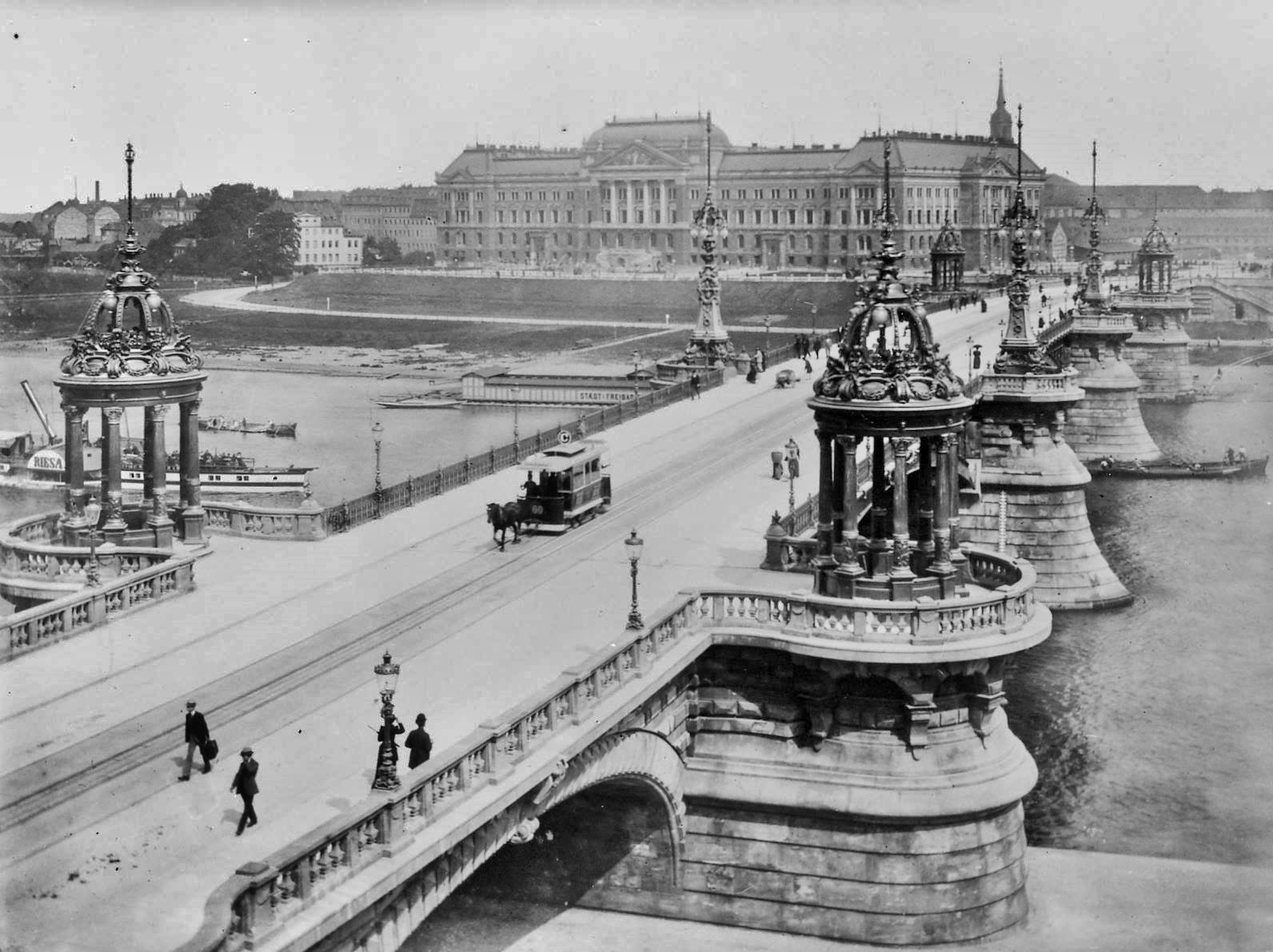
The Carola Bridge in 1895 shortly after its opening. Source: Hermann Klette, Dresden, Public domain, via Wikimedia Commons
The idea of the Carola Bridge came from a local architect, Karl Manck (1835- 1888). Like Fröhlich, Manck had already left his mark in architecture and infrastructural engineering in his hometown of Dresden, having built several buildings and bridges that had ornamental features. He was the city’s engineer and was in charge of the expansion and modernization of the canal and sewer systems in Dresden, leading the way for systems like that to be developed in Saxony, Germany and the rest of Europe. He had designed two bridges, the Albertbrücke, which he oversaw the three-year construction of the stone arch bridge, having opened in 1877. Then there was this bridge, the Carola Bridge, which he had designed the structure but never carried it out, for he died suddenly on 15 November, 1888 at the age of 50. His successor, Hermann Klette (1847- 1909), picked up on the bridge project Manck had left off, and construction of the bridge began in 1892. In 1895 the bridge opened to traffic and was named after Carola von Wasa-Holstein-Gottorp (1833–1907), who was King Albert’s wife and was the last queen of the Kingdom of Saxony. With the exception of the Communist time between 1971 and 1991 when it was named the Dr. Rudolf-Friedrichs-Brücke- the name Carola Bridge has remained on this crossing because of her role in the history of Saxony.
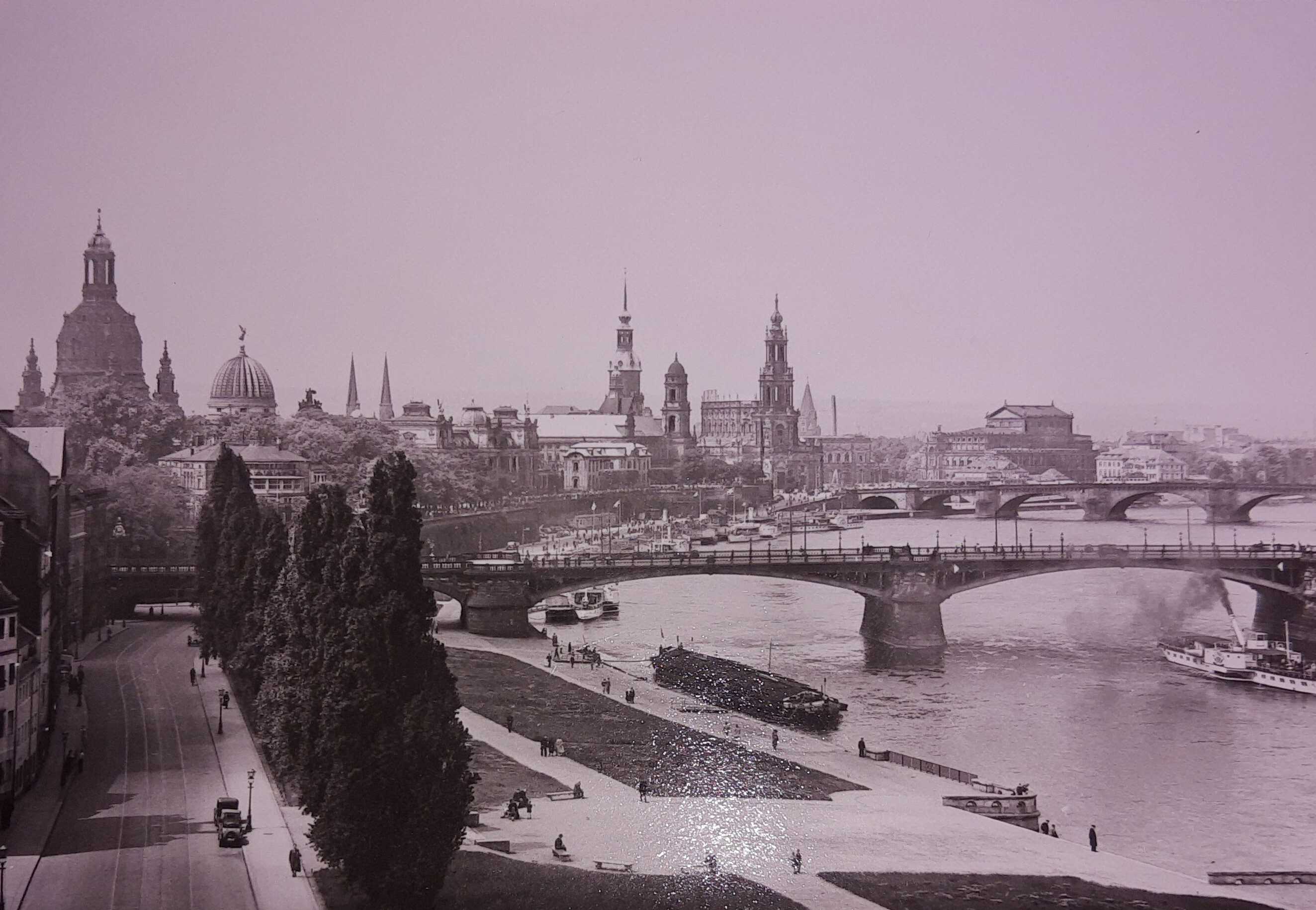
Several postcards showed the 1895 span from different angles and this one gives the reader a better idea what it had looked like. The structure featured three spans of steel deck arch with ornamental steel railings and lattice bracings underneath the decking, as well as stone arch approach spans with parapets on each end of the riverbank. The bridge was decorated with ornamental lamp posts and chapels on each pier, resembling the Baroque design that Dresden stands for to this day. It was considered the most ornamental of Dresden’s bridges and was the focus of several monuments and statues that were found at the entrance to the structure as well as along the shores of the Elbe, like in this postcard below:
Sadly, it was the bridge that became part of the family of the fallen jewels of Dresden in 1945. The structure sustained extensive damage during the infamous bombing raids on February 12-13, 1945, which destroyed the Church of our Lady and much of the architecture of Dresden’s historic Old Town. On the evening of May 7th, six days after Hitler’s suicide and one day before Admiral Karl Dönitz accepted terms of an unconditional surrender to the Allied Troops, Nazi Soldiers imploded the center spans of the Carola Bridge in a futile attempt to stave off the oncoming Soviet troops. To put the last nails in the coffin, the East German government began removing the rest of the bridge beginning in 1952. The middle pier was removed by 1960, clearing way for the present-day structure that was opened in 1971.
Despite its non-existence, the Carola Bridge still remains a popular crossing on its postcards, especially one based on the 1895 design, be it in the olden days before 1990 or in today’s form. Nevertheless when it comes time for the Communist-era bridge of over 50 years old to come down, the question would be what will come in its place? Will we see a remade structure similar to the Church of our Lady? Or will we see the return of the arches but in its modern form but decorated with the ornaments from the past. In any case, as long as the postcards depict the 1895 span, the more we will talk about the bridge in its historic and future form.
Like Manck, Hermann Klette had designed and reconstructed another bridge over the Elbe in Dresden, but had never completed it because of his death in 1909. We will look at that in our next edition of Postcard Friday with the Augustusbrücke, located around the river’s bend near the Palace and Zwinger Opera House.
Co-produced in connection with Germany’s Reunification of 1990, which is October 3.
When we think of Germany and its historic bridges, one of the first structures that come to mind is the Hohernzollern Bridge. Spanning the River Rhine, the three-span steel through arch bridge serves rail traffic and is located approximately 500 meters from the central station of Cologne. Another 200 meters away and one will find him/herself at the world-famous Cologne Cathedral (D: Kölner Dom). The bridge is a popular place for love locks, which can be found along the railings on pedestrian portion of the bridge. For photographers, the bridge makes for perfect photos, especially if it is together with the Cathedral, like this one:
While I was in Cologne in February 2010, I took a couple hours to photograph the bridge, even though a major storm with powerful winds swept through Germany forcing the shutdown of train services. I eventually had to stay overnight in Frankfurt (Main) after having been stranded for hours along the ICE-Train line going home to Thuringia. The two-hour delay in Cologne was in connection with a connecting train to Frankfurt having been cancelled. Despite the wind and rain, I took the chance and got a few photos of the bridge at angles that were suitable for shots.
While I was photographing the bridge I also got some with the statues located at the portals, like this one taken from Cologne Station:
It took four years to construct the bridge, which opened in 1911. Rudolph Schmidt oversaw the planning and design of the 409 meter long structure which has six tracks and a bike/pedestrian path. Fritz Beerman and Friedrich Dircksen oversaw the construction of the bridge with MAN in Gustavsburg providing the steel and the workers. The construction featured not only the steel arch spans and the stone arch approaches, but the statues of the German emperors at each corner of the bridge and this:
This was the postcard of the portal of the Hohenzollern bridge featuring one of the most, well-built portal entrances of the railroad bridges built in Germany, prior to World War II. There were three entrances for rail traffic, two watch towers and a skyway between the towers, per portal entrance! As you can see in the picture, the bridge was a crossing for all to use, for not only the trains used it, but also the trams, horse and buggy and of course, the pedestrians.
The bridge was destroyed on March 6, 1945 by the Nazi Army as they fled the American troops who had already occupied the city center of Cologne. Because of its historic value, sections of the arch spans were saved and those that were destroyed were rebuilt to mimic the original bridge. This was completed in 1958 but unfortunately, it came at the cost of the towers and the portal entrance- they were torn down completely! An additional arch span was added in 1989, thus its present-day appearance. The statues of the emperors and the stone arch approach spans were left in place and restored to its original form.
The bridge today is a popular attraction as thousands of visitors cross the bridge on foot daily, enjoying the scenery, tying the knot through love locks and getting some great photos of the bridge. The bridge serves both long-distance and regional train services with hundreds of trains using the bridge every day. It is a unique structure with a high degree of historic value, putting it in the top three places to visit while in the largest city in western Germany. If you are stranded for a couple hours due to train delays or cancellations, take the time to visit the bridge and the adjacent Cathedral. The two hours will be well worth the visit.
Speaking from experience, the two hours was worth it. Even if the storm was nearby. 😉
.
More information on the Hohenzollern Bridge can be found here:
Bad Bramstedt. It’s one of the oldest known towns in Schleswig-Holstein, with its known existence dating back to the 3rd Century. It’s a health span community that specializes in treating people with arthritis and other forms of rheumatism. Geographically it is in the middle of everythere- in the Moorlands, and in terms of distance between Hamburg, Kiel, Lübeck and Bad Segeberg. It features the statue of Roland, created in 1693 and can be found along the town’s famous Chausee. The Chausee itself was built in 1830-32 and one can follow the cobblestone road for 94 kilometers from Altona (near Hamburg) to Kiel. It crosses another major historic road, the Ox Road, which dates back to the 16th Century and connects Hamburg with Flensburg via Rendsburg.
Bad Bramstedt also has one of the highest number of bridges in Schleswig-Holstein. If counting the one in Schmalfeld, which is four kilometers away, Bad Bramstedt has over two dozen bridges that span the three rivers that form the Bramau: the Hudau, Ostrau and the Schmalfelder Au. The Bramau itself only flows for 12 kilometers before meeting the River Sturgeon (Stör), but that story is for another time as we have a bridge to show you in connection with that.
Of these, we have three of the oldest known arch bridges in the state, which we will showcase to you. The structures were built in the 17th and 18th Centuries and used to serve as key routes for travel and commerce along Ox Road and the Chausee. Thanks to the Motorway 7, which was built in the 1960s and 70s to connect Hamburg with Flensburg, these crossings now serve local traffic, but with a few exceptions, as we will see in the tour guide. Two additional but younger arch bridges in Bad Bramstedt will also be featured in the tour guide. One of them is a red brick arch bridge located at a mill; another was built to alleviate traffic along the Chausee. These five arch bridges are marked with road signs directing them to the sites and with a couple exceptions, also provide some useful information on its history. One caveat we noticed during the tour is that we don’t know who built/oversaw the building of the bridges. If you have any information that is useful, feel free to use the contact info here and send it regardless of language.
Like the city itself, four of the five bridges are located within 300 meters of the Statue of Roland; the other requires a quick four-kilometer trip, which is with easy reach. Here are the bridges you should see:
Schmalfeld Arch Bridge-
Known by locals as the King’s Bridge (D: Königsbrücke), this bridge dates back to 1785, when it was built to replace a wooden structure. Legend has it that one of the lords of the Danish king in 1771 claimed that the bridge was/ should be built made of gold. Whether that is true or not remains to be seen. Another story was a dispute between the lord and King Christian VII over whether it was built of gold or stone, with the latter believing it was a stone bridge. What is true is during that time, Bad Bramstedt, as with all of the duchies of Schleswig and Holstein as well as Hamburg were once part of the Danish kingdom and remained so until after the Danish-Prussian War of 1864. The bridge is a three-span stone arch bridge that was built using granite that was cut into fine cubes and constructed neatly; the stone cubes were then fastened with metal to ensure the bridge remains stable. The structure is 21 meters long and 5.5 meters wide, of which 4.66 meters has the cobblestone roadway. The Schmalfeld Arch Bridge once served a branch of Ox Road which residents of the village took advantage of the trade of commerce provided during the 17th and 18th Centuries. It served traffic until its replacement on a new alignment by a concrete beam bridge in 1983. In 1985-87 it was restored to its former glory. The bridge is a technical monument on the state and national scales. The structure today is a monument with park benches for people to break and enjoy the bridge, its history and lastly, Schmalfeld’s scenery.
Location: Dorfstrasse at the Junction Bramstedter Landstrasse
One of the most photogenic bridges to see while in Bad Bramstedt is this bridge. It’s located directly in the city center. The bridge spans the Osterau and is part of the Altona-Kiel Chausee. It was built in 1830-32 upon order of the Danish King Frederick VI. Like with the Schmalfeld Arch Bridge, the bridge was built using granite blocks and constructed in a similar fashion. The bridge has three arches and has a total length of 16.9 meters long, and a width of 8.75 meters. The first mentioning of a crossing came in 1650, based on a map drawn by Johannes Mejer of Husum (1606- 1674), yet the exact description of the predecessor came in 1731, where an unknown structure with a length of 14.9 meters and 5.4 meters existed at the present-day site.
The bridge and the Chausee were both widened in 1950 to accommodate the increase in traffic passing through Bad Bramstedt. During the widening process, the keystone portion of the arch span was replaced. Since that time, the bridge has been serving traffic in its present condition with no restrictions. Part of the reason why the bridge has maintained its pristine condition has been to the Motorway 7, which has taken much of the traffic away from the city center. Nevertheless, the bridge still receives its fair share of daily local traffic.
Like with Bad Bramstedt, the Beecker Bridge is literally located right in the middle of all the action. To the east, one can take a few seconds to enter Island Park along the Osterau. To the north, there’s the Mary Magdalena Church; to the south is the Statue of Roland, the eateries and all of the city’s public offices. To the west is much of the shopping possibilities Bad Bramstedt offers. For photographing the bridge, the best shots can be found on the western side of the structure- either by the pizzeria or at the Statue of Wiebeke Kruse across from the Church. One can include the statue with the bridge in the background, as you can see in the pictures presented.
Like the Schmalfeld Arch Bridge, the Beecker Bridge was mentioned in several resources, including the two-volume book on Germany’s stone arch bridge, where the information on its construction is mentioned in detail. It is considered a technical and historic site on the state and national levels, especially in connection with the history of the Chausee, which was Bad Bramstedt’s main artery until the Motorway 7 came to town.
Another important structure to visit while in Bad Bramstedt is this one. While one will not notice it at first, but the Friedrichsbrücke is behind the Burger King Restaurant along the Chausee (now named Altonaer Strasse). According to the information board at the bridge, the three-span stone arch bridge over the River Hudau is one of the most preserved bridges of the 19th Century and is one of the most important crossings along the Chausee. The bridge was built at the same time as the Beecker Bridge, having been finished after two years construction in 1832. The bridge was opened to traffic on 1 July, 1832, with Danish King Frederik VI taking part in the ceremonies. The structure is 32 meters long, the width is 5.73 meters. The bridge was built prior to the completion of the Chausee in 1833. Nevertheless, the decking, originally made with large cobblestones, was replaced twice- in 1876 with large and small cobblestones and again in 1926 with small cobblestones. The roadway today still has the cobblestone decking from 1926. The bridge was bypassed with another structure located 100 meters away in 1938 but still serves local traffic to this day. Unfortunately, the structure is due for extensive rehabilitation as the railings have deteriorated and therefore have been fenced off. Plus there is very limited access to the bridge while on foot due to vegetation and the aforementioned issue. Hopefully it will be restored like with the Beecker Bridge in the near future, given the fact that it is also a historical and technical monument.
100 meters away from the Friedrichsbrücke is this bridge, spanning the Hudau and carrying Highway B4. This impressive structure features two arches: the Luten arch crossing the river and a silo-shaped span which goes over a path. While the Beecker Bridge was rehabilitated in 1950, the rehabilitation of the Chausee started 15 years earlier, during the Third Reich. And with that, the date of 1938 should come to mind. It was that year that the Kiel-based firm, Ohla and Lovisa, completed the main span. The approach span came later after World War II. The rehabilitation and expansion of the Chausee started in 1926 with the goal of straightening out the road to accommodate more traffic. Sadly it came at the loss of several buildings, including a restaurant near the city center. World War II also stalled efforts to complete the project, which finally happened in 1953, taking 27 years to complete. This stretch, where the Christianbrücke was built, was finished in 1941, right before the project was halted to shift efforts to defending Germany from incoming Allies marching in from all directions. The bridge is not listed as a historical monument, but should given its uniqueness and its association with the Third Reich and the Expansion of the Chausee.
Location: 100 meters east of Friedrichbrücke at Hamburger Strasse
Our last bridge is the newest of the arch bridges one can find in Bad Bramstedt, and it is one that is widely unknown among historians and pontists. The Mühlenwehr is one of three bridges that spans the Osterau and connects the main land with the island bearing the river’s name. The island and adjacent park complex were once a place where as many as six mills existed along the river. The oldest dated as far back as the 16th Century. Work started in 2001 to transform the area along the Osterau into park with an oasis and an island in the middle of the river, featuring a water fountain, picnic areas, swimming pool, and trees. The idea came as two of the mills remaining had been restored in the 1970s and have since found their new uses. It is possible that the Red Arch Bridge may have been one of the three new bridges built during that time. The project was finished and opened to the public in 2003. It’s located 150 meters from the Beecker Bridge. The Red Arch Bridge is located next to one of the restored mills at Schlüskamp 8, near the bus stop.
When traveling to the Baltic or North Sea, one should take a couple hours to stop here in Bad Bramstedt. The town has a lot to choose from and one could take a couple hours to see the most important places before moving on up North. Aside from the Statue of Roland, the Osterau Island and Park and the city center, there are the bridges, especially those mentioned here in this tour guide. With the one in Schmalfeld, it’s only four kilometers away but reachable. Each bridge has a place in the history book because of their charm and their history in bridge construction. While they were once part of two of the major roads going through Bad Bramstedt and Schleswig-Holstein, these bridges today are part of the state and national heritage, serving as a reminder of bridge engineering and the development of the infrastructure, which served as the foundation and starting point for the expansion and modernization of networks that today take people through Schleswig-Holstein to Denmark and Scandanavia to the north and the rest of Germany and Europe to the south and beyond. This is why Bad Bramstedt is in the middle of everywhere, not just in geographical terms but also in terms of the infrastructure.
.
Unless noted, all photos were taken by the author in July, 2023
.
Note:
I’m collecting informaton and old photographs for a book I’m writing on Schleswig-Holstein’s bridges. If you have any that you would like to share and/or wish to contribute, click here for more information. Contact details are included. Thanks! 🙂
We are pushing up the Post Card Friday to Thursday to allow for some space for the last segment of the Interview series with the winners of the 2022 Bridgehunter Awards.
Our fourth Post Card Friday series is the same as the 199th Mystery Bridge. It takes us to Bad Brambach in the southwestern part of Saxony towards the Czech border, located 20 kilometers east of Asch. This bridge is one of the most unique of covered bridges in the area. It spans a ravine near a spa resort and park. The bridge is built made of wood, but we don’t know how many times it has been built and rebuilt. A pair of post cards shows the bridge in two different time periods. In one time period (see below), the bridge was built using wooden beams. In one time period (above) it was built using Warren trusses with outriggers. The assumption is that the one above is younger than the one below.
In both cases, there is a covered bridge, whose trusses is a cross between a Howe and a Town Lattice. One may compare this with a Bailey, yet that truss was patented during World War II and made using steel. The portals feature peacock style bracings. One has to assume that the bottom picture dates to the late 1800s to early 1900s whereas the top picture came from the first part of the 1900s; the covered bridge span having been built in the era towards the turn of the Century. But these are all assumptions and more research would be needed to find out when was the this bridge built. Specifically:
When was the first bridge built, counting the covered bridge span?
How many times was the bridge rebuilt?
When was the modern bridge built?
Who was behind the design and construction of the covered bridge, counting the rebuild?
The modern variant appears to have been built 10 years ago. A link to the photos of the new structure can be found here.
Any ideas? Feel free to comment below or in the Chronicles’ social media pages.
While we are looking at the flooding events of 1993 and 2008 in the United States that impacted historic bridges, this month of June also marks a somber anniversary. 10 years ago this month, the Great Flood of 2013 occurred in much of Germany. It was the second “century flood” in 11 years. And while the Great Flood of 2002 devastated the eastern half of Germany and Eastern Europe, destroying hundreds of bridges and tens of thousands of homes, putting cities such as Dresden, Magdeburg and Hamburg almost completely underwater, the Great Flood of 2013 was less severe as residents and city governments were much more prepared for such an event, having built dikes and flood control systems, having built bridges that withstand the floodwaters, and in worst cases, having forced residents in low-lying areas to relocate on a permanent basis. However, unlike the Great Flood of 2002, cities in other regions who did not feel the rath of Mother Nature got it head-on with the one in 2013.
Apart from Glauchau, Chemnitz, and Leipzig-Halle, floodwaters also reached Jena, in eastern Thuringia. There, half of the city center of the university community of 130,000 was underwater, together with 70% of the Saale River Valley going south, including the main north-south artery, the Stadtrodaer Strasse (Highway B88), as well as parts of Burgau and Lobeda- both located in the South of Jena.
And this is where this pic comes in, to show how severe the flooding was during that time. This is one of the Alte Burgauer Brücke spanning the River Saale in the suburb of Burgau. The six-span stone arch bridge was built in 1546, was destroyed towards the end of World War II in 1945 and was left as bridge ruins during the East German era. It wasn’t until 1999 when reconstruction started and the bridge was restored in-kind to its original form. The bridge reopened in 2004 with a celebration and since then, only bikes and pedestrians are allowed to use the bridge. A book on the history and restoration of the bridge came out four years later.
For Jena, this was the first major flooding event since 1994, when the same area was completely under water. For me, as I have seen many floods, including the ones from 1993, the Red River of the North floods of 1997 and the one from 2002, this brought back memories, especially seeing places that are under water and watching the massive amounts of water flow downstream but not before taking out homes and businesses in the process. But more painful is the process of rebuilding and finding ways to avoid a repeat in the future. Especially in a densely populated Germany is this a problem because of the amount of red tape a person has to go through in order to have a permit to even rebuild what was lost.
Despite this typical German bureaucracy, one thing remained the same- that people worked together to keep the floodwaters out and also to rebuild. This sense of solidarity is something that is missing in today’s hectic society where every man is for himself, yet it’s part of the concept we all need to learn, regardless of circumstances- common sense. From my perspective it means the following:
Common sense is not just holding the door open for others to pass
It’s not just saying please and thank you
It’s not just wishing someone a nice day, regardless of who you meet.
Common sense is nothing more than empathy-
A process of understanding the person’s problems
A process of helping the person when it’s needed
A process where we treat everyone with respect and decency.
Without empathy we have no solidarity
We have no democracy
We have no system which makes things work
Regardless if it’s a state or a neighbor.
Empathy is everything.
My take on flooding and the sense of empathy, which is badly needed in light of what is happening.
.
Like the Great Flood of 2002, many bridges were damaged or destroyed. The hardest hit areas were the ones along the Zwickau Mulde River, where one in every five bridge was hit. This included the structure south of Glauchau in the village of Wernsdorf, which was built in 1953. After sustaining extensive damage, it was replaced in 2016 with the present-day structure, known by many today as “The Wave.” Information and photos of “The Wave” can be found in Glauchau’s Bridge Tour Guide, which you can click on the link below:
The second of the two Snyder Park Bridges is also a mystery bridge. Yet the question when taking a look at the two is which one is the more glamorous of them? After looking at the unique Stone Arch Bridge in our last Mystery Bridge post, we have this one: The Snyder Memorial Bridge.
Spanning Buck Creek on Snyder Park Road, the Memorial Bridge is a combination of iron and steel bridge that has a little European flavor to it. According to Nathan Holth, the bridge was built in 1897 but it is unknown who had built it. It features an arch span that is half pony and half deck. It also has a Pratt pony truss span whose endposts are vertical and have ornamental castings.
Looking at it from an expatriate’s point of view, these have the features of a typical truss and arch bridge built in Germany. As reference, one needs not to look further than the Levansau Arch Bridge in Kiel in Schleswig-Holstein. Built in 1894, it was one of two bridges built by Hermann Muthesius over the Baltic-North Sea Canal, yet when it was built, it featured a combination through truss with Howe features, plus an arch span that was half pony-half deck. Its portal bracings were more ornate than this one at Snyder Park- as it featured brick arch portals with decorative features. A postcard of the bridge can be found here:
In 1952, the bridge was stripped down to the arches, eliminating the portals and the trusses. The bridge is still serving traffic, but its replacement is just around the corner and the structure is expected to be torn down by 2028.
Going back to the Snyder Memorial Bridge, the design of the bridge is definitely one that is typical of European bridges and like the truss bridges in the States, they too are becoming rare to find. What is known are the bridge railings that are outside the trusses and carry a wooden pedestrian path. These railings have an arched lattice design with vertical posts with decorative castings. According to Mr. Holth, the railings were patented by Chester B. Albree, who had a company based in Pittsburgh, PA. Established in 1893, Albree’s railings were used extensively in western Pennsylvania and were common on many structures throughout the US. Yet it is unknown whether he installed the railings to this bridge when it was built four years later.
As mentioned in the previous post, John and David Snyder created the 217-acre park that featured a combination of forests, ponds and even a golf course in 1895, yet they endowed a bond worth $200,000 to ensure of the park’s upkeep and paid $25,000 for the construction of the bridge. It is unknown who was the bridge builder and whether Mr. Albree constructed the railings for the bridge, the entire structure itself or if he had nothing to do with it.
And this is where you are up. What do we know about the bridge? Feel free to comment in the section below. The same applies to the stone arch bridge that was posted a day ago. Your bridge matters and we look forward to hearing about it.
David Backlin photographed the bridge in 2018 when it was closed to vehicular traffic. Pedestrians and cyclists however can use the bridge.
.
This was the last one in the series dedicated in memory of David Backlin. There will be more to come yet they will be integrated with those posted by the author and other bridgehunters and in its usual time slot of once a week on Mondays. We just want to showcase his work as a way of saying thank you for what you did as a bridge photographer and contributor. You will be missed.
When I first visited Glauchau in 2016, I knew nothing about the town’s heritage, its best kept secrets, the histories behind the town’s historic buildings, churches and even its historic bridges. In fact, when I was in Glauchau for the first time ever, I was there for a job interview at the Saxony International School. I was there with the bicycle and on my way to the site, which was at that time in the western outskirts of the city, the first, well-known bridge I saw was this giant structure. A large arch bridge crossing a valley and a main street, which had been layered with cobblestones at that time. The bridge was tall enough that when on the structure, one could see much of the town and with that, the countryside of western Saxony, which was farmland at that time. A splendid view from the bridge, but a key functional route between the train station and the city center.
Fast forward seven years later, residing directly in Glauchau, we know a lot about the city’s bridges- many discovered during my bike tours, some discovered while hiking with my wife and daughter in the forest behind the Virchow Hospital- all totalling about 16 of them. A tour guide on Glauchau’s bridges you can find here:
But the one bridge that is the focus is the first one I saw and have photographed them multiple times ever since- the Scherberg Bridge. The structure is celebrating its 100th birthday this year. On April 29th, 1923, the bridge opened to traffic and connected the town’s districts of Scherberg and Töpferberg. The bridge is the largest of the three bridges that span multiple valleys enroute to the city center. Because of the high number of churches in the city center and points to the south, the bridge is known as one the The Three Bridges to the Holy Land. But what do we know about the bridge, which is not only the largest in the city and one of the four longest? Here are some facts to know about:
The Scherberg Bridge spans Talstrasse and Carolatal, a valley that starts at Carola Park located near the Glauchau School of Business (D: Berufsakademie Glauchau) and after going through a reservoir north of the park, runs straight down towards the Zwickau Mulde at Lindenstrasse. The bridge can be seen at best near the roundabout where August-Bebel-Strasse, Am Schaffteich and Auerstrasse meet, yet one can also get some shots from the hill at August Bebel Strasse and Talstrasse but also from the north end at Otto-Schimmel-Strasse near the abandoned Palla Factory site.
The bridge is a three-span, closed spandrel, concrete arch bridge. The south approach span features a circle-shaped arch that is implanted in the slope. The north approach has a vertical arch approach built on flat ground. The main arch features a classical, Luten-shaped arch span that is ribbed but in a square shaped format.
Rothbart and Co., located at Unter den Linden in Berlin, was the builder of the Scherberg Bridge. While the cost for building the bridge is unknown, sources had indicated it had cost as much as a loaf of bread during that time thanks to hyperinflation that residents had to endure during that time.
The coat of arms can be found on the eastern side of the bridge between the main arch and the northern arch approach span. It symbolizes the city of Glauchau.
The bridge is over 100 meters long- the main span is 35 meters. The height of the bridge is 13.4 meters high from the street it crosses, Talstrasse.
The bridge was rehabilitated in 2011, the Talstrasse was rebuilt in 2018.
Despite the view of the northern part of the city, the bridge was also a site of tragedy, where two people jumped from the bridge- one in 2006 and the other in 2011. In response to the two cases, a suicide hotline was estabished to help those who think about taking their own lives.
Constructing the Scherberg Bridge was not easy from start to finish. It took Glauchau’s Mayor, Otto Schimmel a lot of persuasion and proof over the sceptics and opposition from residents for the bridge to be built. Why there was such opposition had to do with the situation Germany was facing during that time, plus many of them were more sold on a longer way to the city center instead of s shortcut. When construction started in 1921, Germany was facing hyperinflation as a result of the reparations it had to pay as a result of World War I. Wages were low, there were problems finding professional bridge builders, and there was a lack of materials needed for building the bridge- namely cement, which was the main ingredient for the project. Cement was hard to find and when a contractor was found, it was even more difficult to transport the material to the construction site due to rail lines being out of use. The project was supposed to take six months to complete. When the bridge was finished, it took three times as long. When the Scherberg Bridge opened in 1923, Mayor Schimmel received much-needed recognition for getting it through despite of all the problems he had faced.
This leads to the reason why the Scherberg Bridge is considered the crossing to the Holy Land. The street it carries, crosses two other structures spanning similarily deep valleys before entering the city center- the Postbrücke and the Nikolaibrücke, where Nikolaitor (EN: Nicolas Gate) once stood. The construction of the Scherberg Bridge and the challenges that were involved can be compared with Moses climbing the steep cliffs of Mount Sinai to obtain the Ten Commandments. The rugged landscape that existed meant that careful planning was needed to build the bridge. There were many obstacles involved in building the bridge and like in the book of Exodus (in the Old Testament), there was growing opposition to the project with each setback in the form of hard winter, lack of materials and resources and the lack of manpower needed to build it. The completion of the bridge came with the people who took to the challenge, as Moses did, for they wanted a shorter route to the city, characterized by its numerous churches, its fancy city center and its architecture and lastly the Castle Complex that was sitting on the hill. The construction of the Scherberg could best be considered that trip to the promised land, where every obstacle was overcome, regardless of how. If one is creative and persuasive, one can make it happen. Henceforth, the bridge is the largest of the Three Bridges to the Holy Land and is one of the first historic places you will see when visiting Glauchau. As a pontist, definitely the first historic bridge.
The Scherberg Bridge is turning 100 this year and there will be a celebration honoring the historic structure. On April 29th, the 100th anniversary of the opening of the bridge, there will be an exhibit commemorating the construction of the bridge and looking at the gigantic structure through the years. It will take place at the former cinema on Otto-Schimmel-Strasse just south of the bridge. The exhibit is being coordinated by Peter Dittmann of the organization Scherberg, e.V. Mr. Dittmann has been collecting artefacts and old photos of the bridge, preparing it for its exhibition. The organization is part of the STEG Stadtentwicklung GmbH in Glauchau and should you have some information and/or old photos you wish to contribute to this project, click on this link here and you will find all the contact details. We hope you can join us in marking this century celebration on April 29th, honoring this unique bridge, the largest of the Three Bridges to the Holy Land, and one that makes Glauchau, the City of Bridges, Churches and the Castle on the Hill, an attractive place to visit.
Thank you! 🙂 ❤
You will find the article in German here. Courtesy of the Chemnitz Free Press.
Our tour around Flensburg, Germany this summer uncovered several unknown artefacts that we had not seen during our previous trips. One of the areas that is considered a diamond in the rough is the valley of the Lautrupsbach. This creek is found in the eastern part of the city and flows along Nordstrasse until it empties into the Flensburg Fjord at the junction with Ballastbrücke, where four multiple-story modern buildings are located. There are at least six bridges along this creek plus a high waterfall where the creek makes a 20+ meter drop before it crosses the aforementioned main streets.
While the waterfall will be mentioned later on in The Flensburg Files, this mystery bridge article is about the Devil’s Bridge. It crosses Nordstrasse and Lautrupsbach, carrying Bismarckstrasse near the School of Theater (Theaterschule Flensburg). When driving on Nordstrasse, one could perceive it is a modern bridge with little or no value.
Hiking up the trail, we found that we were dead wrong. Going up the trail, find that an arch bridge exists at Bismarckstrasse, crossing the trail and the creek right next to it. And while it is difficult to see it because of the covering of trees and other vegetation, the arch is quite decorated. I bought a couple books at a bookstore in Kappeln, which talked about the rail service in Flensburg and the surrounding area, and found that it was one long bridge crossing more than just a creek, as you can see in my rough sketch of the bridge:
Many of you are wondering how this came to be. As Piggeldy and Frederick would say: “Nicht leichter als das.” (Not easier than this in German):
.
The History of the Railroads in Flensburg in Short and Simple Terms:
To understand this bridge, we have to understand Flensburg’s railroad system, which is best compared to a bowl of spaghetti- well-networked but sometimes quite chaotic!
Flensburg is a border-city, located just south of Denmark and therefore all trains from Germany and the east (Holstein and Angeln) and all trains from Denmark and the North Sea region meet in Flensburg. But when the railroad was introduced in 1854, there were two termini but in one specific location: The Hafenspitze at Flensburg Fjord. Specifically, from 1854 until the present-day international railway station was built in 1927, Flensburg had two railway stations- one on each side of the Fjord. On the western side where the historic old town was located, there was the terminus for all trains heading to the north and west-specifically to Husum and Niebüll on the German side as well as Tonder, Fredericia and Kolding on the Danish side. It started with the English Bridge, a wooden bridge that connected the old town with the loading dock in the harbor that was built in 1854. It was short-lived for salt water undermined the piers and pilings and it was therefore removed in 1881. While a make-shift train stop built at that time served as a stop-gap, a real train station, with Victorian-style architecture opened to service in 1883. Johannes Otzen was the designer.
On the eastern end of the Fjord was another train station, and it was the terminus for a regular train route to Kiel as well as two narrow-gauge train routes- one to Satrup and Hörup and another to Glücksburg and Kappeln. When the present-day railroad station at Mühlendamm and Schleswiger Strasse opened in 1927, services started to cease operations for passenger services, beginning with the regular train services to Kiel, the North Sea region and Denmark. The narrow gauge routes were phased out so that by 1953, there were no more trains running these routes. At the same time, the two stations on each side of the Hafenspitze were removed and the railroad tracks were for the most part abandoned. The Devil’s Bridge crossed these tracks coming from the eastern station along the Fjord.
The History of the Devil’s Bridge:
After introducing the history of the railroads in Flensburg, we will come back to this bridge. The Devil’s Bridge features not only one but two crossings, as you can see in the diagram above. The arch section crossed the Kiel railroad line until it was removed in 1928. Now it’s a trail that runs along the Lautrupsbach. The arch section is closed spandrel and its portals are decorated. It looks like a tunnel because it is partially buried with soil and vegetation. Therefore one can technically call it a tunnel. It was used as a shelter during the air raids in World War II, although Flensburg escaped with only minor damage.
Close-up of one of the ornamental pegs on the arch portion of the bridge.
The other section of the bridge was a two-span concrete beam bridge that spanned the two narrow-gauge raillines to Kappeln and Satrup. The bridge was known to be haunted because of its spooky setting, especially at night. Even the horses would not dare pass through the bridge. The entire structure was built in 1912 and it was for the purpose of connecting Flensburg with its suburb of Mürwik and further on to Glücksburg. Due to the expansion of housing and with that, the increase in the volume of traffic, the section of the bridge where the two narrow-gauge trains had existed was torn down and replaced with a modern, one-span beam structure, which was higher than the previous span. This happened in 1960. Seven years before that, the tracks involved were removed and replaced with the present-day Nordstrasse which connects the harbor with the Osttangente, the bypass that runs east and south of Flensburg. There is no information on who designed and built the Devil’s Bridge, especially the original design of 1912. Yet another mystery behind the bridge has to do with another crossing that is up the hill behind the Devil’s Bridge.
The arch-like abutment from the Kappeln-crossing
.
Crossing Bridges
About 150 meters away from the Devil’s Bridge are the abutments of yet another bridge or two. On both sides of the Lautrupsbach, one can see the arch-like abutments that stick out of the ground, thus confirming that a bridge existed. Even the maps and sources confirm this as the narrow-gauge line crosses both the creek as well as the Kiel rail line, enroute to Kappeln. When the line was abandoned by 1953, both the tracks as well as the bridge were removed in their entirety as they were rendered useless and a hazard for hikers. There is no information nor photos of what the structure looked like, let alone when the structure was built and by whom. But judging by the fact that the abutments are diagonal from one another, one has to confirm that the bridge had a skewed setting, thus leading to three types that can be built with skewed portal entrances: stone arch (rare to find but possible), steel girder (likely after 1900) and truss (very likely regardless of whether the trusses are deck, pony or through). Because the railroad opened in 1881 and steel was becoming a popular and cheap commodity, my hunches are that the truss bridge was built at that spot and the arches were used as abutments to support the span.
The arched portion of the abutment opposite the Lautrupsbach and trail but ca. 30-40 meters away from the abutment on the trail side.
.
Fazit- What are we looking for?
To summarize, the Devil’s Bridge features two bridges crossing three rail lines and Lautrupsbach, carrying Bismarckstrasse. The rail lines have since been replaced with a trail and Nordstrasse. Only one half of the 1912 bridge (the tunnel) still exists; the other half was replaced in 1960. We’re looking for the builders behind this complex, monstrous structure that has since been buried in time by cars and vegetation. Behind the Devil’s Bridge are the remains of a railroad bridge that once crossed the Kiel line, which ran through the tunnel portion of the Devil’s Bridge. We have no information on the bridge’s appearance, let alone who built the bridge and when it was built. Had it been built in 1881, it’s a truss bridge. If it’s 1900, then a girder.
As I would like to add both in the book on Schleswig-Holstein’s bridges, if you have any information that may be useful, photos included, feel free to contact me, using the contract details enclosed here. Information on the book project can also be found in the Chronicles. Click here for details and feel free to contribute. Your help would be much appreciated. Spread the word.
And with that, we have another bridge along the Lautrupsbach that needs our attention. With that we move on to the next page. Until then, happy bridgehunting, folks. 🙂
After talking about the podcast History that Doesn’t Suck (click here if you haven’t read the interview yet), we’re going to move on with the interview with Prof. Jackson about his masterpiece on the Brooklyn Bridge and the family that left their mark on its construction, from the planning to the realization of the historic landmark. Born in Mühlhausen in the German state of Thuringia, John Roebling had already established a reputation for his perfectionism and his inventions. He had already invented the wire suspension bridge and prior to building the bridge in Brooklyn, he had already left his mark with the Cincinnati-Covington Suspension Bridge as the longest of its kind in the world and the suspension bridge at Niagara Falls as the first suspension bridge with double-decking. Little did he realize that designing the Brooklyn Bridge was easy, building it presented more obstacles than necessary and after he died in 1870, the responsibility fell to his son, Washington and his wife Emily, who would complete the job even though the bridge opened in 1883.
This is just a summary. Yet the juiciest details would come in the form of a podcast Jackson created in June of 2021. It was then followed by a two-part interview with Dave Arnold and Kristen Bennett of Infrastructure Junkies in October. Both of these can be found in part 2 of the interview I did with Prof. Jackson. The first will start with the actual podcast which is enclosed below. It will then be followed by my questions and lastly, the two-part series by Infrastructure Junkies.
We hope you enjoy the show and will get an appreciation of how people come together to build a bridge that not only crosses a river but a landmark that helped America be what it is today. 🙂
And so, without further ado, here we go:
After listening to his podcast, here are the questions I had for him and his responses:
.
1. What got you interested in the topic on the bridge and with that, the Roebling family?
Well, the Gilded Age is often thought of as kind of a “downer” in US history. I wanted to tell some stories that highlighted the good in the era too. Among those, in my mind, are the magnificent construction projects undertaken in the time. I’d call the Brooklyn Bridge one of the most outstanding among those.
It also has such a compelling story in terms of its construction. It is Roebling family’s multi-generational work! The blood and tears in that thing (literally) makes it a compelling tale.
.
2. Have you visited any of the Roebling sites, including bridges, historic residences, and even the birthplaces including John’s in Mühlhausen, Germany?
Alas, I’ve only been to the Brooklyn Bridge. But you can bet I walked it, both ways, slowly, admiring every Roebling cable spanning the bridge and running into the anchors.
.
3. Did you have an opportunity to read the novel by David McCullough on the Brooklyn Bridge or any of the works about the bridge?
I have read David McCullough’s most excellent history of the Bridge. In researching the episode, I also read Roebling biographies, histories of Gilded Age New York, Boss Tweed, looks at maps, plans, etc. Every episode is rigorously researched. It isn’t uncommon for me to have dozens of primary and secondary sources. If you visit my website you can see the sources I used in that episode (HTDSpodcast.com).
.
4. You mentioned a lot about the engineer John Roebling and his character in your podcast. What are two things that you know about him that many of us don’t know about him?
Two things most people probably don’t know about John Roebling: 1) he loved his family. He worked so hard and was such a serious person, I think this is lost sometimes. But under that tough skin was a loving heart, even if he failed to show it as often as he should’ve. 2) John wasn’t just an engineer, he was an inventor. Though I might say a successful engineer is and must be an inventor. I’m slow to speak to what engineers should do when I’m not one, but as a historian who’s studied a lot of engineers and their incredible works, I’ve noted that the greats don’t just build; they build things others said couldn’t be done: like the Brooklyn Bridge. Generations of Americans said it couldn’t be done. John never asked “if” a thing could be done. He just started figuring out the “how” on his own.
.
5. When John died from tetanus as a result of his foot injury, his son Washington took over. If you were to compare him with his father, what are some differences you can find between them in terms of their character, how they handled building the bridge, etc. ?
Both were brilliant men and excellent engineers. John was more stern in his demeanor. Washington displayed more emotional intelligence than his father.
Yet, John was the genius than Washington wasn’t. And I don’t mean that as an insult, I think “Washy” would agree with me. He was an excellent engineer, but if we reserve “genius” for the top 1%, the out-of-the-box thinkers, John is the one of the two who hits that mark.
.
6. Then there’s Washington’s wife, Emily. She basically took over when he fell ill and became bed-ridden. What role did she play in helping finish the bridge project?
Oh, Emily is a hero! She taught herself engineering so she could be the relay between her bed-ridden husband and the ground. She was the co-Chief Engineer in my book.
.
7. There are some in the history community that say that Emily should have been credited for building the bridge, but in the end, Washington’s name was mentioned. Why was she fully left out and should there be something to honor her for she was Washington’s eyes and guidance?
Frankly, I think it’s a damn shame that the plaques on the Brooklyn Bridge listing the big shots who built it and made it happen do not list her. I think it should be updated.
The reason why she got left off … I have no sources that I’ve seen in which the decision makers explain their rationale. As a historian, I want those documents first and foremost. In their absence, however, I would say it is fair to speculate the reason comes down to US attitudes on gender roles in the 19th century. And I am all for her receiving the proper recognition she deserves in our present.
.
8. Since the construction of the Brooklyn Bridge, there have been improvements in safety standards regarding bridge building. Can you elaborate further on this?
Thankfully, John Roebling over-engineered it. The bridge was designed to hold far more weight than it was expected to. That’s why it didn’t need much change for the first few decades. But as the population increased and cars became a thing, concrete and steel-reinforced roadway had to be added in the 20th century. The bridge has been renovated (painted, cleaned, etc.) a number of times. Like anything you want to last, it needs care and attention.
Though perhaps one of the most important things New York has done was simply building other bridges, which cut down on traffic and weight on the bridge each day!
.
9. Last year, you did a two-hour podcast on the Brooklyn Bridge and the Roebling family through Infrastructure Junkies. Your original podcast was about an hour. What are some differences between the two podcasts?
The key difference is that HTDS’s episode was the story of the Brooklyn Bridge told as a single-narrator. I got int the drama of the Roebling family a bit more and the intrigue of New York politics. With Infrastructure Junkies, not only was the story’s telling through a conversation, it was focused very much on the nuts and bolts (literally). Still a good time, just a different flavor.
.
10. What was your reaction to winning the 2021 Bridgehunter Awards in the category Best Bridge Media and Genre?
Honored, of course! Thank you again for the acknowledgement. It’s always good to know one’s work is appreciated, and I’ll add that I was particularly proud of that episode. I really enjoyed it. I obsessed over getting the engineering details right. So getting a nod for my telling of the Brooklyn Bridge was great.
.
11. Are you planning on doing some further podcasts on American bridges and if so, which ones?
Likely going to do Golden Gate and Bay Bridges at least. Others … we’ll see!
.
12. If you have some advice for people doing podcasts on bridges, what would you give them?
I would say know your audience. Are you telling the history of bridges or the infrastructure? Not that they are mutually exclusive but figure out what your primary goal is and make sure your product matches your intentions.
.
.
And now the two-part interview about the Brooklyn Bridge done by the crew at Infrastructure Junkies. Each part is approximately 40 minutes.
And before we close it on the series on the Brooklyn Bridge, we have one person to interview because of the book review on David McCullough’s work on the bridge. That will come in the next article. Stay tuned! 🙂
This is a blog about my project of visiting every bridge over the Genesee River and what I learned about the history, structure, and natural surroundings of each bridge.