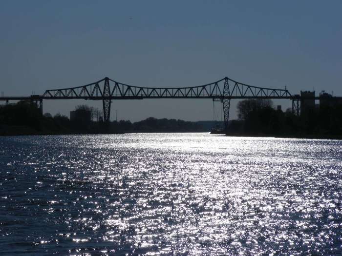
Rendsburg High Bridge spanning the Baltic-North Sea Canal. Photo taken in 2011
Touted by many to be the most beautiful state in Germany, Schleswig-Holstein offers a mixture of landscapes and climates to attract the vacationer wishing to escape the city life. It is sandwiched by two different seas- the North Sea in the west and the Baltic Sea in the east, each offering different forms of flora and fauna as well as Schietwetter (storms producing high winds, torrential downpours and high tides). The Baltic-North Sea Canal, connecting the state capital of Kiel with Brunsbüttel via Rendsburg slices the state into two, even though the 1895 canal replaced a 1700s canal that complimented the longest river in the state, the Eider. That river starts near Kiel and ends in the North Sea, but not before passing through bridge-laden towns of Rendsburg, Friedrichstadt and Tönning, while at the same time, connecting with the rivers Treene and Sorge.
The hills east of Kiel and in the Seegeberg region provides a great backdrop for photographers wishing to get some pictures of scenery along the river Schwentine, which also gets its additional water from the lakes region near Plön and Eutin, located between Kiel and Lübeck. At the same time, the state is bordered to the south and east by two major waterways: the Elbe to the south and the 80 kilometer long Lauenburg-Lübeck Canal to the east. From Lübeck going north into Denmark, the state receives additional water from the Baltic Sea in the form of fjords, found in Kiel, the Schlei region and Flensburg. The western half is characterized by flat plains with gullies and diversion canals to channel water and protect farmlands and beaches from flooding.
Stone Arch Bridge in Friedrichstadt: the oldest in the Dutch community at 240+ years. Photo taken in August 2017
With all this water, one needs to cross it- by bridge!
Many books have been written about the history of places in Schleswig-Holstein and the different regions full of natural habitats and historic places of interest. There are enough books on light houses (including the famous Westerhever), windmills (like the ones in the Dithmarschen, Schleswig and Ostholstein districts), and holiday resorts (like St. Peter-Ording, Travemünde and Fehmarn) to fill up a library section, just with those alone. There is even a book on the Faces of Flensburg, focusing on the people who made the former rum capital and key port famous, including the founder of the adult entertainment store, Beate Uhse, who opened the world’s first store of this type in 1962.
Bridge of Friendship at the German-Danish border north of Flensburg. Photo taken in 2010
Yet with many bridges in Schleswig-Holstein- many of which have histories going back over 100 years, only two books have been written about this topic: one on the bridges along the Baltic-North Sea Canal, one on the dual draw bridge north of Lübeck (which no longer exists). The most recent book, published last year, commemorated the centennial of the two-span arch bridge in Friedrichstadt, whose drawbridge span allows for passage along the Eider. Not even a book on the Fehmarn Bridge, the world’s first basket-handle tied arch bridge has been written.
White Draw Bridge in Tönning
This leads us to the question of why we’ve neglected to write about the other bridges in the state.
Since 2011, I’ve been photographing and writing about some of the bridges in the state, which includes the cities of Kiel, Flensburg, Lübeck and Friedrichstadt as well as the bridges along the Baltic-North Sea Canal, wondering what they looked like a century before, how they were built and who built them. In addition, research is being undertaken to find out what other bridges exist in the present, had existed before getting replaced by modern structures and who were behind the building of the bridges. Even more interesting is the role of bridge engineers in Schleswig-Holstein, as the state imported many famous ones, like Friedrich Voss and Hermann Muthesius but exported just as many to other regions in Germany, Europe and even the United States. Lawrence H. Johnson was one of those who made his mark both as a bridge builder and a politician- in the state of Minnesota!
One of many pedestrian crossings over the gullies and canals at Westerhever Lighthouse
With as much work put in as possible, the decision has been made to write a book on the bridges in Schleswig-Holstein. This five-year project will focus on the bridges, past and present, which has shaped the state and its infrastructure, while at the same time, fostered tourism, business and commerce, especially over the last 150+ years. At the same time, however, we will look at the engineers who left their mark in the state while those, who originated from S-H, emigrated to other places to leave their legacies. The work will be written in three languages: German, English and Danish, reflecting on the languages of the residents and those who are interested in reading this piece and visiting the sites.
I’m looking for the following in order to complete this book project:
Old photos, postcards and information on the bridges in Schleswig-Holstein, especially including the previous crossings (those that were replaced with today’s modern structures) and ones that no longer exists. This includes bridges in towns and cities as well as along the rivers: Stör, Eider, Sorge, Trave, Aarau, Treene and Schwentine, and also those along the canals: Alte Eider, Lauenburg-Lübeck and Gieselau.
Stories about the bridges in Schleswig-Holstein that are memorable and worth mentioning in the book. Already mentioned in the book on the Eider Bridge in Friedrichstadt, sometimes stories and memories about the bridge makes the crossing one worth remembering.
Information on the bridge engineers in Schleswig-Holstein who left their mark in bridge building, apart from Friedrich Voss as well as those who originated from the state that left their mark elsewhere, like Lawrence H. Johnson.
As the book will feature the Danish version, I’m looking for a Danish translator, preferably either a native speaker or one who has mastered the language (as the Germans would say, Sicher in Wort und Schrift)
If you have any information that will be of use for the book or would like to support the book project in anyway, shape or form, please use the contact form below and send me a line. You can also contact the Chronicles via facebook by using its messenger on its page. Additional contact information is available by request.
Please feel free to pass this information around to anyone who wants to contribute, as this is open to not only bridge experts and enthusiasts, but also locals and people who either have knowledge of the bridges in Schleswig-Holstein, are willing to help out or both.
An 1800s arch bridge spanning the River Schwentine in Kiel
With many key bridges out there (going beyond the ones that I’ve profiled), and many historic bridges being replaced with modern ones, whose lifespans are half of that of their predecessors, it is time to bring them to light. Because after all, they have just as much value to Schleswig-Holstein as the other key features the state has to offer. One has to click on the highlighted names in this article and look at the offer of books for sale at a local book store or via amazon to find out how important these structures are for the development of the state that prides itself on sailing, shipping, handball, sheep, windmills, farming, Sauerfleisch, rum, roasted potatoes, beer, Schietwetter and the famous greeting of “Moin moin!”
Stay tuned for some articles to be posted on some bridges in the Eiderstedt region, where the author vacationed for a couple weeks.
Rendsburg High Bridge in Rendsburg, Germany Photo taken by the author in April 2011
Information:
Location: Baltic-North Sea Canal at Rendsburg, Schleswig-Holstein, Germany
Description: Main span: Cantilever Warren through truss with transporter (main span), steel trestle approach span (south) and loop approach (north)
Length: 7 km (total) Of which: 2468 main span; loop approach 4.5 km
Built: 1913 by Friedrich Voss and C.H. Jocho of Dortmund
Travelling north to Flensburg on the Schleswig-Holstein-Express (the SHE) one evening in May 2010, I was chatting with four passengers heading home to the Rum capital of the world, talking about break-ups, broken marriages and partners cheating on them, when we suddenly found ourselves taking off from the ground. To think that most of the German state is flat consists of mainly farmland and coastal areas, to go from travelling on the ground to travelling in the air in a matter of seconds is like Eliott and E.T. flying in the air by bike. Yet the sound of metal to metal contact, especially when going over the steel towers revealed that whatever we were crossing was huge, the spectacular view of the lights of the town below and the body of water covered in emerald green lights was gorgeous. After going through the steel truss mechanism, we made our descent in a curly-Q fashion before touching the ground and stopping at our next station. Our conversation had stopped in favor of the structure’s admiration, a sign that homage needed to be paid to a gigantic symbol that bridges the past with the present, the lover on one place with one in the other, and the impossible with the reality.
Especially the last one is what describes the Rendsburg High Bridge, spanning the Baltic-North Sea Canal in Rendsburg, located between Hamburg and Flensburg. The bridge was the masterpiece of Friedrich Voss, who had built two other structures along the Grand Canal at Hochdonn and Kiel as well as numerous others in the northern half of the country, concluding the two-span arch bridge at Friedrichstadt. It took 1.5 years to build the main attraction along the canal, which after 104 years, it still serves as the anchor that makes the Grand Canal and Rendsburg the place to visit. What Voss did with the bridge was unthinkable, impossible and even insane in the eyes of many locals during that time. While steel trestles and a through truss design were his signatures for long-span structures like the aforementioned bridges, Voss needed a main span that would carry both horse and buggy (and later cars) as well as rail traffic. Henceforth as one of the feats, Voss chose the cantilever Warren span, whose roadway would serve rail traffic connecting Hamburg and Neumünster to the south and Flensburg and Scandanavia to the north. Hanging from the main span is the transporter span, which even today carries cars, bikes and pedestrians across the canal between Rendsburg and Aldorf. The transporter operates four times an hour in both directions during the day and takes 4-5 minutes to cross, half as long as when crossing the entire bridge via SHE.
Even more unique is the north approach. Already in existence was the train station for it served rail traffic between Kiel and Husum, the problem came with how the approach span should descend from 50 meters above water to just over zero. This was where Voss referred to the history books and chose the loop approach. Using the Hastings Spiral Bridge as reference, the loop approach provides travelers with an opportunity to gradually glide down from the bridge, making a circle of 360°. The 1895 bridge over the Mississippi River was the first bridge to feature this loop approach for engineers and bridge builders at Wisconsin Bridge and Iron Works had the problem of the bridge extending into Hasting’s business district, which already had numerous buildings and traffic at that time. Therefore, the south approach consisted of the loop approach, thus encouraging cars to glide down into the city center like a marble.
The problem was similar with the north approach, as it consisted of much of Rendsburg’s city center and housing area, combined with remnants of the old canal and the harbor area connected with the new canal. Therefore, Voss and his men devised a plan where a loop approach would feature first a series of steel trestles at the height of between 40 and 50 meters above water level, followed by earthen berms with concrete arch spans crossing main streets, after the descent of 40 meters. A Warren deck truss span crosses the rail line as it approaches the end of the loop. The total length of this loop approach alone is 4.5 km. The area the loop encircles consists of housing and therefore was later named Schleife.
On 1 October, 1913, after 1.5 years of work, Voss and 350 of his men from the bridge-building firm C.H. Jucho of Dortmund completed the work, and the bridge was open to traffic. The bridge and transporter complex has operated almost unaltered ever since, sustaining minimal damage in World War II. The bridge was rehabilitated with rust protectant being added to the steel bridge between 1993 and 2012. The rail line was electrified in 1995, which resulted in the portal and strut bracings of the through truss span being lifted. Instead of the two-rhombus portal bracing, the main span now had A-frame portals, high enough for trains to pass through. Sadly though, the transporter portion of the bridge is being replaced even as this article is being reproduced for this page. On 8 January 2016, the transporter collided with a ship as it was passing underneath the bridge. The boat operator and another passenger were injured in the wreck. After thorough investigations by the local authorities and the Ministry of Transportation, it was concluded that the transporter could not be salvaged and was therefore removed from the bridge. A replacement replicating the original transporter is currently being constructed and should be installed by 2017/18.
I had a chance to visit the bridge again in 2011, this time filming the crossing of the bridge and its transporter, but also following the path of the bridge from the start of the loop approach on the ground to the main span. While I never got a chance to see the Spiral Bridge as it was torn down in 1951, the Rendsburg High Bridge is nothing anyone has ever seen before. It is amazing just to be in a small suburb that is encircled by the loop approach, listening to trains cross it on an hourly basis. Its tall and towering trestles cannot be missed when travelling through Rendsburg. But the main span is just as amazing, for it has a total height of 68 meters, visible from 20 kilometers, making it one of the tallest structures along the Grand Canal. But I also noticed that the bridge with its wonderful work of art has not yet been recognized on the national and international scale. With the Vizcaya Bridge being nominated as a UNESCO World Heritage Site in 2013, the Firth of Forth Bridge scheduled to be nominated in 2015, the Rendsburg High Bridge Complex should be considered another UNESCO site as well because of the engineering feats that Voss accomplished in building this superstructure but also because the bridge still functions as a normal crossing of its kind today, just like it did when it opened to traffic in 1913. This is something that has made Rendsburg famous and makes it one of the wonderful works of art in Schleswig-Holstein, Germany and central Europe. Already it was given the Historische Wahrzeichen der Ingenieurbaukunst in Deutschland Award (Historic Recognition of the Works of Engineering in Germany) in 2013, on its 100th birthday. Chances are, more accolades will follow for this iron lady, whose total length of 7 kilometers (2,400 m main span) still makes it the longest railway bridge in Germany.
To close this documentary about this bridge, the third and most important part of the Tour along the Grand Canal, there is a saying that applies to any bridge enthusiast. You are never a true pontist unless you visit at least a couple key engineering works. In my book, one should really pay homage to the Rendsburg High Bridge. It is an engineering work of achievement that is underrated and something that awes every engineer to this day. Every engineer has his creative talents, which Voss had when building this bridge. It has withstood the test of time and is still a work of art one should see, when visiting Germany. It is hoped that it will one day be a UNESCO site. It will eventually for it deserves this honor.
Author’s note:
You can view the photos of the Rendsburg High Bridge via facebook site. Click here to have a look at every aspect photographed during my visit in 2011.
Some videos of the bridge can be viewed below as well:
And some links to provide you with some more information on the Rendsburg High Bridge:
This bridge was used as a logo for the Bridgehunter’s Chronicles from 2011 until its retirement and replacement with the current logo in 2015 using another Schleswig-Holstein bridge in its place, the Fehmarn Bridge. This is what the Rendsburg variant looked like.
The location of the Rendsburg High Bridge and the train station can be found on the map here:
The Stone Arch Bridge and the market square with the Dutch facaded housing in the background. Photo taken in August 2012
.
Located seven km (or four miles) south of the fourth largest city in Schleswig-Holstein, Husum, at the junction of the Eider and Treene Rivers, seven kilometers inward from the North Sea, Friedrichstadt appears to be a typical small town in the northernmost state of Germany with rows of small houses, farmland scenery with cattle and sheep grazing in the fields, and people greeting each other with “Moin! Moin!”. The town prides itself on its tourism and the typical specialties with fish, just like the rest of the cities up north. But Friedrichstadt also prides itself on its history and multiculture. Founded in 1623 by King Friedrich III and despite surviving four wars with its neighbors plus persecution of certain races, Friedrichstadt is one of the cultural points of interest, where large groups of Dutch, Frisans, Danes, Jews and Germans speaking northern dialects have lived for almost 400 years. It was a center commerce point for trade with empires from Russia, Scandanavia and Prussia, but is now a tourist attraction, where thousands of tourists from over 100 countries visit every year.
Example of one of the Dutch-style houses in the city center. Photo taken in 2017.
.
The town was built using Amsterdam as the ante-type, featuring canals that slice through the town of 2,600, but encircling its beloved Dutch-style houses, and like the Dutch capital, the city is loaded with bridges of different types and coming from different eras of time. Because of its location, Friedrichstadt is considered an island next to another island, for the community is in the Nordfriesen District, which is next to the Dithmarschen District to the south. That district is surrounded by four different bodies of water, counting the Baltic-North Sea Canal.
Eighteen Bridges can be found in this city, including two major crossings over the Eider just outside the city limits and some key notables in the town itself. Each of the crossings can be reached by foot, by bike, or by boat, with most of them telling a story or having a picture showing its history, making the town proud of its history and heritage. While one can write a library about the town’s 18 bridges, which is unusual for small town standards (a town of that size could have 3-5 bridges on average pending on location), this guide shows you the most important bridges you will see when spending a few hours in this quiet but important historic town. Each bridge has a brief history, but photos for you to see, courtesy of not only yours truly, but also many contributors, who were willing to step forward to help. The credits will be provided at the end of the article. So without further ado, we’ll start with the outer edge of town with the two Eider Bridges and work our way towards the Treene.
Inside the Friedrichstadt Arch Bridge. Photo taken in August 2012
.
Friedrichstadt Arch Bridge
Spanning the Eider River at the southwest end of town, this bridge represents one of the finest works of Friedrich Voss, who had constructed six bridges along the Baltic-North Sea Canal, including the Rendsburg High Bridge. Built in 1916, three years after the world-renowned bridge was open to rail traffic, the Friedrichstadt Arch Bridge features three spans- the center span being a two-part draw bridge; the outer spans being steel through arch bridges. When the bridge opened to traffic on December 3, 1916, it was the first structure in Germany that featured a tied-arch span made of steel. The model was later used for other spans during the 1930s and even after World War II.
Up until the 1950s, the Friedrichstadt Arch Bridge was a toll bridge, where money was gathered based on the size of the vehicles and the goods being carried across. That means one could pay 400 Pfennig for driving a truck across but only 20 Pfennig when walking across. The tolls have long since been lifted and the draw bridge span is seldom used nowadays, the bridge has received its regular wear and tear as it serves traffic in and out of Friedirchstadt from the south, connecting the town with Heide. It celebrated its 100th anniversary with a marathon and other celebrations in September 2016. Despite being renovated only once (in 2007-08), the bridge still can handle a sizeable amount of traffic today and is expected to continue to do so in the coming decades or so.
Photo courtesy of the Friedrichstadt City ArchivesPhoto taken in August 2012Side view of the bridge taken from the railroad bridge. Photo taken in 2017 Bottom two photos taken in 2021
***********
.
Sideview of the bridge before the facelift. Photo taken by H.D. Kienitz, used with permission
.
The Friedrichstadt Railroad Bridge
This bridge is one of the more popular structures in Schleswig Holstein and northern Germany. First built in 1887, the bridge featured multiple-span truss bridges with a swing span at the river crossing, with the purpose of providing passengers with rail service between Hamburg and the Island of Sylt, located in the North Sea at the Danish Border. The first bridge featured five bowstring arch spans on the north end of the Eider, followed by two Whipple through truss spans that were separated by a bowstring arch span, as shown in the picture below:
View of the 1887 Bridge. Photo courtesy of Christiane Thomsen, Friedrichstadt City Museum
.
In 1908, the spans were replaced, one by one with another set of trusses, which featured from south to north one Pennsylvania through truss with A-frame portal bracings, one bowstring arch swing span, another Pennsylvania through truss and five polygonal Warren through truss spans. Photographer H.D. Kienitz has a series of diagrams to show what the spans look like before and after the reconstruction of the crossing:
Five years later, an identical series of bridge spans was built alongside the 1908 bridge and for 74 years, the bridge provided two-way traffic before a major reconstruction job took place in 1987 and lasted seven years. It consisted of replacing the bowstring arch swing span with a polygonal Warren through truss swing span that was operated electronically and removing the 1908 span in its entirety, reducing the number of tracks on the railline to only one. This is what the bridge looks like before and after the facelift:
The duo truss bridges before the facelift in 1987. Photo taken by H.D. Kienitz, used with permission
.
The northern Warren trusses at the time of the facelift. Photo taken by H.D. Kienitz, used with permission
.
The removal of the older of the double-barrel trusses. Photo taken by H. Doose.
.
The Friedrichstadt Railroad bridge still serves traffic today, which consists of the NOB Train services, which stops regularly at Friedrichstadt, and the InterCity lines, which starts at Westerland on the Island of Sylt and runs through Hamburg going to destinations in the south. As part of the project to electrify the railroad line in the next 5-10 years, the bridge was extensively rehabilitated in 2020-21 to prolong its life by another 40 years. It is unknown whether there will be another two-track bridge built at this site as part of the project. It depends on the number of passengers travelling through the western part of Schleswig-Holstein and the problem with bottlenecks at this site. Should there be the need for another track and crossing, the new bridge will likely be built at the site of the one that was removed by 1994. Right now, with four national raillines and the options available for rail travel in the region, it appears unlikely. That might change in the coming years or so….
Photo of the main spans after the facelift. Photo taken in 1997 by H. Doose, used with permission.
.
View of the Friedrichstadt Railroad Bridge from the Friedrichstadt Arch Bridge. Photo taken in August 2012
.
Apart from the InterCity line connecting Sylt and Hamburg, the three other national lines include Hamburg-Luebeck- Copenhagen (crossing the Fehmarn Bridge), Hamburg-Rendsburg-Flensburg-Kolding (crossing the Rendsburg High Bridge) and Hamburg-Neumuenster-Kiel. While the ICE trains run on the lines to Kolding and Kiel, plans are in the making to construct a pair of tunnels going through Fehmarn to connect Germany with Denmark and hence, the ICE line to Copenhagen will be in service by 2030.
Prior to the construction of the Railroad Bridge in 1887, there were no crossings along the Eider for the last 100 km from Rendsburg to the mouth at the North Sea. Since the completion of the two crossings in Friedrichstadt, four more crossings have been built- the youngest at Tönning was constructed in 1975.
*******
Side view of the Stone Arch Bridge and the canal. Photo taken in 2017.
.
The Arch Bridges of Friedrichstadt:
It is unknown how many arch bridges were built during the time of the town’s infancy. But if one counts the 1916 Eider crossing, there are four arch bridges you can find in Friedrichstadt today, regardless of its shape and form. The oldest known stone arch bridge in Schleswig-Holstein and one of the oldest in Germany is the famous Stone Arch Bridge. Built in 1773, the 20-meter long structure is located at the market square on the north end, spanning the Mittelburggraben. Since its rehabilitation in 1981 (where the bridge was strengthened and widened to accommodate traffic, it has become one of the most photographed structures in Friedrichstadt and in the state. The bridge provides tourists who eat at the ice cream parlor next to it with a picturesque background of the city. The Red Arch Bridge at the street Am Deich is a 20+ meter long structure that was constructed in 1867. That can be found next to the main highway, Tönninger Strasse (Highway B 202). The youngest of the arch bridges is the Hebammenbrücke, located at Mittelgrabenstrasse. The bridge was built in the 1990s and is a modern structure made of concrete and steel. It serves pedestrians. Both span Ostersielzug with the latter being located next to the police station. The bridges are best photographed while doing a paddle boat or canoe tour, something Friedrichstadt offers to allow tourists to witness life in a typically Dutch town surrounded by canals.
Passenger Boat passing through the Stone Arch Bridge. Photo taken in August 2012
Painting of the Holmertor Bridge before its replacement. Photo courtesy of the Friedrichstadt City Archives
*****
Cyclist crossing the Holmertor Bridge. Photo taken in 2012
.
Wooden Bridges in Friedrichstadt
It is unknown how many wooden bridges existed in Friedrichstadt, for they differed on location and design. But today there are at least four bridges remaining that were built made of wood, most of which feature triangular deck trusses supporting wooden support piers and three of which can be found along the northern Mitteburgwall Canal, the same one where the Stone Arch Bridge is located. A pair of notable bridges should be noted here. The Middle Bridge, located next to the Stone Arch Bridge, is known as the Holmertor Bridge and featured a bascule bridge supported by a wooden tower, as depicted in a painting provided by the city. It was replaced at the end of the 19th century. The Kuhbruecke (Cows Bridge) is located at the mouth of the Treene adjacent to the Blue Bridge and is the third bridge located at the site. A lock is located right next to it and protects the town from flooding from the Treene River.
Photo taken in August 2012
.
Blue Bridge:
The final bridge on this tour is the Blue Bridge. Located over the Treene River in the district of Westersielzug, this bridge is the only one in the city that features a double leaf bascule bridge, one of the most common types of bridges to be found in Schleswig-Holstein. Yet this bridge represents a historic symbol for the city as about a handful of these bridges were constructed in the 1800s, including this bridge which has a separate profile as a Mystery Bridge. That bridge was located in the same district as the Blue Bridge, according to the City Archives. Serving as a gateway to the historic city center from the north (and the train station), the Blue Bridge was constructed in 1991 to serve as a historic marker to the bridges that have long since been lost. However, the main spans were lifted only once in its lifetime. Reason? While the plan was to use the Treene as a thoroughfare, it was blocked thanks to a fixed span located to the west of the bridge. Since then, the bridge practically serves as a fixed span, even though technically it is a bascule bridge. Nevertheless, it is mentioned a great deal through boat tours and other notes in the travel guides and is a treat to those wanting to visit Friedrichstadt.
Author’s Note: The fixed span mentioned here has been in service since the 1970s. Its predecessor was the Kreisbahnbrücke, a polygonal Warren pony truss bridge that used to carry trolly traffic to the city from the train station.
Kreisbahnbruecke. Photo courtesy of the Friedrichstadt City Archives
.
Fazit:
To sum up, Friedrichstadt is a city full of history and surprises, no matter which aspect one is interested in. The city has 18 bridges, which is unusual, however, each one tells a story, which is worth listening to or reading about when spending time there, regardless of bridge type and size. The city may be small, but its history and heritage makes Friedrichstadt a must-see place when visiting Schleswig-Holstein.
A map of the bridges is enclosed so you know of their location:
The author would like to thank Christiane Thomsen at the Friedrichstadt City Archives, Rainer Butenschoen, Dietrich Doose and H.D. Kienitz for their help in providing information and photos on the bridges in Friedrichstadt.
Rendsburg High Bridge in Rendsburg, Germany Photo taken by the author in April 2011
Information:
Location: Baltic-North Sea Canal at Rendsburg, Schleswig-Holstein, Germany
Description: Main span: Cantilever Warren through truss with transporter (main span), steel trestle approach span (south) and loop approach (north)
Length: 7 km (total) Of which: 2468 main span; loop approach 4.5 km
Built: 1913 by Friedrich Voss and C.H. Jocho of Dortmund
Travelling north to Flensburg on the Schleswig-Holstein-Express (the SHE) one evening in May 2010, I was chatting with four passengers heading home to the Rum capital of the world, talking about break-ups, broken marriages and partners cheating on them, when we suddenly found ourselves taking off from the ground. To think that most of the German state is flat consists of mainly farmland and coastal areas, to go from travelling on the ground to travelling in the air in a matter of seconds is like Eliott and E.T. flying in the air by bike. Yet the sound of metal to metal contact, especially when going over the steel towers revealed that whatever we were crossing was huge, the spectacular view of the lights of the town below and the body of water covered in emerald green lights was gorgeous. After going through the steel truss mechanism, we made our descent in a curly-Q fashion before touching the ground and stopping at our next station. Our conversation had stopped in favor of the structure’s admiration, a sign that homage needed to be paid to a gigantic symbol that bridges the past with the present, the lover on one place with one in the other, and the impossible with the reality.
Especially the last one is what describes the Rendsburg High Bridge, spanning the Baltic-North Sea Canal in Rendsburg, located between Hamburg and Flensburg. The bridge was the masterpiece of Friedrich Voss, who had built two other structures along the Grand Canal at Hochdonn and Kiel as well as numerous others in the northern half of the country, concluding the two-span arch bridge at Friedrichstadt. It took 1.5 years to build the main attraction along the canal, which after 101 years, it still serves as the anchor that makes the Grand Canal and Rendsburg the place to visit. What Voss did with the bridge was unthinkable, impossible and even insane in the eyes of many locals during that time. While steel trestles and a through truss design were his signatures for long-span structures like the aforementioned bridges, Voss needed a main span that would carry both horse and buggy (and later cars) as well as rail traffic. Henceforth as one of the feats, Voss chose the cantilever Warren span, whose roadway would serve rail traffic connecting Hamburg and Neumünster to the south and Flensburg and Scandanavia to the north. Hanging from the main span is the transporter span, which even today carries cars, bikes and pedestrians across the canal between Rendsburg and Aldorf. The transporter operates four times an hour in both directions during the day and takes 4-5 minutes to cross, half as long as when crossing the entire bridge via SHE.
Even more unique is the north approach. Already in existence was the train station for it served rail traffic between Kiel and Husum, the problem came with how the approach span should descend from 50 meters above water to just over zero. This was where Voss referred to the history books and chose the loop approach. Using the Hastings Spiral Bridge as reference, the loop approach provides travelers with an opportunity to gradually glide down from the bridge, making a circle of 360°. The 1895 bridge over the Mississippi River was the first bridge to feature this loop approach for engineers and bridge builders at Wisconsin Bridge and Iron Works had the problem of the bridge extending into Hasting’s business district, which already had numerous buildings and traffic at that time. Therefore, the south approach consisted of the loop approach, thus encouraging cars to glide down into the city center like a marble.
The problem was similar with the north approach, as it consisted of much of Rendsburg’s city center and housing area, combined with remnants of the old canal and the harbor area connected with the new canal. Therefore, Voss and his men devised a plan where a loop approach would feature first a series of steel trestles at the height of between 40 and 50 meters above water level, followed by earthen berms with concrete arch spans crossing main streets, after the descent of 40 meters. A Warren deck truss span crosses the rail line as it approaches the end of the loop. The total length of this loop approach alone is 4.5 km. The area the loop encircles consists of housing and therefore was later named Schleife.
On 1 October, 1913, after 1.5 years of work, Voss and 350 of his men from the bridge-building firm C.H. Jucho of Dortmund completed the work and the bridge was open to traffic. The bridge and transporter complex has operated almost unaltered ever since, sustaining minimal damage in World War II. The bridge was rehabilitated with rust protectant being added to the steel bridge between 1993 and 2012. The rail line was electrified in 1995, which resulted in the portal and strut bracings of the through truss span being lifted. Instead of the two-rhombus portal bracing, the main span now had A-frame portals, high enough for trains to pass through.
I had a chance to visit the bridge again in 2011, this time filming the crossing of the bridge and its transporter, but also following the path of the bridge from the start of the loop approach on the ground to the main span. While I never got a chance to see the Spiral Bridge as it was torn down in 1951, the Rendsburg High Bridge is nothing anyone has ever seen before. It is amazing just to be in a small suburb that is encircled by the loop approach, listening to trains cross it on an hourly basis. Its tall and towering trestles cannot be missed when travelling through Rendsburg. But the main span is just as amazing, for it has a total height of 68 meters, visible from 20 kilometers, making it one of the tallest structures along the Grand Canal. But I also noticed that the bridge with its wonderful work of art has not yet been recognized on the national and international scale. With the Vizcaya Bridge being nominated as a UNESCO World Heritage Site in 2013, the Firth of Forth Bridge scheduled to be nominated in 2015, the Rendsburg High Bridge Complex should be considered another UNESCO site as well because of the engineering feats that Voss accomplished in building this superstructure but also because the bridge still functions as a normal crossing of its kind today, just like it did when it opened to traffic in 1913. This is something that has made Rendsburg famous and makes it one of the wonderful works of art in Schleswig-Holstein, Germany and central Europe. Already it was given the Historische Wahrzeichen der Ingenieurbaukunst in Deutschland Award (Historic Recognition of the Works of Engineering in Germany) in 2013, on its 100th birthday. Chances are, more accolades will follow for this iron lady, whose total length of 7 kilometers (2,400 m main span) still makes it the longest railway bridge in Germany.
To close this documentary about this bridge, the third and most important part of the Tour along the Grand Canal, there is a saying that applies to any bridge enthusiast. You are never a true pontist unless you visit at least a couple key engineering works. In my book, one should really pay homage to the Rendsburg High Bridge. It is an engineering work of achievement that is underrated and something that awes every engineer to this day. Every engineer has his creative talents, which Voss had when building this bridge. It has withstood the test of time and is still a work of art one should see, when visiting Germany. It is hoped that it will one day be a UNESCO site. It will eventually for it deserves this honor.
Author’s note:
You can view the photos of the Rendsburg High Bridge via facebook site. Click here to have a look at every aspect photographed during my visit in 2011.
Some videos of the bridge can be viewed below as well:
And some links to provide you with some more information on the Rendsburg High Bridge:
Lastly, the Bridgehunter’s Chronicles is sending off its logo, which goes by the design of the main span of the Rendsburg High Bridge. From now on, it will use a new logo, using another bridge to be profiled very soon, also located in Schleswig-Holstein, the Fehmarn Bridge. Here’s a farewell with many thanks to the old iron lady for being the source of inspiration into creating this unique logo:
Underneath the Europabruecke near Rendsburg. Photo taken in May 2011
After a stop in Kiel, Friedrichstadt and the Alter Eider Canal, our next stop on the tour of the canal area in northern and central Schleswig-Holstein is the bridges along the Grand Canal itself, known as the Baltic-North Sea Canal (in German: Nord-Ostsee Kanal.To understand more about the canal, one has to look at the history of it, which is plentiful in color. We already know that the first canal followed the same path as the river Eider, swerving about like a snake through Knoop, Rathmannsdorf, Kluvensiek and Schinkeln, running parallel to the present day canal between Kiel and Rendsburg before taking a more northerly route in the direction of Friedrichstadt and Tönnern before emptying into the North Sea. As the decades wore on however, the boat traffic increased in size and volume and despite its unique construction, the canal locks, let alone the double-leaf bascule bridges built to cater to horse and buggy at that time, were no longer able to accommodate the marine traffic. Therefore beginning in 1887, engineers of the German Navy embarked on a plan to construct a newer and wider canal that would run straighter than the Alter Eider and on a shorter length than its predecessor so that in the end, the Grand Canal would flow southwesterly from Rendsburg, past Gruenental and Hochdonn, and emptying into the North Sea at Brunsbüttel, approximately 65 km south of Friedrichstadt. The length totalled 90 km, which is more than half the distance of the Eider Canal. While the canal was built as a means of providing a short naval route instead of going around Denmark, the Grand Canal today serves as a shortcut for the shipping and commerce.
Ten Bridges serve the Canal, including the Rendsburg High Bridge. Yet because of its historic and technical significance, a separate article accompanies this one as part of the series on the Bridges of the Grand Canal. The following profiles features bridges that you can see when travelling along the canal, going from Kiel to Brunsbüttel:
Olympia Bridge (left) and Prince Heinrich Bridge (right). Photo taken in May 2011
Prince Heinrich and Olympia Bridges: The twin bridges, with the identical shape and color are the first bridges to see when entering the Grand Canal from the Kiel side. They are located 700 meters from the first canal lock from the side of the Baltic Sea. Yet they have been together since 1996. Before that, there was a true landmark that was part of Kiel’s heritage. While the first bridge consisted of a combination of a pontoon and swing bridge, which opened to allow ships to pass, the 1912 truss and trestle bridge replaced the 17-year old temporary structure. It was one of the first architectural artwork designed by Friedrich Voss, the same person who built the Rendsburg High Bridge (which will be discussed in a separate article), and the Friedrichstadt Arch Bridge (which you will find here). The 320 meter long bridge featured two deck trusses supported by steel trestles resembling a bow tie and a 110 meter long subdivided Warren through truss with riveted connections and a V-frame portal bracing (also subdivided). A link with post cards of the bridge can be found here. While the bridge sustained substantial damage during World War II, it was repaired and served as a single lane bridge connecting Kiel and its suburb Holtenau until 1972, when an additional bridge was deemed necessary as part of the plan to convert the road into an expressway. The Olympia Bridge was 150 meters longer than Prince Heinrich, yet the decision on which bridge type to build remains to this day a controversial subject. While the majority of the residents favored an identical truss design, their plea fell on deaf ears as the Kiel city council voted for a steel deck girder bridge. For 19 years, the two bridges served traffic, with the Olympia Bridge serving traffic going to Holtenau; Prince Heinrich going to Kiel. Yet due to extreme corrosion on the truss bridge, the two communities voted unanimously in 1990 to replace the 1912 bridge with an identical deck girder bridge. Again the decision was against the will of the majority who favored a cable-stayed bridge instead of the design chosen by then state representative Gerhard Stoltenberg. The truss bridge was demolished during the summer of 1992. During the dismantling process, the eastern approach span collapsed on its own in August, taking two cranes with. Fortunately no one was injured. As soon as the bridge was removed, the replacement span was built, taking 58 months complete. Reason: design and construction flaws combined with increasing costs resulted in delays in its construction and impatience among the Kiel city council. Yet when the new span was completed, the bridge resembled its sister span the Olympia Bridge. Since 1997, both bridges have been serving the expressway connecting Kiel and Holtenau with the replacement bridge serving the role once taken by Prince Heinrich. Yet for many in Kiel, the bridges serve as an eyesore for the decision to build a modern bridge was against their will for they wanted something that the city can be proud of and not something bland. The aesthetics of the bridge today are questionable even from the author’s point of view, but if there is a consolation, the bridges serve as a marker
Located just 10 km west of the Olympia and Prince Heinrich Bridges, this bridge is unique because of its unique design. Made of steel, this bridge features a half-pony and half deck arch design. Built in 1894 by Hermann Muthesius, it used to feature a through truss design in a form of a Howe design. Its decking featured rail traffic between Kiel and Flensburg for the eastern half and vehicular traffic for the western half. A picture of the bridge can be found here. Yet, as mentioned in the bridge quiz a few weeks ago, the bridge became a safety hazard by the early 1950s, as collisions at the portal entry were the norm- in many cases with injuries involved. Henceforth, beginning in 1952 and lasting for two years, the through truss portion and the concrete portal entries were removed, the roadways were reallocated and separated with a barrier to ensure through traffic and better passage, additional steel supports were added to the deck arch sections, and the entire bridge was stripped down to resemble its present form today. The stripped down version of the Levensau Bridge was reopened to traffic in 1954 and continued to be the lone link between Kiel and Levensau for another 20 years. An additional bridge was added to relieve the bridge of heavy masses of traffic in 1974. The bridge still remains in use, yet its days will soon be numbered. Plans are in the making to demolish the bridge and replace it with a tied arch span as part of the plans to widen and deepen the Grand Canal. At present, no work has been done on the bridge because of issues with a rare species of bats residing in the deck arch portion of the bridge. Since they are protected by law, the Ministry of Environment would have to approve a plan to relocate the animals before work commences on this bridge. Once it starts, the project should last 1-2 years but the abutments of the 1894 bridge will remain as observation points.
Oblique view of Europebruecke near Rendsburg. Photo taken in May 2011
Rendsburg’s Highway Bridge and Tunnel:
About a third of the way down the canal we come to Rendsburg, a city of 30,000 that once prided itself on the cast iron industry, but is now simply a tourist trap. Rendsburg is a rather quiet community with friendly people who enjoy talking about its heritage and history. And the city should be proud of it, especially when it comes to its bridges. Several bascule bridges were erected over the Alt Eider Canal in and around Rendsburg, most of which were built by the cast iron company Carlshütte (for more information, please refer to Part I and the Kluvensiek Bridge). Yet as iron became a fad of the past thanks to the coming of steel, so was the canal itself as the Grand Canal replaced it and effectively made these bridges obsolete. Today another landmark overshadows the city, which we’ll talk about in the next article with the Rendsburg High Bridge, yet two other crossings existed over the Grand Canal: The City Tunnel and the Europe Bridge. The City Tunnel was built in 1961, replacing the steel swing bridge, built using a cantilever truss design. That bridge featured two spans, each with a turning wheel, that would turn outwards to allow ships to pass. Because of the traffic congestion along the main street going through Rendsburg which the bridge carried, combined with the rust and corrosion and the hindrance of marine traffic, that bridge was taken out of service in favor of two tunnels, each one carrying one-way traffic. Two additional tunnels for bikes and pedestrians were added in 1965. At the same time of the construction of the tunnel, plans were approved to construct an Autobahn-Bridge spanning the Grand Canal. The 1491 meter long bridge (with a 221 meter main span) was christened the Europabrücke, as it not only connected Flensburg and Hamburg via A7, but it created the longest Autobahn in not only Germany (at 961 kilometers in length), but Europe, connecting Flensburg with Füssen in Bavaria, but Scandanavia (namely Kolding, Aalborg, Copenhagen and Stockholm) with the Alps region (and with it, Austria and Switzerland). The bridge has been serving traffic since its opening in 1972.
Oblique view of Grünental Bridge. Photo taken in 1987 by Rainer Butenschön, used with permission
Located near the town of Beldorf, this 1892 structure, featuring a half through and half arch bridge and serving a local road and railroad line. Little has been mentioned about this bridge except for the fact that it is most likely the second bridge built along the canal by Hermann Muthesius, the same person who built the Levensau Bridge near Kiel. Furthermore, it was one of two bridges in Schleswig-Holstein that carried both vehicular and rail traffic (the Heide- Neumuenster Line). The Lindaunis Schlei drawbridge is the other bridge. The bridge served traffic for 92 years before severe rust and corrosion on the superstructure led to first a severe weight restriction, forbidding trucks from using the bridge, later the German Railways to cease train service across the bridge, and finally its eventual replacement with the present structure, a Warren through truss bridge with no vertical beams. The arch bridge, deemed unsafe even for pedestrian use, was taken off its foundation using two massive cranes in 1988 and cut up and hauled away for scrap metal. Only the brick abutments, once used as portal entrance before its partial demolition in 1952, remain as observation decks. Unique is the fact that the state shield of Schleswig-Holstein, made of iron, can be seen while passing under the new bridge.
Portal view of the bridge with the new bridge in the background. Photo taken in 1987 by Rainer Butenschön, used with permission
Main span of Hochdonn Bridge. Photo taken by Rainer Butenschön. Used with permission
Featuring Warren deck truss approaches supported by steel bowtie-like trestle towers and a Camelback Warren through truss main span over the canal, the 2218 meter long Hochdonn Viaduct cannot be missed while travelling along the Grand Canal. Built between 1913 and 1920, this bridge is possibly the third bridge built by Friedrich Voss, who had previously built the Prince Heinrich Bridge near Kiel in 1912 and the Rendsburg High Bridge , one year later. It replaced a swing bridge located west of Hochdonn, which was removed and replaced with a ferry today. Since its opening in 1920, the bridge has been serving rail traffic between Hamburg and the Island of Sylt, located at the German-Danish border. The only work done on this bridge was between 2005 and 2008, when the deck truss trestle spans were rehabilitated and the 42 meter high main span was replaced with a replica of the original bridge. In historic standards, it would have compromised the bridge’s historical integrity, but given the circumstances, and the fact that the truss swapping was necessary because the original span sustained severe corrosion making the rehabilitation impossible, it was deemed necessary to carry out this work while keeping the bridge’s integrity in tact. It has worked, as the bridge is still considered historically significant on the state level. A link with detailed photos of the bridge can be found here.
Deck truss approach spans. Photo taken by Rainer Butenschön, used with permission
The last two bridges crossing the canal are not only the westernmost bridges, but they serve the main artery connecting Hamburg and the Island of Sylt, passing through the cities of Itzehoe, Husum and Heide. The Hohenhorn Viaduct, built in 1989, is the younger of the two bridges, and serves the Autobahn motorway 23, which connects Heide and Hamburg. It was built as a relief to the main highway 5, although stretches of them have been replaced by the motorway since then. It still serves traffic today. The 390 meter long bridge features a similar main-span steel cantilever bridge to that of the Europa Bridge, but it one of the shortest bridges along the canal.
At 2831 meters long, the Brunsbüttel Bridge, the last bridge before approaching the North Sea, serves the Main Highway 5, which runs along the North Sea coast. Built in 1983, the bridge, which featured a Warren through truss main span and two deck girder approach spans, is not only the longest bridge over the Grand Canal, but it is also one of the longest bridges in Germany. Given the landscape where the bridge is located, the bridge can be easily seen from a distance of as far as 10 kilometers in both directions.
To sum up the tour of the Bridges along the Baltic-North Sea Canal, the canal is rich in history, not only in its construction and how the towns profited from it, but also the bridges that either used to cross it or still cross it. There are many bridges in shapes and sized that a person can see. Yet there is one bridge that was left out of all this, which we will get to as we approach Part III: The Rendsburg High Bridge.
Author’s Note: To view the other articles on the bridges in the canal area, please refer to the following links that you can click on:
Also some details are available just by clicking on the words underlined. Some are in German but also some in English.
Special Thanks to Rainer Butenschön for the photos of the Hochdonn and Grünental Bridges and for allowing the author to use a couple of them for this article.
When traveling home to southwestern Minnesota from the Twin Cities, it is almost always natural to take the shortest possible route so that one can reach their destination in the shortest time possible, whether it is through Mankato or Albert Lea. When I travel home to southwestern Minnesota from the Twin Cities (which is my preferred destination for all German-American flights), I usually take a more scenic route, which is along the Mississippi River and through parts of southeastern Minnesota, passing through Northfield and Fairibault. The area is filled with a variety of landscapes to choose from, from hilly to flat all in the span of 30 miles. There are numerous towns and villages to see, including Hampton and New Trier, which is rich with history and heritage. But there is another reason for traveling through the area, to pay homage to a blue beauty over the Ole Miss.
The Hastings High Bridge is one of my most favorite historic bridges in the state of Minnesota. Built in 1951 by Sverdrup and Parcel, the same company that built the first I-35W Bridge in Minneapolis, this through arch/truss bridge is the only one of its kind in the state and one of a handful of bridges of its kind remaining in the US. It is one of the longest in the Upper Mississippi River Valley, at 1857 feet (the arch span being 600 feet) and is one of the towering figures of the City of Hastings.
The bridge also has a deep history which makes it one of the icons of the city of 18,000. It was here that the first bridge with a spiral approach was built in 1895. Designed and built by the Wisconsin Bridge and Iron Works Company (WisBI), the original Hastings Spiral Bridge featured a Parker through truss bridge as the main span followed by two wooden and steel trestle approaches. Because a high bridge was needed to clear the height clearance for ships and barges to pass through, an engineer at WisBI constructed a spiral approach in the shape of a curly Q on the south end of the bridge, providing drivers with a chance to make an easy descent into the historic business district. The bridge became a treat for the city of Hastings and it became a poster boy for many engineers to design bridges with this spiral approach. This includes Friedrich Voss, who adopted this unique approach design for the railroad viaduct in Rendsburg, Germany, which was built in 1913 and features a spiral approach on the north end made of a combination of a grade, arch bridges over streets and steel trestles slicing through the city before approaching the main span- a cantilever through truss with a transporter underneath, spanning the Baltic-North Sea Canal. It is still in service today and is the only one of its kind in the world. Even today, these bridges were being built, big or small, and regardless of what they carry for vehicles and people, like the pedestrian bridge in Bad Homburg vor der Hoehe, near Frankfurt/Main in the German state of Hesse.
Pedestrian Bridge at Bad Homburg near Frankfurt/Main. Photo taken in February 2008
Spiral approach of the Rendsburg High Bridge. Photo taken in April 2011
Main span of Rendsburg High Bridge. Photo taken in April 2011
Sadly, the bridge showed sign of wear and tear and in 1951, it was replaced with the current structure. The future of the Spiral Bridge was in doubt as many people wanted to keep this historic icon, yet despite the split decision, a pocket vote on the part of Hastings’ mayor sealed the structure’s fate, and the bridge was brought down by explosives, as seen in the video here. As a consolation, one of the piers was preserved as a historical marker. However, a replica of the bridge was built in 2005, using a Thacher through truss bridge imported from Lac Qui Parle County. It is now at the Little Log House Pioneer Village, located south of Hastings.
Now the fate of the second bridge seems to be sealed. After 61 years in service, the bridge is being replaced by a tied arch bridge, which is supposed to be the longest in the western Hemisphere. Like the Spiral Bridge, the High Bridge showed signs of wear and tear, caused by increase in traffic combined with weather extremities. Even salt used for deicing the roadway has eaten away at the structure to a point where the cost for rehabilitation would be exorbitant. There are many who believe that it is not necessary for a new bridge to be built at the site of the present one. Yet the question is where should the new bridge have been built without having a negative impact on the city’s commerce? That question is difficult to answer and probably will not be presented until after the 1951 structure comes down in 2013.
Yet the people in Hastings and the surrounding area welcome the change as many are afraid that the structure will collapse. Little do they realize is they are losing another important icon, which could have been saved, had there been ways to rehabilitate it years earlier and most importantly, maintained it. The bridge’s heavy steel used for the structure provided truckers and commuters with a sense of security that it was meant to last for 100 years, as is the case for many railroad truss bridges. Yet with as much traffic as US Hwy. 61 carries through Hastings, maintaining it would mean painting the bridge biannually at least, as it is seen with the maintenance on the Golden Gate Bridge in San Francisco. The costs would be high and with the current economic problems we are facing, it would have been impossible to keep up the maintenance on the bridge. But one should expect to dole out the funds for the new bridge as well, as it will need just as much tender loving care as the first two crossings.
We have seen many of Minnesota’s historic relicts (bridge’s included) become part of the history books, as seen in Jack El Hai’s Lost Minnesota, published in 2005. I’m sure that a second volume is in the making and that this bridge will be in there with others that have fallen victim of modernization, including its neighboring bridge to the north at Inver Grove Heights. Even though the new bridge will present a sleek design made to entice the modernists and passers-by, many people in Hastings as well as those with connections with the High Bridge will remind them of the icon that will be soon by history. It is unclear whether this bridge will last as long as the first two, but it will take time for the people of Hastings to adapt to the new bridge.
While I’ll probably visit the bridge on my next USA trip in 2013, I will always think of the Blue Beauty over the Ole Miss. And therefore, as a tribute to one of the finest landmark bridges, I’ve enclosed a gallery of bridge photos for you to enjoy, which you can click here to view. A video of the trip across the bridge can be seen here.
Side view taken from the city park. Photo taken in Dec. 2007
Oblique view. Note the retailer building was removed to make way for the new bridge. Photo taken in December 2007
Behind the portal bracing. Photo taken in Dec. 2007
Oblique view from underneath. Photo taken in December 2007
Photo taken in September 2010
Approaching the bridge and Hastings. Photo taken in Dec 2010
Hastings Bridge during construction. Photo taken in August 2011
Photo taken in August 2011
The Hastings Bridge in the background with the new bridge’s piers in the foreground. Photo taken in August 2011
The next three segments of the bridgehunting tour in Schleswig-Holstein, which was taken in April of this year, deal with the historic bridges along the Baltic-North Sea Canal. The Grand Canal geographically slices the northernmost German state into two, ironically Schleswig in the northern half and Holstein in the southern half. The east terminus is located in the northern edge of the state capital of Kiel, where ships can enter the Baltic Sea. The western (or North Sea) terminus is located near the city of Heide. While the current canal was constructed between 1885 and 1890 under the direction of Reeder Dalhström and Friedrich Voss (for the bridges), the origin of the canal dates back to 1784 when it was completed. While both canals run parallel to each other, the newer (and current) canal runs a straighter course, cutting the distance down to 95km instead of 160km as the older (and now defunct canal) had. Nevertheless, both canals have a chest full of stories of their past, which includes the history of the bridges that span them. The first segment will deal with the first segment of the old canal (known today as the Alte Eider Canal), which ran in an S-shaped fashion from Kiel to Rendsburg. The second segment will handle the western half of the old canal, which is today considered the River Eider and empties into the North Sea near Husum. And finally, the last segment will focus on the bridges along the present canal, most of whom were built by Friedrich Voss and it includes the Rendsburg High Bridge, which will be featured as a separate segment in itself because of its unique design. While the author was only able to photograph the bridges between Kiel and Rendsburg, there are other contributors who were nice enough to assist in the addition of their photos in areas that need it the most. These names will be mentioned accordingly and the author is thankful for their assistance. PART I: THE ALTE EIDER CANAL BETWEEN KIEL AND RENDSBURG
Lock at Rathmannsdorf minus the bridge removed. Photo taken in April 2011
After an hour of lunch, combined with a trek combing up along the west end of the Kieler Fjorde, passing the university and the state parliamentary building along the way, I ended up in the northernmost suburb of Holtenau, the starting point of the Grand Canal. Measuring about 95 km long and approximately 60 meters wide in many areas, it resembled the Panama Canal, which slices through the isthmus connecting North and South America. The only difference between the two is the landscape, which the Grand Canal goes through mostly flat land. Before the trip to Kiel to start on the journey, I bought a magazine bearing the name “Nord-Ostsee-Kanal” 2011 version from a book store in Flensburg and while staying at the hotel on the city’s east end of Mürwik, I learned about the canal’s history, let alone the origins, and decided to make a parallel bike tour where I could find and photograph the bridges along both canals, although I would risk not getting from Kiel to Heide before sundown. While my prediction did come true, there was no regret doing what I did, for I would not have had the chance to share my experiences travelling along the Alte Eider and the Grand Canals at the same time.
The Alte Eider Canal had a width of about 30 meters and was 4 meters deep in many areas. While its starting point was in Kiel Holtenau, its path represented a long snake slithering quietly through the flat lands, as the canal made a lot of really sharp turns. Since many ships passing through the canal at the time of its completion had no engines (they would come in 1830s), most of them were pulled by horse and manpower to avoid any collisions with the banks. The canal swerved through many small present-day villages with many locks along the way. They include the villages of Knoop, Pojensdorf, Rathmannsdorf and Schinkel northeast of the present-day canal and Kluvensiek, Bovenau, and Klein Königsförde located to the south and west of the Grand Canal close to Rendsburg. And with each village, there were series of locks- more than that of the canal today in its entire length- many of whom are all but relicts today, where people can come and see what they looked like when the Alte Eider had its heyday.
Each canal lock consisted of a bridge, built using a bascule design which permitted traffic to horse and buggy and ships when necessary. There are many different types of bascule (or draw) bridges that were created and developed. The Scherzer rolling lift style was used on the Lindaunis Bridge over the Schlei (please refer to my earlier column on this bridge). In Schleswig-Holstein, double leaf bascules were used most often to span narrow canals like the ones that existed along the Alte Eider. Originating from neighboring Holland (today known as The Netherlands), double leaf bascules consist of two half-bridge spans, each of them supported by cables or chains that are anchored by towers located on each end of the canal. For a textbook style, the cables or chains are connected to counterweight, located above each tower, which if lowered by manpower (or in today’s case machine), lifts the half-span to its vertical position to allow the ships to pass through. To lower the half-span, the weight is lifted up and back to its position above the tower, and the roadway is anchored down in a horizontal position, allowing horse and buggy to pass. An example of this bridge can be found in one of the pictures below. These types are still being used today in Schleswig-Holstein for small crossings including those along the Eider River in the western part of the state. More on that in the second segment. At least eight different locks had bridges of this type in service before the Alte Eider was made obsolete by the Grand Canal, one located in each village. This included the ones in Rendsburg, Kluvensiek and Klein Königsförde, which is profiled at the end of the column.
Example of the double leaf bascule bridge at Klein Königsförde Photo taken in April 2011
When the Grand Canal opened to traffic in 1895, the Alte Eider Canal lost its significance and was subsequentially put out of service. Much of the canal was filled up with silt, while other sections were dismantled and buried with dirt by farmers in an attempt to convert it into farmland. Some of the locks were dismantled with the bridges removed, while others were left as a landmark signaling the canal’s heyday. One can see some of these landmarks today when trekking along the remains of the Alte Eider Canal. This includes a Toll house in Pojensdorf, which has since been converted to a museum dedicated to the history of this architectural landmark. There is a restaurant in Rathmannsdorf, located in front of the lock, which serves local delicacies. In Schinkel, a mansion-style hotel built in the early 1800s still exists today, despite being privately owned. Mills can be found in places like Kluvensiek and Bovenau. Parts of the Alte Eider were converted to harbor for yachts in Rendsburg. And one can find bridge relicts in Klein Königsförde and Kluvensiek, the former being a replica of the one that existed before the Grand Canal opened, the other partially filled in but has a history of its own, when looking at the tower’s portal bracings.
Of the eight bridges that existed, four have been profiled here, although one of them no longer exists. They are arranged in the order of direction of the canal, from Kiel to Rendsburg, starting with the first bridge at Pojensdorf.
Pojensdorf Bridge Built in ca. 1900 Photo taken in April 2011
Pojensdorf Bridge: Spanning the Alte Eider Canal
Spanning the Alte Eider between Knoop and Pojensdorf, this steel stringer bridge may have replaced a lock and bridge that existed when the canal was in service. The bridge serves as the entrance to the village of Pojensdorf. While the bridge represents a typical short-span stringer bridge used on many roads in Germany, if one goes beyond the bridge and enters Pojensdorf, one will appreciate the landscape that was created by the old canal, let alone the Packhaus in Pojensdorf which was converted into a museum devoted explicitely to the history of this unique canal.
Towers of the Kluvensiek Bridge Photo taken in April 2011
Kluvensiek Drawbridge:
This (now former) drawbridge is probably the most ornamental of the bridges that spanned the Alte Eider Canal. The bridge was built in 1849/50 with the portal towers being designed by Carlshütte Iron Works in Rendsburg. Founded by Markus Hartwig Holler in 1827, the iron works company contributed a great deal with the construction of bridges and other forms of infrastructure along both the Alte Eider and the present Baltic-North Sea Canals up until the Grand Canal’s completion in 1895. However, the company’s heyday did not come until the Ahlmann family took over the business in 1909 and Kate Ahlmann took over the business when her husband Julius died in 1931. She had as many as 3000 workers at the iron works company by the 1950s and contributed a great deal to the economic growth in Rendsburg. Shortly before her death in 1963, a museum dedicated to the history of Carlshütte opened with numerous displays of artwork made of iron, which can be seen today. Sadly though, Carlshütte went into decline after her death and despite surviving one bankruptcy in 1974, the second one in 1997 led to the company’s liquidation. Carlshütte was named after Carl von Hessen, who governed Schleswig-Holstein at the time of the company’s founding.
When the canal was made obsolete by the Grand Canal, the lock was filled in with the exception of a small culvert to allow water to pass underneath. This included the bridge itself even though the two towers still remain standing and can be seen from the road heading to Kluvensiek from Bovenau and the Alte Eider bike trail.
Foundation with Carlshütte engraving. Photo taken in April 2011
Roadway fill over the lock remains Photo taken in April 2011
Portal view of the bridge at Klein Königsförde Photo taken in April 2011
Drawbridge at Klein Königsförde:
Coming up on Klein Königsförde, one will see a replica of a piece of history spanning the Alte Eider Canal on the old locks. Originally there was a bridge that was constructed in the mid-1800s using the double-leaf bascule design, and consisting of towers with an arch design. Yet before the Grand Canal was completed in 1895, the bridge was taken down and not replaced for over 100 years. In the early 1980s a replica of this bridge was constructed using mostly wood for the structure and steel chains for tower support as well as lifting the roadway, even though the crossing is in a fixed position. The purpose is to show the tourist what the bridge looked like during the days of the Alte Eider Canal. The bridge received the Europa Nostra award for its artwork in 1989 and is still in use for pedestrians and cyclists only. A park is located next to the structure on the west end to provide an opportunity to rest and view the village, located on the eastern side of the canal.
Photo taken in April 2011
Builder's plaque for the rebuilt bridge. Photo taken in April 2011
Rendsburg Drawbridge:
Subtracting the city of Lübeck, located on the border to Schleswig-Holstein and Mecklenburg-Pommerania, if there is a city that can be considered the one with the most number of bridges worth seeing and learning about in Schleswig-Holstein, Rendsburg would be the place to look at. The city can pride itself for its High Bridge (which will be mentioned in the later columns), but it can also pride itself on the history of bridges that spanned both the Alte Eider and Grand Canals. The Rendsburg Drawbridge is one of the bridges that made the city popular. While there were numerous bridges of this type that were built in and around Rendsburg, this one stands out as it served a main road connecting Hamburg and Flensburg. Furthermore it was one of a few built using iron and may be one of the structures built using the iron from its production facility Carlshütte. Sadly, when the new canal was completed in 1895, the bridge lost its importance and was subsequentially removed. The canal eventually was converted into a harbor, which is still in use today for smaller boats entering and exiting the Grand Canal. Interesting enough was the fact that before the canal was made obsolete, an arch bridge took its place for a while but it is unknown when it was built and when it was removed. Also worth noting is the fact that the drawbridge was overshadowed by bigger and longer bridges spanning the longer canal- one for the trains (High Bridge) and one for the road.
After a tour of the bridges along the Alte Eider Canal, the next segment will focus on the Eider River from Rendsburg to the mouth of the North Sea near Husum. While I could not make it along this route some historical facts and photos from others who visited them will be included here.
This is a blog about my project of visiting every bridge over the Genesee River and what I learned about the history, structure, and natural surroundings of each bridge.


