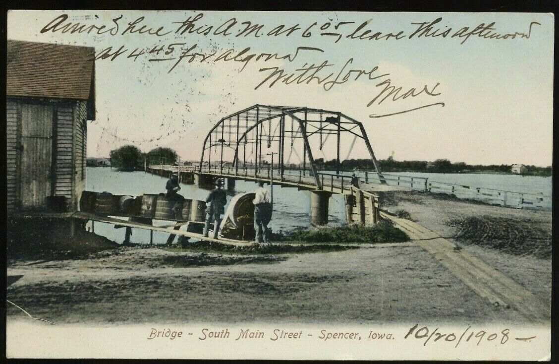
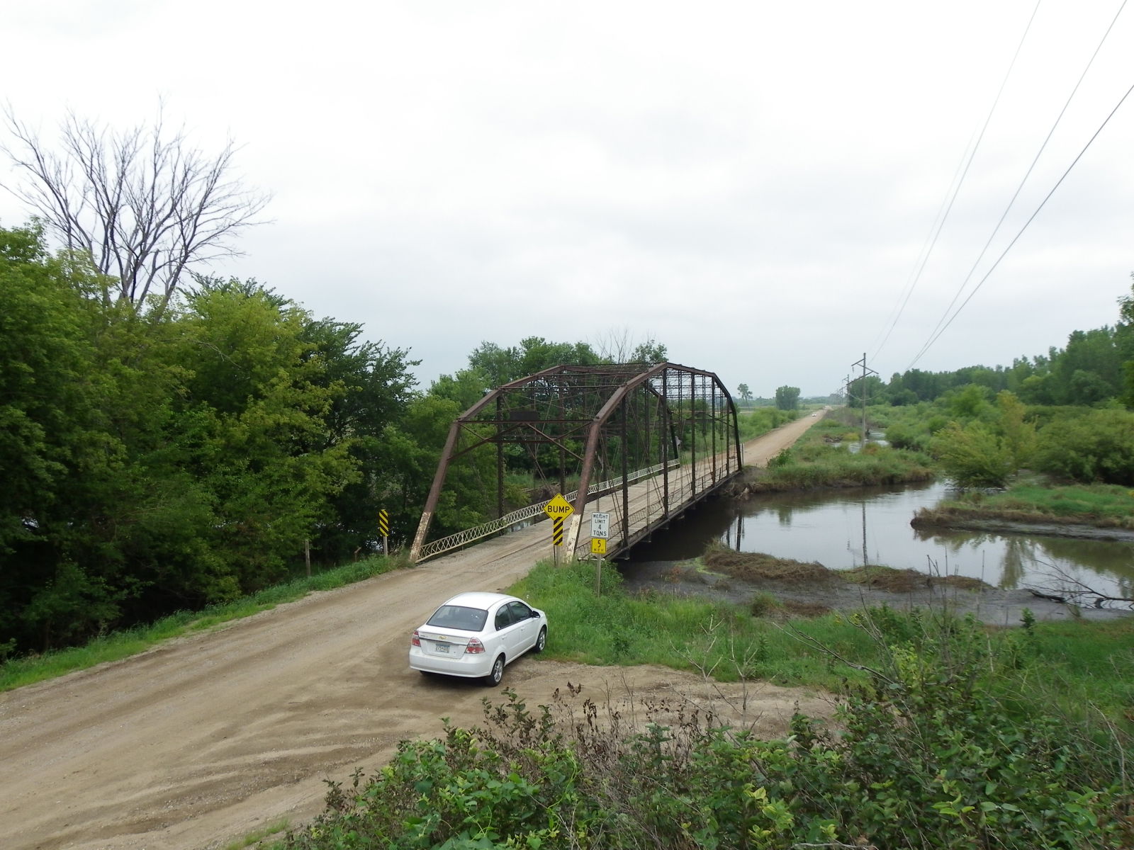
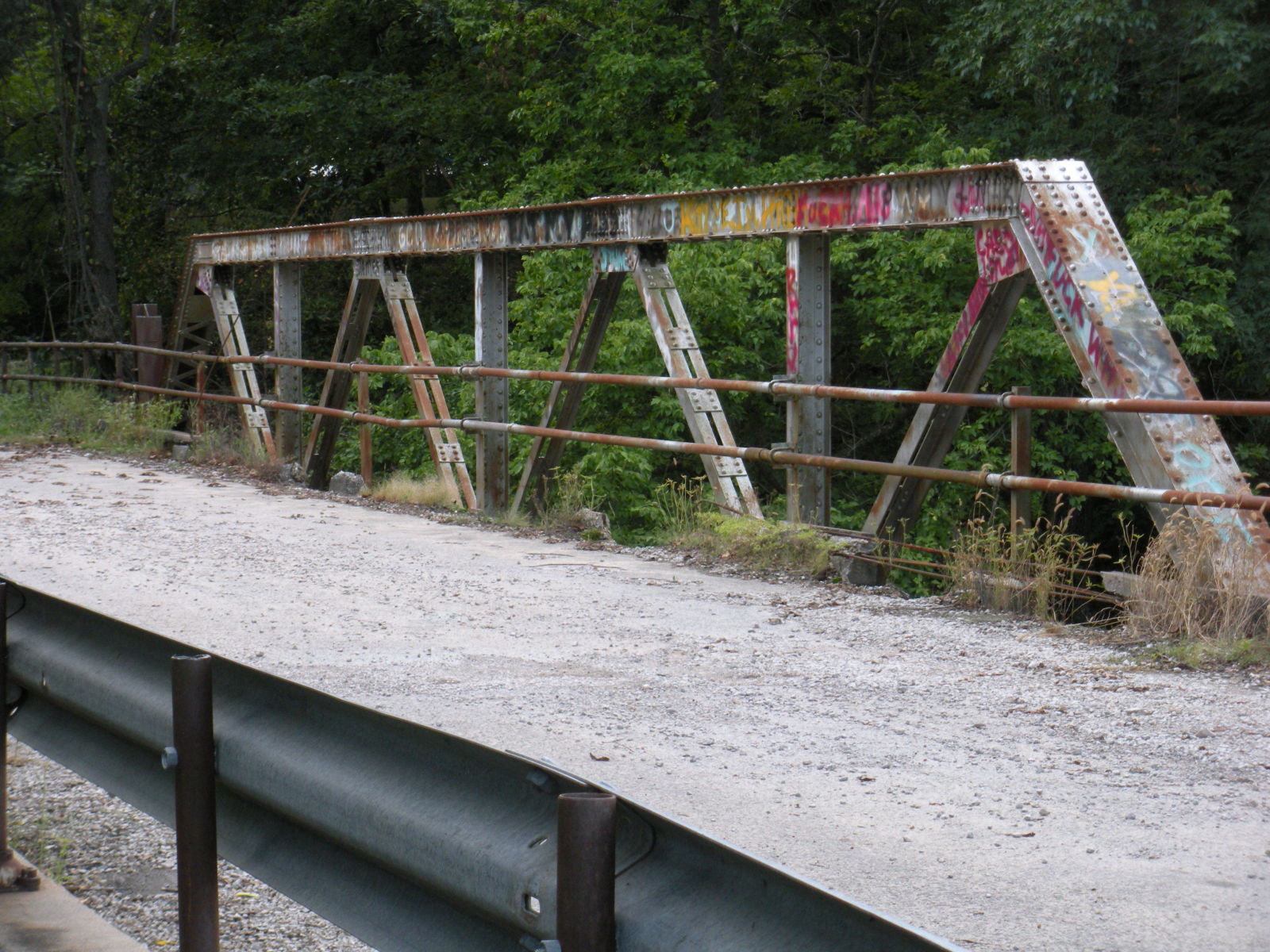
Sticking with the series on the Great Flood of 2024, we have this postcard and the first crossing located at present-day Grand Avenue in Spencer. The beauty behind this is the fact that the through truss bridge in this picture is still in use but at its present-day location. This postcard is of the first span of the Grand Avenue Bridge. It featured two through truss spans plus a long wooden trestle bridge in between the truss spans. Records indicated that the bridge was constructed in 1889. Most likely it was with Pratt through truss spans with Town Lattice portal bracings crossing both the Little Sioux and the tributary running alongside it. The span over the Little Sioux was replaced in 1901 with the Pennsylvania through truss bridge with A-frame portal bracings, as seen in this postcard. Clinton Bridge and Iron Works Company was awarded the contract for the replacement span. Because of the increase in the volume of traffic, the entire crossing was replaced with the five-span concrete arch bridge in 1917, which lasted until 2006. The truss bridge itself was relocated to the north of Spencer, where it carried 210th Avenue. The structure has since been closed to traffic but remains in its original form as you can see from my 2011 photo:
The bridge has survived several flooding incidences, including the last ones in 1993 and again in 2011. As the river recedes from its record high of 21.4 feet set on June 23rd, the bridge has survived another flood event, according to the locals- still in tact but muddied up given its proximity to the river, wildlife area and the adjacent gravel pit. The Pennsylvania truss bridge has proven to be a reslient truss type to resist such weather extremities, which makes for reconsideration about reintroducing the truss bridge as an alternative for constructing new bridges for highways and streets. But there is the question of whether the bridge is better off at a different location to be reused as a pedestrian crossing, built on higher land.
That would require some research as well as interest. With this bridge having a history that ties in with Spencer’s, it worth a shot giving Rusty a new life.
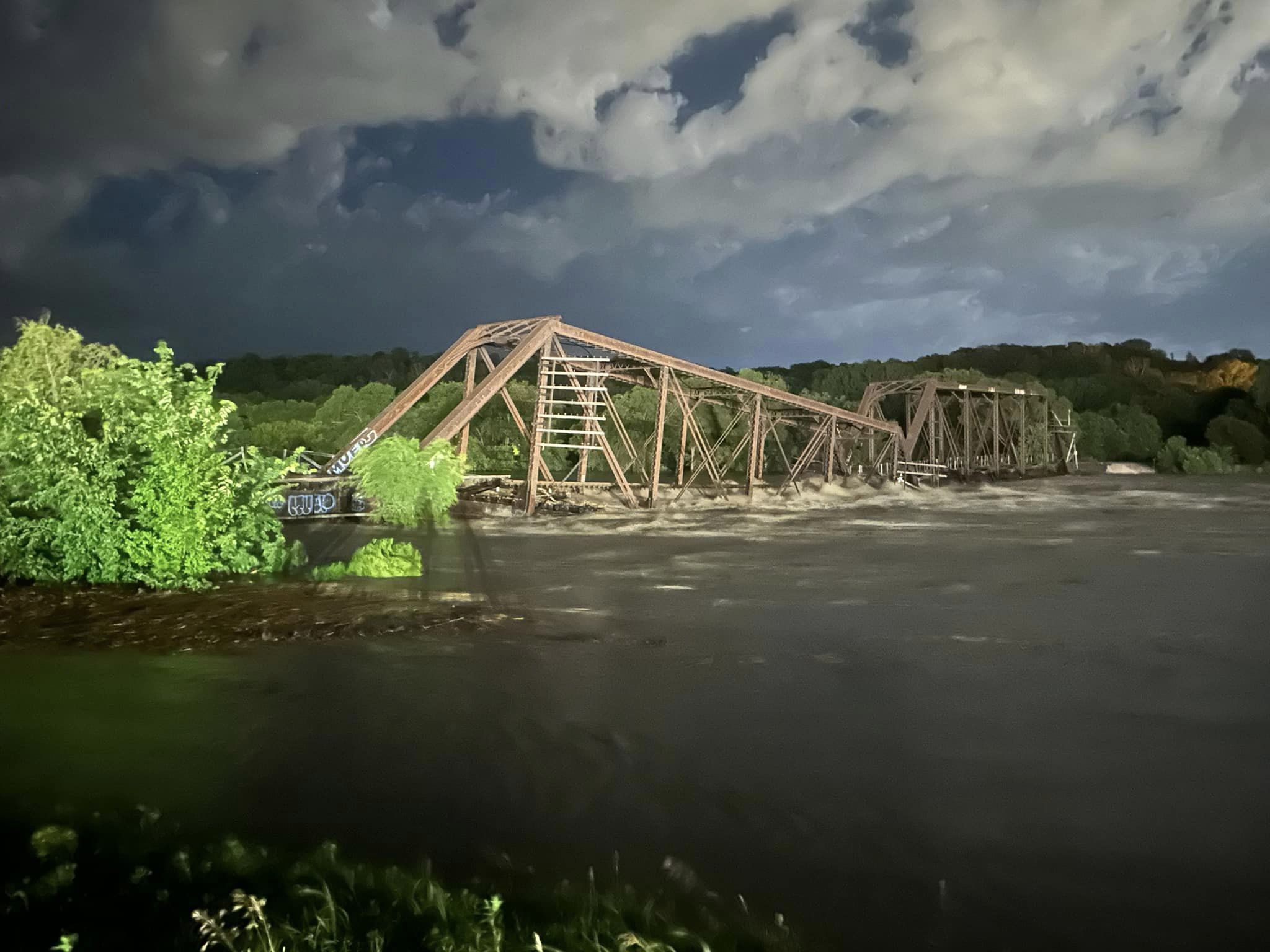
Photo by Cole Jendreczek, taken shortly after its collapse
This bridge has been the centerpiece of the Great Flood of 2024 to date and is one that serves as a bitter sample taste for what is yet to come as floodwaters make its way south and potentially cut the States in half, like it happened in 1993. In fact the city where this bridge is located, together with Spencer, is an example of what will happen in the coming weeks and months as this will be the summer to forget, but will be considered unforgettable in the history books.
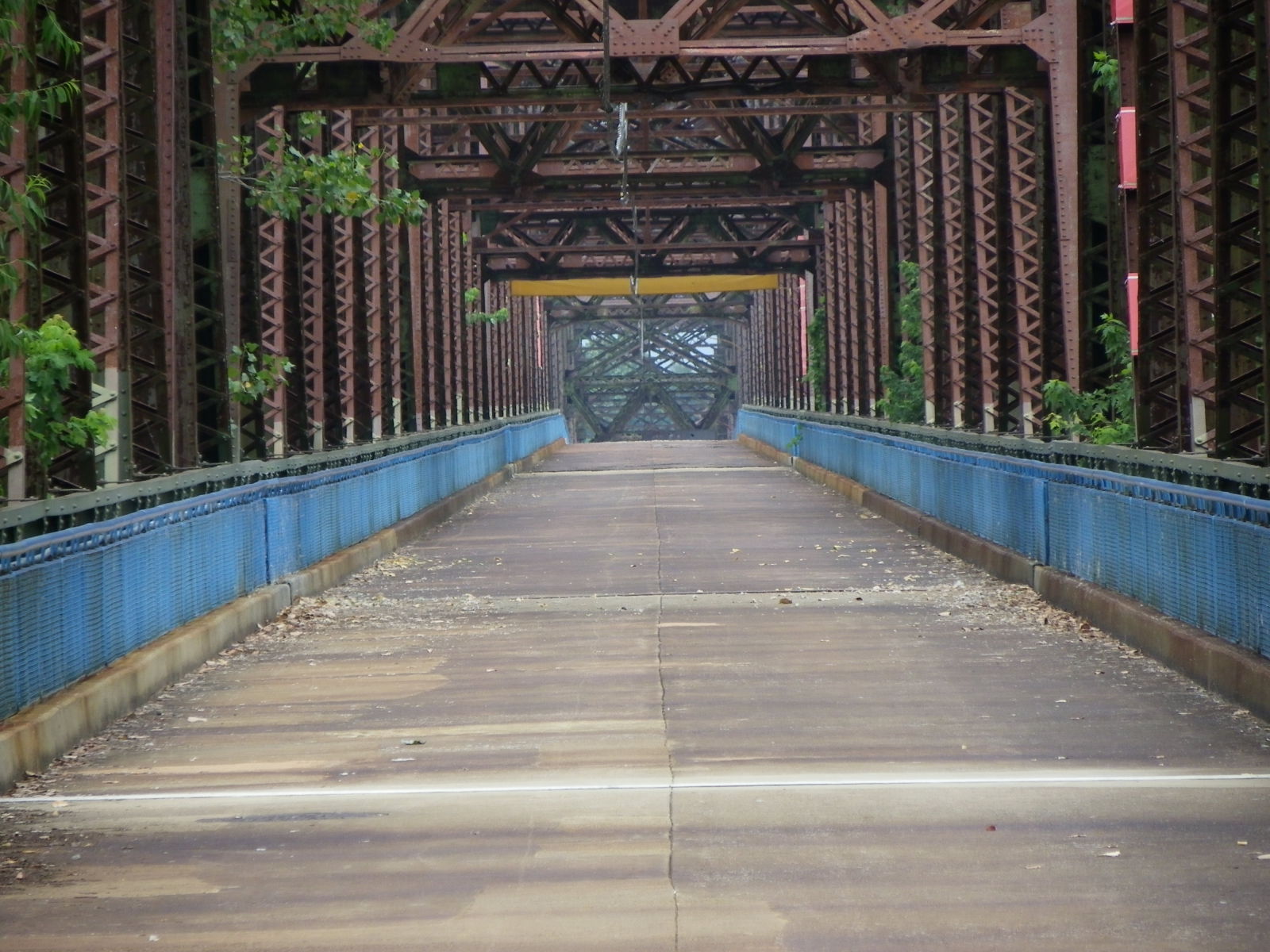
The North Sioux City Railroad Bridge is a two-span Pratt through truss bridge with steel girder approaches. Spanning the Big Sioux River at the Iowa-South Dakota border, this bridge was one of the last structures built by the Lassig Bridge and Iron Works Company of Detroit, Michigan in 1900 but at its original location in Cedar Rapids. In 1901, it became one of 28 bridge companies that merged to become the American Bridge Company as part of the deal by JP Morgan to purchase the assets from Andrew Carnegie, who later used his fortune to construct numerous libraries and places of fine arts, including Carnegie Hall. American Bridge Company still operates from its headquarters in Chicago to this day.
In 1905, the truss spans were relocated to its present-day site. As part of the plan to widen the river, American Bridge added girder spans on each end of the bridge in 1930. The bridge had a total length of 450 feet, of which each truss span had a length of 150 feet. The structure is currently owned by Burlington Northern Santa fe Railways (BNSF) and it serves a line connecting Sioux City with Aberdeen, via Hawarden and Sioux Falls.
In the wee morning hours of June 24th, floodwaters undermined the center pier holding the two trusses intact, causing one of them to collapse into the river. A facebook video reveals how the event happened ina matter of seconds:
At the present time, the collapsed span is still hanging on, yet the pressure from the floodwaters has caused that span to drift outwards, raising fears that it could break off and sink into the river. At the same time, the instability of the center pier is causing the standing span to sink. Already reports of the screeching and popping sounds of metal were made by local residents nearby and it’s a matter of time before the entire structure goes down into the river, especially as the Big Sioux River starts to recede after setting a record at 44.98 feet on the day of the bridge’s demise, smashing the record set in 1965 at 37 feet.
Regardless of what happens, the bridge will most likely be removed by BNSF as the railroad agency has been all out in replacing historic structures on its tracks because of its age and the increase in rail traffic. Whether or not it will be replaced remains open, as John Marvig mentioned in 2017, the route had been seeing three trains crossing the bridge per day on average. As the route has been detoured, it may be possible that BNSF will simply abandon the route and focus on more profitable routes. But because of damages to the tracks and other crossings, it may have to dig deeper into its financial treasure box to finance the rebuilding. If that happens, there may be a shining light on the future of the Bismarck-Mandan Railroad Bridge, the three-span through truss bridge that is being replaced. That project is expected to be delayed, buying time for a preservation group wanting to save the bridge to regroup and possibly take the railroad giant to the US Supreme Court in an attempt to halt the project or allow for two bridges to cross. But that will be a story for another time.
*********
If you have some photos and/or information of the bridges affected by the Great Flood of 2024, feel free to contact Jason Smith at the Chronicles, using the contact form here. They will then be showcased with some information that will follow on that.
For those who are traveling in the States this summer and happen to be in the central part of the country, please take extra precautionary steps to ensure you are out of harms way. Avoid areas that are underwater or affected by flooding. Obey traffic signs and do not go around barricades blocking roads. Laws save lives.
As far as swimming is concerned, consider indoor pools and waterparks as alternatives for many lakes affected by the Great Flood have been contaminated with bacteria and other chemicals from the runoffs that are considered harmful to humans as well as pets. Much of it can be found on the beaches. It normally takes 6 to 9 months for it to break down and for the water to be safe again for swimming. Please pay attention to the local department of natural resources and their advisories on swimming and boating before embarking.
Check your lodging possibilities and replan if necessary. If you are in the area affected by the floods, it had better be for helping residents (including sandbagging and clean-up) and not for disaster tourism. Put the people first before the phone and no fear mongering in social media. Take extra care of yourself and your loved ones.
************
Not just the bridges matter, but your community matters the most. ❤
Century Old Structure once connected Vancouver with Richmond.
VANCOUVER, CANADA- Investigation is still ongoing to determine what caused a fire to destroy a more than century old bridge and an adjacent warehouse. The fire happened on Thursday at the Marpole Bridge, a multiple span wooden trestle bridge with a steel girder swing span that spanned the Fraser River connecting Vancouver with Richmond in the Province of British Columbia. The bridge was built in 1902 by Canadian Pacific Railways and was once an electrified railway providing passenger service from 1921 until 1958. It was a key railroad crossing to Lulu Island and had served freight traffic until its abandonment in 2006.
On Thursday night, fire broke out at a nearby warehouse, which eventually spread to the rail trestle. Black smoke rose from the fire, hindering traffic on the neighboring Oak Street Bridge, forcing its closure. It could be seen from the metropolitan area. Because chemicals were used to protect the wood, it took over half a day to extinguish the blaze and still some parts reignited during all of Friday and Saturday. A summary and video of the fire, courtesy of CTV, shows the extent of the fire. The fire degraded the air quality prompting an air quality alert for much of Thursday and into Saturday.
Once the blaze is completely out, work will begin shortly to remove the remains of the trestle and any adjacent debris from the river, before boat traffic can reopen again. The structure is considered a total loss. Fortunately, there were no casualties, but as it is rare that a fire could happen on a wooden trestle, combined with the fact that the structure and the railline had been vandalized in the past, which included a fire at the site in 2014, arson cannot be ruled out at this time.
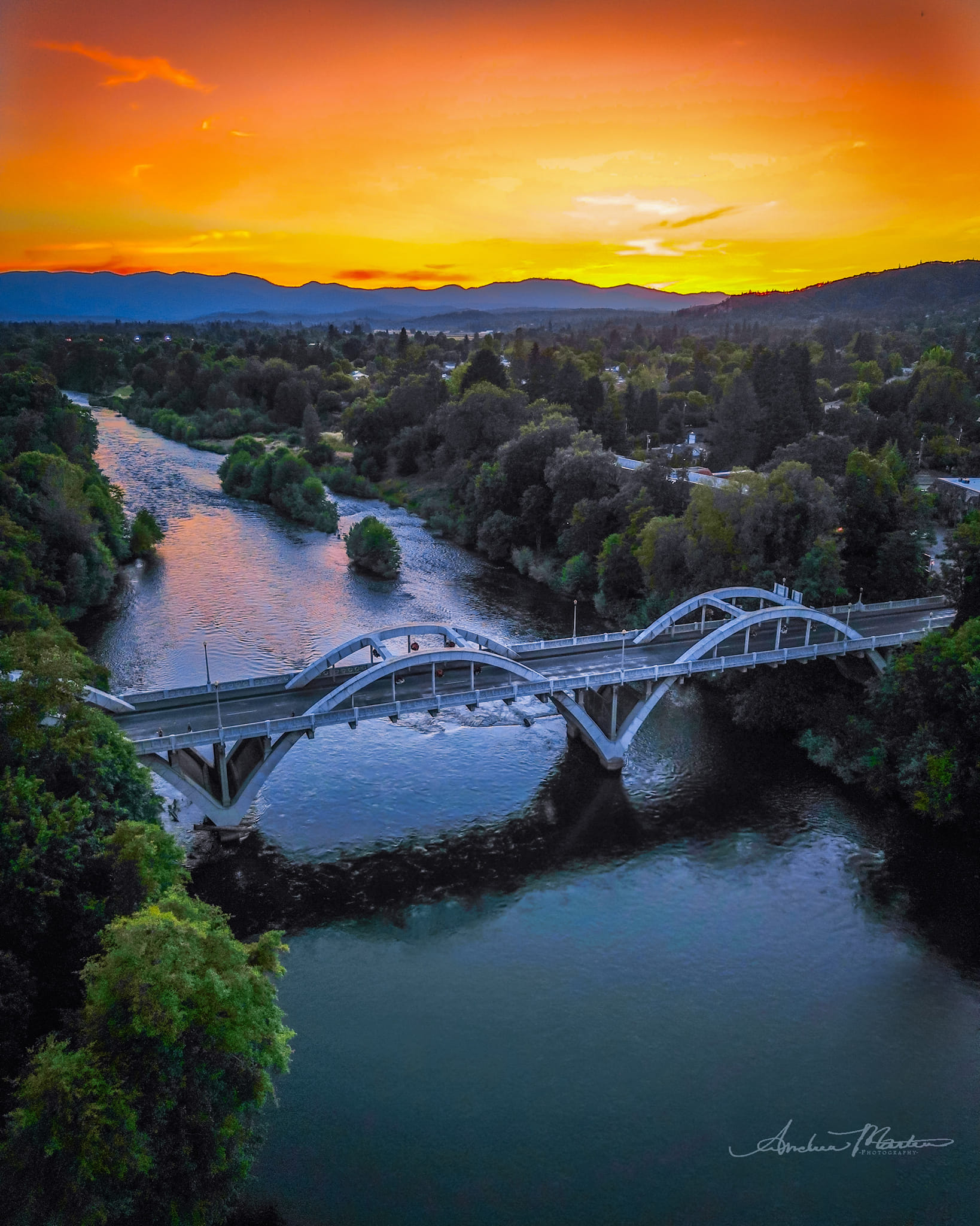
Andrew Martin presented this unique piece of photo artwork recently and because of that, it’s being featured here in this week’s Pic feature. It’s a dronage photo of a three-span Marsh Rainbow Arch Bridge that was taken at sundown near the city of Grants Pass, in Josephine County, Oregon. Some criticized it as a doctored piece. But with the advancement of technology and digital photography, the shot looks as real as it gets- unaltered and natural looking.
The bridge featured here is the Caveman Bridge. It was one of dozens of bridges built by engineer Conde McCollough, who left his mark spanning over 40 years. He helped design over 600 bridges-most of them located in Oregon and Washington state plus along the Pacific Coast Highway. His signature was the architectural details that were designed on the bridge, such as Gothic spires, art deco obelisks, and Romanesque arches incorporated into the bridges. He was one of the main disciples of the Iowa School of Bridge Builders, which included George E. King, the Carpenter Family (Edwin, Hamilton and James), Wickes Family, N.M. Stark and McCollough’s mentor and inventor of the Marsh Arch, James B. Marsh. McCollough worked for Marsh for one year before moving to the highway agency (later known as Iowa DOT). In 1916, he moved to Oregon where he was a bridge designer and teacher of civil engineering until his death in 1946.
The Caveman Bridge is an example of McCollough’s signature piece, combined with the design that he used based on Marsh’s invention. The structure was built in 1931 and is the third structure built at this location over Rogue River. The first one was constructed in 1886 and featured two Pratt through truss spans. It was followed by another through truss span built with a trapezoidal upper chord in 1890. Because of the increase in traffic, the city turned to McCollough to construct the three-span Marsh through arch design. The structure has maintained its integrity and aesthetic value ever since, only having been rehabilitated with an addition of a sidewalk in 2018-19. At the same time, the historic Redwood sign was also restored to its former glory.
The bridge still serves traffic today; it carries southbound Hwy. 99 and 6th Street SE and can be found just 300 feet from its junction with US Hwy. 199. While there are recreational areas available to get a on-land photo of the bridge, the drone photo by Martin could not be resisted and is therefore our Pic of the Week. Nice photo and congratulations! 🙂
Josephine County has several other unique bridges one can see. Two of which are a must:
Postcard Friday pays tribute to all the men and fathers out there this week. Yesterday was Father’s Day here in Germany, but the informal term for that day is Männertag. And in tradition, men hang out with friends, enjoying a good beer, but also performing stunts and causing trouble. 😉 This postcard of a bridge spanning an arm of the River Rhine near Rhinefall, Switzerland represents a place of gathering, but also a place where one could (but should not) perform a dare of any sorts. If you can identify the dare one should not do, then you wiser than you think. If you can spread the word to others on not doing that, then you are kinder and a more loving person than you think.
The bridge itself appears to be a Howe truss bridge with riveted connections, whose build date goes back to the early 1900s. The structure is more likely gone due to age, but it did provide a splendid view of the river and the mountains nearby.
For more on why Father’s Day is always celebrated on Thursdays in Germany and not on Sundays like in the States, click on the window below:
NONE OF THE CITIES: The bridge is located in Wilhelmshaven in Lower Saxony!
The bridge in the postcard is the Kaiser Wilhelm Bridge, spanning the harbor in WIlhelmshaven. It was designed by Anton Rieppel and built by the German construction firm MAN in Gustavsburg (near Mainz) in 1905-07. It was one of the first swing bridges in the country where both spans swung open to allow ships to pass. The double-span swing bridge was employed in many parts of northern Germany spanning canals and harbors between 1880 and 1960, including one built by Friedrich Voss in 1913, the same time as when he built the famous Rendsburg High Bridge for rail and traffic. The Kaiser Wilhelm Bridge is the last structure of its kind in service today and has been recognized as a technical monument.
And while we’re on the same page regarding the Rendsburg High Bridge, a fire broke out at the bridge on Monday shutting down rail traffic. Details in the article here:
We are pleased to announce that the damage was minimal and repairs were undertaken right away before reopening the bridge a day later. Information via link below:
Photos taken by Erica Parriot, used with permission
This is the first of two posts featuring bridges by fellow pontist Erica Parriot, who not only has her own Instagram page with a focus on bridges in the NE part of the US, but she has launched her own website recently that may end up becoming a counterpart to the US bridge websites that exist, namely bridgehunter.com, HistoricBridges.org and even Bridgemapper.
When I found this bridge on her page, I found it unique. The Hancock Bridge is a two-span, polygonal Warren through truss bridge that spans the West Branch Delaware River at the border between New York State and Pennsylvania. The structure was built by the American Bridge Company in 1936-37, and according to the website, the bridge was constructed using standardized truss design that was developed by the present-day New York State Dept. of Transportation. The bridge is unique because of its unique design that was used during the time of standardized trusses, the design that is rare to see nowadays, as truss bridges are being replaced with modern structures. It was built during the time of the Great Depression and is possible that it was part of the Works Progress Administration program initiated by President Franklin D. Roosevelt, who was also a New Yorker.
For its age, the bridge is in decent condition having received a restoration special in 2004. The structure is currently eligible for the National Register of Historic Places. It’s one of several historic bridges in New York that was photographed by Parriot that you will find on the pages, and especially one of many that should be visited while in the state; New York belongs in the top ten of states in the US that has a high number of bridges that are 60+ years old, most of them are unique because of their histories and unique designs and are therefore eligible for the National Register. Because its unique value, it’s one of the best kept secrets that are worth a visit, in my humble opinion. 🙂
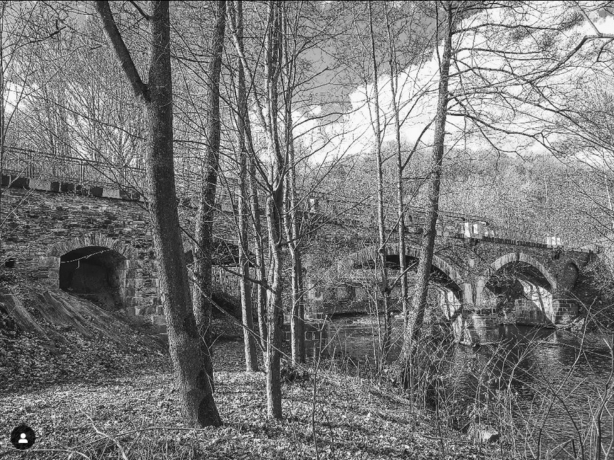
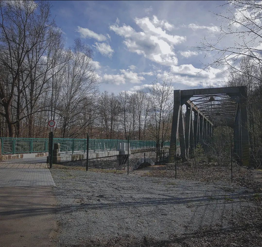
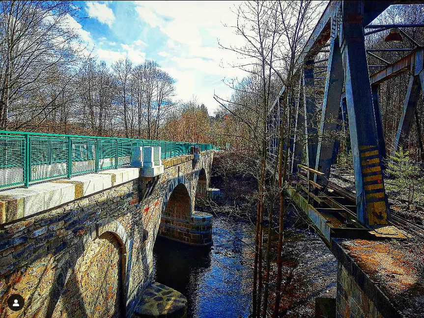
Since the end of last year, one of the oldest bridges spanning the Zwickau Mulde River has reopened to traffic. And with that, a safer alternative for cyclists to go instead of using the road to Hartenstein, which is laden with curves, rock slide barriers and vehicles, especially trucks. The Stone Arch Bridge in Bad Schlema is the only bridge along the river with a skewed span. Built in 1859, the three-span stone arch bridge used to carry rail traffic to the nearest factories located on both sides of the river. A through truss bridge was later added in the 1970s when the bridge no longer accommodated heavier loads. The bridge sat abandoned for almost five decades before an initiative was started to restore the bridge and shift the bike trail away from the highway. The project was launched in 2017 and took six years to complete, costing over a million Euros. In October of last year, the crossing opened to cyclists and pedestrians alike. The Mulde and Ore Mountain Bike Trails now use this bridge as it passes through Aue-Schlema en route to Zwickau to the north and Carlsfeld and the Vogtland to the south and west.
I had an opportunity to visit the newly restored bridge recently and my first impression was a big WOW! The bridge provides a grand view of the mountains to the south and northeast, yet it serves as a living exhibit for the truss bridge running alongside it, as one can see it up close like in the picture above and here:
Whether or not it will remain like this remains open. Plans are in the making to remove the truss span although when that will happen remains unknown. The structure has seen better days because of the rust, yet just having it there side by side would give it a historic status as a monument that contributed to the region’s storied industrial history, not to mention a great opportunity for photos of the two structures if you are a fan of bridges, photography and history.
Whether or not the locals agree with it I don’t know. But leaving it alone as is is worth a suggestion, especially now as the restored arch bridge is back in business after decades of being out of use. 😊🚵
The best bridge finds and the most beautiful are the ones you find in the places you at least expect them to be. This Mystery Bridge find happens to fit perfectly.
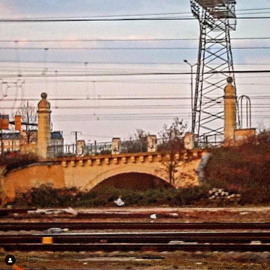
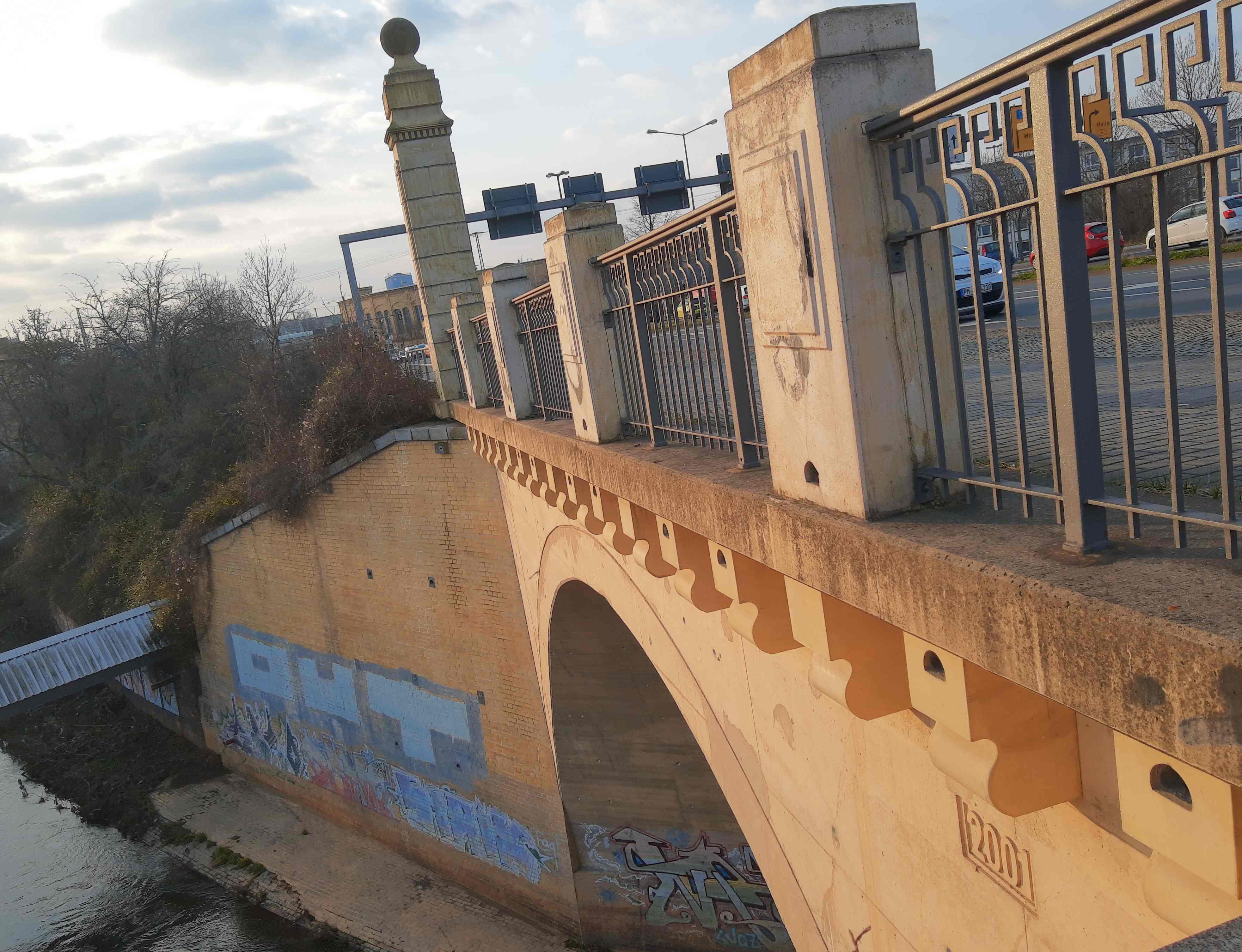
This single-span combination concrete and stone arch bridge is located just 400 meters east of Leipzig Central Railway Station, around the corner from the Brandenburger Brücke which spans the Leipzig -Dresden Rail Line. It crosses the Parthe, a small river that runs through the northern part of the city before emptying into the River White Elster. The bridge is characterized by its ornamental, monumental-shaped columns with a globe finial on top, located in each corner of the bridge itself.
On the arches, there’s the construction date of 2001, yet one has to assume that was the date it was widened and renovated as it coincided with the rehabilitation of the Brandenburger Brücke, which included a twin span built to accommodate traffic going to the city. The rehabilitation of the 1910 arch bridge and the construction of the coupler span were completed in 2003. Both the railroad crossing pairs and this bridge over the Parthe. carry Highways 2 & 87 going to Halle (Saale) and Torgau, yet they are only 70 meters from each other and just around the corner.
While the build date on the Parthe is 2001, it is more than likely that the bridge was built more than a century ago, which leads to the question of the structure’s origin: when was it originally built and by whom? Who built the arch span and who was behind the design of the columns?
The bridge is difficult to photograph as it is located right next to the railroad tracks and entering it is not allowed. The best photo of the bridge is best taken from the train, as you saw in the second picture, yet the shot needs to be quick, like a drive-by shooting. The details of the bridge are possible as there are sidewalks on both sides of the bridge.
What do you know about this bridge? Feel free to comment in the section below or use the contact details in the BHC and feel free to provide some information on it. Remember: Your bridge matters. ❤️🌉
You can find photos of the Brandenburger Brücke on the Chronicles’ Instagram page, which includes some interesting facts about its history.
In 2011 at the Historic Bridge Convention in Missouri, I had a chance to meet Clark Vance in person and found him to be open-minded in many aspects, but having knowledge that is enriched for historic bridges, and other artefacts. Mr. Vance just recently retired from his position as high school teacher, but has been a key contributor of historic bridges for bridgehunter.com for as long as the website has existed, providing readers with photos and interesting facts on historic bridges, mainly in the Midwestern part of the US, centering around the states of Kansas and Missouri. Because of his contributions to historic bridges- as a photographer, historian and sometimes consultant- Mr. Vance won the Ammann Awards for Lifetime Achievement in 2018.
I had a chance to interview him recently about his interests in the topic and found some more interesting facts about him, how his interest in historic bridges first started and some words of advice for those who are working in the field of historic bridges, in terms of photography and preservation. This is what I learned from him, as you read the interview:
Tell us more about yourself in terms of professional and private life.
I recently retired from 11 years of teaching engineering, math, and software engineering to high school students. I previously worked in IT and automotive technology. I still enjoy working with and driving my (too many) cars and motorcycles. My wife is a psychologist in private practice and her daughter is a professor at an art and design school. I highly recommend being retired.
What got you interested in historic bridges?
My father was a civil engineer with the Kansas Highway Department in the late ‘40s before going to work as a structural engineer in private industry. He didn’t mind my gazillion “What’s that?” questions as a kid and actually had the knowledge to answer a lot of them, particularly about man made artifacts in the natural environment. My curiosity about infrastructure was rewarded with good explanations of whatever odd item caught my attention. Some of my best times as a kid were when he and I would visit road construction sites and he would answer all my questions then add information about things I hadn’t noticed.
You do mostly bridge photography, right? Or do you write or talk about them?
My main public activity surrounding bridges is as a contributor to BridgeHunter.com. I’ve enjoyed old maps as a way to see into the past and discover things that are unused and forgotten. My enjoyment of driving back roads and hiking fit with this, and BridgeHunter gave me an excuse to photograph the things I found. I don’t consider myself a bridge expert or historian and I try to avoid spending too much time talking with others about bridges lest they consider me odd(er).
Do you teach historic bridges in school? If so, how?
I didn’t get a chance to teach the second year class where we taught truss analysis, so my role as an educator was mostly as an informal consultant for the students working on entries to bridge building competitions. I taught an intro civil class where I got to cover infrastructure and of course I exposed my students to a lot of structural history using bridges. I hope they came to appreciate the significance of structures that their later instructors will possibly dismiss as obsolete.
What kind of historic bridges do you look for?
Although I enjoy simply documenting older existing structures, my greatest enjoyment comes from locating and documenting bridges that have been forgotten. Most of the time there is little left physically but I like to record the location and identify any visible remnants. Kansas City still has places where one can see the paths worn by the wagons heading out on the Santa Fe Trail. For whatever reason, I feel it’s important for people to remember the paths used in the past.
A historic bridge in your opinion is…….
Defining what constitutes an historic bridge is similar to identifying an historic car. Anything old enough is worth preserving, and the more important it was when new, the more significant when old. Even the plainest, cheapest Model T should not be scrapped if it’s possible to preserve it. A Cadillac V-16 is obviously more rare and more worthy of preservation. From the perspective of the people trying to use objects in the economy, is would be foolish and wasteful to try to run a fleet of Model T taxis and it’s equally foolish to expect a tall, narrow pony truss to carry a combine or loaded grain trailer. It’s fun to drive old cars across the Chain of Rocks bridge but trying to keep it as part of the interstate system makes no sense.
Chain of Rocks Bridge. Photo taken by Jason Smith in 2011
What is your favorite historic bridge?
Picking favorites is difficult. Friends and I would walk out on the Chain of Rocks bridge not long after it closed. I haven’t been back since it got cleaned up but I imagine it’s still pretty spectacular. As a kid my family would visit relatives in southeast Kansas and I have a long standing love for the Marsh arches. I also enjoyed driving the old Flagler railroad bridges linking the Florida Keys back in the ‘70s.
What historic bridge(s) do you miss the most?
Probably the bridges I miss most are: The Chouteau Bridge in KC. Totally obsolete and awful for trucks and cars alike, it was nonetheless an important bridge when built and quite impressive an an old, still functioning work. The ASB automobile lanes were narrow and had a reputation for fatal accidents where the lanes split to go around the trusses. For better or worse, one could have a close look at the structure and mechanism while driving by. More generally, I miss the many through trusses that were everywhere when I began traveling and which have almost all been replaced by much more efficient boring bridges guaranteed to keep concrete plants busy repairing and replacing them.
What words of advice do you have for the following:
Photographing Historic Bridges: Get the big picture and the little details. Show the setting and what one would see driving by or passing under. Also, catch the details that can help identify the builder, date, and other parts of the history.
Teaching about Historic Bridges: I wish I had more knowledge about this. I found that I could engage students by providing some of the history behind modern concepts. Bridges played an important role in the development of engineering as a field, so I tried to cover bridge technology in discussions about changes brought about by developments in material science, structural analysis methods, etc.
Preserving Historic Bridges: Two things strike me as most important, public support and technical skills. Right now old bridges are in a place similar to steam locomotives in the ‘50s. They are being phased out and replaced by products deemed superior by policy makers. I don’t think there is much hope of their remaining in common use. The focus needs to be on finding ways to save them from being scrapped and preserving the knowledge needed to put them back in limited use when more of the public has the desire to experience the old technology. Each one lost will make the remaining ones more valuable and more likely to be saved.
Thank you for your time, Clark and wishing you all the best in your endeavors. J
The next question is who will win the now rebranded Bridgehunter Awards in the category Lifetime Achievement? If you haven’t voted yet, click here and you will be directed to the ballot. Deadline is January 10th and the winner will be announced two days later.
Note: Photos posted but not cited here are all courtesy of Clark Vance.
Waddell Truss Bridge at Volga State Preserve. Photo taken in August 2011
.
Joint Article with Sister Column:
In connection with Files’ series on In School in Germany. More on the series can be found here.
History- a subject that goes beyond borders and looks at things that we never knew about, getting us to think about them, putting them in the context of our own lives and the environment we are living in. It goes beyond the borders of geography and how the countries were developed. It goes beyond arena of sports events and looks at the development of each kind and how the men and women contributed to it. It digs deeper into how the country was mapped out in terms of landscape, networks of infrastructure and the social aspects which led to revolution and redesign by reformists and those who wanted to make their place better than before. In other words, one has to dig deeper to find the truth and challenge what had been written in the past but was now rebuked because of new evidence.
In school, especially on the secondary level, history is a must, and it is important that students know about the history of their country and the rest of the world for two reasons:
1. To help them become acquainted with their own region and country and discover who they are and where they came from and
2. To encourage them to find out more about themselves and where they live, by looking and exploiting the aspects that are seldom mentioned.
As there are certain requirements written by law and because of certain time constraints, only a peck of the history that exists is even taught in the schools, and when it is taught, it is with the traditional social form of teaching: the book and frontal teaching (German: Frontal Unterricht). It is not surprising that the interest in history among youngsters up to 18 is near the bottom of the food chain, in both countries- more so in the US than in Germany because of the strive of educators to have the students achieve high results in the international tests for math, reading and sciences. But as we see in the PISA studies, and which will be discussed in the Files’ article about Frontal Teaching, sometimes student involvement and allowing them to discover something new can encourage a positive education result, even better than the recent studies.
But even with these constraints, the teacher can make some space for some new things that cannot be found in books themselves- at least not yet, that is. And when students are encouraged to do some work on their own, whether it is analysing a text and writing a review about it or presenting about it, then they will benefit from it in a way that they can add the knowledge to what was taught in the past and have fun doing it. This is where the topic of Industrialization and Infrastructure enters the picture.
During my internship at a Gymnasium (EN: High School) in Germany, I had an opportunity to dig deeper into the history of the development of Germany in the 1800s by looking at aspects like the creation of democracy, Otto von Bismarck’s creation of the German state in 1871 and how Germany became a super power and remained so until the end of World War I. At the present time the students are talking about Germany, Europe and the age of industrialization between 1871 and 1914, where several aspects, such as imperialism, socialism, worker’s union and environment are being introduced. Even the expansion of the transportation infrastructure and the landscape made of steel will be mentioned. Believe it or not, this is the topic the author of the Chronicles and Files is about to do.
Talking about the infrastructure and comparing it between Germany and the US does produce their similarities in terms of inventions and the development of materials for the construction of buildings, railroads and bridges, yet how does a teacher present these aspects to the students without boring them. Let’s look at the topic of bridges, for example. There are two different arguments for and against presenting this topic. The contra part would be the simple fact that a bridge is a bridge, crossing a ravine connecting point A and point B. If it fails or is too old, then it is replaced. The pro part to this topic feature the arguments about unique bridge designs, bridge builders that were common, including those who immigrated to the States from Germany, like Ralph Mojeski, Lawrence Johnson, Albert Fink, and Gustav Lindenthal, to name a few. Then there is the switch from iron to steel mainly because of the Great Chicago Fire of 1871, and lastly the consolidation of 28 bridge builders into the American Bridge Company in 1901 and its competition from other bridge builders in the west, as well as outside the country.
Nathan Holth once presented this topic as a whole during his time as a student teacher (his PPT presentation can be seen here). Some of the unique features, include the builder’s plaque, portal bracing of the truss bridge and ornamental features can enable historians to determine how the development of bridges came about in the US between 1871 and 1914. As I will be the second pontist to present this in a couple weeks time, the topic will be on a wider scale as Germany and US have some similarities with regard to bridge construction. The difference is with regards to the fact that the German concentration seems to be more on canals and railways than with highways, like in the US. Also the full establishment of steel companies, like Thuyssen-Krupp before 1871 enabled Germany to expand the steel-building landscape, constructing bridges and high-rise buildings in large cities, like Berlin and Hamburg, in addition to its fleet of ships.
The question is if one wants to present bridge building in connection with the industrialization- be it in the US, Germany, Europe or when comparing between two countries, what aspects are important and should be presented to the students, keeping in mind that the topic is industrialization, and the time frame is betweenthe 1870s and 1914, the time of World War I? Which aspects should the students research on in their own spare time? And lastly how should it be taught in high school in comparison to college?
Put your comments here or on the Files’ or Chronicles’ facebook pages as to how you would approach an exotic topic like this, while keeping the topic of Industrialization in mind. I created a pocket guide to industrial history which includes bridge building as one of the aspects. You can click here to read about it.
This is a blog about my project of visiting every bridge over the Genesee River and what I learned about the history, structure, and natural surroundings of each bridge.