C.W. Gove of Windom, Minnesota

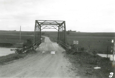
Petersburg Village Bridge
Petersburg Village Bridge in Petersburg (Jackson County), MN Photo taken by MnDOT in 1963

This article is in connection with the creation of the database for the Bridge Builder’s Directory in the Bridgehunter’s Chronicles’ wordpress page, which you can click here to view. More information is needed on this gentleman, who contributed a great deal in engineering southwestern Minnesota, including Jackson, Cottonwood and Murray Counties. If you have information that will help, the contact details are at the end of the article.

Charles Wallace Gove is a little known figure in the engineering business as his primary focus was building bridges, roads and ditches in southern Minnesota, in and around Cottonwood County  (where Windom is located). Little is known about the bridges he built except records  indicated he built two bridges in Jackson County (which are profiled at the end of this info  sheet) and an unknown number in his county. On the political level, he was a dedicated  farmer and political journalist who left his mark at the State Capitol with his plan that is still  being used today for commercial farming.

Born in 1863 in De Witt, Iowa, he and his brother Wade settled in Jackson County, Minnesota in 1886, where he farmed and taught in nearby Lakefield until his move to Cottonwood County in 1895, where he established his farmstead in Great Bend Twp. northwest of Windom.  From that time on until his death in 1936, Mr. Gove busied himself with the transportation sector, first as a surveyor until 1912 and then afterwards, as a county engineer. During his tenure as surveyor, he led the efforts in constructing ditches in Cottonwood, Nobles and Murray Counties and later on in parts of Jackson County, as flooding was rampant during that time, and farmers needed them to provide runoff for the excess waterflow.

It was also during that time that he led the bridge building effort in parts of Jackson County, as county officials were turning to local builders who were willing to construct bridges at an affordable price. While the bridges he built were not spectacular in design, his most worthy structures were the bridge near Rost as well as the second crossing at Petersburg, built in 1912 and 1915, respectively.  When he was not building bridges and maintaining the roads in Cottonwood County, he wrote various articles and essays for local and regional newspapers, including his most famous one, the Minnesota Plan. There, he advocated simpler farming techniques, which included constructing  deeper and systematic plowing before planting and ditches to provide water run-off.  His writings dealt with philosophical thoughts mixed with a bit of wit and humor that made the readers enjoy every paragraph. He was recognized by the state for his work at the time of his death. Charles Gove died on 29 August, 1936.

Rost Bridge
Rost Bridge. Photo take by MnDOT in 1948

The Bridges built by C.W. Gove:

Rost Bridge

Location:  Little Sioux River at 390th Avenue, 0.1 mile south of Interstate 90 in Rost Twp.

Type:  Steel stringer with steel railings (altered in the 1970s)

Dimensions: 32.3 feet long; 16.4 feet wide

Built in 1912, replaced in 2002

This bridge used to carry a key road to the unincorporated village of Rost, located 2 miles north of the bridge. The village had a couple trading businesses and a church, the latter of which still exists today. The contract was given to C.W. Gove to build this bridge on 8 July, 1912, which was completed by the end of that year. The road was cut off by the Interstate in 1973 and after 90 years in service, this bridge was replaced by a pair of culverts in 2002.


Petersburg Village Bridge

Location: West Fork Des Moines River on a local road in Petersburg

Type: Two-span Pratt pony truss with pinned connections and steel cylindrical piers

Dimensions: 171 feet long (2x 81-foot truss spans); 16 feet wide

Built in 1915 replacing an earlier structure; destroyed in the 1965 flooding during the construction of its replacement upstream. Replacement bridge opened in 1965

The Village Bridge was the longest bridge known to have been built by C.W. Gove. He was awarded a contract to build the structure for $3050 to replace the bridge built 30 years earlier, just after it was founded. The bridge was in service until the Flood of 1965, which destroyed the structure. It was also at that time that a construction worker at the new bridge, located one mile west of the old one, fell into the icy river and drowned. His body was recovered in June 1965, three months after the replacement bridge opened to traffic


Do you know of other bridges built by C.W. Gove or have some more knowledge about the Minnesota plan or his written work? Let’s hear about it. Contact Jason D. Smith at the Chronicles at flensburg.bridgehunter.av@googlemail.com and feel free to provide some additional information for this fact sheet about this unknown engineer who left a mark on the local level. The info will be added and/or modified  based on what comes in.


bhc-logo-newest1


Photos of the Rost and Petersburg Village Bridges are courtesy of MnDOT


Mystery Bridge Nr. 47: The Twin Bridges over the Des Moines River in Minnesota

Sherman Bridge northwest of Windom. Photos taken in 1962 by MnDOT


The next mystery bridge features two bridges and is part of the book project on the bridges along the Des Moines River (for more, click here). This one takes us to Cottonwood County, Minnesota, located north of Jackson County, where the author grew up, and a main throughfare that crosses the river three times in the same county, County Road 15. The road enters the county from neighboring Murray County at Talcot Lake and after crossing the third Des Moines River bridge, terminates at US Hwy. 71 north of the county seat Windom.

Two of the Des Moines River crossings are featured here because they are literally identical. Both bridges feature Pratt half-hip through truss designs, with M-frame portal bracings and V-lace endposts. They are both approximately 80 feet long, despite the fact that the difference in total length between the two are only 40 feet apart. Both were built before or around 1900 but the information is very sketchy- sometimes “suspect” because of questionable data. The only difference is the location of the two- one is next to a golf course just outside of Windom, the other is only four miles to the west after the river bends to flow southeasterly.  To be specific as far as what bridges the author is talking about, here is what we know about the two bridges:

Side view of the Sherman Bridge. Photo courtesy of MnDOT


Sherman Bridge :

Location: Des Moines River at the Golf Course, 0.3 miles west of County Road 13  at Sec. 21 Great Bend Twp.

Length: 141 feet total (main span: 80 feet)

Replaced: 1960? with a concrete slab bridge

Thompson Bridge Photo taken in 1962 by MnDOT


Thompson Bridge

Location: Des Moines River, 0.4 miles north of County Road 40 at Sec. 14/15 Springfield Township.

Length: 95 feet total (77 feet main span)

Replaced: 1963 with a wooden trestle bridge

Questions remain open regarding the history of the two bridges. First and foremost is the question of the date of construction and the bridge builder. Judging by the features of the two spans, they were most likely built by the same company at about the same time. Some possible bridge builders that did business in Cottonwood County include Raymond and Campbell of Council Bluffs, Iowa, Hennepin Bridge Company of Minneapolis and Joliet Bridge Company of Joliet, Illinois. Judging by the markings of three bridges built in neighboring Jackson County during the time frame between 1880 and 1905, they appear to be the work of Raymond and Campbell, for its agent, George C. Wise had conducted business in the region between 1880 and 1910, both under the auspices of R & C as well as an independent contractor. He had built at least a dozen bridges in Jackson County and most likely did business in Cottonwood County. Yet more evidence in the form of newspaper articles and other information would be needed to confirm this. Joliet Bridge most likely built the Dempsey Bridge, located five miles northwest of Windom over the Des Moines River, but more information is needed to determine if it built other bridges at that time. The same applies to Hennepin Bridge Company, one of many bridge companies operated by members of the Minneapolis School of Bridge Builders which featured the Hewett family, Commodore Jones and Alexander Bayne.

The other question deals with the replacement date for the two bridges- in particular, the Sherman Bridge. National Bridge Inventory database and even the history books have the bridge being replaced in 1960, yet according to records and photos provided by Minnesota Dept. of Transportation, the bridge was still standing as of 1962. This leads to the question of whether the Sherman and the Thompson were replaced at the same time and if so, when. While working on a book on the bridges in neighboring Jackson County, an error was found in the NBI and state historical society records indicating a through truss bridge in Jackson being built in 1930, when city records pin-pointed its construction date of 1907, built by Joliet. This means that in the case of the two bridges, further information will need to be found as to when they were constructed and when they were replaced, in order to update all records to reflect on their history.

This is where you come in. If you have any information on the history of the Sherman and Thompson Bridges including photos of their existence and even replacement, the author would be much greatful if he could use them for the book project. Please send them to Jason Smith at the Chronicles at: flensburg.bridgehunter.av@googlemail.com.  Any information on the two bridges will be useful to complete their history. It is very rare to have twin bridges sharing the same road with little knowledge. Yet through your help, you can solve their mystery.  Looking forward to the information that is forthcoming.

Thompson Bridge. Photo taken in the 1940s by MnDOT