BHC Pic of the Week Special: The Great Flood of 2024

Grand Avenue Bridge in Spencer. Photo taken by Eric Johannsen

One doesn’t think that Global Warming and its implications would affect us- until it reaches the front steps of our own homes. And that’s exactly what happened this past weekend in my hometown of Jackson, MN and the surrounding regions. In fact, we are at the start of what will be a repeat of the Great Flood of 1993 but with larger rammifications. At that time, the Missouri and Mississippi Rivers almost cut the United States in half with high water stretching as far north as Minneapolis and with a width of over 1000 miles wide. But that didn’t come without widespread destruction.

31 years later, we’re seeing deja vu all over again, thanks to massive rainfall that the regions of the Upper Midwest has been having recently. The Bridgehunter’s Chronicles will be doing a series special on the Great Flood of 2024 and its impacts on bridges, historic and also modern, to show the readers the extent of the damage. Other stories and updates on the Great Flood plus some author’s points based on his upcoming visit to the States this July will be found in the sister column, The Flensburg Files.

**********

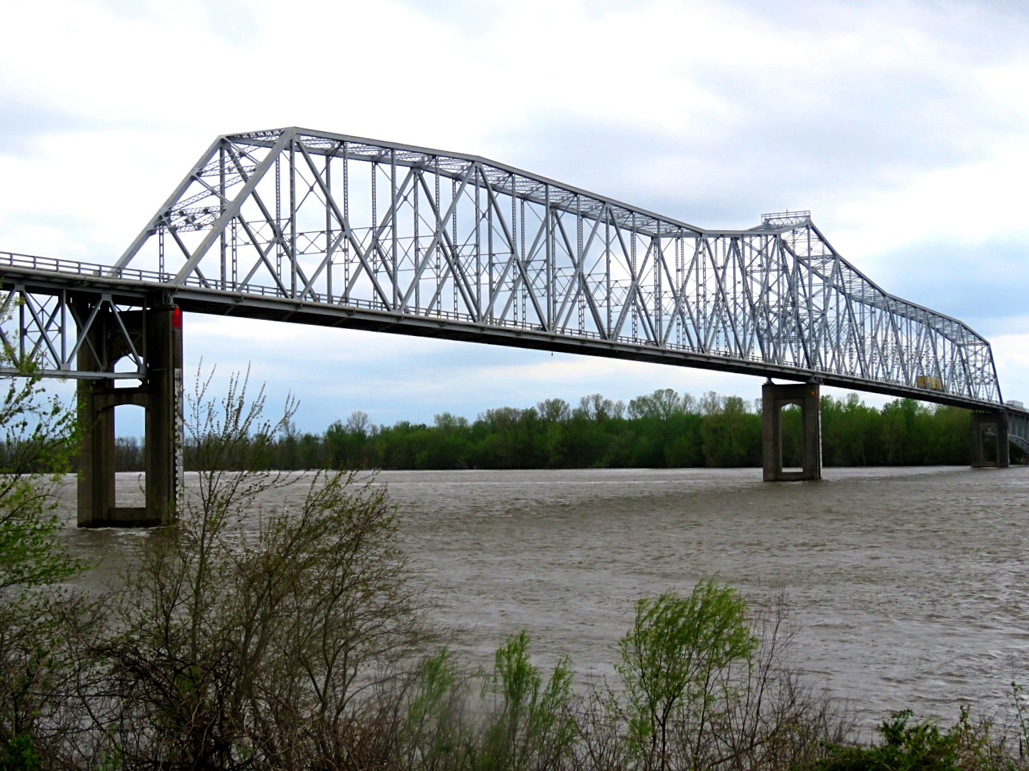
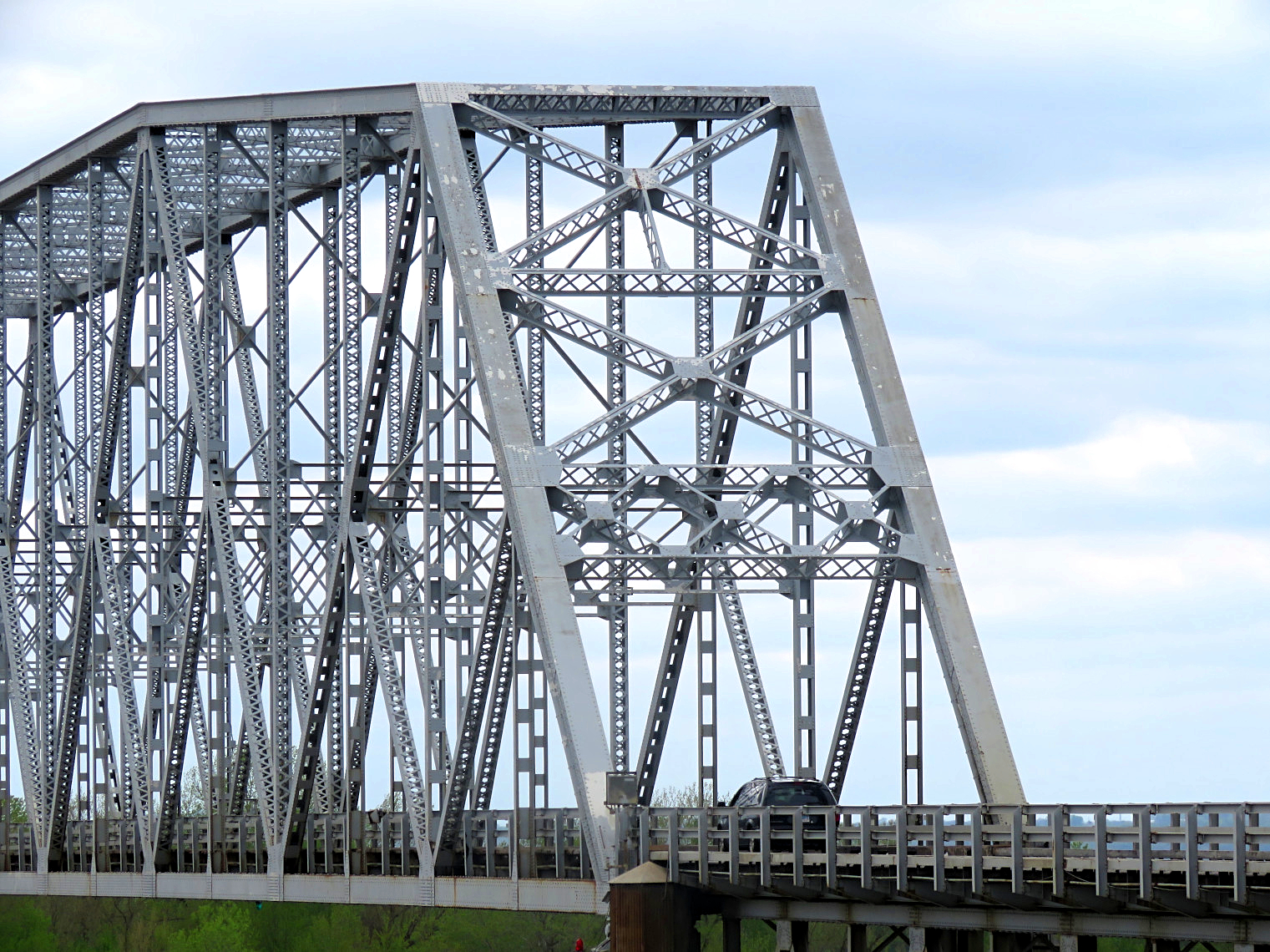
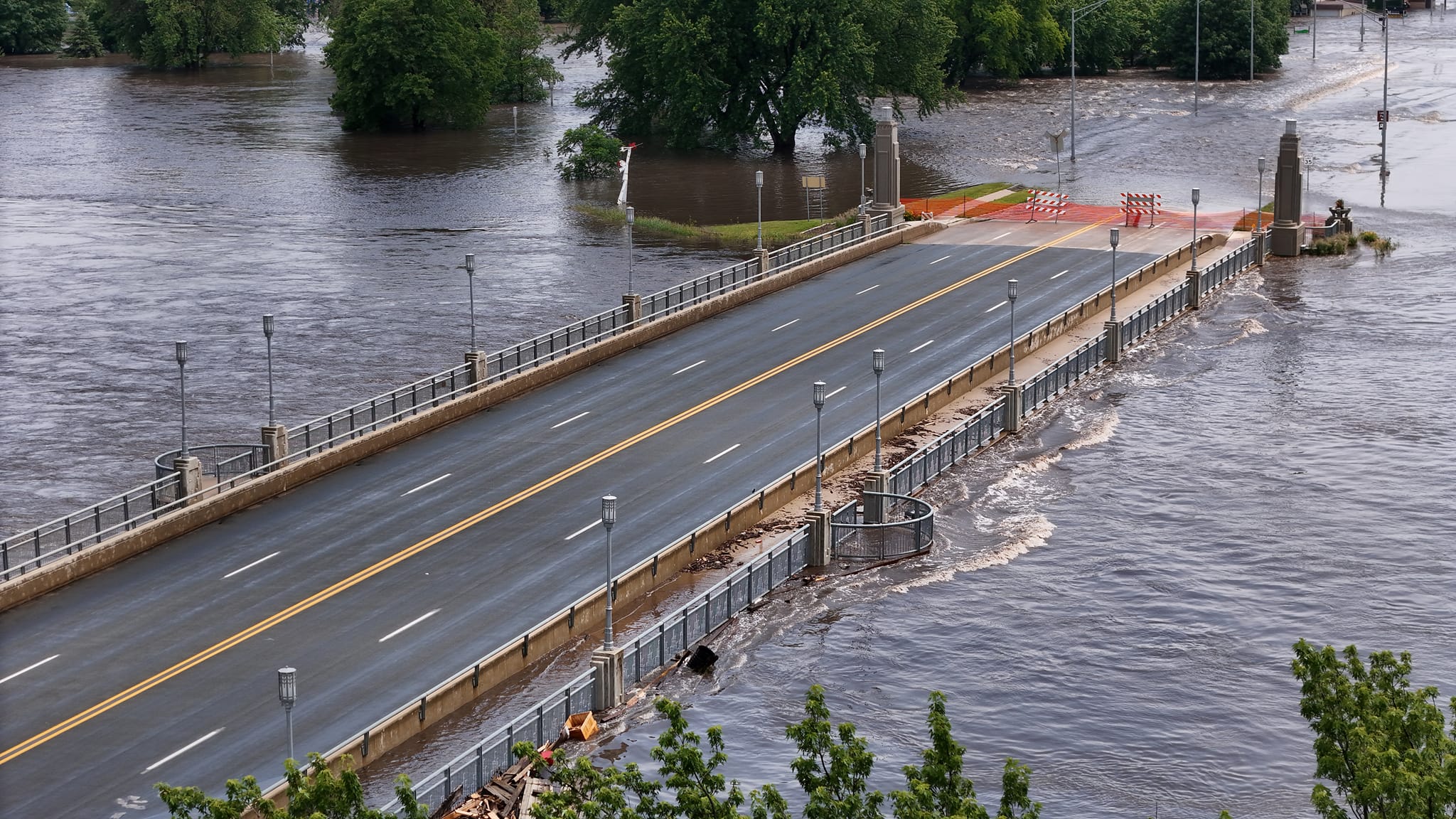
Our first Pic takes us to Spencer, Iowa and to the Grand Avenue Bridge spanning the Little Sioux River. The present-day structure was built in 2006 and is characterized by its art deco towers and unique street lighting to cover its plain deck girder design. It’s the third crossing at this site, for it replaced the five-span Luten arch constructed in 1915 by Thor Construction of Cedar Falls. Its first crossing was a Pennsylvania through truss bridge built by Clinton Bridge and Iron Works in 1901. That bridge was relocated to its present-day site on 210th Avenue north of Spencer and is named Old Rusty.

Eric Johannsen took this dronage shot of the bridge shortly before it crested Saturday afternoon. The city was one of the first to see its flood record smashed, for the river crested at 16.93 feet, overwhelming the previous record of 12.91 feet! When looking at the dronage photos and other ground shots, one can see the extent of the damage as residents had just enough time to flee to higher ground and Spencer became the Midwestern version of Venice with all of its historic downtown, Southpark Mall area and residential areas to the west completely underwater. At the time of this post, the waters have receded but a massive cleanup is underway, and with it, the plan to rebuild the businesses and homes from the ground up. This one will be one that will last through the rest of 2024 and beyond for many.

***********

If you have some photos of the bridges affected by the Great Flood of 2024, feel free to contact Jason Smith at the Chronicles, using the contact form here. They will then be showcased with some information that will follow on that.

For those who are traveling in the States this summer and happen to be in the central part of the country, please take extra precautionary steps to ensure you are out of harms way. Avoid areas that are underwater or affected by flooding. Check your lodging possibilities and replan if necessary. If you are in the area affected by the floods, it had better be for helping residents (including sandbagging and clean-up) and not for disaster tourism. Put the people first before the phone and no fear mongering in social media. Take extra care of yourself and your loved ones.

************

Not just the bridges matter, but your community matters the most. ❤

Investigation ongoing in Railroad Bridge Fire in Canada

Marpole Railroad Bridge in the Foreground. Source: Bob Linsdell, CC BY 3.0 https://creativecommons.org/licenses/by/3.0, via Wikimedia Commons

VANCOUVER, CANADA- Investigation is still ongoing to determine what caused a fire to destroy a more than century old bridge and an adjacent warehouse. The fire happened on Thursday at the Marpole Bridge, a multiple span wooden trestle bridge with a steel girder swing span that spanned the Fraser River connecting Vancouver with Richmond in the Province of British Columbia. The bridge was built in 1902 by Canadian Pacific Railways and was once an electrified railway providing passenger service from 1921 until 1958. It was a key railroad crossing to Lulu Island and had served freight traffic until its abandonment in 2006.

On Thursday night, fire broke out at a nearby warehouse, which eventually spread to the rail trestle. Black smoke rose from the fire, hindering traffic on the neighboring Oak Street Bridge, forcing its closure. It could be seen from the metropolitan area. Because chemicals were used to protect the wood, it took over half a day to extinguish the blaze and still some parts reignited during all of Friday and Saturday. A summary and video of the fire, courtesy of CTV, shows the extent of the fire. The fire degraded the air quality prompting an air quality alert for much of Thursday and into Saturday.

Once the blaze is completely out, work will begin shortly to remove the remains of the trestle and any adjacent debris from the river, before boat traffic can reopen again. The structure is considered a total loss. Fortunately, there were no casualties, but as it is rare that a fire could happen on a wooden trestle, combined with the fact that the structure and the railline had been vandalized in the past, which included a fire at the site in 2014, arson cannot be ruled out at this time.

Podcast: The History of the Queensboro

Photo by Following NYC on Pexels.com

It’s one of the most elegant bridges in New York City: a cantilever through truss bridge with four towers, spanning the East River. It connects the borough of Queens with Manhattan via Roosevelt Island. It was designed by Gustav Lindenthal, constructed by Henry Hornbostel and Leffert Buck, and it features a Beaux-Art design. The structure opened to traffic in 1909 and today serves as a key route to Queens. In fact, it was the bridge that made a Borough. A lot has been written about the Queensboro Bridge, but the Bowery Brothers, a podcast focusing on New York City history, has a detailed podcast looking at the history of the bridge’s construction and how it made the borough of Queens. A very interesting history about this unique structure. Click on the window below and you will find a text and a podcast about the bridge. Enjoy some time learning about an elegant crossing made of steel.

Best Kept Secret: Momosuke Suspension Bridge in Japan

photo: Qurren (talk) Taken with Canon IXY 10S (Digital IXUS 210), CC BY-SA 3.0 https://creativecommons.org/licenses/by-sa/3.0, via Wikimedia Commons

.

Japan has been known to have a lot of unique historic bridges. Many of them have the markings of a typical American structure, such as the through truss bridge; while others resemble typical European structures, like the arch bridges. Then there are the housed bridges made of wood and featuring the architecture that is typical of the country.

Then we have this best kept secret: the Momosuke Bridge, located over the River Kiso in the town of Nagiso, located in the Nagano Perfecture on the island of Honshu. Built in 1922 by Momosuke Fukuzawa, the bridge is the longest wooden suspension bridge in Japan, having a length of 247 meters. It’s one of only a handful of suspension bridges in the world that has more than two towers. This bridge has four in total. But that’s just a fraction of the interesting facts about this bridge.

Happy Boots did a documentary on the suspension bridge recently and is available on YouTube. Yet one can also see the video here in this article. It has some interesting facts and history on the bridge as one crosses it on foot. With each step across the bridge, one will see the beauty inside the bridge’s towers and decking. The bridge used to have a different function when it was built; now it’s a popular tourist attraction and you will see why in this video. Enjoy and remember: Your Bridge Matters! ❤

Chester Bridge over the Mississippi

As an avid bridge lover, it’s always a pleasure to find a bridge that’s “strong to the fin-nich, ’cause it was fed spin-ach.” From its early life 82 years ago, the Popeye cartoon theme song fits this bridge perfectly. In another instance, this month’s bridge is also one of the focal points in one of the most cherished and renown movies of all time.. a single backdrop of the bridge in the movie was part of the career of actor Sidney Poitier. Even though the famed actor never set foot on the bridge, his equally famous co-star did.

This month’s bridge is the Chester Bridge, spanning the Mississippi River between Chester, Illinois and Perryville, Missouri. Chester is the hometown of Popeye creator Elzie Crisler Segar, in fact, a huge statue of the cartoon character stands about 200 feet from the Illinois bridge entrance. The character of Popeye made its comic strip debut in 1929 and its cartoon film debut in 1933. In each cartoon, Popeye would find himself in a hopeless situation, for which only spinach would give him the strength to power out of it, an effort you might later associate with the Chester Bridge!

If you also follow closely the movie “In the Heat of the Night” starring Sidney Poitier and Rod Steiger, you’ll find one scene 26 minutes into the movie where a posse is chasing the character of murder suspect Harvey Oberst along the banks of the Mississippi River. Harvey scrambles up a ladder onto a huge steel through truss bridge that crosses the river. That bridge in real life is the Chester Bridge crossing the Mississippi. In the movie, Sparta police chief Bill Gillespie takes Oberst into custody just before the state line in the middle of the bridge. The bridge served as a perfect nearby location backdrop, as the movie itself was filmed in nearby Sparta, Illinois (no relation to the fictitious Sparta, Mississippi).

Today, much of the economy of the area around Chester, Illinois is centered around the bridge that carries Illinois state highway 150 to the center of the river, then the route becomes Missouri state highway 51 at the state line. It is the only bridge over the Mississippi River between Jefferson Barracks south of St. Louis, MO and Cape Girardeau, MO., a distance of more than 137 miles. Chester is also the narrowest point of the Mississippi between St. Louis and New Orleans.

The explorers Lewis and Clark first visited the bluffs in 1803 where the Kaskaskia River joins the Mississippi upriver from the current site of Chester. They considered the area a vital gateway to the fertile farm grounds of Illinois from southern Missouri. Subsequent visitors found the Chester area at Horse Island a beautiful and tranquil place to settle. At the Horse Island ferry crossing in the 1800’s and well into the 20th century, goods and commodities were loaded onto ships headed to and from New Orleans. It wasn’t until the 1940’s that a vehicular bridge crossing at Chester became necessary.

The Municipal Bridge was built in 1942 as a toll bridge by the city of Chester for just over a million dollars. It was a two-span continuous steel truss bridge that replaced the ferry that operated for almost a hundred years at that location. The truss span built by the Massman Construction Company of Kansas City, Missouri was 1,340 feet long, consisting of two identical 670-foot long spans connected in the middle of the river. Total length was 2,826 feet long, including two separate 500-foot deck truss spans on either side. Two years later in 1944, high, tornadic winds literally lifted the two-span superstructure off the piers and dropped it into the river channel, 107 feet below.

If you were watching a Popeye cartoon, this would be the point at which our superhero sailor man pulls out a can of spinach and with super-human strength, completely rebuilds the bridge in about 5 seconds. Today’s Chester Bridge rebuilt by Massman Construction in 1946 is identical to the original destroyed bridge, but is exactly a foot longer (2,827 feet). Technically, it remains a continuous steel 20-paneled, riveted, modified Warren (subdivided) through truss bridge. The main bridge is 1,341 feet long, consisting of two 670-foot spans. The 12 steel continuous 14-paneled, riveted 500-foot Warren deck trusses on either side of the main span are the original 1942 spans. The toll charge wasn’t removed until 1989.

The iconic Chester Bridge is living on borrowed time.. it rated “poor” after its last inspection two years ago. The wider Don Welge Memorial Bridge is a new, three tower, cable-stayed bridge now being built right beside it. Although both Illinois and Missouri share maintenance of the Chester Bridge, Missouri is the lead agency. According to Zackery Lee, P.E. Chester Bridge Project Engineer, the Chester Bridge will be torn down once the new bridge is open by December 1, 2026. A timetable for the demolition has not been determined.

For more than 80 years, the Chester Bridge has linked commercial and agricultural traffic with area industries, and workers and through travelers from the Midwest to the Southwest. Unfortunately in this case, a can of spinach and superhuman strength won’t save this revered old bridge. Popeye himself won’t be able to stop the wrecking ball from tearing down this icon of history.

Postcard Friday Nr. 30

Postcard Friday pays tribute to all the men and fathers out there this week. Yesterday was Father’s Day here in Germany, but the informal term for that day is Männertag. And in tradition, men hang out with friends, enjoying a good beer, but also performing stunts and causing trouble. 😉 This postcard of a bridge spanning an arm of the River Rhine near Rhinefall, Switzerland represents a place of gathering, but also a place where one could (but should not) perform a dare of any sorts. If you can identify the dare one should not do, then you wiser than you think. If you can spread the word to others on not doing that, then you are kinder and a more loving person than you think.

The bridge itself appears to be a Howe truss bridge with riveted connections, whose build date goes back to the early 1900s. The structure is more likely gone due to age, but it did provide a splendid view of the river and the mountains nearby.

For more on why Father’s Day is always celebrated on Thursdays in Germany and not on Sundays like in the States, click on the window below:

************************

And now the answer to last week’s question as to where this bridge is located:

The answer to the question is:

The bridge in the postcard is the Kaiser Wilhelm Bridge, spanning the harbor in WIlhelmshaven. It was designed by Anton Rieppel and built by the German construction firm MAN in Gustavsburg (near Mainz) in 1905-07. It was one of the first swing bridges in the country where both spans swung open to allow ships to pass. The double-span swing bridge was employed in many parts of northern Germany spanning canals and harbors between 1880 and 1960, including one built by Friedrich Voss in 1913, the same time as when he built the famous Rendsburg High Bridge for rail and traffic. The Kaiser Wilhelm Bridge is the last structure of its kind in service today and has been recognized as a technical monument.

Information here: https://www.wilhelmshaven.de/Tourismus/Sehenswuerdigkeiten/13376-Kaiser-Wilhelm-Br%C3%BCcke-.html

………

And while we’re on the same page regarding the Rendsburg High Bridge, a fire broke out at the bridge on Monday shutting down rail traffic. Details in the article here:

We are pleased to announce that the damage was minimal and repairs were undertaken right away before reopening the bridge a day later. Information via link below:

Link:

https://www.ndr.de/nachrichten/schleswig-holstein/Nach-Feuer-in-Rendsburg-Zuege-rollen-wieder-ueber-Hochbruecke,feuer5960.html

The bridge and rail line are both now open. A sigh of relief for commuters, bridge lovers and locals alike. 🙂

BHC Pic of the Week Nr. 286

Pittsburgh has one of the highest number of bridges in the world, ranking it up there with Hamburg, Berlin (Germany) and Venice (Italy), with over 2000 structures. It is also a treasure chest when it comes to structures originating from different eras, each one having a history. But each bridge is a photographer’s dream as it can be photographed from different vantage points and at any time of the day.

And this is where this week’s Bridge Pic comes in. This was photographed by Todd Wilson, who has an Instagram page on Pittsburgh’s unique structures. And it shows one of the Three Sister Bridges reflecting on the clear waters of the Allegheny River. Built in 1926-28, the the spans featured self-anchored suspension bridges with signature gold-colored arch towers. They were renamed after Rachel Carson (this photo), Roberto Clemente and Andy Warhol, three prominent celebrities who left a mark in American history who has roots in the Steel City. Most recently, they were renovated from top to bottom, which included new decking and paint, plus modern LED lighting- for the towers and for the ornamental street lamps. It started in 2009 and concluded with the rehab of the Rachel Carson in 2020.

Nevertheless this bridge’s beauty, reflecting off the river, got me into writing a poem about reflections from the bridge, asking about the meaning of life, the what-ifs and whether it is too late to change or not. One should remember the implications changes have on the people around you. Have a look at the poem and enjoy! 🙂

*********

Standing on the Bridge

In the late afternoon

At the foot of ridge

Behind it rises the Moon.

.

I look back at my time

And ask some tough question.

What was the purpose of my time here?

What has God sent me to do here?

.

But the answers of life I sought

Became nothing more but questions.

What have I done to be here?

What should I have done to be there?

.

Is this the Life that I expected?

Or was it something that disappointed?

Was this Life like a Hollywood film,

Where there is an everlasting story in the end?

.

But perhaps not everything in Life is a Given.

Life sometimes has to be Earned.

We are what we put in,

No matter the obstacles.

.

We are who we are.

And it’s like the bridge I stand on.

It was built by many to last a lifetime

And enjoyed by many for all the time.

.

Is this the bridge we want?

That’s just what life is about.

Like the bridge, I can change it in contempt,

Or leave it as is, to be contempt.

.

But if I change, I must be aware

It is for my purpose and mine only.

And the bridge that I’m on

Will be different from yesterday.

.

Some food for thought as we start the week. 🙂

.

Mystery Bridge Nr. 214

We decided to combine a Mystery Bridge and a Postcard Feature into one in this article, even though the latter is a day late. But better late than never. 😉

Our next Mystery Bridge takes is to the village of Silberhütte. The town is located 45 km NE of Nordhausen (Thuringia) in the southern part of Saxony Anhalt in eastern Germany. It’s located on the Selke at the foot of the Harz Mountains. The town has a population of 155 inhabitants, yet at one point, it had over 400. The town had a fireworks manufacturer that had employed over 1200 workers at one time before the Fall of the Berlin Wall in 1989. That plus a saw mill were the anchors that kept the town alive and prosperous, all the way up until the East German dissolved and became part of a united Germany in 1990. Today, the village features several recreational possibilities, ranging from hiking to swimming.

But going back to this mystery bridge, I found this postcard recently as a nearby flea market, which featured one of the shortest, and most. interesting Marsh Rainbow Arch Bridges I have ever seen. The bridge was between 10 and 20 meters long and was equally wide as the Selke is just a stream passing through. The bridge resembled the Rainbow Arch Bridge that was designed and patented by American bridge builder James B. Marsh in 1912, yet it may have been based on previous design experiments in Europe by Austrian engineers, Josef Melan and Fritz von Emperger. Our assumption is a build date between 1890 and 1930. There’s no information on who built this structure.

The bridge today has long since been replaced. A culvert is now in service providing traffic to the main road, which is the only throughway passing through a place that is slowly becoming a ghost town because of its dwindling population and it’s relicts of the past growing and becoming part of nature.

Now it’s your turn. What do we know about this small, unique Rainbow Arch Bridge? You know what to do. Provide some comments below or feel free to send a message. Your bridge matters. ❤️🌉

Best Kept Secret: Hancock Bridge near Lake Como

Photos taken by Erica Parriot, used with permission

This is the first of two posts featuring bridges by fellow pontist Erica Parriot, who not only has her own Instagram page with a focus on bridges in the NE part of the US, but she has launched her own website recently that may end up becoming a counterpart to the US bridge websites that exist, namely bridgehunter.com, HistoricBridges.org and even Bridgemapper.

When I found this bridge on her page, I found it unique. The Hancock Bridge is a two-span, polygonal Warren through truss bridge that spans the West Branch Delaware River at the border between New York State and Pennsylvania. The structure was built by the American Bridge Company in 1936-37, and according to the website, the bridge was constructed using standardized truss design that was developed by the present-day New York State Dept. of Transportation. The bridge is unique because of its unique design that was used during the time of standardized trusses, the design that is rare to see nowadays, as truss bridges are being replaced with modern structures. It was built during the time of the Great Depression and is possible that it was part of the Works Progress Administration program initiated by President Franklin D. Roosevelt, who was also a New Yorker.

For its age, the bridge is in decent condition having received a restoration special in 2004. The structure is currently eligible for the National Register of Historic Places. It’s one of several historic bridges in New York that was photographed by Parriot that you will find on the pages, and especially one of many that should be visited while in the state; New York belongs in the top ten of states in the US that has a high number of bridges that are 60+ years old, most of them are unique because of their histories and unique designs and are therefore eligible for the National Register. Because its unique value, it’s one of the best kept secrets that are worth a visit, in my humble opinion. 🙂

BHC Pic of the Week Nr 285

This week’s Pic of the Week takes us back to 2018. It was at that time my family and I visited Mackinac Island and took a grand opportunity to photograph this iconic bridge, the Big Mac. Built in 1957, the five mile long bridge was built to replace the ferry that had shuttled passengers between the Upper Peninsula with St. Ignace, and the Lower Peninsula with Mackinaw City. It was the masterpiece of famous bridge builder, David B. Steinman. The bridge is the meeting point as it crosses the Mackinac Strait which connects two of the five Great Lakes, Lake Michigan and Lake Huron.

This bridge is a perfect poster boy when it comes to photography. Not only can a person photograph it from land or directly on the structure, the bridge can be photographed boat, as I took this panorama photo enroute back to Mackinaw City. I had just bought a Motorola Smartphone and caught this with water splashing alongside the ferry and also with the sun approaching the horizon. This photo was without any filter and only formatted to resemble its beautiful appearance.

As a bigger bonus were the night time photos, but when trying that, one needs patience and a lot of photos in order to get a perfect shot. This is one of the best ones I got from our hotel in Mackinaw City:

It was a perfect way to end the day on the island, plus some night photos on the beaches of Lake Huron before trekking westward to Minnesota to visit family and friends.

Statue of David Steinman, the architect behind the Mackinac Bridge (Big Mac). This is a memorial dedicated to the men who died while building the bridge. An informational pavillon has a lot of information about him and his master project.

There’s a lot of literature and media about the bridge, with dozens of books written over the years. Here are some links to some of the sites where you can purchase something about the bridge, including the history of its construction:

Images of America: https://www.amazon.de/-/en/Mike-Fornes/dp/0738550698

Poem by Gloria Whelan: https://www.amazon.com/Mackinac-Bridge-Story-Five-Mile-Americans/dp/1585362832

Book by Mike Fornes: https://www.hugendubel.de/de/taschenbuch/mike_fornes-it_happened_on_the_mackinac_bridge-47361440-produkt-details.html?adcode=620R00J22P11A&gad_source=1&gclid=CjwKCAjwoPOwBhAeEiwAJuXRh8HAQfTCJi0-zwa3L9veNgfoWIr_a0Sudr9B5O5bo1pxJ8rW4gg8AhoCYdQQAvD_BwE

Mackinac Bridge Authority: https://www.mackinacbridge.org/shopping/mackinac-bridge-books-dvds/

Island Book Store: https://islandbookstore.com/collections/mackinac-bridge