C.W. Gove of Windom, Minnesota

Petersburg Village Bridge
Petersburg Village Bridge in Petersburg (Jackson County), MN Photo taken by MnDOT in 1963

This article is in connection with the creation of the database for the Bridge Builder’s Directory in the Bridgehunter’s Chronicles’ wordpress page, which you can click here to view. More information is needed on this gentleman, who contributed a great deal in engineering southwestern Minnesota, including Jackson, Cottonwood and Murray Counties. If you have information that will help, the contact details are at the end of the article.

Charles Wallace Gove is a little known figure in the engineering business as his primary focus was building bridges, roads and ditches in southern Minnesota, in and around Cottonwood County  (where Windom is located). Little is known about the bridges he built except records  indicated he built two bridges in Jackson County (which are profiled at the end of this info  sheet) and an unknown number in his county. On the political level, he was a dedicated  farmer and political journalist who left his mark at the State Capitol with his plan that is still  being used today for commercial farming.

Born in 1863 in De Witt, Iowa, he and his brother Wade settled in Jackson County, Minnesota in 1886, where he farmed and taught in nearby Lakefield until his move to Cottonwood County in 1895, where he established his farmstead in Great Bend Twp. northwest of Windom.  From that time on until his death in 1936, Mr. Gove busied himself with the transportation sector, first as a surveyor until 1912 and then afterwards, as a county engineer. During his tenure as surveyor, he led the efforts in constructing ditches in Cottonwood, Nobles and Murray Counties and later on in parts of Jackson County, as flooding was rampant during that time, and farmers needed them to provide runoff for the excess waterflow.

It was also during that time that he led the bridge building effort in parts of Jackson County, as county officials were turning to local builders who were willing to construct bridges at an affordable price. While the bridges he built were not spectacular in design, his most worthy structures were the bridge near Rost as well as the second crossing at Petersburg, built in 1912 and 1915, respectively.  When he was not building bridges and maintaining the roads in Cottonwood County, he wrote various articles and essays for local and regional newspapers, including his most famous one, the Minnesota Plan. There, he advocated simpler farming techniques, which included constructing  deeper and systematic plowing before planting and ditches to provide water run-off.  His writings dealt with philosophical thoughts mixed with a bit of wit and humor that made the readers enjoy every paragraph. He was recognized by the state for his work at the time of his death. Charles Gove died on 29 August, 1936.

Rost Bridge
Rost Bridge. Photo take by MnDOT in 1948

The Bridges built by C.W. Gove:

Rost Bridge

Location:  Little Sioux River at 390th Avenue, 0.1 mile south of Interstate 90 in Rost Twp.

Type:  Steel stringer with steel railings (altered in the 1970s)

Dimensions: 32.3 feet long; 16.4 feet wide

Built in 1912, replaced in 2002

This bridge used to carry a key road to the unincorporated village of Rost, located 2 miles north of the bridge. The village had a couple trading businesses and a church, the latter of which still exists today. The contract was given to C.W. Gove to build this bridge on 8 July, 1912, which was completed by the end of that year. The road was cut off by the Interstate in 1973 and after 90 years in service, this bridge was replaced by a pair of culverts in 2002.


Petersburg Village Bridge

Location: West Fork Des Moines River on a local road in Petersburg

Type: Two-span Pratt pony truss with pinned connections and steel cylindrical piers

Dimensions: 171 feet long (2x 81-foot truss spans); 16 feet wide

Built in 1915 replacing an earlier structure; destroyed in the 1965 flooding during the construction of its replacement upstream. Replacement bridge opened in 1965

The Village Bridge was the longest bridge known to have been built by C.W. Gove. He was awarded a contract to build the structure for $3050 to replace the bridge built 30 years earlier, just after it was founded. The bridge was in service until the Flood of 1965, which destroyed the structure. It was also at that time that a construction worker at the new bridge, located one mile west of the old one, fell into the icy river and drowned. His body was recovered in June 1965, three months after the replacement bridge opened to traffic


Do you know of other bridges built by C.W. Gove or have some more knowledge about the Minnesota plan or his written work? Let’s hear about it. Contact Jason D. Smith at the Chronicles at flensburg.bridgehunter.av@googlemail.com and feel free to provide some additional information for this fact sheet about this unknown engineer who left a mark on the local level. The info will be added and/or modified  based on what comes in.


bhc-logo-newest1


Photos of the Rost and Petersburg Village Bridges are courtesy of MnDOT


Mystery Bridge Update: The US 101 Bridges in California

Nelson (CSAH F-14) Bridge over Willow Creek west of Dunlap, Iowa. Photo taken by Craig Guttau

In the June 7th edition of the Bridgehunter’s Chronicles, I profiled the four bridges in Harrison County, Iowa that were part of a larger bridge imported all the way from California. Two of these bridges have been torn down, one is scheduled to be replaced next year, and the last of the bridges (as seen in the picture above) appears to be safe for now. Over a month and a half has passed and a round of inquiries to agencies in California have presented some new light on the history of the structure, even though there are still some questions that have yet to be answered. Some of the answers have brought some dismay on the part of the researchers who documented the four bridges in the 1990s and left many loopholes open, which through further research and dedication, these mistakes would have been avoided. Here is an update on the bridges from California, which will provide people with an insight on the bridge’s history and serve as an incentive to put the final pieces of the mystery puzzle together.

According to information provided by locals at the historical society, the origins of the four Harrison County spans came from a bridge that spanned the Santa Ynez River in the town of Buellton, a community of 4,900 residents located 25 miles west- northwest of Santa Barbara in Santa Barbara County. It is located just north of Gaviota State Park and the Santa Ynez Mountains and is the first town after passing through mountains and forest and leaving the Pacific coast heading north. The report indicated that the bridge was located near Bakersfield, but the community of 200,000 is located 70 miles northeast of Buellton. The four spans were part of a bridge that featured seven identical Pratt through truss spans and concrete beam approach spans. Construction was completed in 1917-18 at the cost of approximately $182,000. It became part of the original US Highway 101 in 1926 as the highway extended from Los Angeles through San Francisco and ending in Washington State. Interesting enough, that bridge and another arch bridge spanning a small creek, were close together and when plans were in the making to build a wider and longer structure in 1948, the creek was re-channeled so that the bridge crossed both streams. The new bridge was built to the east of the truss bridge and upon completion, the original bridge was dismantled with the spans carried away to different locations. Western Steel Cutting Company undertook this task in 1949 but later sold at least four of the spans to Highway Bridge Company in Lincoln Nebraska.

Here are some images of the Buellton US 101 Bridge both when it was being built in 1917 and when it was in use:

The following images are courtesy of Curt Cragg and the Buellton Historical Society, used with permission.


Transversal view of the bridge while under construction.
Oblique view of the bridge during construction.

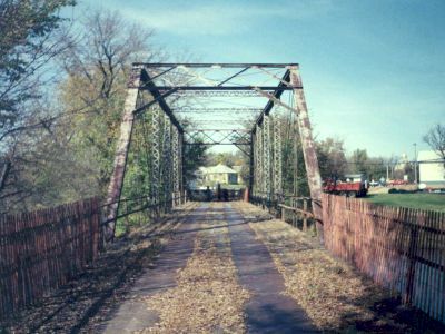
This is where the story of the bridge stops. However, despite getting some answers to my quest for truth about the bridge, there are some questions out there that are still in need of some answering. We do know that the bridge was built much closer to the Pacific Coast and further away from Bakersfield than stated in the report in the 1990s. Judging by the information and the photos provided by the locals, the bridge was built in 1917 but most likely opened to traffic at the end of that year or the beginning of the next. It is unknown how the errors occurred in the report, but they are not unusual, as some surveys of historic bridges in the US conducted either by state agencies or the private sector have presented assumptions and theories, which after doing an even more thorough investigation, have been proven to be further off than expected. An example of such an error is the historical survey conducted on a bridge over the Des Moines River in Jackson, Minnesota, the Petersburg Road Bridge.  Assumptions were made during the surveys in the 1980s that the bridge, built using the same truss design and similar portal bracings, was built in the 1930s, yet further research indicated that Joliet Bridge Company constructed this bridge in 1907 and there were no further records of bridge construction at that site. The bridge was removed in 1995.

The case of mistaken identity: The Petersburg Road Bridge in Jackson, Minnesota. Photo taken in 1992 after the bridge was condemned to all traffic.


With the advancement of technology and more availability of information, researching bridges, like the US 101 Buellton Bridge has become more transparent and thorough, which serves as a blessing for many who are interested in their history, and in more cases than none, preserving them.

But time is running out for two of the remaining four US 101 spans that exist in Harrison County, and as mentioned earlier, there are still more questions to be answered which will not only round off the story of the original bridge, but in the cases of these two and perhaps the other three that were relocated somewhere else, one can prove the case and take action in listing them onto the National Register of Historic Places and preserving them for future recreational use. There have been some talks of keeping the Nelson Bridge in service while trying to salvage the East Kelley Lane Bridge (or at least parts of them), but these plans lie on the will of the locals in Harrison County, many of whom would like to see some history saved.

So here are some additional questions which might be of interest to not only the pontists and historians, but also to the locals of Harrison County, Iowa and Santa Barbara County, California. Some will require researching through the newspaper articles and records. Others will require some interviews. Here they are:

1. It is mentioned in the sources (from California) that the county either built the state structures or had signed an agreement to build them. How was it with the Buellton Bridge when it was built in 1917? Who oversaw the construction of the bridge and where did the trusses come from (bridge company and steel manufacturer)?

2. While it is confirmed that all seven truss spans were dismantled and four were sent to Iowa, what happened to the remaining seven spans? Were all seven spans sold to Highway Bridge Company, which then dispersed them to different locations, or were the three spans kept in California and erected elsewhere in the state? Who was in charge of dismantling the bridge to begin with?

3. Who were the Western Steel Cutting Company and the Highway Bridge Company and what were their roles in bridge building in the late 1940s and early 1950s?

Any leads can be sent to the author, Jason Smith at the following e-mail address: flensburg.bridgehunter.av@googlemail.com. As soon as some leads show up, a follow-up report will follow.


Riverside Bridge: No Trespassing or else! Ordinance passed

The Christian County Commissioners on Thursday passed an ordinance barring anyone from entering and crossing the bridge. Those caught crossing the bridge will be fined $500. According to the County Commissioner Lou Lapaglia, the ordinance was justified for two reasons, which were for fear of liability in case anyone is hurt on the bridge and fear of vandalism to the bridge. Until further notice, the bridge will remained fenced off on both ends to ensure that no one enters or cross the bridge.

The ordinance does produce some mixed reactions on the part of many people including the author of the Chronicles. On the one hand, since the organization wanting to save the bridge and its director, Kris Dyer want to renovate the bridge for pedestrian use, fencing off the bridge does make sense in a way that it would keep potential vandals off the bridge. In the past, bridges closed to vehicular traffic but left open for pedestrians have witnessed various sorts of vandalism, stemming from spray painting certain bridge parts and the flooring to setting fire to the bridge deck destroying sections of it to even taking sections of the bridge, like in the case of a through truss bridge, ornaments, plaques and railings. An example of such an act occurred in 1996, when a group of teenagers set a wooden trestle bridge outside of Chaska, Minnesota (near Minneapolis) on fire, even though the structure was destined to become a pedestrian trail after the railroad company that owned it, Chicago and Northwestern (now part of Union Pacific) had abandoned it. The fire severely damaged 70% of the entire structure, including the trestles supporting the deck. It was unknown whether or not the arsonists were ever found, but the bridge was fenced off afterwards and is now facing being washed away by the upcoming floods destined to hit the Twin Cities in April. This incident was a fine example of how barricading a bridge is justified to avoid incidents like this and the liability that goes along with crossing the bridge.

Link to the bridge: http://pegnsean.net/~johnm/Chaska%20Trestle.html

Yet on the other hand, erecting an 8-foot fence at both ends of the bridge to keep people off the bridge and enforcing an ordinance is overexaggerating; especially in the eyes of those who wanted to keep the bridge open; even one suggested posting a sign saying ENTER AT YOUR OWN RISK, which was rejected for liability reasons by the county commission. Many bridges, like the Riverside Crossing were restricted to pedestrian traffic for many months or even years without any reports of litigation because of injury on the structure. Many people in Ozark use this bridge on a regular basis to walk or bike across the river. Unfortunately, this option can no longer be used and alternative crossings will have to be found and used until the bridge reopens again.

Such cases are no stranger, as a bridge in Jackson County, Minnesota for example suffered that particular fate, with the Petersburg Road crossing located in the southern end of its county seat, Jackson. Built in 1907 by Joliet Bridge and Iron Company, this single span Pratt through triss bridge was closed to traffic in 1985 due to structural deterioration, but a group managed to keep it open to pedestrians and bikers for another seven years until it was fenced off in November 1992. This served as an excellent shortcut for many living in the southern end of town; especially the children. But with the closing in 1992 and its removal just over two years later, people were forced to use the next crossing three miles upstream- by car only!

Petersburg Road Bridge in Jackson, MN (USA) Photo taken by the author in 1992

The future of the Riverside Bridge is now in the hands of the committee to save the bridge and its director, Kris Dyer. The organization needs enough money to make the necessary repairs and make it safe for use as a pedestrian bridge. While it is unclear how much this will all cost, estimates for making the repairs according to Matthews Engineering ranged from $130-180,ooo. The engineering consultant will present a full report on the bridge to determine the condition of the bridge and all eyes will be on not only the state of the structure, but also the estimates for fixing the bridge to reopen again and whether or not Missouri Department of Transportation will allow the bridge to be reopen period, as the agency, which is involved in the project, had recommened the bridge be closed to both vehiculars (which happened in September, 2010) and pedestrians (half a year later).  Also important is whether the county will help at all with the work- as it is $700,000 in debt according to Lapaglia- or will take advantage of cost-cutting measures and federal funding available by demolishing the bridge and replacing it with a current structure instead of looking for alternatives, like having a crossing on a different alignment. In either case, even if demolition is preferred, because the bridge is eligible for nomination on the National Register of Historic Places, it must go through the Section 106 process, which was introduced as part of the 1966 National Preservation Act and whose mission is to determine the environmental impact of altering or replacing the bridge as well as find alternatives to demolition. This process could take months to complete and perhaps by the time it is finished, there will be enough funds to rehabilitate and reopen the bridge.

More to come as the events unfold…..

If you are interested in donating to save the bridge, here are a couple links to help you. The second link is a facebook page which has some information on how to donate for the cause. Please preserve an important fabric of American history by making a donation. Every little bit does make a big difference.

Links:

1. https://ssl.4agoodcause.com/cfozarks/donation1.aspx?id=1

2. http://www.facebook.com/saveriversidebridge?sk=info