
While on the subject of the German state of Saxony-Anhalt as there is a quiz on this subject (click here to challenge yourself), there are a few historic bridges in the state that many of us don’t know about. Many of them have been abandoned, and the little records that may have existed in the past vanished because of war and political oppression. Saxony-Anhalt was one of five German states that fell under the rule of two different dictators between 1933 and 1990: The first with Hitler and the second under Communism. During that time, records of these structures were either lost or altered in an attempt to prop up the goodness of these two regimes, when they anything but that.
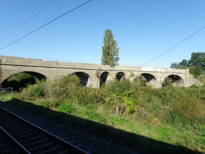
This railroad viaduct in Grosskorbetha is one of these gigantic structures that has been sitting abandoned for decades and whose records on its history may have been lost to time and the iron fist. Grosskorbetha is a village in southern Saxony-Anhalt thatis the bridge between the industrial area to the north and the wine industry to the south. It is a transitional point in terms of landscape where going south, one can see the limestone hills lining along the Saale and Unstrut Rivers. Going north, it has nothing but flat plains. It is an outlyer to the megalopolis region of Leipzig and Halle, which includes Bad Durrenberg, Merseburg, Schkopau, Delitzsch and Bitterfeld-Wolfen. And it is the Grand Central Station (or in German terms, Hamburg Hauptbahnhof) for all freight trains, especially as they branch off into three parts going north: to Leipzig, to Halle and to the petroleum area in Leuna. For passenger train service, no one can escape seeing these trains and industrial complexes when passing through.
And for this railroad bridge, which is an nine-span closed spandrel concrete arch bridge, it is the structure which one will pass through by train, noticing all the cracks and spalling, the barriers keeping everyone off the structure, but one will have a difficult time photographing it. This shot was taken by train but at speeds of 120 km/h. The bridge is located a kilometer north of the train station, which makes walking ti the structure impossible, given the high volume of traffic at this junction. Even Nathan Holth would face the wrath of the Bahn in one form or another if he was to even try to walk to the bridge. 😉 But what we can say about the bridge is it is at least 80 years old, and it has withstood damages caused by war, wear and tear and trains passing through. Crossing the main passenger lines heading to Leipzig and Halle, one could say the bridge is well over 170 meters long. And the width is enough to hold vehicular traffic in both directions, especially when it connects Leuna and Grosskorbertha. But…..
What else do we know about this bridge? Any ideas in English or German would be of great help.

Author’s Tip: As a tip when photographing bridges like these: If you cannot zoom in with your camera, try by train, but use the speed modus, and fire away as you approach the bridge. If you miss, turn around and try when the train goes away from the bridge. The second step is easier than the first, but you will be able to get a “drive-by” shot while the train is in motion. My success here came after the train passed through the bridge, except it was with the red regional trains which have since been decommissioned due to age. They featured windows you can open and stick your arms and camera out for a good shot. With the newer trains by the rail service Abellio, the windows are fixed shut and it may be more difficult to photograph with a closed window, but still, it is doable.
![]()


For those attempting to follow up on this, it is Grosskorbetha (Großkorbetha), not Grosskorbertha, and apparently carries a former deviation of Dürrenberger Straße (not Durremberg). What is puzzling is that to the East, Dürremberger Straße hardly seems to justify this, and to the West, it seems to be barely more than a Feldweg or farm lane.
A kink in the bridge precludes it ever having been intended for railway use. But following the Feldweg further west on satellite views, it is evident (on Bing, not Google) that the road once continued further West from its current T ending, across a farm field and very probably across what is now the Großkaynaer See. The latter is a former open pit mine, that must have grown to sever the old road, thus demoting what was once a main road from Bad Dúrrenburg to Freyburg to eventual lowly status as Feldweg or faint shadings in tilled fields.
Speculative perhaps, but I consider it very likely, though failing to inform on the construction or design history of the actual bridge itself.
LikeLike
I made the spelling changes to the two aforementioned towns. Thanks for pointing that out.
LikeLike
Update: I got some information from the City of Halle about this bridge and learned that the bridge was built in segments between 1910 and 1944 but has been out of use for many decades. The Wengersdorf Bridge, as locals named it, is owned by both the Deutsche Bahn (German Railways) and the City of Weissenfels and is expected to be removed in the next two years. It had been barracaded with concrete on both ends to keep people off this deteriorating structure but the motive behind the demolition is because it is no longer needed. Information on the bridge removal plan can be found here: http://www.mz-web.de/weissenfels/wengelsdorf-alte-bahnbruecke-wird-abgerissen-2252184
LikeLike